Browse Listings in America > North America > Great Lakes / Philadelphia
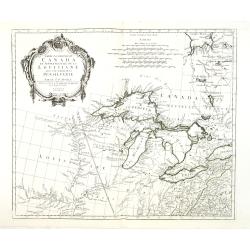
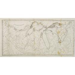
Partie Occidentale du Canada et Septentrionale de la Louisiane..
Fine copper engraved map of the Great Lakes region after d'Anville's, to whom Santini gives credit in the cartouche.The map extends from the upper Mississippi River valle...
Place & Date: Venice, 1776 - 1784
Selling price: $465
Sold in 2013
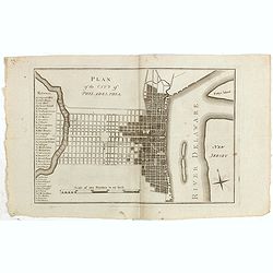
Plan of the city of Philadelphia.
Rare plan of Philadelphia with a lettered key to the important buildings (A. Congress Hall, B. State House C. City Hall, (. . .) W. Bank U.S. X. Bank Penn. Y. Bank N.A., ...
Place & Date: Philadelphia, 1794
Selling price: $1550
Sold in 2015
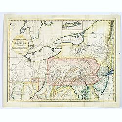
Map of the Middle States of America, comprehends New-York, New-Jersey, Pennsylvania, Delaware, and the Territory N.W. of Ohio.
An interesting map of the region of the United States extending from New Jersey to Indiana, and from northern New York to Maryland. Detail in the east is plentiful, with ...
Place & Date: London, 1794
Selling price: $255
Sold in 2017
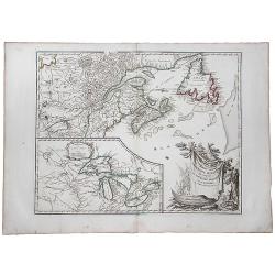
Partie de L'Amerique Septent. Qui comprend La Nouvelle France ou le Canada.
A decorative and highly detailed map of New England and part of Canada, extending east to Newfoundland, with a large inset map of the Great Lakes.One of the best large fo...
Place & Date: Paris, 1797
Selling price: $180
Sold in 2019

Philadelphia in Amerika. / Bonaparte an der spitze seiner Pariser National Garde am 8 Novemb. 1799
Copper engraving with four scenes on one sheet. In upper part a view of Philadelphia. Published in "Allgemeine Welt-Chronik oder neue und wichtige Zeit-Geschichte al...
Place & Date: Zittau, 1798-1800
Selling price: $1200
Sold
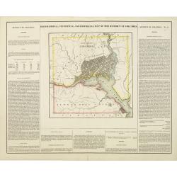
Geographical, statistical, and historical map of the district of Columbia.
Includes a detailed plan of Washington DC, Georgetown and Alexandria and a number of roads and rivers in the District. Muds Tavern is shown just outside the District on t...
Place & Date: Philadelphia, 1822
Selling price: $375
Sold in 2010
Map of the Country Embracing the Route of the Expedition of 1823 commanded by Major SH Long.
Folding map originating from the rare book "Narrative of an Expedition to the Source of St. Peter's River : Lake Winnepeek, Lake of the Woods, &c., &c. Perfo...
Place & Date: H.C.Carey and E. Lea, 1824
Selling price: $310
Sold in 2008
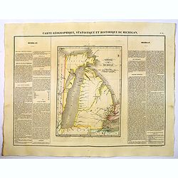
Carte Geographique, Statistique et Historique de Michigan.
A nice detailed map of Michigan, from Buchon's Atlas Gégraphique Statistique, historique et chronologique des deux Ameriques et des isles adjacentes traduit de l'atlas e...
Place & Date: Paris, 1825
Selling price: $100
Sold in 2019
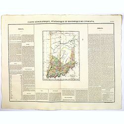
Carte Geographique, Statistique et Historique de L'Indiana.
A nice detailed map of the state of Indiana from Buchon's Atlas Gégraphique Statistique, historique et chronologique des deux Ameriques et des isles adjacentes traduit d...
Place & Date: Paris, 1825
Selling price: $50
Sold in 2019
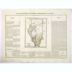
Carte Geographique, Statistique et Historique de Illinois.
A nice detailed map of the state of Illinois, from Buchon's Atlas Gégraphique Statistique, historique et chronologique des deux Ameriques et des isles adjacentes traduit...
Place & Date: Paris, 1825
Selling price: $55
Sold in 2019