Browse Listings in America > North America > Great Lakes / Philadelphia
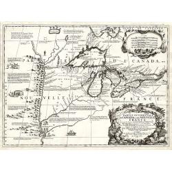
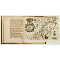
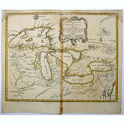
Partie Occidentale du Canada ou de la Nouvelle France...
A very rare map of the Great Lakes by Coronelli / Nolin and one of the most beautiful, acquirable works to focus on the region. As Tooley states, ?it was the best represe...
Place & Date: Paris, 1688
Selling price: $7000
Sold
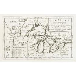
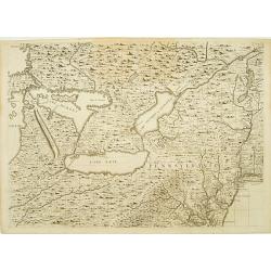
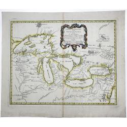
La Lovisiana, Parte Settentrionalle, Scoperta sotto la Protettione di Luigi XIV, Rè di Francia..
One of the most important maps of the Great Lakes and Upper Mississippi, based upon reports of La Salle, Hennepin, Marquette, Jolliet and other French Jesuits who were ac...
Place & Date: Venice 1690
Selling price: $2700
Sold
Nova Svecia hodie dicta Pensylvania.
Very rare map shows the location of Swedish settlements on the Delaware River.Prepared by Peter Lindström in 1655, who made a map titled Nova Svecia, anno 1654 och 1655,...
Place & Date: Stockholm 1702
Selling price: $1600
Sold
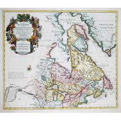
Carte du Canada ou de la Nouvelle France. . .
First issued by Guillaume Delisle in 1703, this important, detailed map provides the most accurate rendering of the Great Lakes of the time, with the lakes fully enclosed...
Place & Date: Amsterdam, c.1730
Selling price: $1300
Sold in 2019
Delineatis Pennsylvaniae et Caesereae nov. Occidebt seu West Niersey in America.
An extremely rare map of Pensylvania and New Jersey engraved by Jonas Silfverlong. Published in a publication by Tobias Biorck titled Dissertatio Gradualis, de Plantation...
Place & Date: Upsula 1731
Selling price: $4500
Sold
Sheet 6 of 20: The Great Lakes and New Jersey.
One sheet of H.Popple's twenty-sheet survey of North America, in a first state, the first large-scale map of the British colonies in America. Featuring the Great Lakes in...
Place & Date: London 1733-1735
Selling price: $1625
Sold
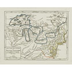
Les Lacs du Canada et Nouvelle Angleterre.
Charming small map showing the Great Lakes region from Superior to Ontario and including the northern part of Pennsylvania below Lake Erie, although the state is not name...
Place & Date: Paris, later than 1749
Selling price: $230
Sold
Partie Occidentale de la Nouvelle France ou des Canada.
A fine large-scale map derived from Bellin's landmark map of the Great Lakes which first appeared in Charlevoix's Histoire in 1744. The chart incorporates the work of Sie...
Place & Date: Nuremberg, 1755
Selling price: $1500
Sold in 2015
Partie Occidentale de la Nouvelle France ou de Canada.
An important and influential map of the Great Lakes region during the time of French colonial occupation. This map was originally engraved by Jacques Bellin in 1745, howe...
Place & Date: Nuremberg, 1755
Selling price: $550
Sold in 2017
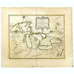
Partie Occidentale de la NOUVELLE FRANCE ou du CANADA.
A fine large-scale map derived from Bellin's landmark map of the Great Lakes which first appeared in Charlevoix's Histoire in 1744. However, Homann's publication is more ...
Place & Date: Nuremberg, 1755
Selling price: $1000
Sold in 2020