Browse Listings in America > North America > Great Lakes / Philadelphia
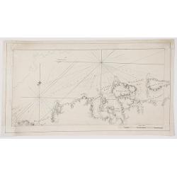
![[Detroit] La Rivière du Détroit Depuis le lac Sainte Claire jusqu'au Lac Erié.](/uploads/cache/17065-250x250.jpg)
[Detroit] La Rivière du Détroit Depuis le lac Sainte Claire jusqu'au Lac Erié.
This is the first separately printed map of Detroit, showing the village, fort, anchorages, islands and navigational hazards, with an inset of the fort with five lettered...
Place & Date: Paris 1764
Selling price: $625
Sold
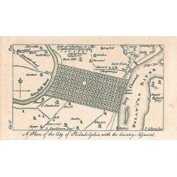
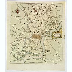
A Plan of the City of Philadelphia, with the Country Adjacent.
Early small plan of Philadelphia, published in "The World displayed; or, a curious collection of voyages and travels...". Quite detailed with roads and houses...
Place & Date: London, 1767
Selling price: $100
Sold in 2010
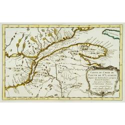
Carte du cours du Fleuve de St.Laurent..
Uncommon edition of this accurate map showing the lower St.Laurence. Second state.From Atlas Portatif pour servir a l'intelligence de l'Histoire Philosophique et Politiqu...
Place & Date: Amsterdam 1773
Selling price: $400
Sold
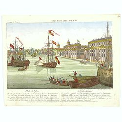
Vue de Philadelphie.
An attractive optical prints of Philadelphia, the capital of Pennsylvania, and the future fledgling nation's capital, during the Revolutionary war with Britain. A harbour...
Place & Date: Augsburg, 1776
Selling price: $230
Sold in 2016
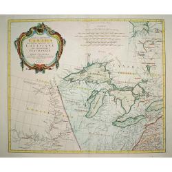
Partie Occidentale du Canada et Septentrionale de la Louisiane..
Fine copper engraved map of the Great Lakes region after d'Anville's, to whom Santini gives credit in the cartouche.The map extends from the upper Mississippi River valle...
Place & Date: Venice, 1776
Selling price: $560
Sold in 2009

A plan of the City and Environs of Philadelphia. . .
The Lotter edition of Scull & Heap's seminal Philadelphia map, which map was first issued in 1752.Holmes' grid plan for the city is shown, situated between the rivers...
Place & Date: Augsburg, 1777
A Chart of New York Island & North River: East River, Passage Through Hell's Gate, Flushing Bay, Hampstead Bay ...... (Fragment Only)
This is a fragment of a very important, large chart. It was produced by Joseph Des Barres in London in 1777. The full map shows Long Island north shore from Eaton’s N...
Place & Date: London, 1777
Selling price: $500
Sold in 2017
A Map of Philadelphia and Parts Adjacent.
A nice example of the 1777 Revolutionary War edition of the Scull & Heap map of Philadelphia, published by the Gentleman's Magazine. The Scull & Heap map went thr...
Place & Date: London, 1777
Selling price: $425
Sold in 2019
![LA PENSILVANIA, LA NUOVA YORK, IL JERSEY SETTENTRIO:le, CON LA PARTE OCCIDENTALE DEL CONNECTICUT. . . (Fogl. V.)[Lakes Huron, Erie, and Ontario]](/uploads/cache/83531-250x250.jpg)
LA PENSILVANIA, LA NUOVA YORK, IL JERSEY SETTENTRIO:le, CON LA PARTE OCCIDENTALE DEL CONNECTICUT. . . (Fogl. V.)[Lakes Huron, Erie, and Ontario]
A striking map of the north eastern section of the Italian edition of Mitchell's seminal map of North America, bounded by Lakes Huron & Oswego and Ohio in the west an...
Place & Date: Venice, 1778
Selling price: $240
Sold in 2020
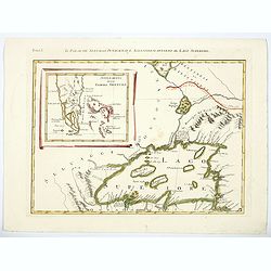
Il Paese de Selvaggi Outauacesi e Kilistinesi Intorno al Lago Superiore.
This is one sheet from Antonio Zatta's version of John Mitchell's epic map. The whole map was titled "Le Colonie Unite dell' America Settentrle" and was publish...
Place & Date: Venice, 1780
Selling price: $195
Sold in 2020