Browse Listings in America > Caribbean & Atlantic Ocean > Atlantic ocean general
![[ Caribs idoles and weapons ].](/uploads/cache/27336-250x250.jpg)
[ Caribs idoles and weapons ].
Aquatint depicting Caribs' idoles and weapons. Engraved by Raineri.From Giulio Ferrario's work Le Costume Ancien et Moderne ou Histoire du gouvernement, de la milice, de ...
Date: Milan, 1827
Selling price: ????
Please login to see price!
Sold in 2020
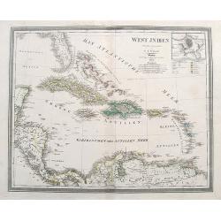
WEST INDIEN.
A large map of Florida, the Bahamas, the Caribbean Islands, and parts of Central America and South America.Highly detailed with many place names given. colors indicate th...
Date: Weimar, 1844
Selling price: ????
Please login to see price!
Sold in 2018
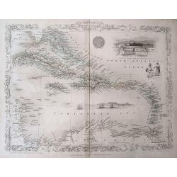
West India Islands.
Beautiful map of the Caribbean - from Florida to Venezuela. Decorated with the embellished borders, a view of Kingston in Jamaica, sailing ships, and a native couple. Exc...
Date: London, ca. 1850
Selling price: ????
Please login to see price!
Sold in 2016
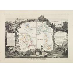
Colonies Françaises (en Amérique.)
A very decorative 19th century map showing the islands of St Martin, St Pierre et Miquelon and Terra Nova. Includes also Guyana. The map is surrounded by portraits, anima...
Date: Paris 1850
Selling price: ????
Please login to see price!
Sold
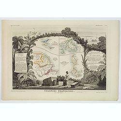
Colonies Françaises (en Amérique.)
A very decorative 19th-century map showing the French Colonies in the Americas, the islands of St Martin, St Pierre et Miquelon and Terra Nova. Includes also Guyana. The ...
Date: Paris, 1850
Selling price: ????
Please login to see price!
Sold in 2021
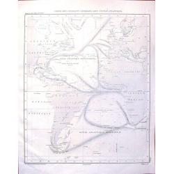
![Maury's wind & current chart 3rd edition 1849. no.8 series A. [with] Maury's wind & current chart 3rd edition 1852. no.2 series A. [with] Storm and rain chart of the north Atlantic. . .](/uploads/cache/39424-250x250.jpg)
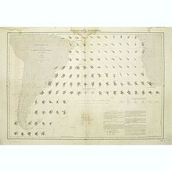
Maury's wind & current chart 3rd edition 1849. no.8 series A. [with] Maury's wind & current chart 3rd edition 1852. no.2 series A. [with] Storm and rain chart of the north Atlantic. . .
Three rare charts with winds and currents in the North Sea and Atlantic Ocean. - Maury's wind & current chart 3rd edition 1849. no.8 series A. - Maury's wind & c...
Date: USA, 1849, 1852
Selling price: ????
Please login to see price!
Sold in 2017
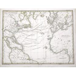
Der Atlantische Ocean
A very interesting map of the Atlantic Ocean, showing several routes (with dates) between Europe and the Americas. Includes the tracks of Columbus' first voyage, Humboldt...
Date: Gotha, 1853
Selling price: ????
Please login to see price!
Sold in 2016
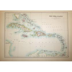
West India Islands
A superb map of the West Indies and the tip of Florida - Venezuela, drawn and engraved by William Hughes – Sidney Hall steel engraved. Published by Adam & Charles B...
Date: Edinburgh, 1854
Selling price: ????
Please login to see price!
Sold in 2016
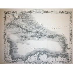
West India Islands
This is the uncommon and slightly later edition by Rapkin based on Tallis' maps. The vignettes have been removed and the map is issued in black and white. The map extends...
Date: London 1855
Selling price: ????
Please login to see price!
Sold
Carte des Courants Generaux dans L'Ocean Anlantique.
Fine lithographed sea chart by Depot des Cartes et Plans de la Marine featuring the sea currents in the Atlantic Ocean. It was engraved by Jacobs from drawings by Charles...
Date: Paris, 1856
Selling price: ????
Please login to see price!
Sold in 2016
Atlantique sud carte de la direction et de l'intensité propable des vents. . . Juillet, Aout, Septembre.
Map of the south of Atlantic Ocean. Showing South America and South Africa and the different wind directions for July, August, and September prepared by L.Brault.
Date: Paris, 1876
Selling price: ????
Please login to see price!
Sold in 2011
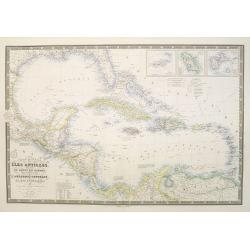
Carte générale des Iles Antilles, des iles et bancs de Bahama, des Etats-Unis . . .
Scarce and large (614 x 930 mm / 24.2 x 36.6 inches) map of the Caribbean, including the Gulf coast and central America, and insets of the Virgin Islands, Martinique and ...
Date: Paris, 1876
Selling price: ????
Please login to see price!
Sold in 2023
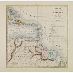
Carte des Colonies Françaises aux Antilles.
Uncommon map including Venezuela, French Guiana, Suriname, and the islands in the Caribbean. With a color key to the French, English, Spanish, Dutch and Danish possession...
Date: Paris, Abel Pilon & Co., c.1880
Selling price: ????
Please login to see price!
Sold in 2012
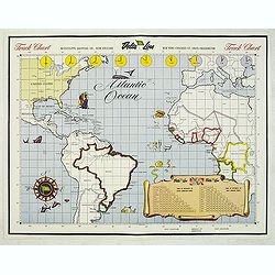
Track Chart
Map of the Atlantic Ocean, used as a hand out to the passangers to keep daily track.
Date: New Orleans, c. 1950
Selling price: ????
Please login to see price!
Sold in 2015
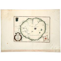
Isola di MARIA GALANTE neel Antilli. . .
A nice example of Coronelli's map of the island of Maria Galante, from his 'Isolario Dell'Atlante Veneto'. This is one of the few separate maps of the island of Marie-Gal...
Date: Venice, ca 1690
Selling price: ????
Please login to see price!
Sold in 2020
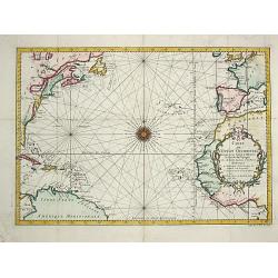
Carte de l' Ocean Occidental.
Jaques Nicolas Bellin (1702-720) was the most important French hydrographer of the 18th century. Sea-atlas 'Hydrographique Français' , 1756-65, atlas to accompany Prévo...
Date: Paris, 1746.
Selling price: ????
Please login to see price!
Sold
