Browse Listings in America > Caribbean & Atlantic Ocean > Atlantic ocean general
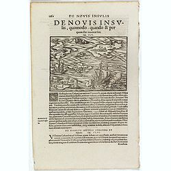
De Novis Insulis, Quomodo quando . . .
Text page with a map of unspecified islands in the New World (140 x 145 mm). with sea monsters on the recto. From Münster's Cosmographia Universalis.The Cosmographia by ...
Place & Date: Basle, ca. 1564
Selling price: $50
Sold in 2017
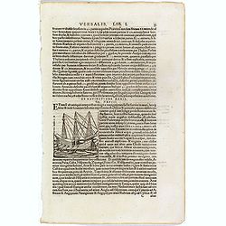
De Navigatione Maris.
One Latin text page about navigation, early voyages, and illustrated with a ship (68 x 64 mm), who was lateron used to illustrate Christopher Columbus ship. On verso an i...
Place & Date: Basle, ca. 1564
Selling price: $10
Sold in 2018
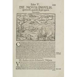
Liber V. De Novis insulis quomodo, quando & per quem illae inuentae sint.
Map of unspecified islands in the New World, printed area 105 x 160mm, set in a large page of text. From an Latin text edition of the Cosmography. One of the earliest obt...
Place & Date: Basle, c. 1580
Selling price: $100
Sold in 2009
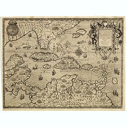
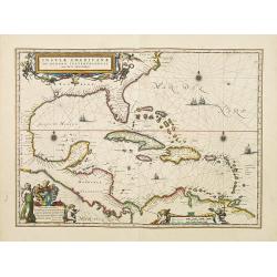
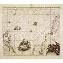
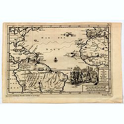
Occidentalis Americae partis..
The most beautifully engraved early map of the Caribbean, including Florida and the Southeast. The map includes representations of Columbus' ships and various notes regar...
Place & Date: Frankfurt 1594
Selling price: $4500
Sold in 2019
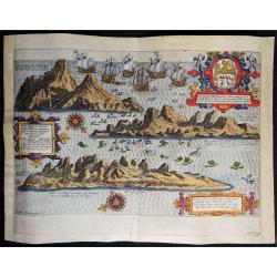
Vera effigies et delineatio Insulae, Ascencio nuncupatae (...) Waerachtighe affbeeldinghe en verthooninghe vant Eylant Asçençion (...)
A rare copper engraved bird's eye view by B. VAN DOETECUM of the island of Ascension in the South Atlantic Ocean. Panorama showing the island in three profile views, engr...
Place & Date: Amsterdam, 1596
Selling price: $375
Sold in 2019
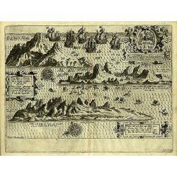
Insula D.Helenae sacra coeli..
A fine perspective view of the Island of St.Helena in the South Atlantic. The location of the Island directly on the navigation route from Europe to the Cape of Good Hope...
Place & Date: Amsterdam 1598
Selling price: $1225
Sold
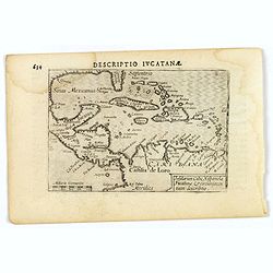
Descriptio Iucatana.
An attractive miniature map of Mexico, Florida, the very north of South America and the Caribbean, published by Petrus Bertius, in Amsterdam at the beginning of the seven...
Place & Date: Amsterdam, 1606
Selling price: $95
Sold in 2019
Mar di Aethiopia.
This from Johannes Janssonius' sea-atlas 'De Water-Weereld' covers the area between the Cape of Good Hope and the most southern tip of South America. Giving many place n...
Place & Date: Amsterdam, 1640
Selling price: $600
Sold in 2021
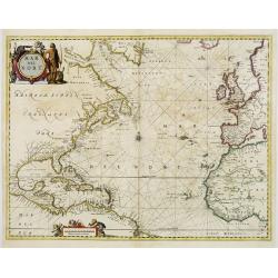
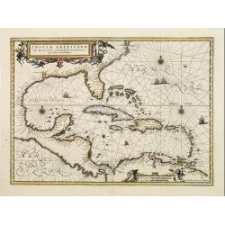
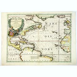
Insulae Americanae in Oceanus Septentrionali cum Terris..
General map of the West Indies extending from Virginia to the mouth of the Orinoco, and destined to be copied in various shapes by many other publishers.Title cartouche t...
Place & Date: Amsterdam 1640
Selling price: $1320
Sold
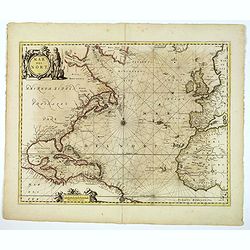
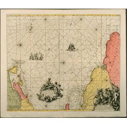
Mar del Nort.
This chart from Johannes Janssonius' sea-atlas 'De Water-Weereld'. The decorative title cartouche shows a native American (as interpreted in Europe!) and various species ...
Place & Date: Amsterdam, 1657
Selling price: $1750
Sold in 2008
Mar del Nort.
This lovely sea chart is from the Johannes Janssonius' sea-atlas De Water-Weereld. The decorative title cartouche shows a native American (as interpreted by those in Euro...
Place & Date: Amsterdam, 1657
Selling price: $700
Sold in 2020
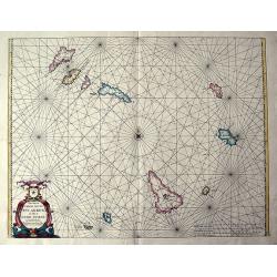
Pascaerte vande soute Eylanden oste Ilhas de Cabo Verde.
RARE sea chart of the Cape Verde Islands by Johannes van Loon. The islands shown with its towns and anchoring places. Island of Del Fuogo is shown with an erupting volcan...
Place & Date: Amsterdam, c. 1660
Selling price: $425
Sold in 2020
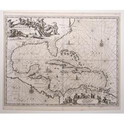
Insulae Americanae in oceano septentrionali..
Finely engraved map, showing the Gulf of Mexico and the West Indian Islands, and the adjacent North and South American coastlines.The cartography is based on the rare Ger...
Place & Date: Amsterdam 1660
Selling price: $650
Sold
![[Atlantic Ocean] Carta particolare dell mare Oceano fra la costa di Guinea e la Brasilia.](/uploads/cache/81883-250x250.jpg)
[Atlantic Ocean] Carta particolare dell mare Oceano fra la costa di Guinea e la Brasilia.
A large, small-scale, so-called cross-over chart of the Atlantic Ocean on two sheets. From Robert Dudley's atlas Arcano del Mare, with the coast of Africa and the eastern...
Place & Date: Florence, 1661
Selling price: $950
Sold in 2019
Insulae Americanae in Oceano Septentrionali, cum Terris adiacentibus.
Copper engraved map; overall size 31 x 37 cm by Arnoldus Montanus, from his: 'De Nieuwe en Onbekende Weereld: of Beschryving van America'. Montanus' derivation of Blaeu's...
Place & Date: Amsterdam, 1671
Selling price: $450
Sold in 2017
.Pascaerte vande Vlaemsche, Soute, en Caribesche Eylanden, als mede Terra Nova,. . .
This fine and scarce sea chart covers the central Atlantic and extends to include the Maritime Provinces, Antilles and the northwest coast of South America, east to the A...
Place & Date: Amsterdam, 1672
Selling price: $800
Sold in 2013
Terra Nova, ac Maris Tractus circa Novam Franciam, Angliam, Belgium, Venezuelam Novam Andalusiam, Guianam et Brasiliam...
A fantastic sea-chart showing the coastlines of North America, the West Indies, and the northern parts of Brazil. The chart extends from Newfoundland and the St Lawrence ...
Place & Date: Amsterdam, 1675
Selling price: $900
Sold in 2019
Terra nova, ac maris tractus circa Novam Franciam. . .
Chart of the Atlantic Ocean, showing the east coast of North America from New Foundland till Long Island and the West Indies from Hispaniol to the most eastern tip of Bra...
Place & Date: Amsterdam, 1675
Selling price: $1500
Sold in 2014
Paskaert waer in de graden.. custen van Africa en America..
Very fine , showing the points where the Dutch West India Company sailed: including Ireland, Portugal, Morocco, east coast of Africa, the Canary Islands, the Azores, Braz...
Place & Date: Amsterdam, 1680
Selling price: $2900
Sold in 2013
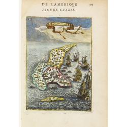
I. de Guanahani ou de St. Salvador.
Charming map of the Guanahani Island, inserted in a perspective view of the Atlantic ocean and embellished with vessels approaching the shores.From the French text editio...
Place & Date: Paris 1683
Selling price: $50
Sold
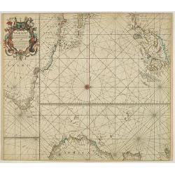
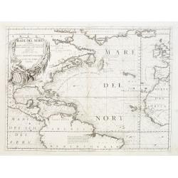
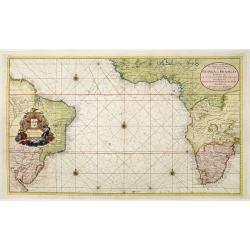
Mare del Nord.
This splendid maritime map shows the Atlantic Ocean between Iceland, Europe, West-Africa, northern Brazil and eastern Canada, including the Caribbean. Here Coronelli deli...
Place & Date: Venice, 1690
Selling price: $800
Sold in 2020
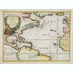
Mare del Nord.
Shows the Atlantic Ocean between Iceland, Europe, West-Africa, Brazil and Canada, including the Caribbean. Here Coronelli splendidly delineates the center of European eco...
Place & Date: Venice 1690
Selling price: $1193
Sold
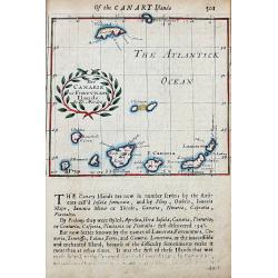
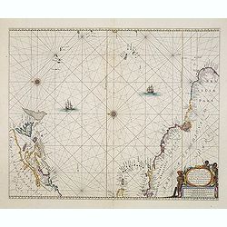
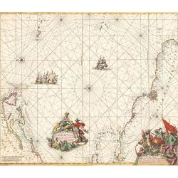
The Canarie or Fortunate Ilands
A rare early map of the Canary Islands and Madeira. The small map shows the main towns on the islands, and also the Pico del Teide mountain. Below the map and on verso wi...
Place & Date: London, ca. 1690
Mare del Nord.
Shows the Atlantic Ocean between Iceland, Europe, West-Africa, Brazil and Canada, including the Caribbean. Here Coronelli splendidly delineates the center of European eco...
Place & Date: Venice, 1690
Selling price: $550
Sold in 2013
![Cuba Insula [on sheet with] Hispaniola Insula [and] Ins. Iamaica [and] Ins. S. Ioannis [and] I.S. Margareta.](/uploads/cache/82456-250x250.jpg)
Cuba Insula [on sheet with] Hispaniola Insula [and] Ins. Iamaica [and] Ins. S. Ioannis [and] I.S. Margareta.
A fine map of the important islands in the West Indies. This Cloppenburgh map features the islands, wonderful cartouches, distance scales, and several sailing ships decor...
Place & Date: Amsterdam, 1690
Selling price: $175
Sold in 2020
The Canarie or Fortunate Ilands
A rare early map of the Canary Islands and Madeira. The small map shows the main towns on the islands, and also the Pico del Teide mountain. Below the map and on verso wi...
Place & Date: London, ca. 1690
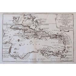
Les Isles De L'Amerique Connues Sous le Nom D'Antilles, ou Sont les Isles de Cuba, St. Domingue et Jamaique, les Lucayes, les Caribes, et celles du Vent.
A detailed copper engraved map of the West Indies, from Florida and the Bahamas until Venezuela and Trinidad. With many place names, islands, bays, and several notes on t...
Place & Date: Paris, 1705
Selling price: $135
Sold in 2017
H. Benzos Scheep-togt uit Italie over Spanje na de Westindize Eylanden, en Kusten van't Zuider America.
A delightful map of the Atlantic Ocean highlighting the route of explorer Hieronymus Benzon, who travelled from Spain to the Americas, and back to Italy between 1541-56. ...
Place & Date: Leiden, ca 1710
Selling price: $150
Sold in 2020
Terra Neuf, en de Custen van Nieu Vranckryck, Nieu Engeland, Nieu Nederland, Nieu Andalusia, Guiana en Venezuela
L. Renard's edition of Frederick de Wit's magnificent Atlantic chart oriented to the East. From the 1715 edition of "Atlas de la Navigation et du Commerce". A f...
Place & Date: Amsterdam, 1715
Selling price: $1700
Sold in 2012
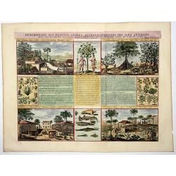
Descriptions des Plantes, Arbres, Animaux & Poissons des Iles Antilles.
An interesting sheet with eight detailed views illustrating fauna and flora on the Antillean islands, and how the slaves make sugar, with descriptive French text, from Ch...
Place & Date: Amsterdam, 1715
Selling price: $170
Sold in 2020
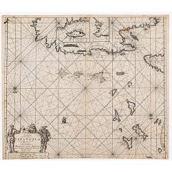
Pas Kaart Van de Noord Kust van Espaniola met d'Eylanden door Benoorden
Double page chart showing the north coast of Hispaniola with the adjacent islands of the Turks and Caicos. Inset charts of the island of Tortue and the bay of Gonaives. T...
Place & Date: Amsterdam: [Gerard van Keulen 1717
Selling price: $590
Sold in 2020
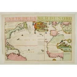
Carte de la Mer du Nord.
Fine map of the Atlantic Ocean. An extremely rare edition of the De Fer map. With 3 inset maps. Lower right Cape of Good Hope, upper right Gibraltar, and in upper center ...
Place & Date: Paris 1719
Selling price: $2100
Sold
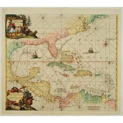
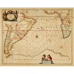
Indiarum Occidentalium Tractus Littoralis cum Insulis..
One of the most splendidly engraved Dutch charts of the Caribbean with two decorative cartouches, one of which illustrates Native American cannibals preparing a meal. Inc...
Place & Date: Amsterdam 1720
Selling price: $3000
Sold
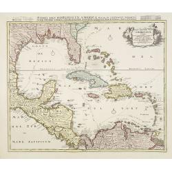
Insulae Americanae Nempe: Cuba, Hispaniola, Iamaica, Pto Rico, Lucania, Antillae vulgo Caribe, Barlo-et Sotto-Vento Etc. . . .
A rare re-issue of the plate by Danckerts. The West Indies with the gulf of Mexico and Florida. The map shows prominently in the centre Cuba, Haiti, the Bahamas and Flori...
Place & Date: Amsterdam, 1720
Selling price: $1500
Sold in 2009
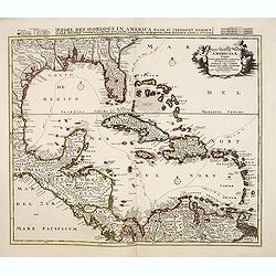
Insulae Americanae Nempe: Cuba, Hispaniola, Iamaica, Pto Rico, Lucania, Antillae vulgo Caribe, Barlo-et Sotto-Vento Etc. . . .
A rare re-issue of the plate by Danckerts. The West Indies with the gulf of Mexico and Florida. The map shows prominently in the center Cuba, Haiti, the Bahamas and Flori...
Place & Date: Amsterdam, 1720
Selling price: $700
Sold in 2013
Nieuwe Wassende graadige Pas-kaart van de kust van Guinea en Brasilia..
Engraved by I.van Anse. A very representative example of a Dutch chart of the Atlantic.The chart shows the western coast of Africa but the information provided in the map...
Place & Date: Amsterdam c.1720
Selling price: $2450
Sold
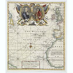
A New Map or Chart of The Western or Atlantic Ocean with Part of Europe, Africa & America: Shewing the Course of the Galleons. . .
An attractive chart of the Atlantic Ocean with large decorative cartouche, from 'The Gentleman's Magazine: and Historical Chronicle', by Sylvanus Urban, printed by Edward...
Place & Date: London, 1740
Selling price: $95
Sold in 2019
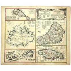
DOMINIA ANGLORUM in praecupuis Insulis AMERICAE ut sunt Insula S. CHRISTOPHORI, ANTEGOA, IAMAICA, BARBADOS, Insulae BERMUDES vel SOMMERS.
Set of 5 maps on a single sheet, outlined hand-colored, showing St. Kitts, Antigua, Bermuda, Barbados, and Jamaica, each in excellent detail with names and descriptions. ...
Place & Date: Nuremberg, 1745
Selling price: $160
Sold in 2020
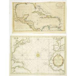
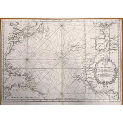
Carte de l'Océan Occidental Dressée pour servir à l'Histoire Générale des Voyageurs. (together with) A new map of the West Indies.
Attractive chart of the Atlantic, north of the equator, delineated with rhumb lines and a large 32-point compass rose.A good portion of each of the continents is shown wi...
Place & Date: Paris, 1746
Selling price: $131
Sold in 2014
Carte de l'Ocean Occidental Dressee pour Servir a l'Histoire Generale des Voyages.
Bellin's superb North Atlantic sea chart. Shows the east coast of North America, the north coast of South America, the West Indies, Western Europe and West Africa. With t...
Place & Date: Paris, 1746
Selling price: $60
Sold in 2013