Browse Listings in America > Caribbean & Atlantic Ocean > Atlantic ocean general
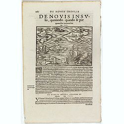
De Novis Insulis, Quomodo quando . . .
Text page with a map of unspecified islands in the New World (140 x 145 mm). with sea monsters on the recto. From Münster's Cosmographia Universalis.The Cosmographia by ...
Place & Date: Basle, ca. 1564
Selling price: $50
Sold in 2017
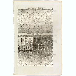
De Navigatione Maris.
One Latin text page about navigation, early voyages, and illustrated with a ship (68 x 64 mm), who was lateron used to illustrate Christopher Columbus ship. On verso an i...
Place & Date: Basle, ca. 1564
Selling price: $10
Sold in 2018
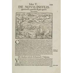
Liber V. De Novis insulis quomodo, quando & per quem illae inuentae sint.
Map of unspecified islands in the New World, printed area 105 x 160mm, set in a large page of text. From an Latin text edition of the Cosmography. One of the earliest obt...
Place & Date: Basle, c. 1580
Selling price: $100
Sold in 2009
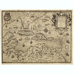
Occidentalis Americae partis..
The most beautifully engraved early map of the Caribbean, including Florida and the Southeast. The map includes representations of Columbus' ships and various notes regar...
Place & Date: Frankfurt 1594
Selling price: $4500
Sold in 2019
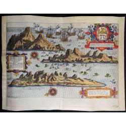
Vera effigies et delineatio Insulae, Ascencio nuncupatae (...) Waerachtighe affbeeldinghe en verthooninghe vant Eylant Asçençion (...)
A rare copper engraved bird's eye view by B. VAN DOETECUM of the island of Ascension in the South Atlantic Ocean. Panorama showing the island in three profile views, engr...
Place & Date: Amsterdam, 1596
Selling price: $375
Sold in 2019
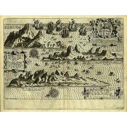
Insula D.Helenae sacra coeli..
A fine perspective view of the Island of St.Helena in the South Atlantic. The location of the Island directly on the navigation route from Europe to the Cape of Good Hope...
Place & Date: Amsterdam 1598
Selling price: $1225
Sold
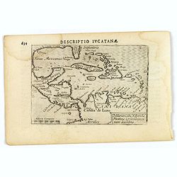
Descriptio Iucatana.
An attractive miniature map of Mexico, Florida, the very north of South America and the Caribbean, published by Petrus Bertius, in Amsterdam at the beginning of the seven...
Place & Date: Amsterdam, 1606
Selling price: $95
Sold in 2019
Mar di Aethiopia.
This from Johannes Janssonius' sea-atlas 'De Water-Weereld' covers the area between the Cape of Good Hope and the most southern tip of South America. Giving many place n...
Place & Date: Amsterdam, 1640
Selling price: $600
Sold in 2021
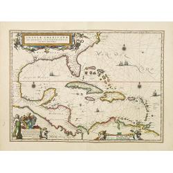
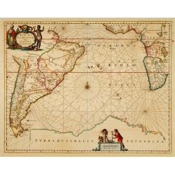
Insulae Americanae in Oceanus Septentrionali cum Terris..
General map of the West Indies extending from Virginia to the mouth of the Orinoco, and destined to be copied in various shapes by many other publishers.Title cartouche t...
Place & Date: Amsterdam 1640
Selling price: $1320
Sold
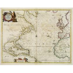
Mar del Nort.
This chart from Johannes Janssonius' sea-atlas 'De Water-Weereld'. The decorative title cartouche shows a native American (as interpreted in Europe!) and various species ...
Place & Date: Amsterdam, 1657
Selling price: $1750
Sold in 2008