Browse Listings in America > Caribbean & Atlantic Ocean > Atlantic ocean general
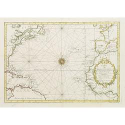
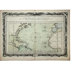
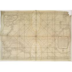
Carte De L'Ocean Occidental Dreessée pour Servir a l'Histoire Generale des voyages..
Attractive chart of the Atlantic, north of the equator, delineated with rhumb lines and a large 32-point compass rose.A good portion of each of the continents is shown wi...
Place & Date: Paris 1746
Selling price: $100
Sold
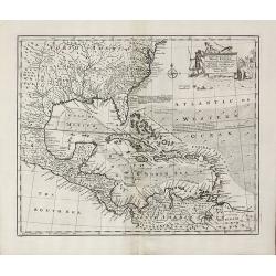
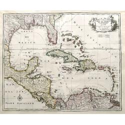
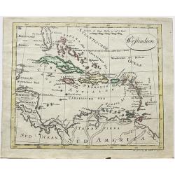
An Accurate Map of the West Indies
Bowen's map of the West Indies from 'A Complete System of Geography'. Showing the area from Long Island in the north to the delta of the Orinoco in the south. Decorated w...
Place & Date: London, 1747
Selling price: $300
Sold in 2011
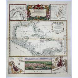
![Mappa Geographica Complectens I. Indiae Occidentalis Partem Mediam Circum Isthmum Panamensem. . . [With insets of St. Augstine, Florida, Mexico City, Panama, etc.]](/uploads/cache/42979-250x250.jpg)
Mappa Geographica Complectens I. Indiae Occidentalis Partem Mediam Circum Isthmum Panamensem. . . [With insets of St. Augstine, Florida, Mexico City, Panama, etc.]
Six varying sized insets depict the West Indies: Panama, Saint Augustine, Vera Cruz, Santo Domingo, and a birds-eye view of Mexico City. The primary, largest inset map ha...
Place & Date: Nuremberg, 1750
Selling price: $450
Sold in 2019
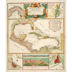
Mappa Geographica complectens. I. INDIAE OCCIDENTALIS partem mediam circum ISTHMUM PANAMENSEM. II. Ipsung Isthmuin. III. Ichnographiam praecipuorum locorum. . .
Six varying sized insets depict the West Indies: Panama, Saint Augustine, Vera Cruz, Santo Domingo, and a birds-eye view of Mexico City. The primary, largest inset map ha...
Place & Date: Nuremberg, 1750
Selling price: $450
Sold in 2020
![Mappa Geographica Complectens I. Indiae Occidentalis Partem Mediam Circum Isthmum Panamensem. . . [With insets of St. Augstine, Florida, Mexico City, Panama, etc.]](/uploads/cache/37359-250x250.jpg)
Mappa Geographica Complectens I. Indiae Occidentalis Partem Mediam Circum Isthmum Panamensem. . . [With insets of St. Augstine, Florida, Mexico City, Panama, etc.]
Six varying sized insets depict the West Indies: Panama, Saint Augustine, Vera Cruz, Santo Domingo, and a birds-eye view of Mexico City. The primary, largest inset map ha...
Place & Date: Nuremberg, 1750
Selling price: $200
Sold in 2016

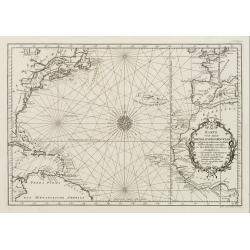
Nieuwe Wassende Graade Zee Kaart over de Spaanse Zee Vant Kanaal tot 't Eyland Cuba In Westindia.
Rare two-sheet blue-back sea chart of the Atlantic and Eastern part of North America., published by Gerard Van Keulen. The map extends from the latitude of Newfoundland a...
- $2000 / ≈ €1871
Place & Date: Amsterdam, ca. 1728-1751
Karte von dem Abendlaendischen Ocean zur allgemeinen Historie der Reise beschreibungen entworfen von Hrn Bellin..
A nice and decorative map of the Atlantic Ocean.In: Allgemeine Historie der Reisen zur Wasser und zu Lande: oder Sammlung aller Reisebeschreibungen.. in Englischen zusamm...
Place & Date: Leipzig, 1753
Selling price: $260
Sold

Karte von dem Abenlaendischen Ocean sur allgemeinen Historie der Reife beschreibungen entworfen von Hrn Bellin. . .
Map of the Atlantic Ocean with outlines of the North American continent and the European and African continents.In: Allgemeine Historie der Reisen zur Wasser und zu Lande...
Place & Date: Leipzig, 1753
Selling price: $120
Sold in 2008
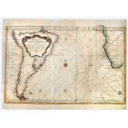
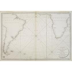
Carte réduite de l'Océan Méridional: contenant toutes les costes de l'Amérique Méridionale depuis l'Euqater jusqu' au 57 degré de latitude et les costes. . .
Map of Atlantic ocean. Showing the south-east coast of America, the south-west coasts of Africa. In the lower right the sign of the "Depôt de la Marine".Intere...
Place & Date: Paris, 1753
Selling price: $150
Sold in 2016
Carte Reduite de L' OCEAN MERIDIONAL Contenant Toutes les Costes de l' Amerique Meridionale. . .
A striking, large sea chart of the Southern Atlantic Ocean, showing most of the coast of South America and the Southwest coast of Africa, published by Nicolas Bellin. The...
Place & Date: Paris, 1753
Selling price: $145
Sold in 2019
![A NEW CHART of the Vast ATLANTIC OCEAN, Exhibiting The SEAT of WAR, both in EUROPE and AMERICA. [Popple]](/uploads/cache/83196-250x250.jpg)
A NEW CHART of the Vast ATLANTIC OCEAN, Exhibiting The SEAT of WAR, both in EUROPE and AMERICA. [Popple]
A scarce map of the Atlantic with Sailing Routes To New York & Boston. A fine example of Emmanuel Bowen's fascinating broadside map of the Atlantic, which includes a ...
Place & Date: London, 1755
Selling price: $425
Sold in 2019
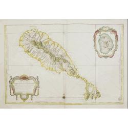
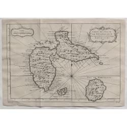
Carte Réduite De L'Isle De Saint Christophe..
A well engraved and highly detailed large-scale map of St. Kitts, with highly detailed topography , many place names, and a beautiful title cartouche. At the upper right ...
Place & Date: Paris, 1758
Selling price: $750
Sold in 2018
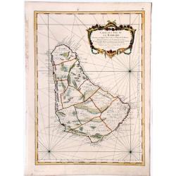
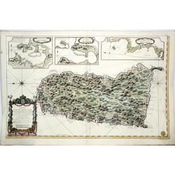
Carte de l'Isle de la Barbade.
A large engraved nautical chart,also showing the division of the Parishes, towns and fortifications. An exceptional onboard document of this rare and fabulous maritime at...
Place & Date: Paris, 1758
Selling price: $200
Sold in 2020
Carte de L'Isle de la Guadaloupe.
A fine 1758 Bellin map of Guadeloupe. Taken from a later edition of Abbe A.F. Prevost d'Exiles's "Histoire generale des voyages". It features a decorative flora...
Place & Date: Paris, 1758
Selling price: $50
Sold in 2020
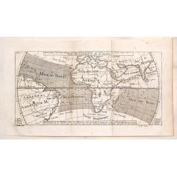
Representation du Cours Ordinaire des Vents de Traverse Qui Regnent le Long des Cotes dans la Mer Atlantique & celle des Indes.
This map shows the prevailing winds in the North Atlantic and Indian Oceans. Published in "Histoire Generale des Voyages". The engraver was Cosmant. Jacques N...
Place & Date: Paris, 1760
Selling price: $49
Sold in 2019
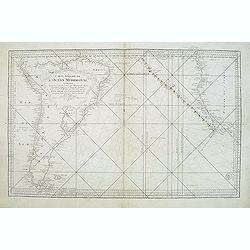
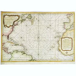
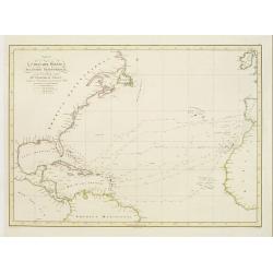
CARTE REDUITE de l' OCEAN OCCIDENTAL, Contenant les Costes Occidentales de l'Europe et de l' Afrique et les Cotes Orientales de l'Amerique . . .
This beautifully engraved chart shows the Atlantic Ocean north of the equator, delineated with rhumb lines. A good portion of each of the continents is shown with major p...
Place & Date: Paris, 1761
Selling price: $130
Sold in 2020
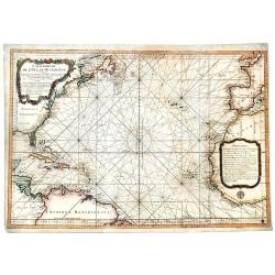
Carte Reduite de l' OCEAN OCCIDENTAL Contenant Partie des Costes d' Europe et d' Afrique... M DCCLXVI.
An decorative maritime chart, by the one of the greatest French hydrographers of the 18th century. In the context of the war at the end of the 18th century, and of the ri...
Place & Date: Paris, 1766
Selling price: $875
Sold in 2019
Carte Reduite de l'Ocean Occidental.
Superb sea chart of the Atlantic Ocean by Jacques Nicolas Bellin (1703-1772) the Royal Hydrographer and head of the Depot de la Marine, in Paris.The chart is filled with ...
Place & Date: Paris 1766
Selling price: $100
Sold
Carte Reduite de l'Ocean Occidental. . .
An attractive mid eighteenth century sea chart published in Paris by Jacques Nicolas Bellin. The chart shows from the north of South America, northwards to the Caribbean,...
Place & Date: Paris, ca 1766
Selling price: $625
Sold in 2020
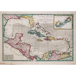
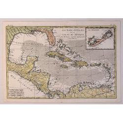
Les Isles Antiles et le Golfe du Méxique / Les Bermudes.
Rigobert Bonne (1727-1795), French cartographer. His maps are found in a.o. Atlas Moderne (1762), Raynal's Histoire Philos. du Commerce des Indes (1774) and Atlas Encyclo...
Place & Date: Paris, c. 1770
Selling price: $200
Sold
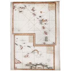
Carte générale ou l'on voit le lieu des Combats...
A very rare engraved map depicts the naval battles of René Duguay-Trouin. Two maps on one sheet. The map on the left shows the Atlantic from Spitsbergen/Svalbard until t...
Place & Date: Paris, ca. 1774
Carte Reduite des ILES ANTILLES - Carte Reduite des Debourquements de St. DOMINGUE.
A striking, large sheet with two maps of the Lesser Antilles (from the eastern tip of Puerto Rico to St. Vincent and Barbados) and of the Turks and Caicos (including part...
Place & Date: Paris, 1775
Selling price: $350
Sold in 2020
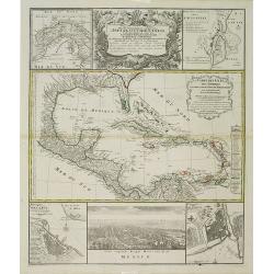
Mappa Geographica.. Indiae Occidentalis..
Six varying sized insets depict the West Indies: Panama, Saint Augustine, Vera Cruz, Santo Domingo, and a birds-eye view of Mexico City. The primary, largest inset map ha...
Place & Date: Nuremberg, 1780
Selling price: $650
Sold in 2012
Les Isles Antilles et le Golfe du Mexique.
A fine Bonne / Raynal's 1780 highly desirable map of the West Indies, Gulf of Mexico, Antilles, and Caribbean. The map extends from Florida to the Spanish Main and from M...
Place & Date: Paris, 1780
Selling price: $65
Sold in 2021
Mappa Geographica..Indiae Occidentalis..
Six varying sized insets depict the West Indies: Panama, Saint Augustine, Vera Cruz, Santo Domingo, and, a birds-eye view of Mexico City. The primary, largest inset map h...
Place & Date: Nuremberg, 1780
Selling price: $1800
Sold
Carte des Isles Antilles et du Golfe du Mexique, avec la Majeure partie de la Nouvelle Espagne. Par M. Bonne, Inge´nieur Hydrographe de la Marine. Aoust 1780. . .
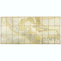
The first edition of this scarce large format map of Florida, the Gulf Coast, Texas (almost to Corpus Christi), Mexico, Baja California and Central America, northern Sout...
Place & Date: Paris, 1780
Selling price: $2200
Sold in 2022
![[Virgin Islands] Cartes De Supplement Pour Les Isles Antilles.](/uploads/cache/85495-250x250.jpg)
[Virgin Islands] Cartes De Supplement Pour Les Isles Antilles.
An excellent map of the Virgin Islands from Puerto Rico to Barbuda, centered on the American and British V.I., extending from Crab Island, St. Thomas and St. Croix to Sab...
Place & Date: Paris, 1787
Selling price: $130
Sold in 2022
Carte de L'Isle de Sainte Lucie. Dressee au Depost des Cartes et Plans de la Marine. . .
A well engraved and highly detailed nautical chart of the island of Saint Lucia in Caribbean. It shows soundings, anchorage's, channels, shoals, navigational sightings. U...
Place & Date: Paris, 1788
Selling price: $250
Sold in 2021
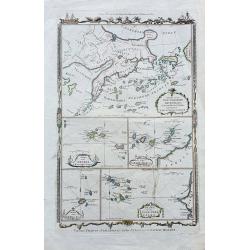
Various Charts of Islands &c. in the Atlantic & Pacific Oceans.
Five maps on one sheet: Chart of the Northern Archipelago...Kamtschatka & Anadir (with curious shaped coasts); Chart of the Azores…; Chart of the Canary Isles…; C...
Place & Date: London, c1790
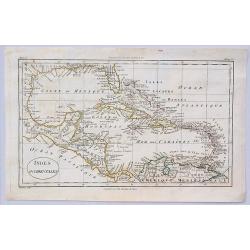
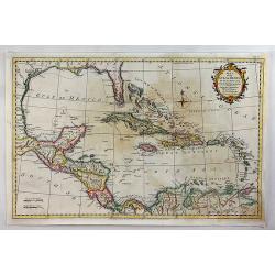
Indes Occidentales.
An antique map of the West Indies centered around Cuba with the Caribbean islands, Mexico and parts of North and South America.Jacques Blondeau (1766-1841) was a French c...
Place & Date: Paris, ca 1790
Selling price: $17
Sold in 2023
De Golf van Mexico de eilanden en het omleggende land. . .
A large map of the Gulf of Mexico and the Caribbean including the coasts of the US, Central America and the north of South America. Ii includes interesting shapes of the ...
Place & Date: Amsterdam, 1792
Selling price: $320
Sold in 2018
Map of the Gulf of Mexico, the Islands and Countries Adjacent.
A striking map of the West Indies, Gulf Coast, Florida, etc. Published in the Rev. Dr. Robertson's “History of America”. Includes a compass rose and decorative title ...
Place & Date: London, 1795
Selling price: $99
Sold in 2018
Carte générale de l'Océan Atlantique ou occidental, Dresse au depot general des Cartes Plans et Journaux/de la Marine/en 1786
Seventh edition of this magnificent sea chart of the Atlantic Ocean, covered in rhumb lines. Map flanked with extensive lists of tides, ‘Tables des Latitudes and Longit...
Place & Date: Paris, 1806
Selling price: $500
Sold in 2022
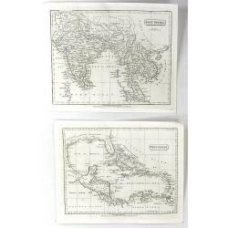
West Indies & East Indies (2 Maps)
Two separate maps published by Cadell & Davies in London in 1811. One is of the West Indies, and the other is of the East Indies. They were by John Pinkerton and are ...
Place & Date: London, 1811
Selling price: $10
Sold in 2016
Westindien.
A scarce map of South America and Caribbean. Published in “Allgemeiner Atlas” by Johann Walch (1757-1824). He was a cartographer and map publisher active in Augsburg,...
Place & Date: Augsburg, 1812
Selling price: $17
Sold in 2018
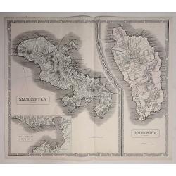
Martinico & Dominica.
Two superb maps on one sheet, of two Carribean Islands. 'Martinico' is Martinique (French) and Dominica (English). Below the Martinique map, there is an inset map of the...
Place & Date: Liverpool, 1815
Selling price: $17
Sold in 2021
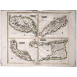
West India Islands.
Map of four islands in the Caribbean: Grenada. Tobago. Trinidad. Curacao (with) Fort Amsterdam.Title above: 'West India Islands'. At bottom centre: 'Drawn & engraved ...
Place & Date: Edinburgh, London, Dublin, 1816/1817
Selling price: $120
Sold in 2022
Carte réduite de l'océan Atlantique méridional. . .
Map showing the southern part of South America and Africa, including the Falkland islands. Issued by "Depot Général de la Marine", the official French Governm...
Place & Date: Paris, 1818
Selling price: $100
Sold in 2011
Carta del Oceano Atlantico Setentrional, con las Derrotas que siguió Dn. Cristobal Colon ..
Map of the North Atlantic Ocean, illustrating Christopher Columbus' routes to the New World in 1492, 1495, 1498, 1502.POublished by the "Deposito Hidrografico" ...
Place & Date: Madrid 1825
Selling price: $110
Sold
![Carta Di S. Domingo / Carta Delle Isole Antille. [Set of 2 maps]](/uploads/cache/45844-250x250.jpg)
Carta Di S. Domingo / Carta Delle Isole Antille. [Set of 2 maps]
Set of two maps of St. Domingo and Antilles. Size of St. Domingo is 335mm x 410mm and size of Antilles is 415mm x 340mm.From "Nuovo Atlante di Geografia Universale.....
Place & Date: Milan, Batelli, 1825
Selling price: $70
Sold in 2021