Browse Listings in America
![[Atlantic Ocean] Carta particolare dell mare Oceano fra la costa di Guinea e la Brasilia.](/uploads/cache/81883-250x250.jpg)
[Atlantic Ocean] Carta particolare dell mare Oceano fra la costa di Guinea e la Brasilia.
A large, small-scale, so-called cross-over chart of the Atlantic Ocean on two sheets. From Robert Dudley's atlas Arcano del Mare, with the coast of Africa and the eastern...
Date: Florence, 1661
Selling price: ????
Please login to see price!
Sold in 2019
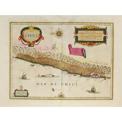
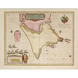
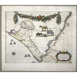
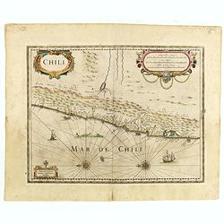
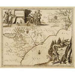
Chili.
Willem Blaeu's very decorative map of Chili with two large and beautiful cartouches, a compass and ships.First edition of the last part of the Latin "Atlas maior&quo...
Date: Amsterdam, 1662
Selling price: ????
Please login to see price!
Sold in 2010
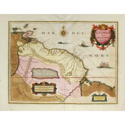
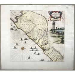
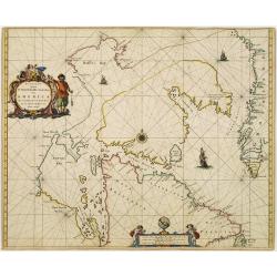
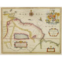
Guiana sive Amazonum Regio.
First edition of the last part of the Latin "Atlas maior" dedicated to America.Nice map extending from the Isla Margarita in the northwest to the coast of north...
Date: Amsterdam, 1662
Selling price: ????
Please login to see price!
Sold in 2009
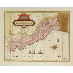
Peru.
First edition of the last part of the Latin "Atlas maior" dedicated to America.Decorated with ships and monsters on the sea. Orientated with east at the top. A ...
Date: Amsterdam, 1662
Selling price: ????
Please login to see price!
Sold in 2009
Nova et Accurata Brasiliae totius tabula.
First edition of the last part of the Latin "Atlas maior" dedicated to America. Original color.
Date: Amsterdam, 1662
Selling price: ????
Please login to see price!
Sold in 2010
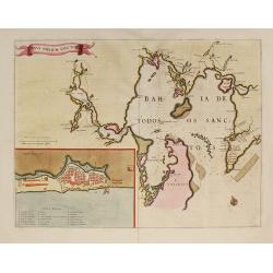
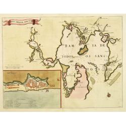
Sinus Omnium Sanctory.
Shows the area of Bahia de Todos Sanctos in north-east Brazil with an inset plan of San Salvador.First edition of the last part of the Latin "Atlas maior" dedic...
Date: Amsterdam, 1662
Selling price: ????
Please login to see price!
Sold in 2009
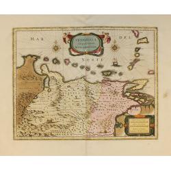
Terra Firma et Novum Regnum Granatense et Popayan.
Fine copy with wide margins of this handsome map of modern-day Panama and Colombia.First edition of the last part of the Latin "Atlas maior" dedicated to Americ...
Date: Amsterdam, 1662
Selling price: ????
Please login to see price!
Sold in 2009
Tabula Magellanica.
A map of South America's extremity with the Strait of Magellan and Le Maire Strait.The coastlines are depicted as very mountainous, while the interior is completely witho...
Date: Amsterdam, 1662
Selling price: ????
Please login to see price!
Sold in 2009
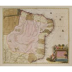
Paraquaria vulgo Paraguay.
Detailed map of Uruguay, Paraguay, Northern part of Argentina and northern part of Chilli. Engraved by Gerard Coeck. Two Dutch ships in the Atlantic Ocean.First edition o...
Date: Amsterdam, 1662
Selling price: ????
Please login to see price!
Sold in 2009
Praefecturae Paranambucae Pars Borealis. . . / Praefecturae Paranambucae Pars Meridionalis... / Praefectura de Ciriii ... / Praefecturae de Paraiba ...
Matching set of four maps covering the Brazilian Capitanias. Latin text on verso. First edition of the last part of the Latin "Atlas maior" dedicated to America...
Date: Amsterdam, 1662
Selling price: ????
Please login to see price!
Sold in 2009
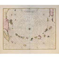
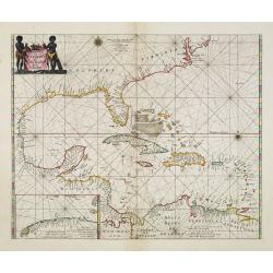
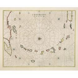
Canibales Insulae.
Rare, early Dutch nautical chart of the Caribbean from Puerto Rico southward, from the first edition of the last part of the Latin "Atlas maior" dedicated to Am...
Date: Amsterdam, 1662
Selling price: ????
Please login to see price!
Sold in 2011
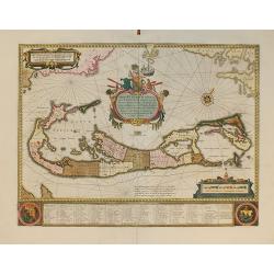
Mappa Aestivarum Insularum, alias Barmudas...
From the first edition of the last part of the Latin "Atlas maior" dedicated to America.Blaeu based his work on John Speed's remarkably accurate map of 1626-162...
Date: Amsterdam, 1662
Selling price: ????
Please login to see price!
Sold in 2010
Venezuela, cum parte Australi novae Andalusiae.
From the first edition of the last part of the Latin "Atlas maior" dedicated to America.A finely engraved, decorative map. The islands Trinidad, Margarita, Arub...
Date: Amsterdam, 1662
Selling price: ????
Please login to see price!
Sold in 2010
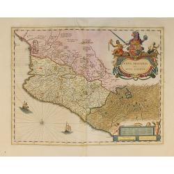
Nova Hispania et Nova Galicia.
From the first edition of the last part of the Latin "Atlas maior" dedicated to America, and based on Ortelius's map of 1579 which became the basis for many of ...
Date: Amsterdam, 1662
Selling price: ????
Please login to see price!
Sold in 2010
Freti Magellanici ac novi Freti vulgo Le Maire..
A fine map of Tierra del Fuego. With a Dutch translation of the explanatory text of the passage by Barent Jansz. Potgieter who accompanied captain Sebald de Weert to the ...
Date: Amsterdam, ca. 1662
Selling price: ????
Please login to see price!
Sold in 2016
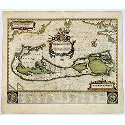
Mappa Aestivarum Insularum alias Barmudas.
Blaeu based his work on John Speed's remarkably accurate map of 1626-1627. It shows the island divided into tribes and lots, and below the map itself appear the names of ...
Date: Amsterdam, 1662
Selling price: ????
Please login to see price!
Sold in 2017
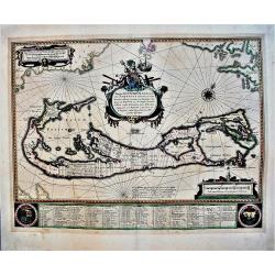
Mappa Aestivarum Insularum alias Barmudas.
An early, large, decorative map of the Bermudas by Blaeu, who based his map on the work of English cartographer John Speed, who produced a remarkably accurate map between...
Date: Amsterdam, 1662
Selling price: ????
Please login to see price!
Sold in 2021
Praefecturae Paranambucae Pars Meridionalis
Original map of the coast of Pernambuco, Brazil, from the Rio de S. Francisco to Paripueira.Title in a cartouche at top right, below is a nice scene with fishermen pullin...
Date: Amsterdam, 1662
Selling price: ????
Please login to see price!
Sold in 2022
Praefectura de Ciriji.
Full title: 'Praefecture de Ciriji vel Seregippe Del Rey cium Itapuama'. Showing a large part of the river de S. Francisco and further south to Aracaju, province of Sergi...
Date: Amsterdam, 1662
Selling price: ????
Please login to see price!
Sold in 2022
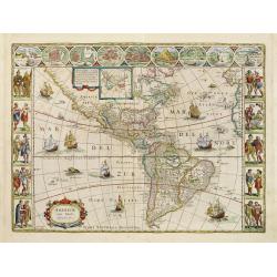
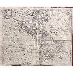
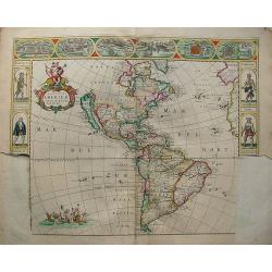
Americae Nova Tabula.
A wide paper copy, probably from his famous Atlas Major. The delineation of the coast and the nomenclature on both the Pacific and Atlantic coasts are basically Spanish i...
Date: Amsterdam, 1663
Selling price: ????
Please login to see price!
Sold in 2011

Americae nova Descriptio.
Charming little map of the North and South American continents, made by Gabriel Bucelin (1599-1681). In lower left corner part of the large southern continent "Terra...
Date: Ulm, Johannes Görlin, 1658-1664
Selling price: ????
Please login to see price!
Sold in 2008
Sinus Omnium Sanctoru. Bahia de Todos os Sanctos.
First Atlas Major issue: originally issued by Blaeu in Casper van Baarle's 'Rerum per Octennium in Brasilia' (1647) dedicated to the former Governor of the Dutch colony, ...
Date: Amsterdam, 1664
Selling price: ????
Please login to see price!
Sold in 2012
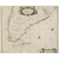
Paskaarte van Het Zuydelijckste van America..
A good copy of this scarce of the Southern tip of South America. The map also depicts a sailing ship at sea and a compass rose.
Date: Amsterdam, 1666
Selling price: ????
Please login to see price!
Sold in 2012
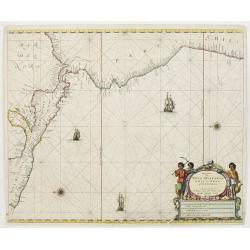
Pascaerte van Nova Hispania Chili Peru en Guatimala..
A scarce chart of southern part of Mexico, Central America, Peru and Chilli. The chart also depicts sailing ships and two compass roses.
Date: Amsterdam 1666
Selling price: ????
Please login to see price!
Sold
Chili.
Johannes Janssonius' very decorative map of Chili with two large and beautiful cartouches, a compass and ships. The modern cities of Santiago (identified on the map as &q...
Date: Amsterdam, 1666
Selling price: ????
Please login to see price!
Sold in 2012
Paskaert Zynde de Noordelijckste Zeekusten van America van Groenland door de Straet Davis en de Straet Hudson tot Terra Neuf . . .
An eye-catching chart of North America, covering the approaches to Hudson Bay and the North West Passage. Including Greenland.Pieter Goos (ca. 1616-1675) was one of the m...
Date: Amsterdam, 1666
Selling price: ????
Please login to see price!
Sold in 2021
Pascaerte van Westindien de vaste kusten en de eylanden.
A general chart of the West Indies. In the lower left-hand corner an inset (184x96mm.) of the strait between Cuba and the southernmost tip of Florida. A rare and decorati...
Date: Amsterdam, 1666
Selling price: ????
Please login to see price!
Sold in 2013
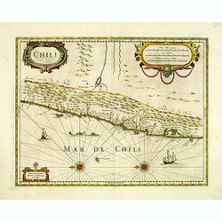
Chili.
Johannes Janssonius' very decorative map of Chili with two large and beautiful cartouches, a compass and ships. The modern cities of Santiago (identified on the map as &q...
Date: Amsterdam, 1666
Selling price: ????
Please login to see price!
Sold in 2015
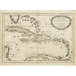
Pascaert Vande Caribes Eylanden.
A fine seventeenth century sea chart of the islands of the Caribbean, including Puerto Rico, the Virgin Islands, Barbados, Guadeloupe, Trinidad, Tobago, the Lesser Antill...
Date: Amsterdam, 1666
Selling price: ????
Please login to see price!
Sold in 2016
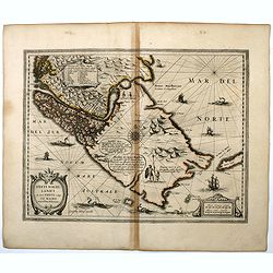
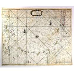
![Pascaerte van NOVA HISPANIA PERV en CHILI [California as an island].](/uploads/cache/97818-250x250.jpg)
Pascaerte van NOVA HISPANIA PERV en CHILI [California as an island].
California as an island on second Sanson model, with indented northern coast. Agubela de Cato is peninsula to its north.Possibly copied from Blaeu's map of 1648, as was D...
Date: Amsterdam, 1666
Selling price: ????
Please login to see price!
Sold in 2020
Plans des forts faicts par le régiment Carignan Salières sur la rivière de Richelieu dicte autrement des Iroquois en la Nouvelle France.
Published in François Le Mercier "Relation de ce qui s’est passé en la Nouvelle France, és années 1664 & 1665", Paris, Sébastien Cramoisy et Sébasti...
Date: Paris, Sebastien Cramoisy & Sebastien Mabre-Cramoisy, 1666
Selling price: ????
Please login to see price!
Sold in 2018
Americæ descriptio nova.
This map shows California as an island. A re-engraved version of a map previously published for Henri Seille in 1652. The map appears in Peter Heylyn's “Cosmography in ...
Date: London, 1666
Selling price: ????
Please login to see price!
Sold in 2018
Les Isles Antilles,&c.
Detailed map of the West Indies and Bahamas Islands, with southern most tip of Florida.Published in an early edition of the small Sanson atlas L'Europe Dediée a Monseign...
Date: Paris, P. Marriete, 1667
Selling price: ????
Please login to see price!
Sold in 2008
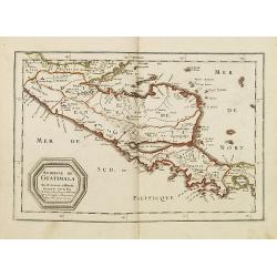
Audience de Guatimala. . .
A finely engraved map of Central America, from the Gulf of Panama and Y. de Perlas to the Southern part of the Yucatan, including the Gulf of Guanajos, the Gulf of Hondur...
Date: Paris, P. Marriete, 1667
Selling price: ????
Please login to see price!
Sold in 2011
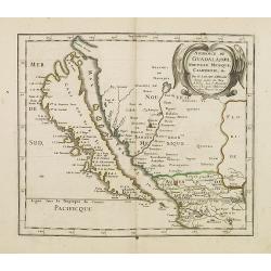
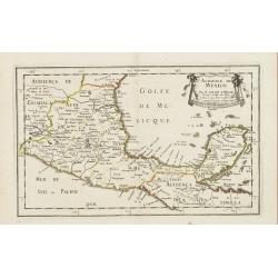
Audience de Guadalajara nouveau Mexique, Californie. &c.
A finely engraved map of California and New Mexico. Prior to this map, all maps with California shown as an Island were either World maps, Western Hemisphere, North Ameri...
Date: Paris, P. Marriete, 1667
Selling price: ????
Please login to see price!
Sold in 2016
Destroit de Magellan, Terre et Isles Magellanicques . . .
Map of the Teierra del Fuego, Magellan Detroit prepared by N.Sanson and published by Pierre Mariette.Published in an early edition of the small Sanson atlas L'Europe Dedi...
Date: Paris, P. Mariette, 1667
Selling price: ????
Please login to see price!
Sold in 2008
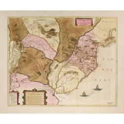
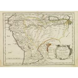
Le Paraguay . . .
Map of Paraguay prepared by N.Sanson and published by Pierre Mariette.Published in an early edition of the small Sanson atlas L'Europe Dediée a Monseigneur . . . Le Tell...
Date: Paris, P. Mariette, 1667
Selling price: ????
Please login to see price!
Sold in 2011
Audience de Mexico . . .
Map of Mexico prepared by N.Sanson and published by Pierre Mariette.Published in an early edition of the small Sanson atlas L'Europe Dediée a Monseigneur . . . Le Tellie...
Date: Paris, P. Mariette, 1667
Selling price: ????
Please login to see price!
Sold in 2010
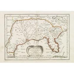
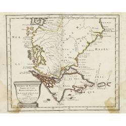
La Floride . . .
Map of Florida prepared by N.Sanson and published by Pierre Mariette.Published in an early edition of the small Sanson atlas L'Europe Dediée a Monseigneur . . . Le Telli...
Date: Paris, P. Mariette, 1667
Selling price: ????
Please login to see price!
Sold in 2008
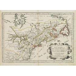
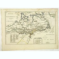
Le Canada ou Nouvelle France &c. Tirée de diverses Relations des Francois, Anglois, Hollandois &c.
Map of Canada and the Great Lakes, which would influence the cartography of the region for the next 100 years. Along with Sanson's Folio map, this map includes many first...
Date: Paris, P. Mariette, 1667
Selling price: ????
Please login to see price!
Sold in 2008
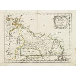
Guiane divisee en Guiane, et Caribane. . .
Map of Guinea prepared by N.Sanson and published by Pierre Mariette. This is a reduced derivative of the famous Sanson map of 1650.Published in an early edition of the sm...
Date: Paris, P. Mariette, 1667
Selling price: ????
Please login to see price!
Sold in 2008
Le Perou et le cours de la Riviere Amazone. . .
Standard map of Peru and the River Amazon prepared by N.Sanson and published by Pierre Mariette.Published in an early edition of the small Sanson atlas L'Europe Dediée a...
Date: Paris, P. Mariette, 1667
Selling price: ????
Please login to see price!
Sold in 2009
Le Bresil don't la coste est. . .
Map of Brazil. Published in an early edition of the small Sanson atlas L'Europe Dediée a Monseigneur . . . Le Tellier Secret. D'Estat &c."The ...
Date: Paris, P. Mariette, 1667
Selling price: ????
Please login to see price!
Sold in 2009
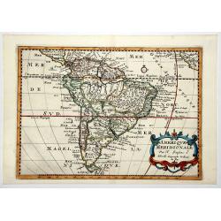
AMERIQUE MERIDIONALE.
A map of South America as prepared by N.Sanson and published by Pierre Mariette. Published in an early edition of the small Sanson atlas 'L'Europe Dediée a Monseigneur ....
Date: Paris, 1667
Selling price: ????
Please login to see price!
Sold in 2020
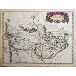
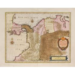
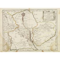
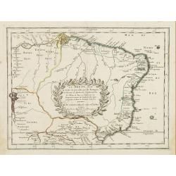
Le Paraguay Tire des Relations les Plus Recentes.
A boldly engraved, rare map of the region of present day Paraguay, Uruguay, northern Argentina, and parts of Chile and Brazil. The Rio de la Plata is the main feature of ...
Date: Paris, 1668
Selling price: ????
Please login to see price!
Sold in 2022
GUIANA sive Amazonum Regio.
Extremely rare map published by J.P. Thelott, extending from the Isla Margarita in the northwest to the coast of northern Brazil near Sao Luis east of the Amazon delta. T...
Date: Franckfurt 1669
Selling price: ????
Please login to see price!
Sold
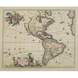
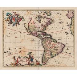
Novissima et Accuratissima Totius Americae Descriptio.
Visscher\'s map of the Americas, this decorative map greatly influenced the cartography of the Americas both geographically and artistically.Although it did not provide m...
Date: Amsterdam, 1670
Selling price: ????
Please login to see price!
Sold in 2009
Nova totius americae descriptio.
Very rare continent map of the America's. The map is not dated on the map, but it is from approx 1670.It is a rare map because it has never been issued in a regular atlas...
Date: Amsterdam, 1670
Selling price: ????
Please login to see price!
Sold in 2012
Canibales Insulae.
This is the first Dutch chart to focus on the Lesser Antilles. It covers the Windward and Leeward Isles from Puerto Rico to Trinidad and Margarita. Centered on a compass ...
Date: Amsterdam, 1670
Selling price: ????
Please login to see price!
Sold in 2019
Le Canada faict par le Sr. de Champlain. ou sont La Nouvelle France, La Nouvelle Angleterre, La Nouvelle Holande, La Nouvelle Suede, La Virginie &c. . . .
The very rare 5th state with additional place names as Boston, Manhate (Manhattan), Montreal, Quebec and Port Royal, which are not present in State 4 (circa 1664) and by ...
Date: Paris, 1670
Selling price: ????
Please login to see price!
Sold in 2012
Novissima et Accuratissima Totius Americae Descriptio.
Visscher's map of the Americas, this decorative map greatly influenced the cartography of the Americas both geographically and artistically.Although it did not provide mu...
Date: Amsterdam, 1670
Selling price: ????
Please login to see price!
Sold in 2013
Canada.
The FIRST STATE of an uncommon miniature 17th c map of Canada, the Great Lakes and the east coast of America. Published in La Monde ou la Geographie Universalle in 1670 a...
Date: Paris, 1670
Selling price: ????
Please login to see price!
Sold in 2014
Mappa Fluxus et reflxurationes in Isthmus America . . .
Very unusual map depicting all of South America and most of North America. The map is total devoid of political detail with the exception that the floating city of Mexico...
Date: Leiden, 1670
Selling price: ????
Please login to see price!
Sold in 2016
Novum Amsterodamum..
A good example of one of the earliest available views of New York, from Montanus description of America. Set in a folio page of text describing in glowing terms the attra...
Date: Amsterdam, 1671
Selling price: ????
Please login to see price!
Sold in 2011
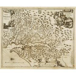
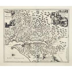
Nova Virginia Tabula.
A beautifully engraved map, derived from the highly influential map by Captain John Smith in 1612, showing Chesapeake Bay and the surrounding area. The decoration of this...
Date: Amsterdam 1671
Selling price: ????
Please login to see price!
Sold
Virginiae partis australis, et Floridae partis orientalis..
A beautifully engraved map, derived from the highly influential maps by Mercator and later Blaeu. The decoration of this finely engraved map has two entirely new cartouch...
Date: Amsterdam 1671
Selling price: ????
Please login to see price!
Sold
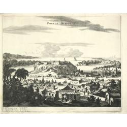
Portus Acapulco.
Arnoldus Montanus, writer of ' De Nieuwe en Onbekende Weereld: of Beschryving van America?, published by Jacob van Meurs.A beautiful, finely etched view of Acapulco.
Date: Amsterdam, 1671
Selling price: ????
Please login to see price!
Sold in 2009
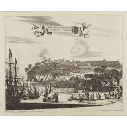
Olinda de Phernambuco.
View of the town of Olinda, north of present-day Recife in Pernambuco with extensive shipping in the foreground.This plate is taken from Ogilby's An Accurate Description ...
Date: London, 1671
Selling price: ????
Please login to see price!
Sold in 2009
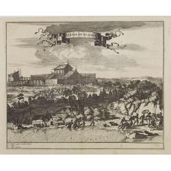
Obsidio et Expugnatio Portus Calvi.
Copper engraving of the Dutch fort at Porto Calvo (Alagoas). The foreground is filled with people, carts, and farmers. Title in banner style cartouche.This print is taken...
Date: London 1671
Selling price: ????
Please login to see price!
Sold
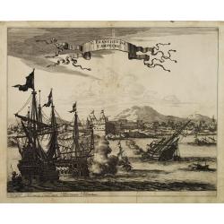
St. Francisco de Campeche.
Large view of St. Francisco de Campeche in the Yucatan with numerous warships fighting in the foreground and firing on the fort. Title ribbon in the sky.This print is tak...
Date: London, 1671
Selling price: ????
Please login to see price!
Sold in 2009
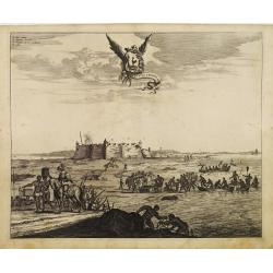
Fluvius Grandis.
A finely engraved view of a heavily armed fort along the Amazon delta. In the foreground soldiers and natives can be seen unloading goods from small boats that have come ...
Date: London 1671
Selling price: ????
Please login to see price!
Sold
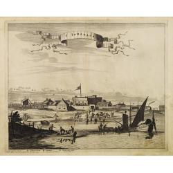
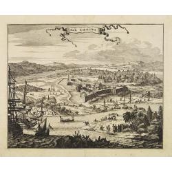
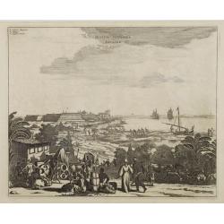
I. Tamaraca.
A superb view of the Dutch Forte Oranje on the Brazilian island of Itamaracá, with small-craft shipping and local products being hauled along the waterfront. A small let...
Date: London, 1671
Selling price: ????
Please login to see price!
Sold in 2008
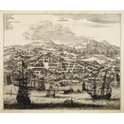
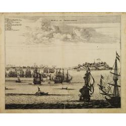
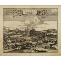
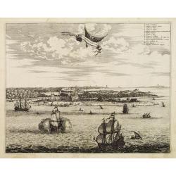
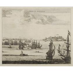
Urbs Salvador.
Fine copper engraving of the walled city of San Salvador, with numbered key at the top. Ships and boats fill the harbor in the foreground.This map is taken from Ogilby's ...
Date: London 1671
Selling price: ????
Please login to see price!
Sold
Arx Principis Guiljelmi.
Uncommon folio sheet 17th-century engraved view of the Dutch Fort William with its central church and strong palisades.Olinda is located on a hill in the background. A de...
Date: London 1671
Selling price: ????
Please login to see price!
Sold
Sinus Omnium Sanctoru.
Fine impression of Ogilby?s dramatic view of the Bay of All Saints in Brazil. Known as Sao Salvador, or Bahia, the town was first founded by the Portuguese in 1549 and wa...
Date: London 1671
Selling price: ????
Please login to see price!
Sold
Nova Virginia Tabula.
A beautifully engraved map, derived from the highly influential map by Captain John Smith in 1612, showing Chesapeake Bay and the surrounding area.The decoration of this ...
Date: Amsterdam, 1671
Selling price: ????
Please login to see price!
Sold
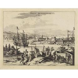
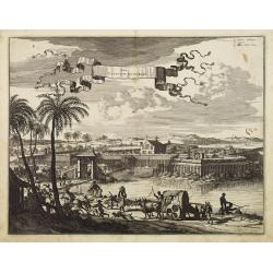
Pagus Hispanorum in Florida.
View of the port of St. Augustine, with ships and boats docked before the walled town, a few slaves and natives tending to their Spanish overlords.
Date: Amsterdam, 1671
Selling price: ????
Please login to see price!
Sold
Arx Carolina.
View of the French settlement of Charles Fort, founded 1562 on Parris Island, Carolina, named after their king Charles IX.The garrison was captured three years later by t...
Date: Amsterdam, 1671
Selling price: ????
Please login to see price!
Sold
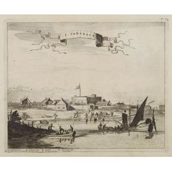
I. Tamaraca.
A superb view of the Dutch Forte Oranje on the Brazilian island of Itamaracá, with small-craft shipping and local products being hauled along the waterfront.A small lett...
Date: Amsterdam, 1671
Selling price: ????
Please login to see price!
Sold in 2008
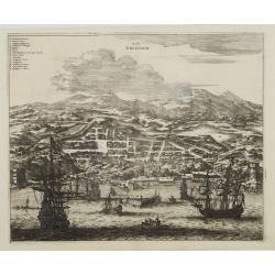
Urbs Salvador.
Fine copper engraving of the walled city of San Salvador, with numbered key at the top.Ships and boats fill the harbor in the foreground.
Date: Amsterdam, 1671
Selling price: ????
Please login to see price!
Sold
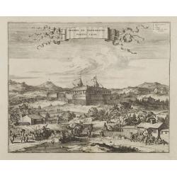
Obsidio et Expugnatio Portus Calvi.
Copper engraving of the Dutch fort at Porto Calvo (Alagoas), with numbered key in the upper right corner.The foreground is filled with people, carts, and farmers. Title i...
Date: Amsterdam, 1671
Selling price: ????
Please login to see price!
Sold
Alagoa ad Austrum.
Superb view of Alagoa (Maceio) with native fishermen in the foreground and a religious procession in the background. A small letter key at the bottom left identifies majo...
Date: Amsterdam, 1671
Selling price: ????
Please login to see price!
Sold
Ostium Flumines Paraybae.
Fine copper engraving illustrating the entrance to the Paraiba River in Brazil. With small letter key in the upper left corner.In the left background is a large fort (Cas...
Date: Amsterdam, 1671
Selling price: ????
Please login to see price!
Sold in 2008
Castrum Mauritij ad Ripam Fluminis S. Francisci.
Impressing copper engraving depicting Fort Maurice, which controlled the ferry on the Rio Francisco.With small letter key at the bottom.
Date: Amsterdam, 1671
Selling price: ????
Please login to see price!
Sold
Olinda de Phernambuco.
View of the town of Olinda, north of present-day Recife in Pernambuco with extensive shipping in the foreground.With small letter key in the upper left corner.
Date: Amsterdam, 1671
Selling price: ????
Please login to see price!
Sold
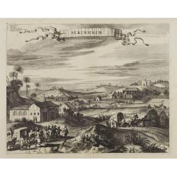
Serinhaim.
Fine view of a fort in Serinhaim, Brazil. With numbered key in the upper left corner and title enclosed in large ribbon banner style cartouche.A procession of Portuguese ...
Date: Amsterdam, 1671
Selling price: ????
Please login to see price!
Sold
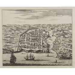
Urbs Domingo in Hispaniola.
Attractive bird's eye view of old Santo Domingo with the Cathedral, the Ozama fortress and other monuments clearly identifiable.
Date: Amsterdam, 1671
Selling price: ????
Please login to see price!
Sold
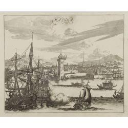
Havana.
Impressing copper engraving depicting the Havana harbour.
Date: Amsterdam, 1671
Selling price: ????
Please login to see price!
Sold
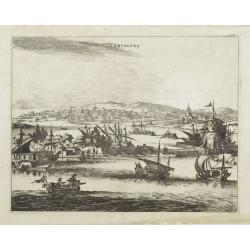
Cartagena.
Attractive view of the treasure port of Cartagena in what is now Colombia.A variety of boats and ships dominate the foreground with the town and its surroundings depicted...
Date: Amsterdam, 1671
Selling price: ????
Please login to see price!
Sold
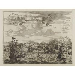
De Stadt St. Martin.
A view of the town of St. Maarten on the island St.-Martin/St. Maarten with a Dutch fleet in the foreground. Title ribbon in the sky, letter key in the upper right corner...
Date: Amsterdam, 1671
Selling price: ????
Please login to see price!
Sold