Browse Listings in Africa
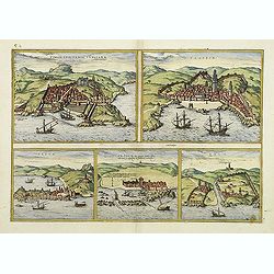
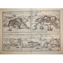
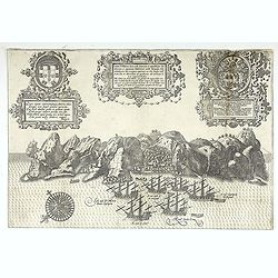
Tingis, Lusitanis, Tangiara. / Tzaffin. / Septa. / Arzilla.
Views of the five northern and western African coastal on one sheet: Latin text.From the greatest publication in this genre!. The Civitates was compiled and written by G...
Place & Date: Cologne, 1580
Selling price: $385
Sold in 2011
![[Cultivation of grapes on Madeira].](/uploads/cache/14186-250x250.jpg)
[Cultivation of grapes on Madeira].
On recto an early representation of the cultivation of grapes (58x73 mm) on the island of Madeira. On verso a representation of a dog (42x75 mm) and of an exploding volca...
Place & Date: Basle 1575-1580
Selling price: $10
Sold in 2015
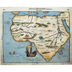
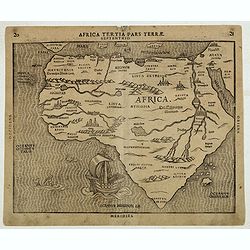
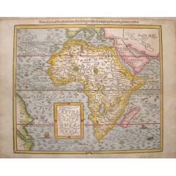
Africa tertia pars terrae.
This exceptionally decorative map, is from Heinrich Bunting's "Itinerarum Sacrae Scripturae", and is based upon the map of Africa by Sebastian Munster which app...
Place & Date: Magdeburg, ca. 1580
Selling price: $690
Sold in 2018
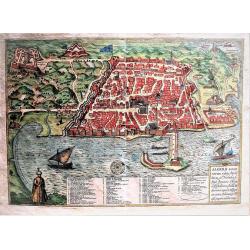
ALGERII Sarace norum urbis fortissimae.
Attractive, old colored town-plan of the city of Alger, including a numbered key legend in the lower part. From the greatest publication in this genre!. The "Civitat...
Place & Date: Cologne, 1580
Selling price: $401
Sold in 2019
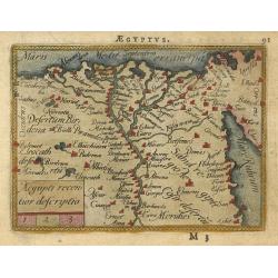
![[Lot with 12 maps of the Mediterraneans and Egypt.] Aegypti Recenttior Carthageni / General Karte des Roemischen Reichs](/uploads/cache/83963-250x250.jpg)
[Lot with 12 maps of the Mediterraneans and Egypt.] Aegypti Recenttior Carthageni / General Karte des Roemischen Reichs
A map of the Middle East and the Mediterranean. Taken from 'Algemeine Welthistorie (der Neuern Zeiten)', edited by S.J. Baumgarten, J.S.Semler a.o. Abraham Ortelius...
Place & Date: Antwerp, c. 1580
Selling price: $198
Sold in 2022
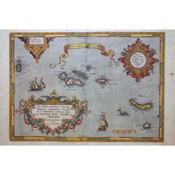
Açores Insulae.
The importance of the Azores at that time of this map was connected with the observation of Columbus that compass variation (i.e. the difference between the real and the ...
Place & Date: Antwerp, 1580
Selling price: $475
Sold in 2020
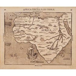
Africa Tertia pars Terrae.
This map of Africa has an unusual shape, tapering to a narrow angle in the south. Numerous rivers appear in West Africa and as tributaries to the Nile, and mountain chain...
Place & Date: Magdeburg, ca. 1581
Selling price: $1075
Sold
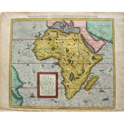
Africa tertia pars terrae.
This map, from Heinrich Bunting's "Itinerarum Sacrae Scripturae", is based upon the map of Africa by Sebastian Munster that appeared in 1540. Substantially, it...
Place & Date: Magdeburg, 1581
Selling price: $1400
Sold in 2012
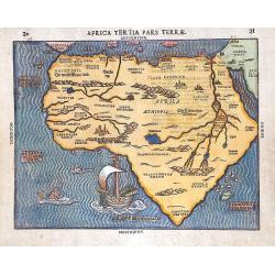
Africa Tertia pars Terrae.
This map of Africa has an unusual shape, tapering to a narrow angle in the south. Numerous rivers appear in West Africa and as tributaries to the Nile, and mountain chain...
Place & Date: Magdeburg, ca1581
Selling price: $1100
Sold in 2014
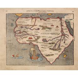
Africa Tertia pars Terrae.
This map of Africa has an unusual shape, tapering to a narrow angle in the south. Numerous rivers appear in West Africa and as tributaries to the Nile, and mountain chain...
Place & Date: Magdeburg, ca. 1581
Selling price: $475
Sold in 2018
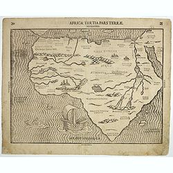
Africa Tertia pars Terrae.
This map of Africa has an unusual shape, tapering to a narrow angle in the south. Numerous rivers appear in West Africa and as tributaries to the Nile, and mountain chain...
Place & Date: Magdeburg, ca. 1581
Selling price: $600
Sold in 2019
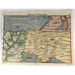
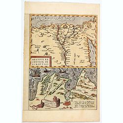
Reisen der Kinder von Israel aus Egypten.
This bold 434-year-old woodblock map illustrates the route taken by the Israelites in the Exodus from Egypt to the Promised Land. The map is very graphic with illustratio...
Place & Date: Magdenburg, 1582
Selling price: $352
Sold in 2016
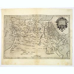
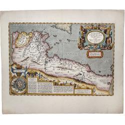
The Work of Two of History's Greatest Geographers. Morocco/ Algeria/ Tunisia/ Spain. Afr: I Tab:
A very attractive example of an early edition, the second, from Mercator’s definitive edition of Ptolemy’s geography. The map shows the area as it was known in the Ro...
Place & Date: Cologne, 1584
Selling price: $100
Sold in 2019
Africae Tabula Quarta. . .
The most general of the four Ptolemaic maps of Africa from Mercator’s definitive edition of Ptolemy’s geography. It extends far enough south to fully show Ptolemy’s...
Place & Date: Cologne, ca 1584
Selling price: $360
Sold in 2019
Aegypti recentior descriptio./ Carthaginis. . .
Two maps on one sheet. Upper part of the sheet (180 x 230 mm) is a map of the northern part of Egypt with the Nile Delta. Many small settlements are dotted along the leng...
Place & Date: Antwerp, 1584
Selling price: $60
Sold in 2020
Tingis, Lusitanis, Tangiara
A handsome five section map offering town-views of historically significant Portuguese empire North African coastal towns and entrepots, including Tangiers, Tzaffin, Ceut...
Place & Date: Cologne, ca. 1585
Selling price: $225
Sold in 2011
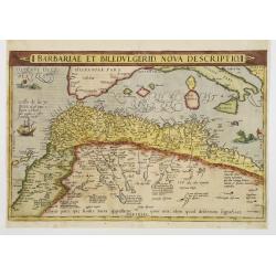
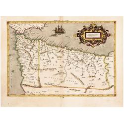
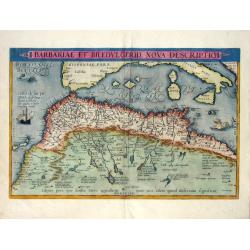
Barbariae et Biledulgerid, nova descriptio.
North-West Africa. Koeman speculated: In view of the important trading relationship between Antwerp and Africa, it is not impossible that the original was a manuscript ma...
Place & Date: Antwerp 1587
Selling price: $190
Sold
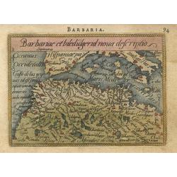
Barbariae et biledulgerid nova descriptio
Miniature map of the Barbary coast and parts of Italy and Spain. The map is beautifully engraved with stippled seas.
Place & Date: Antwerp, 1588
Selling price: $65
Sold
Aegiipti recentior descriptio
Miniature map showing the Nile valley in great detail with numerous place names. The map is beautifully engraved with stippled seas.
Place & Date: Antwerp, 1588
Selling price: $70
Sold
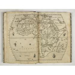
Livio Sanuto. Geografia di M. Livio Sanvto distinta in XII libri. Ne' quali, oltra l'esplicatione di molti luoghi di Tolomeo e della Bussola, ...
Livio Sanuto. Geografia di M. Livio Sanvto distinta in XII libri. Ne' quali, oltra l'esplicatione di molti luoghi di Tolomeo e della Bussola, e dell' Aguglia; si dichiara...
Place & Date: Venice, Damiano Zenaro, 1588
Selling price: $17750
Sold in 2019
Africae tabula nova / Africa, Lybia, Morenlandt, mit allen Königreichen so jetziger zeit darumb gefunden werden. . .
Attractive woodcut map showing the African continent. From the 1588-German edition of Cosmographia by Sebastian Münster. German text on verso. This woodblock map is eleg...
Place & Date: Basle, S.H. Petrie, 1588
Selling price: $350
Sold in 2014
Africae tabula nova / Africa, Lybia, Morenlandt, mit allen Königreichen so jetziger zeit darumb gefunden werden. . .
Sebastian Münster (1489-1552) is one of the most renowned cartographers of the sixteenth century, Mercator and Ortelius are considered at the same level. Munster's two m...
Place & Date: Basle, 1588
Selling price: $430
Sold in 2019
Insula D. Helenae sacra coeli dementia et aequabilitate . . .
From Linschoten, Itinerario. 3 Renaissance cartouches, 1 compass rose and many sailig ships. -
Place & Date: Amsterdam, 1589
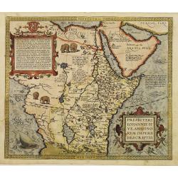
Presbiteri Iohannis, Sive, Abissin Orum Imperii Descriptio
Despite the title this map extends far beyond Prester John's supposed kingdom. It covers Africa from the fabled mountains of the moon in the center of the continent north...
Place & Date: Antwerp 1590
Selling price: $800
Sold
![Cairus, quae olim Babylon, . . . [Cairo]](/uploads/cache/60659-250x250.jpg)
Cairus, quae olim Babylon, . . . [Cairo]
Contemporaneous bird's-eye and surroundings showing the Pyramids and the Sphinx. Egypt had fallen to the Turks during the reign of Selim I at the beginning of the 16th c...
Place & Date: Cologne, 1590
Selling price: $800
Sold
![Nova Africa hoc est,recens eius inuestigatio. [North Africa]](/uploads/cache/32529-250x250.jpg)
Nova Africa hoc est,recens eius inuestigatio. [North Africa]
On verso an early map of North West Africa (123x155mm.), with on recto a small map of the island of Madeira (120x78mm.) From a Latin text edition of his Geographia , that...
Place & Date: Basle, 1550-1590
Selling price: $85
Sold in 2013
![[Afrique]](/uploads/cache/32581-250x250.jpg)
[Afrique]
On recto a strongly engraved woodblock map of the continent depicts the Nile's origins in twin lakes originating in the Motes Lunae, or Mountains of the Moon, based on Pt...
Place & Date: Basle, 1550-1590
Selling price: $120
Sold in 2013
![De Cyrene seu Cyrenaica. [Egypt and Ethiopia]](/uploads/cache/32582-250x250.jpg)
De Cyrene seu Cyrenaica. [Egypt and Ethiopia]
On recto an early wood block printed map of Egypt and Ethiopia and the Arabian Peninsular tio the right. (160xFrom a Latin text edition of his Geographia, that great comp...
Place & Date: Basle, 1550-1590
Selling price: $30
Sold in 2014
![[Egypte]](/uploads/cache/32584-250x250.jpg)
[Egypte]
On recto an early wood block printed map of Northern Egypt (176x160mm.) .From a Latin text edition of his Geographia , that great compendium of Renaissance knowledge.
Place & Date: Basle, 1550-1590
Selling price: $20
Sold in 2013
![Pyramides Aegypti. [Pyramides in Egypt]](/uploads/cache/32590-250x250.jpg)
Pyramides Aegypti. [Pyramides in Egypt]
On verso a wood block printed depiction of three pyramids in Egypt.From a Latin text edition of his Geographia , that great compendium of Renaissance knowledge.
Place & Date: Basle, 1550-1590
Selling price: $20
Sold in 2013
![[De Africae regionibus / Carthage]](/uploads/cache/32593-250x250.jpg)
[De Africae regionibus / Carthage]
On the verso an early birds-eye view of Tunis, which was the original city of Carthage (240x168mm.). The plan includes zoological and botanical gardens, castle Goleta, a ...
Place & Date: Basle, 1550-1590
Selling price: $20
Sold in 2013
![[De Africae regionibus ] Algier.](/uploads/cache/32594-250x250.jpg)
[De Africae regionibus ] Algier.
On verso an early birds-eye town-plan of Alger.From a Latin text edition of his Geographia , that great compendium of Renaissance knowledge.
Place & Date: Basle, 1550-1590
Selling price: $55
Sold in 2013
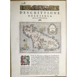
Dell ‘Isola Di San Lorenzo, Madagascar.
A beautiful map of Madagascar, from "L'Isole piu Famose del Mondo" - the most famous islands of the world by Thomas Porcacchi and engraved by Girolamo Porro. Th...
Place & Date: Padua, 1590
Selling price: $100
Sold in 2018
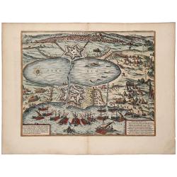
TUNES URBS ac Novae Eius Arcis et Guletae. Quae Philippo Hispan . . .
A striking old color example of Braun & Hogenberg's important early town view of Tunis. Text on verso. The image shows a siege of the port by Spanish ships under the ...
Place & Date: Cologne, 1590
Selling price: $250
Sold in 2019
Africae propriae tabula. In qua, Punica regna uides; Tyrios, et Agenoris urbem.
The most beautiful early map of the northern coast of Africa available to the collector. Prepared by Ortelius himself. A very fine example. Ortelius based this map on tha...
Place & Date: Antwerp,1590
Selling price: $360
Sold in 2020
Tabula Geogra Regni Congo
One of the most beautifully engraved maps of Africa ever produced, ornamented with numerous ships, sea monsters, and elaborate cartouches. One of few early maps to make a...
Place & Date: Frankfurt 1592
Selling price: $225
Sold
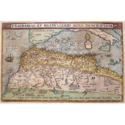
Barbariae Et Biledvlgerid, Nova Descriptio.
Attractive map of Africa by Abraham Ortelius. The map covers the area on the north-west coast of Africa from about present day Senegal and "Fume del Oro"...
Place & Date: Antwerp, (1570) 1592
Selling price: $325
Sold in 2011
Barbariae Et Biledvlgerid...
Remarkable map of Northern Africa in an early shape. Extends from Morocco and the Sahara to Libya and large parts of the Mediterranean, including the Balearic Islands, Si...
Place & Date: Antwerp, 1592
Selling price: $230
Sold in 2016
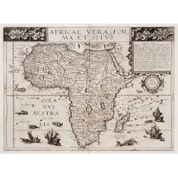
Africae vera forma et situs.
A rare map of the continent of Africa with six sea monsters and four sailing ships decorating the sea and small vignettes of natives, some with bow and arrow, others with...
Place & Date: Antwerp 1593
Selling price: $4425
Sold
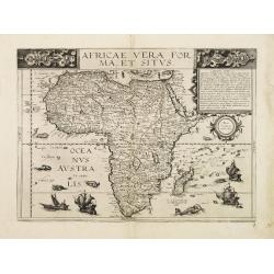
Africae vera forma ey situs.
A rare map of the continent of Africa with six sea monsters and four sailing ships decorating the sea and small vignettes of natives, some with bow and arrow, others with...
Place & Date: Antwerp 1593
Selling price: $5600
Sold