Browse Listings in World Maps
![Shintei Bankoku Zenzu [Revised Comprehensive Map of All Countries]](/uploads/cache/48437-250x250.jpg)
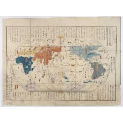
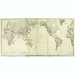
Shintei Bankoku Zenzu [Revised Comprehensive Map of All Countries]
Compiled by Kageyasu Takahashi, the finest world map of the Edo period, copper plate print, 1810. Bunka 7 is dated from the preface on this map,This world map, published ...
- $26000 / ≈ €24329
Place & Date: Kyoto, Bunka 7 or 1810

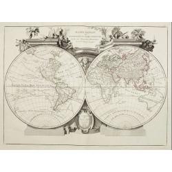
A new and correct map of the world.
The early eighteenth century was one of the most important periods for English cartography. One of the period's most intriguing world maps is this large-scale map which o...
- $12000 / ≈ €11229
Place & Date: London 1714
![[Ritter Sundial Map of the World]](/uploads/cache/60731-250x250.jpg)
[Ritter Sundial Map of the World]
This highly unusual map projects the world from the north pole as though it were the table of a sundial, with the land masses drawn to scale in proportion to their distan...
- $4500 / ≈ €4211
Place & Date: Nuremberg, 1640
Chikyu Bankoku sankai yochi zenzu setsu. / Sekisui Cho Harutaka. (Map and description of geography of all the countries of the globe).
Reduced version of the famous map "Kaisei chikyu bankoku zenzu" by Sekisui Nagakubo (1717-1801) published ca. 1785, still based on the one by Matteo Ricci. Incl...
- $3500 / ≈ €3275
Place & Date: Tokyo, 1850

The Pathways of Empire Delineated: Map Showing The Steam Comunication And Overland Routes between England, India, China & Australia…
An illuminating and attractive map that illustrates one of the foundations of British imperial power--the key trade routes by both land and sea between England and its fa...
- $3000 / ≈ €2807
Place & Date: London, 1856
Mappemonde Dressée sur les Relations les Plus Nouvelles et les plus approuvées assujeties aux Obserations de Mrs. De L'Académie Royale des Sciences.
Dated 1761, this state is unknown. "Desnos' includes a fine combination of up to date cartographic information and the routes of important 18th century voyages of ex...
- $3000 / ≈ €2807
Place & Date: Paris, 1789
Planisfero del Mondo Vecchio. . .
A decorative map of the Eastern hemisphere includes Abel Tasman's discoveries in Australia. The decorative borders include coordinates and descriptions of signs of the zo...
Place & Date: Venice, 1691
Selling price: $1800
Sold in 2015
Orbis terrarum typus de integro in plurimis emendatus auctus et icunculis illustratus.
Outstanding and rare example of a bible world map based on the Visscher bible map from 1657 (Shirley 401/414). This map is larger in size and has an extra engraved frame ...
- $2000 / ≈ €1871
Place & Date: Minden, 1729
Mappa Monde ou description du globe terrestre . . .
Double hemisphere world map. California is not an island anymore, but a large Mer de l'Ouest is shown. Delineation between New Holland (Australia) and New Guinea is not y...
- $2200 / ≈ €2059
Place & Date: Venice, 1776 - 1784
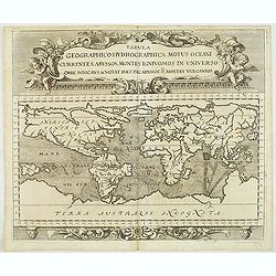
Tabula geographico-hydrographica motus Tom II p.132.
World map depicting ocean currents, volcanoes and deep-sea chasms. The continents are void of political detail and only major lakes, rivers and volcanoes are shown. There...
- $2000 / ≈ €1871
Place & Date: Nuremberg, 1696
Descrizione del Globo in due emisferi . . .
This large-format map is finely engraved and beautifully colored and was prepared by Girolamo Petri, a lawyer who served as a senior official within the Vatican’s State...
- $1750 / ≈ €1638
Place & Date: Rome, 1858
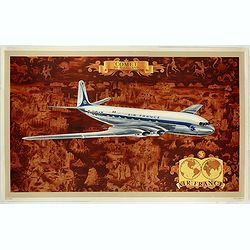
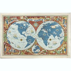
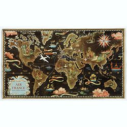
AIR France - Comet De Havilland
Promotional poster attributed to Lucien Boucher showing the Comet de Havilland on a Mercator projection world map. The map depicts a pictorial map of the entire world in ...
- $1600 / ≈ €1497
Place & Date: Perceval, Paris, 1953
![[Horological diagrams surrounding a smaller world map]](/uploads/cache/45027-250x250.jpg)
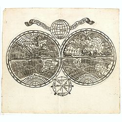
[Horological diagrams surrounding a smaller world map]
This beautiful engraving has nine (of ten) horological diagrams surrounding a smaller map, which omits any delineation of the British Isles. Projected from the North Pole...
- $2000 / ≈ €1871
Place & Date: Nuremberg 1640
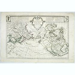
Carte des nouvelles decouvertes au Nord de la Mer du Sud.
Although concentrating on the northern Pacific, this map shows all of North America and Mexico.While the Russian coastline is shown with reasonable accuracy, notwithstand...
- $1800 / ≈ €1684
Place & Date: Venice, 1776 - 1784
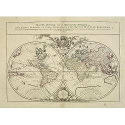
Mappe-Monde Geo-Hydrographique, ou Description Générale. . .
Large map of the world in two hemispheres, in a stereographic projection (each hemisphere 31.5 cm in diameter). California seems to be connected to the mainland, rather t...
Place & Date: Paris, 1719, but ca. 1741-1745
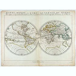
Mappe-Monde, ou Carte Generale du Monde: Dessignée en deux plans Hemispheres Par le Sr. Sanson d'Abbeville, Geographe ordinaire de sa Majesté.
First state of Sanson's first map of the World. Sanson's first world maps, dated 1651 and 1652, were issued separately and then in collections of maps. The map is one of ...
- $1500 / ≈ €1404
Place & Date: Paris, 1651
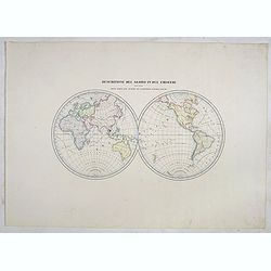
![Die Obere oder Nordliche Halbkugel der Erde auf den Horizont von Wien, Sterographisch Entworfen ... [together with] Die Untere oder Sudliche Halbkugel der Erde auf den Horizont von Wien, Stereographisch ...](/uploads/cache/39377-250x250.jpg)
Die Obere oder Nordliche Halbkugel der Erde auf den Horizont von Wien, Sterographisch Entworfen ... [together with] Die Untere oder Sudliche Halbkugel der Erde auf den Horizont von Wien, Stereographisch ...
A set of two uncommon large format maps of the Northern and Southern Hemisphere, based upon the work of Johann Anton Ecker (1755-1820). First published in 1794, this is t...
- $2000 / ≈ €1871
Place & Date: Vienna, Phil. Jos Schalbacher, 1800
![Tutte le strade conducono a Roma. [All roads lead to Rome]](/uploads/cache/44998-250x250.jpg)
Tutte le strade conducono a Roma. [All roads lead to Rome]
Game board of the game "All roads lead to Rome" from the Fascist era, offered by the chocolate or cocoa company Talmone-Unica. Showing a world map surrounded by...
- $1500 / ≈ €1404
Place & Date: Turin, 1928
Description de nouveau pasage vers le zud.... together with an untitled map of Port Desire (today's Puerto Deseado, Argentina)
Rare double hemispherical world map showing the track round the world by Le Maire and Schouten in 1615-1617. Continents are marked in outline and no southern regions are ...
- $1500 / ≈ €1404
Place & Date: Frankfurt, M.Merian, 1631
Planiglobii Terrestris Mappa Universalis.. - Mappe-Monde qui represente les deux Hemispheres. . .
Word map in double hemisphere. In center two smaller hemispheres of the north and south pole are shown. Two interesting diagrams depict the earth as it would be seen from...
- $1750 / ≈ €1638
Place & Date: Nuremberg, 1746
![Jules Verne. Le Tour du Monde en 80 jours. [Goose game board inspired by Jules Verne's novel Tour du Monde en 80 jours.]](/uploads/cache/44962-250x250.jpg)
Jules Verne. Le Tour du Monde en 80 jours. [Goose game board inspired by Jules Verne's novel Tour du Monde en 80 jours.]
This Goose game board is inspired by Jules Verne's novel whose boxes are illustrated with town views and figures and the center is occupied by a world map. Vignette illus...
- $1100 / ≈ €1029
Place & Date: Paris, 1876
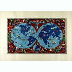
Sur les ailes d'Air France découvrez le monde à votre tour.
Promotional mid-size poster of a double hemisphere world map designed by Lucien Boucher for AIR France. The map depicts the entire world in rich blues and burgundies with...
- $1100 / ≈ €1029
Place & Date: Imprimerie Goosens, Paris, 1952
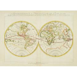
L'Hydrographie ..la Surface du Globe Terrestre.
An unusual double hemisphere hydrological map of the world - the earliest of the world prepared by the great French mapmaker Nicolas Sanson. Of particular interest is the...
- $750 / ≈ €702
Place & Date: Paris, 1652

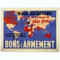
Nous vaincrons parce que nous sommes les plus forts. Souscrivez aux bons d'armement.
"We win because we are the strongest. Support good armaments". Quote by the French Prime Minister Paul Reynaud. French wartime propaganda poster. color printed ...
Place & Date: Paris, M.Dechaux, ca 1939
Selling price: $105
Sold in 2019
AIR France - Sur les ailes d'Air France découvrez le monde à votre tour.
Promotional poster of a double hemisphere world map designed by Lucien Boucher for AIR France. The map depicts the entire world in rich blues and burgundies with gold hig...
Place & Date: Perceval, Paris, 1952
AIR France réseau arérien mondial.
Original lithograph advertising planisphere cardboard from AIR France. The map is designed by Lucien Boucher and is in fact a reduced version of his larger format poster....
- $800 / ≈ €749
Place & Date: Imprimerie Perceval, Paris, 1938
The world, including the discoveries made by Capt. Cook.
Uncommon double-hemisphere world map depicting the voyages and discoveries of Captain James Cook. There are numerous notations throughout and the tracks of Cook's three v...
- $1000 / ≈ €936
Place & Date: London, 1781
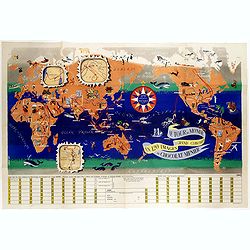
Le tour du monde en 120 images, grand concours du Chocolat Menier.
Pictorial map of the world centered on the Pacific with a route around the globe, starting and finishing in Paris. The map features 120 images of explorers, plants, anima...
- $750 / ≈ €702
Place & Date: Paris, 1956
Orbis Terrae compendiosa descriptio.
Modern world map by Rosaccio, consisting of two hemispheres enclosed within a plain border. The engraving is sharp and neat, and is a skilful reduction of Rumold Mercator...
- $1000 / ≈ €936
Place & Date: Venise, 1598/1713
Planisphère terrestre.
A huge (2 meters) world map representing Asia and America in the center, Europe and Africa at left and right hand of the map. Published by the Service hydrographique in 1...
- $800 / ≈ €749
Place & Date: Paris, Service hydrographique, 1902-1914
![[TAI travel poster]](/uploads/cache/44893-250x250.jpg)
[TAI travel poster]
A whimsical travel poster for "Transport Aeriens Intercontinentaux" (TAI), published in Paris in 1960, by Luc-Marie Bayle (1914-2000). The poster depicts a twin...
- $700 / ≈ €655
Place & Date: Paris, 1960
Novo Globo Terraqueo.
Double hemisphere world map with a broad banner carrying the title. In the ocean are currents shown and in top and bottom are diagrams showing the zones. A rare map.
- $750 / ≈ €702
Place & Date: Italy, ca. 1755
Abbozzo della mappa dei viaggi di Marco Polo nella sala dello Scudo del Palazzo ducale di Venezia.
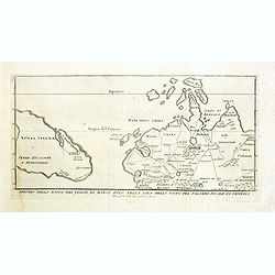
Rare map showing the travels of Marco Polo, taken from "Sulle antiche mappe idro-geografiche lavorate in Venezia: Commentario.", by Placido Zurla (1769-1834), p...
Place & Date: Venice, 1818
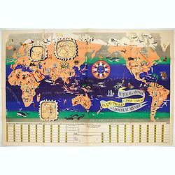
Le Tour du Monde en 120 Images Grand Concours du Chocolat Menier.
This highly unusual and rather novel pictorial map of the world was created by J.B. Jannot and published by Agence Française de Propagande as a promotional item for Meni...
Place & Date: Paris, 1956
Nous vaincrons parce que nous sommes les plus forts. Souscrivez aux bons d'armement.
We win because we are the strongest. Support good armaments". Quote by the French Prime Minister Paul Reynaud. French wartime propaganda poster. colored world map - ...
- $600 / ≈ €561
Place & Date: Paris ca 1939
![[Board game] - La course autour du Monde.](/uploads/cache/48521-250x250.jpg)
[Board game] - La course autour du Monde.
Very rare French board game - no other copies known. The game consists of 50 fields linked to the lines of longitude. A globe lies in the center of the board to symboli...
Place & Date: Paris, ca. 1900
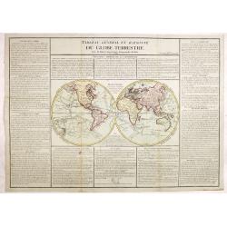
Tableau général et raisonné du Globe Terrestre. . .
Uncommon double hemisphere world map showing the tracks of Cook (1771-73, 1771 and Clarcke (1779). Surrounded by geographical information for each continent along with us...
- $1000 / ≈ €936
Place & Date: Paris 1792
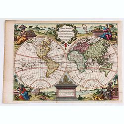
Mappe Monde qui Comprend les Nouvelles..
Charming double hemisphere map with the female representations of the continents adorning each corner published by George Louis Le Rouge, active in Paris 1740-1780 .The N...
- $600 / ≈ €561
Place & Date: Paris, 1748
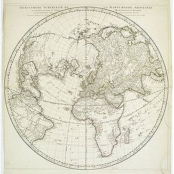
Hémisphère Supérieur de la Mappemonde projetée sur l'Horizon. . .
Hemisphere on a partial polar projection. The Northern Hemisphere (of 2) is centered on Paris emphasizing the continents. Hemisphere measures 24.5. Alaska is shown as an ...
Place & Date: Paris, 1774
![Mappa Mondo tagliato sulpiano di unmeridiano Emisfero Occidentale. [togther with] … Orientale.](/uploads/cache/48543-250x250.jpg)
Mappa Mondo tagliato sulpiano di unmeridiano Emisfero Occidentale. [togther with] … Orientale.
World map on two sheets - Western Hemisphere (North and South America, Oceania, Greenland) and Eastern Hemisphere (Europe, Africa, Asia, Australia). Published by Pazzini,...
- $500 / ≈ €468
Place & Date: Siena, 1796