Browse Listings in Europe > Netherlands > Gelderland > maps
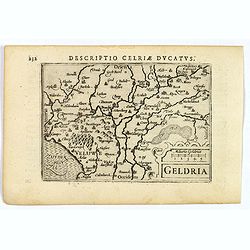
Geldria.
An original early 17th century copper engraved miniature antique map of the Dutch province of Gelderland by Petrus Bertius, that was published in Amsterdam at the beginni...
- $100 / ≈ €87
Date: Amsterdam, 1606
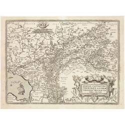
Gelriae, Cliviae, Finitimorumque Locorum Verissima Descriptio.
From the very rare Galle edition of the Ortelius Atlas, published after 1612. Fine map of Geldria and Limburg, prepared by Christian s'Grooten. Very fine title cartouche ...
$1250 / ≈ €1092
Date: Antwerp, after 1612
![Lovenstein. [Loevestein]](/uploads/cache/13749-250x250.jpg)
Lovenstein. [Loevestein]
View of the castle Loevestein, near Gorinchem.. On the sky, three hands holding a quill, a stone and a stick are depicted. With a verse in two languages underneath the pi...
- $60 / ≈ €52
Date: Frankfurt, 1624
