Browse Listings in Europe > Mediterranean & Islands > Majorca / Minorca
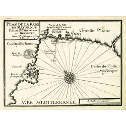
Plan de la Rade de Mayorque.
An attractive chart centered on Palma de Majorca in the Mediterranean. With scale and large compass-rose. Dated 1727, with the privilege of the King. From : Recueil des P...
- $600 / ≈ €524
Date: Marseille, 1730
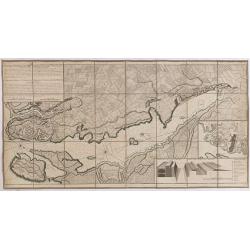
Plan de la Ville et du Port Mahon et du Fort St. Philippe..
Uncommon folding-map of the fort and town St.Philippe and port Mahon. In upper left corner a key in French (A-Z, Aa-Bb) and a key in Spanish (A-Z, Aa-Oo).A first state. A...
- $800 / ≈ €699
Date: Paris, 1756
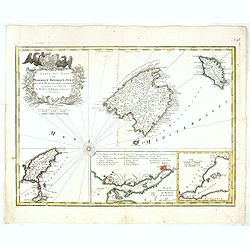
Carte des Isles de Maiorque Minorque et Yvice.
Uncommon map of Majorca, Minorca and Ibiza prepared by J.N. Bellin. With an inset plan of the harbor of Mahon "Plan du Port et de la Ville de Mahon", and a seco...
- $700 / ≈ €611
Date: Nuremberg, 1756
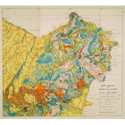
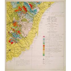
Mapa geologic de les serres de Llevant de l'illa de Mallorca.
Geological map showing part of the island Mallorca Manacor, Son Severa, Capdepera.. After a design by D.Ferrá. Dibuxá, in lower right corner: D.Ferrà. Dibuxá.Provenan...
- $150 / ≈ €131
Date: Palma, 1932
Mapa geologic de les serres de Llevant de l'illa de Mallorca.
Geological map showing part of the island Mallorca Felanitx, Santanyi, Porto Cristo, Porto Colom.., including a legend with geological and topographical signs. After a de...
- $100 / ≈ €87
Date: Palma, 1932
