Browse Listings in Asia > South East Asia > South East Asia general
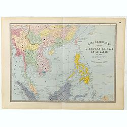
Carte de l'Asie orientale comprenant l'empire chinois le Japon les états de l'Indo-Chine et le grand archipel d'Asie ou Malaisie.
Detailed map of Malaysia, Thailand, China, Taiwan, and good detail in Philippines. Lower part of a 2-sheet map.
Date: Paris, 1862

Carte générale de la mer des Indes dressée par P. Daussy et P.E. Wissocq, grave par Chassant, ecrit par J.M. Hacq.
Magnificent and detailed large-scale chartdepicting the Indian ocean, with east coast of Africa, Madagascar, Arabian Peninsula, India, China, etc .Including the West coa...
- $1000 / ≈ €868
Date: Paris, 1837-1869
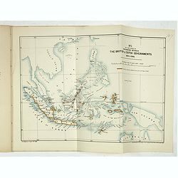
Papers relating to the affairs of Sulu and Borneo, and to the grant of a charter of incorporation of the British North Borneo Company. . . (with two folding maps of Indonesia)
58 pages Government recordings relating to the affairs of Sulu and Borneo, and to the grant of a charter of incorporation of the British North Borneo Company. . . (includ...
- $500 / ≈ €434
Date: London, Harrison and son, 1882
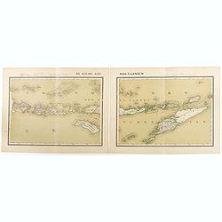
De kleine Soenda-Eilanden. Schaal van 1:800000.
Very detailed two sheet map of Soenda Islands, taken from "Atlas van Nederlandsch Oost- en West-Indie", prepared by doctor I. Dornseiffen, and published by publ...
- $30 / ≈ €26
Date: Amsterdam, Seyffardt, 1884
![[Title page] Der Nederlandsche Bezittingen in Oost-Indië . . .](/uploads/cache/37336-250x250.jpg)
[Title page] Der Nederlandsche Bezittingen in Oost-Indië . . .
Decorative title page with, in the lower part, a schematic map of Indonesia, and two hemispheres. Taken from "Atlas der Nederlandsche bezittingen in Oost-Indië"...
- $75 / ≈ €65
Date: The Hague, 1883-1885
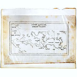
Hayter Basilisk, and Moresby Islands. (manuscript map)
An unusual small, and basic manuscript map of the Hayter Basilisk and Moresby Islands near Papua New Guinea, off the northern coast of Australia.
- $100 / ≈ €87
Date: London, ca. 1890
![Daily Telegraph War Map of The Far East. [No.11]](/uploads/cache/42244-250x250.jpg)
Daily Telegraph War Map of The Far East. [No.11]
A large and very detailed map of The Far East "Specially drawn for the Daily Telegraph by 'Geographia' Ltd". Printed in full color. Map extends from the norther...
- $125 / ≈ €108
Date: London, ca. 1940
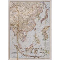
The Far East Compiled and Drawn in the Cartographic Section of the National Geographic Society for the National Geographic Magazine Gilbert Grosvenor. . .
Map of Far East Asia, with inset map of Korea. Scale 1:7.500.000. The first issue of National Geographic Magazine was published on September 22, 1888, nine months after t...
- $75 / ≈ €65
Date: Washington, 1952