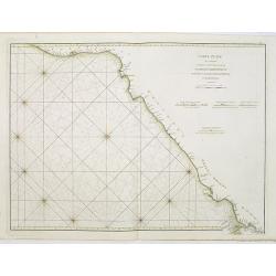
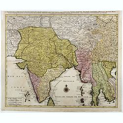
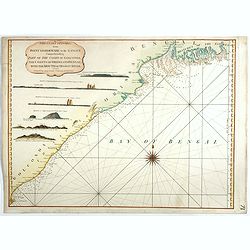
Carte Plate qui comprend La partie septentrionale de LA Cöte de Coromandel et les Côtes de Golconde , D' Orcha et de Bengale.
French chart of Coromandel in India. West to the top.Latitude and longitude scales, compass rose and system of rhumb lines, soundings near coast and in bay areas.D' Aprè...
- $150 / ≈ €131
Date: Paris, Brest, chez Demonville, 1775

Carte de la Baye et du Port de Trinquemalay dans L'Isle de Ceylan.
Chart showing the bay of Trincomalee, Ceylon (Sri Lanka). Trincomalee is natural deep water port on the east coast of Sri Lanka, about 110 miles northeast of Kandy. It is...
- $250 / ≈ €218
Date: Paris, 1775
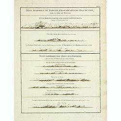
Vues diverses du fort de l'Agouade pres de l'isle de Goa . . . Sumatra . . .
French sea sea chart with 9 coastal views near Goa in India and Sumatra. The titles above the main profiles reading as following : Vues diverses du fort de l'Agouade pre...
- $200 / ≈ €175
Date: Paris, Brest, Demonville, 1775

Carte de la Baye et du Port de Trinquemalay Dans L'Isle de Ceylan.
French chart of the harbor of Trinquemalay on the island of Ceylon. Prepared after Samuel Cornish who was a vice admiral for the English East India company.Latitude and l...
- $350 / ≈ €306
Date: Paris, Brest, chez Demonville, 1775
![The country Coromandel from the Coleroon to Cape Comorin. . . [with] The carnatic from the Pennar to the Coleroon. .](/uploads/cache/48363-250x250.jpg)
The country Coromandel from the Coleroon to Cape Comorin. . . [with] The carnatic from the Pennar to the Coleroon. .
Coromandel from the Coleroon to Cape Comorin. Elegant map in two sheets compiled for the East-India Company. In lower right margin : Writing by W. Harrison.
- $300 / ≈ €262
Date: London, 1778
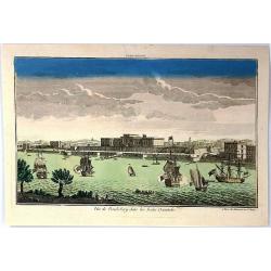
Vue de la Pondichery dans les Indes Orientales
Pondicherry is the capital city of Indian union territory of Puducherry. Pondicherry is situated in Puducherry district of the union territory in India. The vue was produ...
Date: Paris, 1780
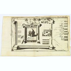
Madirass. Ville Indienne don't les Maisons sont basses & plates.
A small plan of Fort St. George, Madras/Chennai in India. It highlights both inner and outer fortifications, fences, town entrances and the sea, together with the church,...
Date: Unknown, ca 1780
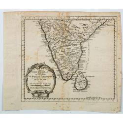
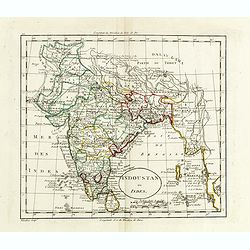
Carta Dell' Indostan che comprende il Malabar, Coromandel, e tutta la penisola Dell' India.
This is from a scarce Italian edition of French cartographer Jacques-Nicholas Bellin’s map of southern India and the island of Ceylon (Sri Lanka). The map extent is fro...
Date: Paris, ca 1780
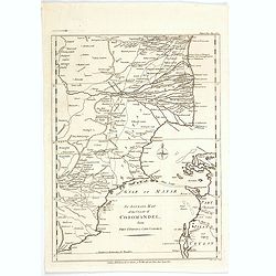
An Accurate Map of the Coast of Coromandel, from Fort St. David to Cape Comorin.
This is a finely engraved map of the south eastern Indian Coromandel coastal regions & the north west Sri Lankan coast through the Gulf of Manar. It was engraved by J...
Date: London, 1782
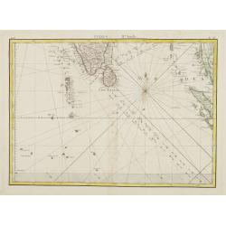
Indes. IIe. Feuille.
Attractive map of the southmost tip of India and Sri Lanka, including the Maldives and part of Sumatra. Boundaries are outlined in hand color.From the "Atlas moderne...
Date: Paris ca 1783
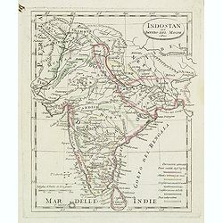
Partie de la nouvelle grande carte des Indes Orientales. . .
This is the northwest sheet of a four-sheet map of Southern and Southeast Asia, showing the Bay of Bengal and extending from the Pakistani border across India to the Indo...
Date: Amsterdam, 1792
The Coast of India, from Point Gordeware to the Ganges Comprehending Part of the Coast of Golconda . . .
Detailed sea chart of the coast of India, from the mouths of the Ganges Rivers in the northeast to Point Gordeware in the south west. Includes numerous sailing channels a...
- $400 / ≈ €349
Date: London, 1794
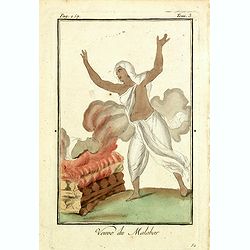
Venue du Malabar.
Originally hand-colored mezzotint of a widow of Malabar engraved by Félix Mixelle and Lachaussée Jeune after Jacques Grasset de Saint-Sauveur.As an etcher, drawer and w...
Date: Paris,1801-1806
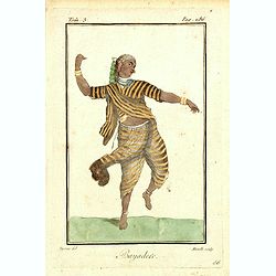
Bayadere.
Originally hand-colored mezzotint of a Temple Dancer engraved by Félix Mixelle and Lachaussée Jeune after Jacques Grasset de Saint-Sauveur.As an etcher, drawer and writ...
Date: Paris,1801-1806
Charte von Ostindien disseits des Ganges im gegenwärtigen Zustande.
A uncommon issue of this detailed map of India, including Ceylon.
Date: Weimar, 1807
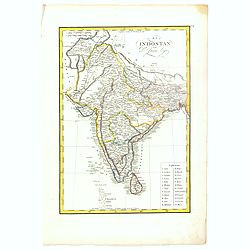
Indoustan ou Inde.
Map of India. The map is based on the Paris Meridian, only in 1884, at the International Meridian Conference in Washington DC, the Greenwich Meridian was accepted.Engrave...
- $100 / ≈ €87
Date: Paris, c. 1810
El Indostan por D. Juan Lopez.
Uncommon map of India and Shri Lanka published by Juan Lopez (1765-1830) and included in his "Atlas Universal o collection de mapas nuevos. . ." first published...
Date: Madrid, 1817
Indostan gia impero del mogol. . .
Charming map of India with Ceylon from the rare atlas Atlante Tascabile o sia Serie di Num. XXI Cartine Geografiche nelle quali si rappresenta in ristretto lo Stato Attua...
- $150 / ≈ €131
Date: Rome, 1823
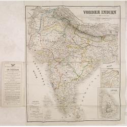
Vonder Indien.
Map of India with two inset maps, one of Upper Asam, and the other of Ceyland.
Date: Weimar, 1822-1825
![[Mongolian pipe smoking ].](/uploads/cache/26258-250x250.jpg)
[Mongolian pipe smoking ].
Aquatint depicting a group of Mongolians in traditional attire during a pipe smoking ceremony. Chinese and Mongolian tradition had tobacco smoking from pipes with small m...
- $80 / ≈ €70
Date: Milan, 1827
![[ LXXII. Divertimenti de' serpenti ].](/uploads/cache/34981-250x250.jpg)
[ LXXII. Divertimenti de' serpenti ].
Aquatint depicting snake charmers engraved by D.Klemi-Bonatti, Plate N°60.From Giulio Ferrario's work Le Costume Ancien et Moderne ou Histoire du gouvernement, de la mil...
- $50 / ≈ €44
Date: Milan, 1827
![[British soldiers in India].](/uploads/cache/14500-250x250.jpg)
[British soldiers in India].
A decorative print showing a group of English soldiers being attacked by Indian locals. After design of A. van Eschen. From a series Englischer Dienst. 10 Service d'Angle...
Date: Germany, c.1830
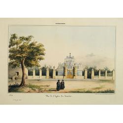
Pondichery - Vue de l'Eglise des Jésuites.
Constructed in 1791, it is regarded as the main mother church of Roman Catholic Archdiocese of Pondicherry and Cuddalore. To one’s surprise, this famous church in Pondi...
- $300 / ≈ €262
Date: Paris, 1843
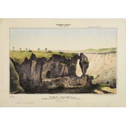
Southern - Concan.. - Nalkind or Kates Point..
Lithography representing a rocky landscape in the Western Ghats. Plate N° 12. From Souvenirs d'un voyage dans l'Inde, exécuté de 1834 à 1839, by A. Delessert.Adolphe ...
- $300 / ≈ €262
Date: Paris, 1843
![[7 Indian Patna water colors of crafts.]](/uploads/cache/43663-250x250.jpg)
[7 Indian Patna water colors of crafts.]
Seven Company school, also called Patna painting, style of miniature painting that developed in India in the second half of the 18th century in response to the tastes of ...
- $750 / ≈ €655
Date: India, ca.1850
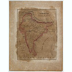
L'India e L'Isola di Seilan.
Uncommon map of India prepared by Francesco Costantino Marmocchi. Above the map "Geografia Commerciale". From "Il Globo Atlante di carte Geografiche compil...
Date: Genova, Paolo Rivara fu Giacomo, 1858

Vicariati E prefetture apostoliche nelle Indie Orientalis
Map showing the boundaries of Catholic dioceses in South and Southeast Asia in 1850s, with some detail of India, Malacca, Thailand and Hainan. This finely engraved and be...
- $500 / ≈ €437
Date: Rome, 1858-1859
![(2 charts of Shri Lanka) Mer des Indes - Ile de Ceylan - Partie Nord. Détroit de Palk et Golfe de Manaar.. [with] Partrie Sud...](/uploads/cache/23493-250x250.jpg)
(2 charts of Shri Lanka) Mer des Indes - Ile de Ceylan - Partie Nord. Détroit de Palk et Golfe de Manaar.. [with] Partrie Sud...
Two very large charts representing the northern and southern part of Sri Lanka and giving details about the Indian seacoast around the Gulf of Mannar and the Palk Strait....
- $750 / ≈ €655
Date: Paris, 1866
![Bay of Bengal, compiled chiefly from government survey.. [2 sheets]](/uploads/cache/23495-250x250.jpg)
Bay of Bengal, compiled chiefly from government survey.. [2 sheets]
Large scale chart in 2 sheets focused on the Bay of Bengal.It covers Sri Lanka, the whole Indian eastern coast, the seacoast of Bangladesh, Myanmar and Thailand as far as...
- $1200 / ≈ €1048
Date: London (1863), corrections to 1871
Colombo Harbour From Surveys supplied by Sir. John Coode. . .
Sir John Coode's highly detailed map of the Harbour at Colombo (Sri Lanka), with manuscript notations and corrections in pencil. With red pencil "INCORRECT".The...
- $500 / ≈ €437
Date: London, 1885 -1896
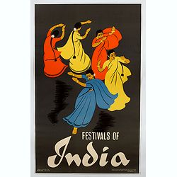
Festivals of India.
A large eye-catching poster of five women, dancing against a black background, dressed in stunning sari's of red, yellow and blue, produced in India by the Government, wi...
- $750 / ≈ €655
Date: Calcutta, 1959
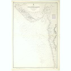
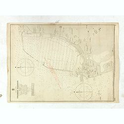
India west coast Gulf of Cutch to Vijaydurg . . .
Chart of India's west coast map surveyed by the hydrographer Captain JF Parry. A highly corrected version of Admiralty chart 2736 originally published 1st July 1915. Date...
- $200 / ≈ €175
Date: London, 1915-1980
