Browse Listings in Asia > Arabian Peninsular

90 listings found. Showing results 81 to 90
Die Asiatische Türkei. Die Kaukasusländer und West Persien.

Detailed map of Ottoman Asia or the Asian Turkey. Below the title a colored key to Turkish, Iran, Kurd, Caucasus and Russian possessions.Map prepared by H. Kiepert.

$75 / ≈ €64
Maker: WEIMAR GEOGRAPHSCHER INSTITUT
Date: Weimar, 1836-1838


Carte de L'Entrée de la Mer Rouge. Dressée par M.Daussy. . .

Very large and detailed chart depicting the entrance of the Red Sea, including the coastline of Yemen with inset "Carte du détroit de Bab!el-Mandeb. . ." and &...

$750 / ≈ €639
Maker: DÉPÔT GÉNÉRAL DE LA MARINE.
Date: Paris, ca. 1840


Egypte, Palestine, Syrie et Phoenicie.

Detailed map of Egypt, Palestine, Syria and Phoenicia, prepared by Charles V. Monin (fl.1830-1880) a French cartographer of Caen and Paris. Published in Atlas Universel d...

$25 / ≈ €21
Maker: MONIN, C.V.
Date: Paris, 1845


A Map of Arabia and Syria Laid Down Chiefly From Original Surveys Under the Superintendence of Lieut. Colonel Chesney, R.A.F.R.S. and drawn by W. H. Plate. L.L. D

This is one of the most significant and detailed maps of Arabia and the Persian Gulf. It is drawn by Plate using various sources. As stated below the cartouche the source...

$5000 / ≈ €4262
Maker: PLATE, William Henry F.
Date: London, 1849


Arabia.

A highly decorative and detailed map of Arabia, drawn and engraved by J.Rapkin and the Illustrations by H. Warren after J. Rogers.Taken from "The illustrated atlas a...

$275 / ≈ €234
Maker: TALLIS, J.
Date: London / New York: John Tallis & co, c.1851


Europish Turkije, Griekenland Jonische Eilander.

Uncommon map of Greece, Lithography by J.H. van Weijer, published in Atlas der geheele Aarde in 24 kaarten. With colored key to processions.

$10 / ≈ €9
Maker: SCHOLTENS, A.L.
Date: Groningen, ca. 1860


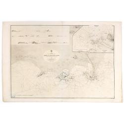
Arabia. Gulf of Aden - North Coast. Aden and Adjacent Bays..

Large chart focused east of Aden, in Yemen. With inset plan of Aden Anchorage in the upper right corner and a set of coastal profiles in the upper left corner.With latitu...

$900 / ≈ €767
Maker: HYDROGRAPHIC OFFICE
Date: London (1836) corrected to 1868


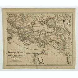
Karte des Türkischen Reiches in Europa und Asien . . .

Map of Turkish Empire.

$35 / ≈ €30
Maker: GRUSON, I.D.
Date: Breslau, 1878


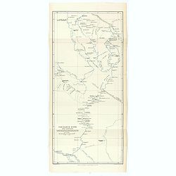
The Karun River and branches.

Karun River and branches map compiled from the charts of Colonel Chesney, Lieut. Selby and Captain Clements.The Karun continues toward the Persian Gulf, forking into two ...

$25 / ≈ €21
Maker: ROYAL GEOGRAPHICAL SOCIETY
Date: London, 1890


L'illustration, journal officiel hebdomadaire.

L'Illustration, the first French illustrated newspaper from 1843, became the first magazine in the world in 1906 and is distributed in more than 150 countries.The mythica...

$175 / ≈ €149
Maker: BASCHET, R.
Date: Paris, 1908