Browse Listings
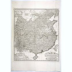
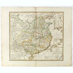
Carte Generale de la Chine Dressée sur les Cartes Particulieres Que l' Empereur Chang-Hi a fait lever sur les lieux..
Large map showing the traditional limits of China, including Hainan and Formosa in the South, and Quantong and parts of the Gobi Desert in the North.As the title notes, t...
Place & Date: Paris, Ph.-D. Pierres, Clousier [- Moutard], 1785
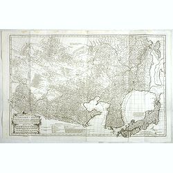
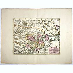
Carte Generale De La Tartarie Chinoise Dressee sur les Cartes Particulieres Faits Sur Les Lieux Par Les R.R. P.P. Jesuites . . . .MDCCXXXII
Very detailed map of Northern China, Japan and Korea. Jean Baptiste Bourguignon d' Anville (1697-1782), French cartographer. d'Anville used maps prepared by Jesuit missi...
Place & Date: Paris, Ph.-D. Pierres, Clousier [- Moutard], 1785
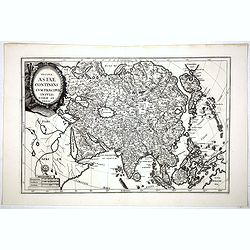
Totius Asiae continens cum praecipuis insulis eidem annexis
On this map Hokkaido is connected with Honshu and even bigger depicted than Honshu. In lower left cartouche a scale and a monstrance with the sign of the Society of Jesus...
Place & Date: Munich, 1710
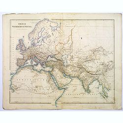
Orbis Veteribus Notus.
A detailed steel engraved map of the ancient world, stretching from Europe eastwards to the Black Sea and beyond, southwards through northern Africa, Arabia, India, and S...
Place & Date: London, 1839
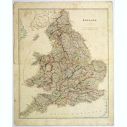
England.
A large and detailed steel engraved map of England, with each county divided by a different color. Many place names and physical features shown - it shows how densely pop...
Place & Date: London, 1839
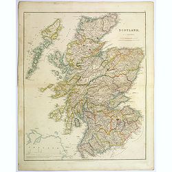
Scotland.
An attractive steel engraved map of Scotland, with each county divided by a different color. Many place names and physical features shown.The Arrowsmith family members we...
Place & Date: London, 1839
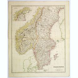
Sweden & Norway.
An attractive steel engraved map of Sweden & Norway. An inset map which is the continuation from Tornea to North Cape. Many place names and physical features shown.Th...
Place & Date: London, 1839
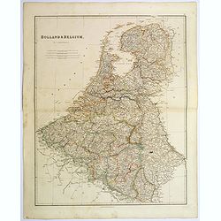
Holland & Belgium.
An attractive steel engraved map of Holland and Belgium. Map flanked by France and Prussia. Duchy of Luxembourg included. Many place names and physical features shown. 4 ...
Place & Date: London, 1839
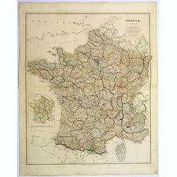
France.
A lovely, large steel engraved map of France, with an inset sketch of France divided into provinces, plus small inset map of the French Mediterranean island of Corsica . ...
Place & Date: London, 1839
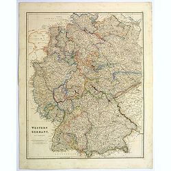
Western Germany.
A lovely, large steel engraved map of Western Germany. Some of the states engraved are: Holstein, Hannover, Mecklenburg, Saxony, Bavaria, Württemberg and Nassau. An extr...
Place & Date: London, 1839
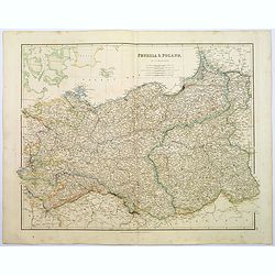
Prussia & Poland.
A glorious, large steel engraved map of Prussia and Poland. Some of the states covered are: Saxony, Pomerania, Posen, Brandenburg, Western & Eastern Prussia and the K...
Place & Date: London, 1839
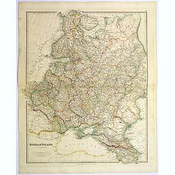
Russia & Poland.
A glorious, large steel engraved map of Russia and Poland. Covering Poland and Finland in the west, as far south as to the very edges of Persia, the Black sea, and to the...
Place & Date: London, 1839
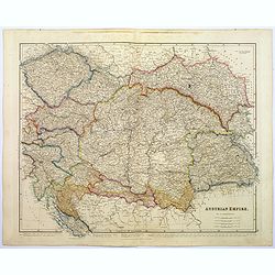
Austrian Empire.
A, large steel engraved map of the mighty Austrian Empire, covering Austria, Dalmatia, Styria, Slavonia, Hungary, Transylvania, Moravia and Bohemia. An enormous amount of...
Place & Date: London, 1839
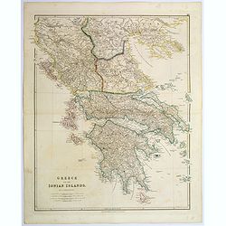
Greece and the Ionian Islands.
A large steel engraved map concentrating on Greece and the Ionian islands. Featured are Albania, Corfu, Macedonia, Central Greece and Morea., along with many small island...
Place & Date: London, 1839
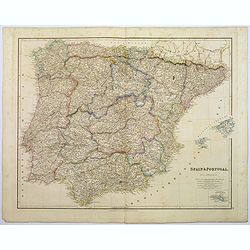
Spain & Portugal.
A large steel engraved map of European neighbours of Spain and Portugal. Including Balearic Islands, with a further inset map of Minorca. Numerous place names and physica...
Place & Date: London, 1839
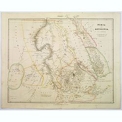
Nubia & Abyssinia.
A lovely looking steel engraved map of the portion of Africa that lies to the west of the Red sea. Mostly great deserts and the territories of nomadic African tribes are ...
Place & Date: London, 1839
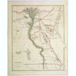
Egypt.
Quite a striking, large steel engraved map of Egypt. Following the course of the River Nile from Lower Egypt southwards to Upper Egypt, then crossing the border with Nubi...
Place & Date: London, 1839
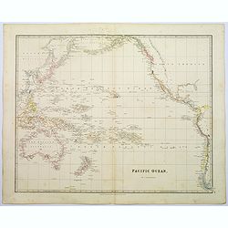
Pacific Ocean.
A wonderfully laid out map of the region, displaying the many island groups that make up this fascinating part of the world. The region is separated into parts, the South...
Place & Date: London, 1839
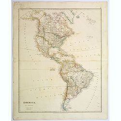
America.
A beautiful, large scale map of the Americas. Alaska is named as 'Russian America', Texas is still a part of Mexico, yet to become a republic (1836), before finally becom...
Place & Date: London, 1839

Upper Canada &c.
A beautiful, large scale map of Upper Canada, and portions of the American states of New York, Ohio, and Pennsylvania. The province of 'Upper' Canada was created by the B...
Place & Date: London, 1839
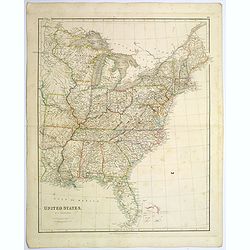
United States.
A lovely large map of the Untied States, as it was at the time of publication. Each state shown in a different outline color. Nothing is shown west of Louisiana, Arkansas...
Place & Date: London, 1839
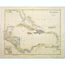
West Indies.
A fine, detailed steel engraved map comprising Florida, Bahamas, Cuba, Haiti, Jamaica, the Windward, and the Leeward Islands, the northern Columbian coastline, Panama, Gu...
Place & Date: London, 1839
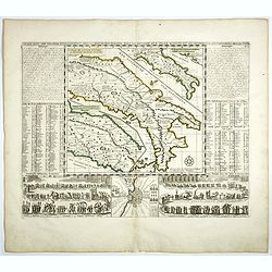
L'Italie dans son Premier Etablissement sous la Republique Romaine. . .
Map of Italy when first established under the Roman Republic after the division by Ayuguste Caesar, its various Papal governments: ancient Rome and its surround dings, a ...
Place & Date: Amsterdam, 1728
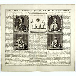
Habillemens Des Arabes & Des Juifs qui sont au Caire avec une partie de leurs divertissements & quelques restes de L'Ancien Idolatrie des peuples D'Egipte.
Decorative set of images the costumes of the Arab and Jewish inhabitants of Cairo, with French text, from Chatelain's monumental 7 volume Atlas Historique. Henri Abraham ...
Place & Date: Amsterdam, 1728
Nouvelle Carte de L'Empire De La Chine et les Pais circonvoisins - Nieuwe Kaart van t Keizerryk China en de aangrensende Landen.
Finely engraved map of China and Korea, with titles in both French and Dutch.The map extends west to the Gobi Desert and Tibet and shows Macao and Canton, among other cit...
Place & Date: Amsterdam, 1750

Nieuwe Kaart van de Grootbrittannische Volkplantingen in Noord America waar in Tevens de Fransche Bezittingen en de Landen tuschen die Beide Volken. . .
A map of the east-coast of America from New Foundland till Florida, divided in French and British properties. Reduced size Dutch edition of Mitchell's map of North Americ...
Place & Date: Amsterdam, 1769
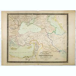
Carte physique et politique de la Turquie d'Europe et d'Asie contenant la Syrie, une partie de l'Egypte . . .
A detailed map including Turkey, Greece, Black Sea, Holy Land, Georgie, Iran, Iraq, Armenia.
Place & Date: Brussels, 1840

Carte des Indes, de la Chine & des Isles de Sumatra, Java &c..
This fine and quite detailed general map extends from northern Japan to Timor and from India to New Guinea.Here, the Terre de Yeco in northern Japan is still joined to th...
Place & Date: Amsterdam, 1720
Selling price: $450
Sold in 2018
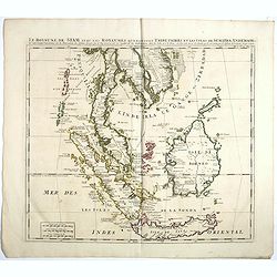
Le Royaume de Siam avec Les Royaumes Qui Luy sont Tributaries & c.
Influential map of Southeast Asia, including modern day Thailand, southern Vietnam, Cambodia, Malaysia, Singapore, Borneo, Sumatra and Java. Chatelain incorporated inform...
Place & Date: Amsterdam, c.1720
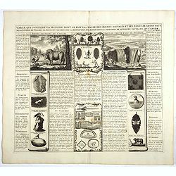
Carte qui contient la manière.. Niagara..
A series of 12 engravings together with descriptive text, derived from the works of Lahontan and Hennepin, illustrating the methods of the Indians hunting buffalo and sim...
Place & Date: The Hague 1720
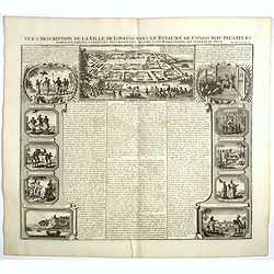
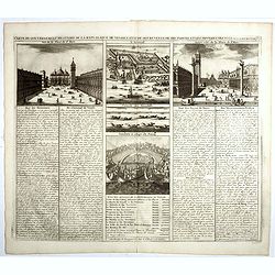
Vue et description de la Ville de Lovango dans le Royaume du Congo. . .
On top a large view of the fabled city of Lovango, text surrounded by ten vignettes of the people and ceremonies of the Kingdom of Congo.Zacharie Chatelain (d.1723) was t...
Place & Date: Amsterdam, 1720
Carte du gouvernement militaire de la République de Venise . . .
Very decorative folio sheet with five engraved views in Venice: "Vue de la Palace de St. Marc" (Piazza San Marco), a birds-eye map of "L'Arcenal", &qu...
Place & Date: Amsterdam, 1720
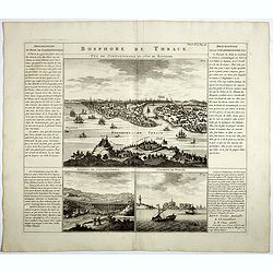
Bosphore de Thrace.
This handsome folio sheet present three views of the strategically important Bosporus. At top is a large decorative bird's-eye view of Istanbul as viewed from across the ...
Place & Date: Amsterdam, 1720
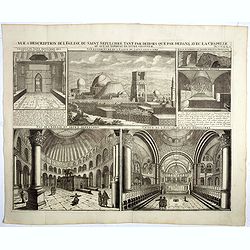
Vue & description de l'Eglise du Saint Sepulchre tant par dehors que dedans . . .
Shows various interiors and exterior views of the Church of the Holy Sepulcher in Jerusalem. From Chatelain's monumental 7 volume "Atlas Historique".Henri Abrah...
Place & Date: Amsterdam, 1720
![[Title page] France divisée en 83 departements. [with title in manuscript].](/uploads/cache/39099-250x250.jpg)
[Title page] France divisée en 83 departements. [with title in manuscript].
Title page with in panel manuscript title in brown ink "France divisée en 83 departements. . .". On verso a manuscript compass rose. Title page engraved by P. ...
Place & Date: Paris, ca. 1790
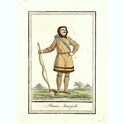
Homme Samojede.
Originally hand-colored mezzotint costume plate of a man from Samojede engraved by Félix Mixelle and Lachaussée Jeune after Jacques Grasset de Saint-Sauveur.As an etche...
Place & Date: Paris,1801-1806
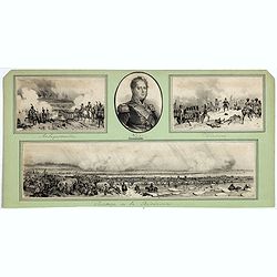
Passage de la Berezinas.
Set of four views of The Battle of Berezina (or Beresina) which took place from 26 to 29 November 1812, between the French army of Napoleon, retreating after his invasion...
Place & Date: ca. 1812
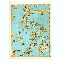
Philippines Islands.
Pictorial map of Philippines Islands, from the famous illustrator, Ruth Taylor White and published in "Our USA: A Gay Geography".Ruth Taylor White was among the...
Place & Date: Boston, Little, Brown and Company, 1935
Selling price: $250
Sold in 2018
![[The manner of making their boats.]](/uploads/cache/40467-250x250.jpg)
[The manner of making their boats.]
The manner of making boats in Virginia is wonderful to behold. They were able to do so without using any iron tool at all. First they chose a tall tree, wide enough for a...
Place & Date: Frankfurt, M.Merian, 1633
![[Ralegh arrives at Orocotona.]](/uploads/cache/40468-250x250.jpg)
[Ralegh arrives at Orocotona.]
On reaching the rapids of the Caroní, further up the Orinoco, Ralegh’s expedition was unable to proceed further by river, so they continued overland, eventually arrivi...
Place & Date: Frankfurt, M.Merian, 1633
![[ View of Ragusi]](/uploads/cache/45206-250x250.jpg)
[ View of Ragusi]
Very rare view of Ragusa published in the first edition of "Viaggio da Venetia, a Costantinopoli. Per Mare, e per Terra, & infieme quello di Terra Santa. Da Gios...
Place & Date: Venice, Giacomo Franco, 1598

Mappa geographica Provinciæ Nova Eboraci ab Anglis New-York . . .
Lower part of the two sheets map of Homann Heirs' edition of Sauthier's celebrated map of New York and New Jersey, made during the Revolutionary War. Appears in Homann's ...
Place & Date: Nuremburg, 1778

Spectacle Tennessee Williams composé de quatre pièces en 1 acte.
Theater poster for Tennessee Williams plays at the Theatre de l'Alliance Française in 1960. Poster printed in black and purple with design by K.Fernau. Playwright Tennes...
Place & Date: Paris, Lescaret, 1960
![[Lot of 7 Flower prints] Talauma mutabilis. flower Talauma mutabilis from 'FLORA MALESIANA' Arckenhausen del. / Hutz Lith.](/uploads/cache/IMG_0779-250x250.jpg)
[Lot of 7 Flower prints] Talauma mutabilis. flower Talauma mutabilis from 'FLORA MALESIANA' Arckenhausen del. / Hutz Lith.
The flower Talauma mutabilis from 'FLORA MALESIANA'. Talauma mutabilis by Karl Ludwig von Blume (9 June 1796, Braunschweig – 3 February 1862, Leiden) was a German-Dutch...
Place & Date: Germany, 1829
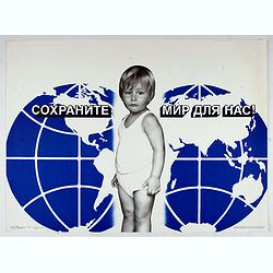
Save (the) world for us.
Uncommon Soviet propaganda poster. Text translates to : Save (the) world for us.Read more about the Soviet propaganda poster. [+]
Place & Date: Moscow, 1989
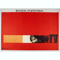
Ministry of health warned . . .
Uncommon Soviet propaganda poster against tobacco consumption.Read more about the Soviet propaganda poster. [+]
Place & Date: Moscow, 1988
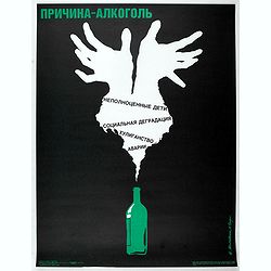
Cause alcohol. Defected children, social degradation, hooliganism, accidents.
Uncommon Soviet propaganda poster against alcoholism. A flame in the shape of North America is sorting a bottle.Read more about the Soviet propaganda poster. [+]
Place & Date: Moscow, 1990
![[Stop race of nuclear weapons.]](/uploads/cache/47059-250x250.jpg)
[Stop race of nuclear weapons.]
Uncommon Soviet propaganda poster.Read more about the Soviet propaganda poster. [+]
Place & Date: Moscow, 1986

Réseau aérien mondial.
"Sur les ailes d'Air France, découvrez le monde à votre tour" advertising planisphere poster from AIR France, the French airline company. The poster has alway...
Place & Date: Imprimerie Perceval Paris, ca. 1940-1950
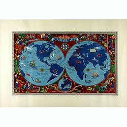
AIR France - Sur les ailes d'Air France découvrez le monde à votre tour.
Promotional poster of a double hemisphere world map designed by Lucien Boucher for AIR France. The map depicts the entire world in rich blues and burgundies with gold hig...
Place & Date: Perceval, Paris, 1952

Bal du Moulin Rouge Paris - Femmes Femmes Femmes..
Design by René Gruau for Moulin Rouge. René Gruau (1909-2004) was a Franco-Italian artist. He enjoyed real success after World War II working as a fashion illustrator f...
Place & Date: Paris, G. Cravenne, ca. 1980
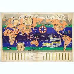
Le Tour du Monde en 120 Images Grand Concours du Chocolat Menier.
This highly unusual and rather novel pictorial map of the world was created by J.B. Jannot and published by Agence Française de Propagande as a promotional item for Meni...
Place & Date: Paris, 1956
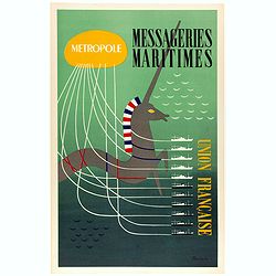
Metropole, Messageries Maritimes Union Française.
Original lithographed poster created by the artist Poulain for "Les Messageries Maritimes", showing several boats and a unicorn. Les Messageries Maritimes Compa...
Place & Date: Paris, ca. 1950

Chemin de fer de l'est - Luxeuil les Bains vers 1920.
Vintage Railway Travel Poster - Luxeuil les Bains, for the department Haute-Saône. Printed by Hachard Paris
Place & Date: Paris, ca. 1920
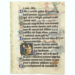
Illuminated leaf from a liturgical Psalter.
Very fine illuminated leaf from a liturgical Psalter in Latin with the reading from the Vulgate Bible. Lines in a slightly irregular Gothic hand, black ink, plummet rulin...
Place & Date: England, c. 1280
![Veduta di Istambul. [Gouache]](/uploads/cache/45368-250x250.jpg)
Veduta di Istambul. [Gouache]
Very decorative view depicting Istanbul, in the style of Neapolitan gouaches. Features different Mosques and the shores of the Bosporus. Many ships, small and large, are ...
Place & Date: Italy ?, ca. 1870
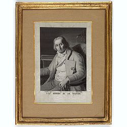
![[Portrait] - Me De Cet Corona se X+I. - Contantia et Fortudine](/uploads/cache/43510-250x250.jpg)
[Portrait] - Me De Cet Corona se X+I. - Contantia et Fortudine
Portrait of German Emperor Charles VI with his motto "Contantia et Fortudine". Holy Roman Emperor, 1711-1740, and King of Hungary as Charles III (1712-1740). Wi...
Place & Date: Germany, 1740
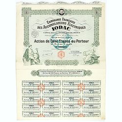
Shares of 100 francs. # 065320
This historic document has an ornate border around it with vignettes Mercury (goddess of trade) and woman holding a hammer and rested before an anvil. The logo of Iodac i...
Place & Date: Paris, 1933
![Bagdat le plan de Bagdat. [Manuscript plan of Bagdad]](/uploads/cache/45364-250x250.jpg)
Bagdat le plan de Bagdat. [Manuscript plan of Bagdad]
Manuscript plan of Baghdad, being a close copy of 'Les Six Voyages de Jean-Baptiste Tavernier en Turquie, en Perse et aux Indes' (1676). With a lettered key 1-16 to impor...
Place & Date: France, ca. 1700
(Portrait of Joseph-Marie Jacquard).
A rare woven silk portrait of Joseph-Marie Jacquard after Bonnefonds, completed on the Jacquard punched-card loom. Woven by Carquillat in the silk factory of Didier Petit...
Place & Date: France, ca. 1840
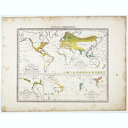
Distribuzione geografica delle Pianta coltivate . . .
Uncommon world map in Mercator projection representing food resources on 3 inset maps, prepared by Francesco Costantino Marmocchi. Above the map "Geografia Commercia...
Place & Date: Genova, Paolo Rivara fu Giacomo, 1858
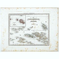
La Polinesia Francese.
Uncommon map of French Polynesia prepared by Francesco Costantino Marmocchi. Above the map "Geografia Commerciale". From "Il Globo Atlante di carte Geograf...
Place & Date: Genova, Paolo Rivara fu Giacomo, 1858
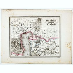
Il Turkestan il Mar d'Aral ed il Mar Caspio.
Uncommon map of Turkestan with the Northern part of the Caspian Sea, prepared by Francesco Costantino Marmocchi. Above the map "Geografia Commerciale". From &qu...
Place & Date: Genova, Paolo Rivara fu Giacomo, 1858
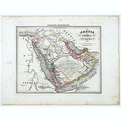
L'Arabia il Golfo Persico ed il Mar Rosco.
Uncommon map of Arabia prepared by Francesco Costantino Marmocchi. Above the map "Geografia Commerciale". From "Il Globo Atlante di carte Geografiche compi...
Place & Date: Genova, Paolo Rivara fu Giacomo, 1858
Selling price: $55
Sold in 2020
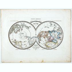
Mappamondo Carta d'Insieme.
Uncommon double hemisphere pole projection prepared by Francesco Costantino Marmocchi. Above the map "Geografia Commerciale". With a color code underneath the m...
Place & Date: Genova, Paolo Rivara fu Giacomo, 1858
![[Title page ] Il Globo Atalante di carte geografiche compilate da F.C. Marmocchi per servire di corredo al suo Corso di geografia commerciale.]](/uploads/cache/45291-250x250.jpg)
[Title page ] Il Globo Atalante di carte geografiche compilate da F.C. Marmocchi per servire di corredo al suo Corso di geografia commerciale.]
Title page prepared for Francesco Costantino Marmocchi's Atlas "Il Globo Atlante di carte Geografiche compilate da F.C. Marmocchi per servire di corredo al suu corso...
Place & Date: Genova, Paolo Rivara fu Giacomo, 1858
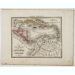
Le Indie Ocidentali ( Antille maggiori e minori, ecc) L'America Centrale . . .
Uncommon map of Central America and the Antilles prepared by Francesco Costantino Marmocchi. Above the map "Geografia Commerciale". From "Il Globo Atlante ...
Place & Date: Genova, Paolo Rivara fu Giacomo, 1858
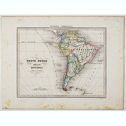
Nuovo Mondo parte Meridionale.
Uncommon map of South America prepared by Francesco Costantino Marmocchi. Above the map "Geografia Commerciale". From "Il Globo Atlante di carte Geografich...
Place & Date: Genova, Paolo Rivara fu Giacomo, 1858
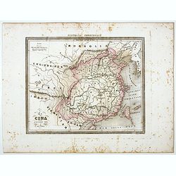
La Cina propriamente detta e sue isole.
Uncommon map of China prepared by Francesco Costantino Marmocchi. Above the map "Geografia Commerciale". From "Il Globo Atlante di carte Geografiche compil...
Place & Date: Genova, Paolo Rivara fu Giacomo, 1858
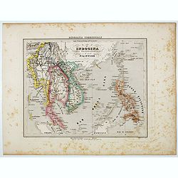
L'Indocina India Transgangetica e le Isole Filippine.
Uncommon map of part of Indo China and the Philippines prepared by Francesco Costantino Marmocchi. Above the map "Geografia Commerciale". From "Il Globo At...
Place & Date: Genova, Paolo Rivara fu Giacomo, 1858
Charte von China nach Murdochischer Projection entworfen. ... Berichtiget, und gezeichnet von H.F.A. Stieler. . .
Uncommon map of China prepared by H.F.A.Stieler, with parts of Taiwan, Tibet, Mongolia and the Korean peninsula, with a great many place names, a key to (and brief explan...
Place & Date: Augsburg, 1820
![Sopoto - Margaritino. [Sopot and Margarita in Albania]](/uploads/cache/45218-250x250.jpg)
Sopoto - Margaritino. [Sopot and Margarita in Albania]
Very rare view of Sopot and Margarita in Albania published in the first edition of "Viaggio da Venetia, a Costantinopoli. Per Mare, e per Terra, & infieme quello...
Place & Date: Venice, Giacomo Franco, 1598
![Fortezza Di Sopoto [Fortress of Sopot in Abania]](/uploads/cache/45216-250x250.jpg)
Fortezza Di Sopoto [Fortress of Sopot in Abania]
Very rare view of the Fortress of Sopot in Albania published in the first edition of "Viaggio da Venetia, a Costantinopoli. Per Mare, e per Terra, & infieme quel...
Place & Date: Venice, Giacomo Franco, 1598
![Valona [ View of Valona]](/uploads/cache/45215-250x250.jpg)
Valona [ View of Valona]
Very rare view of Vlora in Albania published in the first edition of "Viaggio da Venetia, a Costantinopoli. Per Mare, e per Terra, & infieme quello di Terra Sant...
Place & Date: Venice, Giacomo Franco, 1598
![Antivari [View of Bar in Montenegro]](/uploads/cache/45214-250x250.jpg)
Antivari [View of Bar in Montenegro]
Very rare view of Bar in Montenegro published in the first edition of "Viaggio da Venetia, a Costantinopoli. Per Mare, e per Terra, & infieme quello di Terra San...
Place & Date: Venice, Giacomo Franco, 1598
![Scutari [View of Shkodër - Albania]](/uploads/cache/45213-250x250.jpg)
Scutari [View of Shkodër - Albania]
Very rare view of Shkodër or Shkodra, historically known as Scutari or Scodra, is a city in the Republic of Albania. It is the capital of the surrounding county of Shkod...
Place & Date: Venice, Giacomo Franco, 1598
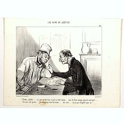
Les Gens de Justice. - Plaidez, plaidez . . . ça sera un bon tour à jouer à votre voisin. . . (pl 29)
Second state (of 2), with letters. From "Les Gens de Justice". Text below image : - Plaidez, plaidez . . . ça sera un bon tour à jouer à votre voisin . . . v...
Place & Date: Paris, 1845-1848

Les Gens de Justice. - Laissez dire un peu de mal de vous ... Laissez dire . . . (pl 32)
Second state, with letters. From "Les Gens de Justice". Text below image : - Laissez dire un peu de mal de vous … Laissez dire . . . (Don't you worry... just ...
Place & Date: Paris, 1845-1848

Les Gens de Justice. - L'avocat qui se trouve mal - dernière ressource quand la cause est bien malade. (pl 30)
Third state (of 3), with letters, "l'avocat" (with small a). From "Les Gens de Justice". Text below image : - L'avocat qui se trouve mal - dernière r...
Place & Date: Paris, 1845-1848

Les Gens de Justice. - Une Péroraison à la Démosthène (pl 33)
Second state (of 2), with text. From "Les Gens de Justice". Text below image : - Une Péroraison à la Démosthène . Around the mid-1840s Daumier started publi...
Place & Date: Paris, 1845-1848