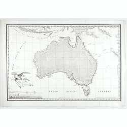
Browse Listings in Australia & Oceania
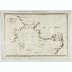
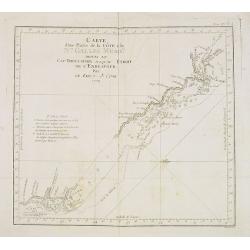
Carte de l'Entrée de Norton, et du Detroit de Bhering ou Von vou le Cap le plus oriental de l'Asie, et la Pointe la plus occidentale de l'Amerique.
Early detailed map of the passage between Asia and the NW Coast of America, including nice topographical details and the day by day tracks of Cook through the region in 1...
- $300 / ≈ €281
Place & Date: Paris, 1785
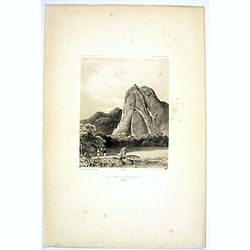
Montagne de la Manchiri.
Lithograph of the Montagne de la Manchiri in Papua New Guinea. It shows Breton, the artist on Dumont D'urville's voyage setting up a camera obscura in the foreground. Pla...
Place & Date: Paris, 1842
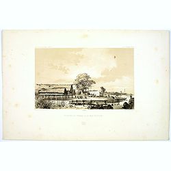
Pecheurs de Tripang a la Baie Raffles.
Fine lithograph of Javanese fishermen in the Bay of Raffles. Located at the eastern end of the Cobourg Peninsula, Raffles Bay was the site of the second abortive attempt ...
Place & Date: Paris, 1842
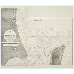
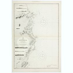
Australia, E. coast - Queensland Moreton Bay
Large chart representing East coast of Australia with Moreton Bay in Queensland.After a survey by Comr. J.Jeffery, etc. in 1865. New edition at the Admiralty 1870. With ...
Place & Date: London, 1882-1945
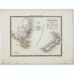
La Nuova Galles del Sud (Australia sud-est) La Diemenia e La Nuova Zelanda (Polinesia).
Uncommon map of East Coast of Australia and New Zealand prepared by Francesco Costantino Marmocchi. Above the map "Geografia Commerciale". From "Il Globo ...
Place & Date: Genova, Paolo Rivara fu Giacomo, 1858
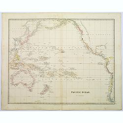
Pacific Ocean.
A wonderfully laid out map of the region, displaying the many island groups that make up this fascinating part of the world. The region is separated into parts, the South...
Place & Date: London, 1839
![[The description of Horn's Island].](/uploads/cache/41103-250x250.jpg)
[The description of Horn's Island].
This was a charming and beautiful island, full of coconuts, upas-root and wild pigs, which the natives either offered or sold to the Dutch. The natives seemed very wild a...
Place & Date: Frankfurt, M.Merian, 1633
![[The natives eat, drink and dance for their king].](/uploads/cache/41104-250x250.jpg)
[The natives eat, drink and dance for their king].
Food was carried on the natives’ heads as they humbly crept forward on their knees to greet the Dutch. The drink, called cava, was made from a certain plant, which they...
Place & Date: Frankfurt, M.Merian, 1633
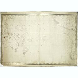
Carte générale de l'océan pacifique. . .
depicting the Pacific Ocean, with nice detail of Hawaii. With a complete outline for Australia and Tasmania. Shows the south east Asian region and South America.Mapping ...
Place & Date: Paris, 1833
![[The Dutch are received at another island in Samoa].](/uploads/cache/41105-250x250.jpg)
[The Dutch are received at another island in Samoa].
On visiting another island [in Samoa] the Dutch were made heartily welcome by the king and all the inhabitants. A king of another neighbouring island also called to meet ...
Place & Date: Frankfurt, M.Merian, 1633
![[The adventures of the Dutch at 'Bottomless' island in Samoa].](/uploads/cache/41106-250x250.jpg)
[The adventures of the Dutch at 'Bottomless' island in Samoa].
The Dutch arrived at an island [in Samoa] fringed with wild vines on which there were native men with long hair and native women with short hair. Because the water surrou...
Place & Date: Frankfurt, M.Merian, 1633
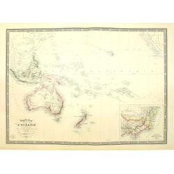
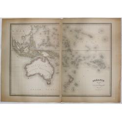
Nouvelle carte de l'Océanie dressée d'après les documents les plus récents par A. Vuillemin, géographe.
Very large, highly detailed and uncommon map of the Pacific with Australia and New Zealand, with inset map of "Partie de l'Australie (Nouvelle Galles du Sud) et Vict...
Place & Date: Paris, 1876
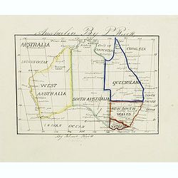
Australia by P.Rivett.
Manuscript map of Australia without Tasmania, prepared by Palmer Rivett, who was born around 1858 in Blundeston, Suffolk, England, where he spent most of his life. He was...
Place & Date: c. 1860-1870
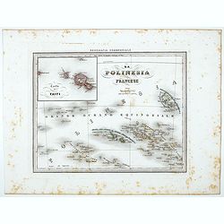
La Polinesia Francese.
Uncommon map of French Polynesia prepared by Francesco Costantino Marmocchi. Above the map "Geografia Commerciale". From "Il Globo Atlante di carte Geograf...
Place & Date: Genova, Paolo Rivara fu Giacomo, 1858
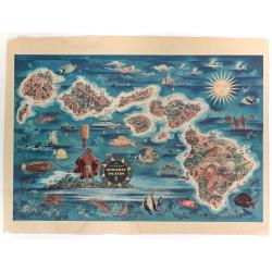
The Dole Map of the Hawaiian Islands.
A terrific, colorful poster of the Hawaiian Islands by Joseph Feher, commissioned for the Hawaiian Pineaple Co. The poster displays all eight of the major islands in the ...
- $250 / ≈ €234
Place & Date: USA, 1950
![Nouvelle-Hollande. Oui-Re-Kine. [plate XXI]](/uploads/cache/40110-250x250.jpg)
Nouvelle-Hollande. Oui-Re-Kine. [plate XXI]
A portrait of a female aboriginal residing in Sydney.After the original sketches by Lesueur, from Voyage de découvertes aux terres Australes by François Péron, 1824.Th...
- $100 / ≈ €94
Place & Date: Paris, 1824
![Nouvelle-Hollande: Nouvelle Galles du Sud. Navigation. [plate XXIII]](/uploads/cache/40112-250x250.jpg)
Nouvelle-Hollande: Nouvelle Galles du Sud. Navigation. [plate XXIII]
Aboriginal boats, used for hunting and water transportationAfter the original sketches by Lesueur, from Voyage de découvertes aux terres Australes by François Péron, 1...
- $100 / ≈ €94
Place & Date: Paris, 1824
![Phisique. [plate XL]](/uploads/cache/40124-250x250.jpg)
Phisique. [plate XL]
Some scientific instruments for measuring the sea temperature at some depth. From Voyage de découvertes aux terres Australes by François Péron, 1824.The French expedit...
- $40 / ≈ €37
Place & Date: Paris, 1824
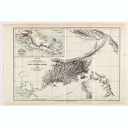
New Guinea. Map illustrating Sir. w. Macgregor's route to the Owen Stanley Range 1889.
Map illustrating Sir. w. Macgregor's route to the Owen Stanley Range 1889. With inset map of South-East New Guinea.Fine colored lithograph map lithographed by Turner &...
- $50 / ≈ €47
Place & Date: London, Edward Stanford, 1890
Polynesia or Islands in the Pacific Ocean.
Decorative and attractive map of the Islands in the Pacific Ocean. The map extent shows parts of California, Papua New Guinea, eastern Australia, and southern Japan.The m...
- $175 / ≈ €164
Place & Date: London ,1851

Paskaerte Zynde t'Oosterdeel Van Oost Indien, met alle de Eylanden daer ontrendt geleegen van C. Comorin tota aen Iapan.
An eye-catching chart of Pieter Goos' sea chart of Australia, Southeast Asia, China, Japan, Korea and India. The chart shows the regions from Cape Comorin (Southern India...
Place & Date: Amsterdam, 1669
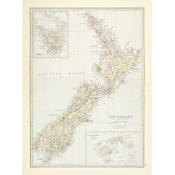
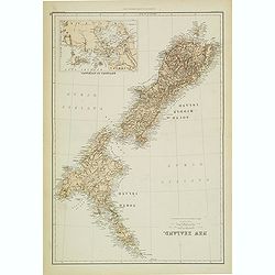
New Zealand.
Very detailed map of New Zealand, with inserts of Tasmania and Fiji Islands. The map was printed from lithographic stones taken from a hand-engraved steel plate. The cart...
- $150 / ≈ €140
Place & Date: Edinburg, ca 1881
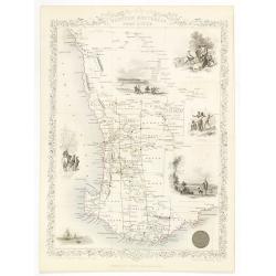
Western Australia. Swan River.
Decorative steel engraved map of part of Western Australia and Swan River, surrounded by illustrations of Perth, Aborigines and sheep shearing. With the seal of Western A...
- $300 / ≈ €281
Place & Date: London, ca. 1851
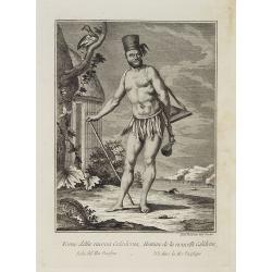
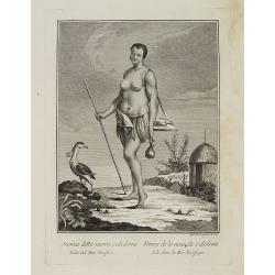
Uomo della nuova Caledonia Isola del Mar Pacifico. / Homme de la nouvelle Calédonie Isle dans la Mer Pacifique.
Full portrait of a native from New Caledonia. A rare engraving from "Raccolata di stampe ... di varie nazioni". From the original drawing by William Hodges, who...
- $300 / ≈ €281
Place & Date: Venice, Antonio Zatta, c.1790
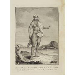
Donna della nuova Caledonia Isola del Mar Pacifico. / Femme de la nouvelle Calédonie Isle dans la Mer Pacifique.
Full portrait of a woman from New Caledonia. A rare engraving from "Raccolata di stampe ... di varie nazioni". From the original drawing by William Hodges, who ...
- $350 / ≈ €328
Place & Date: Venice, Antonio Zatta, c.1790
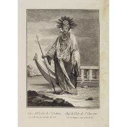
Capo dell' Isola di S.a Cristina una delle Marchesi nel Mar Pacifico del Sud. / Chef de l'Isle de Ste. Christine une des Marquises dans la Mer Pacifique du Sud.
Full portrait of the Chief of the Saint Christina Island. A rare engraving from "Raccolata di stampe ... di varie nazioni". From the original drawing by William...
- $350 / ≈ €328
Place & Date: Venice, Antonio Zatta, c.1790
Donna dell' Isola di S.a Cristina una delle Marchesi nel Mar del Sud. / Femme de l' Isle de S.e Christine une des Marquises dans la Mer du Sud.
Full portrait of a woman from the Saint Christina Island. A rare engraving from "Raccolata di stampe ... di varie nazioni". From the original drawing by William...
- $350 / ≈ €328
Place & Date: Venice, Antonio Zatta, c.1790
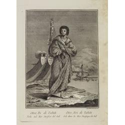
Otoo, Re di Tahiti Isola nel Mar Pacifico del Sud. / Otoo, Roi de Tahiti Isle dans la Mer Pacifique du Sud.
Full portrait of the Hawaiian King Otoo. A rare engraving from "Raccolata di stampe ... di varie nazioni". From the original drawing by William Hodges, who acco...
- $300 / ≈ €281
Place & Date: Venice, Antonio Zatta, c.1790
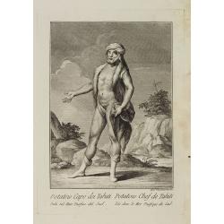
Potatow Capo dei Tahiti Isola nel Mare Pacifico del Sud. / Potatow Chef de Tahiti Isle dans la Mer Pacifique du Sud.
Full portrait of the Hawaiian chief Potatow. A rare engraving from "Raccolata di stampe ... di varie nazioni". From the original drawing by William Hodges, who ...
- $250 / ≈ €234
Place & Date: Venice, Antonio Zatta, c.1790
Capo della flotta degli Otahiti nel Mar Pacifico del Sud. / Chef de la flotte des Otahiti dans la Mer Pacifique du Sud.
Full portrait of captain of the Otahiti flotilla. A rare engraving from "Raccolata di stampe ... di varie nazioni". From the original drawing by William Hodges,...
- $450 / ≈ €421
Place & Date: Venice, Antonio Zatta, c.1790
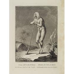
Uomo dell' Isola di Tanna, una delle nuove Ebridi nel Mar Pacifico. / Homme de l' Isle de Tanna, une des nouvelles Hébrides dans la Mer du Pacifique.
Full portrait of a man from the island of Tanna in the Pacific. A rare engraving from "Raccolata di stampe ... di varie nazioni". From the original drawing by W...
- $250 / ≈ €234
Place & Date: Venice, Antonio Zatta, c.1790
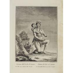
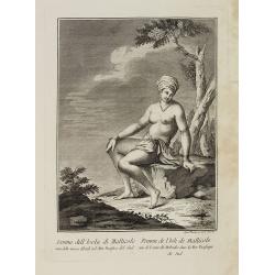
Donna dell' Isola di Tanna, una delle nuove Ebridi nel Mar Pacifico. / Femme de l' Isle de Tanna, une des nouvelles Hebrides dans la Mer Pacifique.
Full portrait of a woman, a native from the island of Mallico. A rare engraving from "Raccolata di stampe ... di varie nazioni". From the original drawing by Wi...
- $250 / ≈ €234
Place & Date: Venice, Antonio Zatta, c.1790
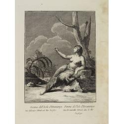
Donna dell' Isola di Mallicolo una delle nuove Ebridi nel Mar Pacifico del Sud. / Femme de l' Isle d'Erramanga une des nouvelles Hebrides dans la Mer Pacifique du Sud.
Full portrait of a woman, a native of the island of Mallico. A rare engraving from "Raccolata di stampe ... di varie nazioni". From the original drawing by Will...
- $250 / ≈ €234
Place & Date: Venice, Antonio Zatta, c.1790
Donna dell' Isola d' Erramanga una delle nuove Ebridi nel Mar Pacifico. / Femme de l'Isle d'Erramanga une des nouvelles Hebrides dans la Mer Pacifique.
Full portrait of a woman, native of the island of Erramanga in the Pacific. A rare engraving from "Raccolata di stampe ... di varie nazioni". From the original ...
- $250 / ≈ €234
Place & Date: Venice, Antonio Zatta, c.1790
![[Scene of a meeting. The Friendly Islands ].](/uploads/cache/26386-250x250.jpg)
[Scene of a meeting. The Friendly Islands ].
Aquatint depicting an indoor meeting in the Friendly Islands. Plate N°79. From Giulio Ferrario's work Le Costume Ancien et Moderne ou Histoire du gouvernement, de la mil...
- $75 / ≈ €70
Place & Date: Milan, 1827
![[Portraits. Friendly Islands ].](/uploads/cache/26385-250x250.jpg)
[Portraits. Friendly Islands ].
Aquatint depicting inhabitants of the Friendly Islands. Plate N°79. From Giulio Ferrario's work Le Costume Ancien et Moderne ou Histoire du gouvernement, de la milice, d...
- $50 / ≈ €47
Place & Date: Milan, 1827
![[The Friendly Islands ].](/uploads/cache/26384-250x250.jpg)
[The Friendly Islands ].
Aquatint depicting seashore scene of the Friendly Islands. These islands are also known as the Friendly Islands because of the friendly reception accorded to Captain Cook...
- $50 / ≈ €47
Place & Date: Milan, 1827
![[Queen Obera welcoming Captain Wallis. Tahiti ].](/uploads/cache/26381-250x250.jpg)
[Queen Obera welcoming Captain Wallis. Tahiti ].
Aquatint depicting Queen Obera welcoming Captain Wallis upon his arrival in Tahiti. Engraved by Gallina. Plate N° 82. From Giulio Ferrario's work Le Costume Ancien et Mo...
- $50 / ≈ €47
Place & Date: Milan, 1827
![[Tahitian tools ].](/uploads/cache/26378-250x250.jpg)
[Tahitian tools ].
Aquatint depicting a variety of Tahitian tools engraved by Rivelanti. Plate N° 85. From Giulio Ferrario's work Le Costume Ancien et Moderne ou Histoire du gouvernement, ...
- $50 / ≈ €47
Place & Date: Milan, 1827
Carte Generale de la Nouvelle Hollande.
Fine map of the continent of Australia prepared by Louis Freycinet during his voyage under Captain Thomas Baudin in 1800-1803. Freycinet's map of New Holland was the firs...
- $5000 / ≈ €4679
Place & Date: Paris, Imprimerie Royale, 1811
![Plan du Port du Roi-George [with] Plan de la Baie du Geographe.](/uploads/cache/46371-250x250.jpg)
Plan du Port du Roi-George [with] Plan de la Baie du Geographe.
Two maps on one sheet, King George Sound and Geographe Bay, now Busselton and Dunsborough area and the earliest chart of this area, from Voyage de découvertes aux terres...
- $500 / ≈ €468
Place & Date: Paris, 1807-1816
![Plan des Iles Jérôme [with] Plan des Iles Berthier [with] Plan du Comté de Cumberland.](/uploads/cache/46370-250x250.jpg)
Plan des Iles Jérôme [with] Plan des Iles Berthier [with] Plan du Comté de Cumberland.
Three maps on one sheet, Jérôme islands, Berthier islands and Cumberland county, from Voyage de découvertes aux terres Australes by François Péron, 1824. The French ...
- $100 / ≈ €94
Place & Date: Paris, 1807-1816
![Plan d'une partie de la Terre Napoléon [with] Plan des Iles Joséphine et de la Baie Murat.](/uploads/cache/46367-250x250.jpg)
Plan d'une partie de la Terre Napoléon [with] Plan des Iles Joséphine et de la Baie Murat.
Two maps showing Descartes Bay and Bridgewater Bay in Victoria and Murat Bay in South Australia showing French discoveries prepared by Louis Freycinet during his voyage u...
- $100 / ≈ €94
Place & Date: Paris, 1807-1816
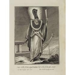
![Otago Capo dell'Isola d'Amsterdam nel Mare Pacifico del Sud [to left]. Otago Chef de l'Isle d'Amsterdam dans la Mer Pacifique du Sud. . .](/uploads/cache/26090-250x250.jpg)
Otago Capo dell'Isola d'Amsterdam nel Mare Pacifico del Sud [to left]. Otago Chef de l'Isle d'Amsterdam dans la Mer Pacifique du Sud. . .
Otago Capo dell'Isola d'Amsterdam nel Mare Pacifico del Sud [to left]. Otago Chef de l'Isle d'Amsterdam dans la Mer Pacifique du Sud [to right]. Li Vomini di questa Isola...
- $275 / ≈ €257
Place & Date: Venice, Antonio Zatta, c.1790
![Coffre Sculpté des Habitants de la nouvelle Zélande. [Tome III Pl. 13.]](/uploads/cache/26092-250x250.jpg)
Coffre Sculpté des Habitants de la nouvelle Zélande. [Tome III Pl. 13.]
A carved chest of New Zealand, as a specimen of the carving of the country. Engraving drawn after John Frederick Miller (1759-1796). John Frederick Miller was an English ...
- $25 / ≈ €23
Place & Date: Paris, 1773
![Hausse-col militaire des insulaires de la Mer du Sud. [Tome II Pl. 12.]](/uploads/cache/26095-250x250.jpg)
Hausse-col militaire des insulaires de la Mer du Sud. [Tome II Pl. 12.]
Maori warrior rise-collar. From the French edition of James Cook's first voyage entitled Relation des voyages entrepris par ordre de sa Majesté Britannique actuellement ...
- $25 / ≈ €23
Place & Date: Paris, 1773
![Instruments des insulaires de la Mer du Sud. [Tome II Pl. 15.]](/uploads/cache/26097-250x250.jpg)
Instruments des insulaires de la Mer du Sud. [Tome II Pl. 15.]
Divers tools. From the French edition of James Cook's first voyage entitled Relation des voyages entrepris par ordre de sa Majesté Britannique actuellement régnante pou...
- $15 / ≈ €14
Place & Date: Paris, 1773
![Emouchoir des Otahitiens avec ses manches. [Tome II Pl. 13.]](/uploads/cache/26098-250x250.jpg)
Emouchoir des Otahitiens avec ses manches. [Tome II Pl. 13.]
From the French edition of James Cook's first voyage entitled Relation des voyages entrepris par ordre de sa Majesté Britannique actuellement régnante pour faire des d�...
- $25 / ≈ €23
Place & Date: Paris, 1773
![Vue de l'Isle d'Otahiti et de plusieurs Pirogues. [Tome II Pl. 11.]](/uploads/cache/26102-250x250.jpg)
Vue de l'Isle d'Otahiti et de plusieurs Pirogues. [Tome II Pl. 11.]
View of the Island of Tahiti and dugouts. From the French edition of James Cook's first voyage entitled Relation des voyages entrepris par ordre de sa Majesté Britanniqu...
- $75 / ≈ €70
Place & Date: Paris, 1773
![Vue de l'Isle d'Ulietéa avec une double Pirogue et un hangar où les Insulaires retirent leurs bâtiments de mer. [Tome III Pl. 5.]](/uploads/cache/26106-250x250.jpg)
Vue de l'Isle d'Ulietéa avec une double Pirogue et un hangar où les Insulaires retirent leurs bâtiments de mer. [Tome III Pl. 5.]
A view on the Island of Ulietea, French Polynesia, of a dugout boat house and a beautifully engraved pirogue at sea. From the French edition of James Cook's first voyage ...
- $50 / ≈ €47
Place & Date: Paris, 1773
![Vue de l'Isle d'Huaheine avec La Maison de Dieu, et un petit Autel couvert d'offrandes. [Tome III Pl. 4.]](/uploads/cache/26108-250x250.jpg)
Vue de l'Isle d'Huaheine avec La Maison de Dieu, et un petit Autel couvert d'offrandes. [Tome III Pl. 4.]
A view of the Island of Huaheine, Tahiti, a beautiful tropical Owharra tree in the foreground and a depiction of the House of God with its offertory. From the French edit...
- $50 / ≈ €47
Place & Date: Paris, 1773
![Village fortifié bâti sur un Rocher troué de la Nouvelle Zélande. [Tome III Pl. 10.]](/uploads/cache/26110-250x250.jpg)
Village fortifié bâti sur un Rocher troué de la Nouvelle Zélande. [Tome III Pl. 10.]
A view of a village fortified on a hollow rock in New Zealand. Engraved by François Godefroi. From the French edition of James Cook's first voyage entitled Relation des ...
- $50 / ≈ €47
Place & Date: Paris, 1774
![Vue d'un Rocher troué de la Nouvelle Zélande. [Tome III Pl. 8.]](/uploads/cache/26112-250x250.jpg)
Vue d'un Rocher troué de la Nouvelle Zélande. [Tome III Pl. 8.]
A view of a New Zealand landscape and seascape through a hollow rock. Engraved by Demouchy. From the French edition of James Cook's first voyage entitled Relation des voy...
- $30 / ≈ €28
Place & Date: Paris, 1773
![Mortuary scene. Tahiti Islands ].](/uploads/cache/26380-250x250.jpg)
Mortuary scene. Tahiti Islands ].
This aquatint depicts a mortuary scene in front of a tapapow, a shed under which the dead bodies remains are exposed until they dry. Engraved by Roffi. Plate N° 83. From...
- $50 / ≈ €47
Place & Date: Milan, 1827
![[Tahitian warrior dugouts ].](/uploads/cache/26377-250x250.jpg)
[Tahitian warrior dugouts ].
Aquatint depicting a view of Tahitian warrior dugouts engraved by Fumagalli. Plate N° 86. From Giulio Ferrario's work Le Costume Ancien et Moderne ou Histoire du gouvern...
- $50 / ≈ €47
Place & Date: Milan, 1827
![[Women dancing in a Ulietea house ].](/uploads/cache/26376-250x250.jpg)
[Women dancing in a Ulietea house ].
Aquatint depicting women dancing in front of musicians and local villagers in a Ulietea house. Plate N° 87. From Giulio Ferrario's work Le Costume Ancien et Moderne ou H...
- $50 / ≈ €47
Place & Date: Milan, 1827
![[Easter Island inhabitants ].](/uploads/cache/26375-250x250.jpg)
[Easter Island inhabitants ].
Aquatint depicting 2 portraits of Easter Island inhabitants and 2 men rowing in a pirogue. Engraved by Carlo Bottigella. Plate N° 88. From Giulio Ferrario's work Le Cost...
- $80 / ≈ €75
Place & Date: Milan, 1827
![[Marquesas Islands headdresses and head ornaments ].](/uploads/cache/26374-250x250.jpg)
[Marquesas Islands headdresses and head ornaments ].
Aquatint depicting Marquesas Islanders in traditional headdresses and a variety of head ornaments engraved by Bonatti. Plate N° 90. From Giulio Ferrario's work Le Costum...
- $50 / ≈ €47
Place & Date: Milan, 1827
![[Pirogues in the bay of the voyage of the Resolution. The Marquesas Islands ].](/uploads/cache/26373-250x250.jpg)
[Pirogues in the bay of the voyage of the Resolution. The Marquesas Islands ].
Aquatint depicting men in pirogues in the Bay of the Resolution from the Marquesas Islands engraved by Biasioli. Plate N° 91. HMS Resolution was a sloop of the Royal Nav...
- $50 / ≈ €47
Place & Date: Milan, 1827
![[New Caledonians ].](/uploads/cache/26367-250x250.jpg)
[New Caledonians ].
Aquatint depicting New Caledonians engraved by Biasioli. Plate N° 71. From Giulio Ferrario's work Le Costume Ancien et Moderne ou Histoire du gouvernement, de la milice,...
- $50 / ≈ €47
Place & Date: Milan, 1827
![[The Admiralty Islands and New Britain inhabitants fishing. Papua New Guinea ].](/uploads/cache/26365-250x250.jpg)
[The Admiralty Islands and New Britain inhabitants fishing. Papua New Guinea ].
Aquatint depicting fishermen in dugouts engraved by A. Biasioli. Plate N° 14. From Giulio Ferrario's work Le Costume Ancien et Moderne ou Histoire du gouvernement, de la...
- $75 / ≈ €70
Place & Date: Milan, 1827
![[Papua New Guinea Inhabitants ].](/uploads/cache/26364-250x250.jpg)
[Papua New Guinea Inhabitants ].
Aquatint depicts three men in a pirogue engraved by Fumagalli. Plate N° 75. From Giulio Ferrario's work Le Costume Ancien et Moderne ou Histoire du gouvernement, de la m...
- $80 / ≈ €75
Place & Date: Milan, 1827
![Manière dont on expose les morts à Otahiti. [Tome II Pl. 16.]](/uploads/cache/26113-250x250.jpg)
Manière dont on expose les morts à Otahiti. [Tome II Pl. 16.]
A view of a Tahitian funeral home in a beautiful landscape. Engraved by Demouchy. From the French edition of James Cook's first voyage entitled Relation des voyages entre...
- $50 / ≈ €47
Place & Date: Paris, 1773
![Cession de l'Isle d'Ohahiti au Capitaine Wallis par la Reine Obéréa. [Tome II Pl. 2.]](/uploads/cache/26111-250x250.jpg)
Cession de l'Isle d'Ohahiti au Capitaine Wallis par la Reine Obéréa. [Tome II Pl. 2.]
The Queen Oberea's transfer ceremony on Tahiti to Captain Wallis.Engraved by François Godefroi. From the French edition of James Cook's first voyage entitled Relation de...
- $50 / ≈ €47
Place & Date: Paris, 1774
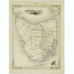
Van Diemen's Island or Tasmania.
Decorative steel engraved map of Tasmania. Taken from "The illustrated atlas and modern history of the world by John Tallis", published between 1849 and 1853. T...
- $225 / ≈ €211
Place & Date: London, 1851
New Zealand (with Environs of Auckland)
Striking map of New Zealand, with a large inset map of the environs of Auckland. Made by J. Bartholomew. NO. 66 in lower right corner.
- $200 / ≈ €187
Place & Date: Glasgow, London, 1882
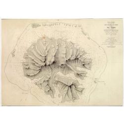
Océan Pacifique. Archipel de la Société. Iles Raiatea et Tahaa. 1ère Feuille. Ile Tahaa..
Large scale chart focused on the island Tahaa, in French Polynesia.Showing a few details of the village of Tahaa, banks, isles and soundings made in meters. Relief is sho...
- $200 / ≈ €187
Place & Date: Paris, 1885
Carte d'une Partie de la Côte, de la Nle Galles Meridle depuis le Cap Tribulation jusqu'au Detroit de l'Endeavour par le Lieut. J. Cook 1770. Tome IV. Pl. 3.
Map of a part of the New galles Meridle Coastline in Australia from the Cap Tribulation to the Endeavour Detroit. This map is taken from the first French edition of Jame...
- $300 / ≈ €281
Place & Date: Paris, 1774

Voyage de découvertes aux Terres Australes. Historique. Atlas Deuxième partie.
First edition of the second part of the atlas by Freycinet, part of his important book "Voyage de découvertes aux Terres Australes". Illustrated with two foldi...
- $7500 / ≈ €7018
Place & Date: Paris, Langlois, 1811
Océanie dressée par A.H. Dufour géographe.
Wall-sized map (87x117cm) in two sheets prepared by Adolphe Hippolyte Dufour, giving good detail to Australia and New Zealand, due to extensive discoveries of the French ...
- $1200 / ≈ €1123
Place & Date: Paris, 1854
![Terre de Diemen. Habitations. [plate XV].](/uploads/cache/46278-250x250.jpg)
Terre de Diemen. Habitations. [plate XV].
An aboriginal camp fire, near the ruins of an old wooden fence, and a dead tree, after the original sketches by Lesueur, from Voyage de découvertes aux terres Australes ...
- $200 / ≈ €187
Place & Date: Paris, 1824
![Nouvelle-Hollande: Nelle. Galles du sud - Navigation. [plate XXIII]](/uploads/cache/46345-250x250.jpg)
Nouvelle-Hollande: Nelle. Galles du sud - Navigation. [plate XXIII]
An aboriginal camp fire, with a pirogue and two men navigating , after the original sketches by Lesueur, from Voyage de découvertes aux terres Australes by François Pé...
- $300 / ≈ €281
Place & Date: Paris, 1824
Sheet V East coast of Australia. New South Wales Evans Head to Danger Pt. surveyed by Comr. Fredk. W. Sidney R.N. . . 1864-5. . .
Large chart representing East coast of Australia with New South Wales including Evans Head to Danger Pt. surveyed by Comr. Fredk. W. Sidney R.N. from 1864 - 1865. First p...
- $150 / ≈ €140
Place & Date: London, 1866-1943
![Plan de la partie sud des Iles Furneaux [with] Carte générale de la Partie Sud-Est de la Terre de Diémen . . .](/uploads/cache/46365-250x250.jpg)
Plan de la partie sud des Iles Furneaux [with] Carte générale de la Partie Sud-Est de la Terre de Diémen . . .
Two maps on one sheet, on top a map of the southern portion of Cape Barren Island, Clarke Island, and islets in the southern part of the Furneaux Group.With in lower part...
- $200 / ≈ €187
Place & Date: Paris, 1824
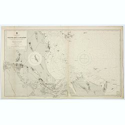
Australia - East coast Queensland Keppel Bay and Islands surveyed by staff Commr. J.Jeffery. . . 1864. . .
Large chart representing East coast of Australia with Queensland including Keppel Bay and Islands surveyed by Comr. J.Jeffery in 1864. First published at the Admiralty 3r...
- $150 / ≈ €140
Place & Date: London, 1866-1943
![Plan de la Baie Laplace [with] Esquisse du Port Western [with] Plan des Iles Forestier [with] Esquisse du Port Champagny.](/uploads/cache/46372-250x250.jpg)
Plan de la Baie Laplace [with] Esquisse du Port Western [with] Plan des Iles Forestier [with] Esquisse du Port Champagny.
Four maps on one sheet, Laplace Bay, Western Harbour, Forestier islands and Champagny Harbour, from Voyage de découvertes aux terres Australes by François Péron, 1824....
- $200 / ≈ €187
Place & Date: Paris, 1824
![Nouvelle-Hollande: Ile Bernier. - Kanguroo a Bandes [plate XXVII]](/uploads/cache/46349-250x250.jpg)
Nouvelle-Hollande: Ile Bernier. - Kanguroo a Bandes [plate XXVII]
Plate illustrating Kanguroo a Bandes by Lesueur, from Voyage de découvertes aux terres Australes by François Péron, 1824.The French expedition under Nicolas Baudin, wa...
- $300 / ≈ €281
Place & Date: Paris, 1824
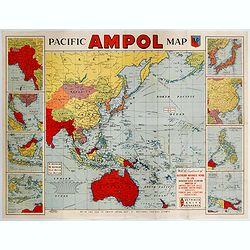
Pacific AMPOL Map
A large and very colorful World War II era map of the Pacific Ocean produced with the complements of the Australian Motorists Petrol Co. Ltd. The map itself shows the Pac...
- $1000 / ≈ €936
Place & Date: Australia, ca 1942
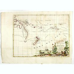
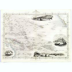
Nuova Guinea e Nuova Galles ed Isole Adjacenti
Map of the South Pacific, showing the sailing routes to the South Pacific by Carteret and Byron, but most importantly the discoveries made by Captain Cook, 1768-1771. The...
- $1750 / ≈ €1638
Place & Date: Venise, 1794-1796
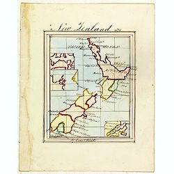
New Zealand 1870
Manuscript map of new Zealand, signed in lower border "By Ernst Pivett. Perhaps a school exercise map.
- $200 / ≈ €187
Place & Date: London, ca. 1870