Browse Listings in Europe

Woman of Brabant.
Very fine view of a woman wearing the traditional dress of Brabant.
- $150 / ≈ €140
Place & Date: London, 1817
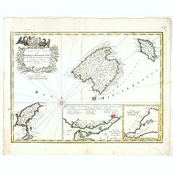
Carte des Isles de Maiorque Minorque et Yvice.
Uncommon map of Majorca, Minorca and Ibiza prepared by J.N. Bellin. With an inset plan of the harbor of Mahon "Plan du Port et de la Ville de Mahon", and a seco...
- $700 / ≈ €655
Place & Date: Nuremberg, 1756

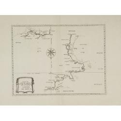
Carte particuliere des costes de Poittou, Aunis et de la Rochelle.
Finely designed and rare map of Isle Ré and the French coast with La Rochelle.
- $1250 / ≈ €1170
Place & Date: Amsterdam, c. 1750
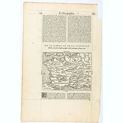
Page from La Cosmographie Universelle with map of France. (Page 160)
Text page with woodblock map of ancient France (122 x 163 mm.) In 1575 Sebastian Münster's Cosmographia was translated into French and published in Paris by François d...
- $75 / ≈ €70
Place & Date: Paris, 1575

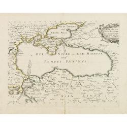
Black Sea.
Decorative steel engraved map of the Black Sea with inset views of Sebastopol and Odessa. There are also vignettes of Constantinople, Sinope and Varna. Taken from "T...
- $90 / ≈ €84
Place & Date: London, London Printing and publishing Company of London, ca. 1851
Carte de France corrigée par ordre du Roy sur les observations de Messieurs de l'Académie des Sciences
Important map published by the Academy of Sciences. The new projection method was based on the necessary to define the exact contours of the country and to develop the me...
- $3000 / ≈ €2807
Place & Date: Paris, 1693
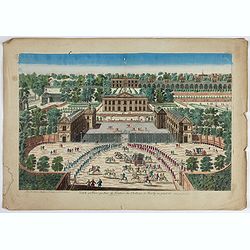
Veuë et Pers-pective de l'Entrée du Château de Marly en général.
A rare panoramic view of the Château de Marly (Marly-le-Roi) by Aveline. The plate, at the joint address of Esnault et Rapilly and Daumont, is numbered in upper right co...
- $250 / ≈ €234
Place & Date: Paris, c. 1760
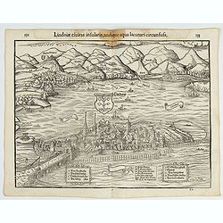
Lindoiae civitas insularis, undique aqua lacunari circunsusa.…
A wood block printed early bird's-eye view of Lindau on Lake Constance (Germany). A lettered key A-O in the plate. From the 1552 Latin text edition of Münster's Cosmogra...
- $70 / ≈ €66
Place & Date: Basel, 1552
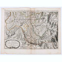
La Savoia divisa nelle sue Principali Provincie da Giacomo Cantelli da Vignola . . .
Late 17th century maps of the Savoy region, based on the reports of Giacomo Cantelli da Vignola and published in Roma in Giacomo de Rossi's world atlas Mercurio Geografic...
- $250 / ≈ €234
Place & Date: Rome, 1692
Disegno Idrografico del Canale Reale . . .
A decorative Coronelli map showing the Canal du Midi. It shows the extent of the canal from the Mediterranean sea at Narbonne to Toulouse. Featuring a pair of large coats...
- $300 / ≈ €281
Place & Date: Venice, 1695-1697

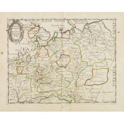
Regionis Biturigum... Per Ioannem Calamaeum. / Limaniae Topographia Gabriele Symeoneo Auct.
Two maps on one sheet. Biturigum. The Loire river is at the right in central France. Neuers (Nevers) is at the middle of the right margin. Bourges is near the center, an...
- $125 / ≈ €117
Place & Date: Antwerp, ca. 1598
![[Lot of 7 leaves] Curiensis civitas, Rhetorum…/Valesia/Solothurensis/Clarissimae civitatis/Genevensis/Basiliensis/Ursina…Bernensis/Sedunensis/Designatio …Badensis.](/uploads/cache/48278-250x250.jpg)
[Lot of 7 leaves] Curiensis civitas, Rhetorum…/Valesia/Solothurensis/Clarissimae civitatis/Genevensis/Basiliensis/Ursina…Bernensis/Sedunensis/Designatio …Badensis.
Seven text leaves illustrated with wood block bird's-eye views of Chur, Solothurn, Geneva, Basel, Bern, Sitten, Baden and one single sheet map of the Valais. From the 155...
- $400 / ≈ €374
Place & Date: Basel, 1552
![[Lot of 25 leaves of France, Brabant, Netherlands, Luxemburg]](/uploads/cache/48264-250x250.jpg)
[Lot of 25 leaves of France, Brabant, Netherlands, Luxemburg]
Twenty-five text leaves with wood block illustrations relating to France, Brabant, the Netherlands, Luxemburg. From the 1552 Latin text edition of Münster's Cosmographia...
- $100 / ≈ €94
Place & Date: Basel, 1552
![[Lot of 2 leaves] Vienna Austriae metropolis, urbs…](/uploads/cache/48268-250x250.jpg)
[Lot of 2 leaves] Vienna Austriae metropolis, urbs…
A wood block printed early panoramic view of Vienna (Austria). From the 1552 Latin text edition of Münster's Cosmographia, which is a short and complete summary of Renai...
- $50 / ≈ €47
Place & Date: Basel, 1552
![[Lot of 2 leaves] Rubeaquum cum arce Isenburgo…/ Wyssenburg…](/uploads/cache/48269-250x250.jpg)
[Lot of 2 leaves] Rubeaquum cum arce Isenburgo…/ Wyssenburg…
Two wood block printed early bird's-eye views of Rouffach (lies along the Alsatian wine route) and Wissembourg (Alsace). From the 1552 Latin text edition of Münster's Co...
- $100 / ≈ €94
Place & Date: Basel, 1552
![[Pictorial map of Georgia (Caucasus)].](/uploads/cache/44292-250x250.jpg)
[Pictorial map of Georgia (Caucasus)].
A scarce pictorial map of a region in Georgia in the Caucasus. Map is entirely in Russian, complete with legend at base of map, with small thumbnail pictures and symbols ...
- $150 / ≈ €140
Place & Date: Moscow, 1963
Contado DE Venassino, E prencipato d'Oranges . . .
A most attractive and decorative map centered on Avignon and Orange, by Vincenzo Coronelli. An elaborate title cartouche garlanded with intertwined flowers and dedicated ...
- $400 / ≈ €374
Place & Date: Venise 1690

Plan du Golfe et des Caps de St. Tropez. par Jacques Ayrouard . . .
Large plan of the harbour St. Tropez. Decorated with a large compass rose.From the rare chart book by Jacques Ayrouard: "Recueil de plusieurs plans des ports et rade...
- $300 / ≈ €281
Place & Date: Marseille, 1732-1746
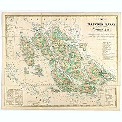
Karta öfver Färentuna härad eller det fordom så kallade Svartsjö län,
Fine and detailed map prepared by Victor Dahlgren (1815-1870).
- $200 / ≈ €187
Place & Date: Stockholm, 1853
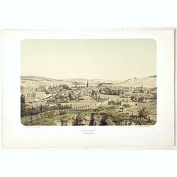
COMMERCY, Vue prise de la Garenne - Chemins de fer de l'Est. Dessiné d'après nat. et Lith. par A.Maugendre.
Original lithograph eye-bird view of Commercy, as seen from La Garenne. Lithographed by Jules Monthelier (1801-1883) and Adolphe-Jean-Baptist Bayot (Alessandria 1810 - 18...
- $125 / ≈ €117
Place & Date: Paris, 1844

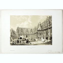
PORTAIL SEPTENTRIONAL DE LA CATHÉDRALE A CHARTRES. Dessiné d'après nature par Monthelier. Lith. par Monthelier.fig. par Bayot.
Original lithograph of the northern portal of Chartres cathedral. Lithographed by Jules Monthelier (1801-1883) and Adolphe-Jean-Baptist Bayot (Alessandria 1810 - 1866) af...
- $75 / ≈ €70
Place & Date: Paris, 1844

ARC DE TRIOMPHE A ORANGE. Dessiné d'après nature par Guesdon. Lith. par Ad. Cuvellier. Fig. par Bayot.
Original lithograph of the Triumph Arc of Orange. Lithographed by A. Cuvillier and Adolphe-Jean-Baptist Bayot (Alessandria 1810 - 1866) after a design by Chapuy and print...
- $100 / ≈ €94
Place & Date: Paris, 1844
PALAIS DE JUSTICE A ROUEN. Dessiné d'après nature par Chapuy. Lith. par Rouargue.
Original lithograph of the courthouse of justice in Rouen. Lithographed by Rouargue after a design by Chapuy and printed in Paris by Lemercier, Bernard Cie.
- $150 / ≈ €140
Place & Date: Paris, 1844

INTERIEUR DE LA CATHEDRALE A CHARTRES. Dessiné d'après nature par Chapuy. Lith. Par Bachelier.
Original lithograph of the inside of the cathedral situated in Chartres. Lithographed by Bachelier after a design by Chapuy and printed in Paris by Lemercier, Bernard Cie...
- $35 / ≈ €33
Place & Date: Paris, 1844

TOMBEAU DU DUC DE BREZE, DANS LA CATHEDRALE DE ROUEN. Dessiné d'après nature par Chapuy. Lith. par Monthelier. Fig. par Bayot.
Original lithography of the tomb of the duke of Brézé, in the cathedral of Rouen. Lithographed by Jules Monthelier (1801-1883) and Adolphe-Jean-Baptist Bayot (Alessandr...
- $50 / ≈ €47
Place & Date: Paris, 1844

ÉGLISE St. VINCENT A ROUEN. Dessiné d'après nature par Chapuy. Lith. par Monthelier. Fig. par Bayot.
Original lithograph of St Vincent cathedral, situated in Rouen. Lithographed by Jules Monthelier (1801-1883) and Adolphe-Jean-Baptist Bayot (Alessandria 1810 - 1866) afte...
- $80 / ≈ €75
Place & Date: Paris, 1844

INTERIEUR DE L'EGLISE SAINT OUEN A ROUEN. Dessiné d'après nature par Chapuy. Lith. Par Arnout. Fig par Bayot.
Original lithograph of the inside of Saint Ouen chruch, situated in Rouen. Lithographed by Arnout and Adolphe-Jean-Baptist Bayot (Alessandria 1810 - 1866) after a design ...
- $50 / ≈ €47
Place & Date: Paris, 1844

FACADE DE LA CATHÉDRALE A CHARTRES. Dessiné d'après nature par Chapuy. Lith. par Deroy.
Original lithograph of Chartres Cathedral's facade. Lithographed by Deroy after a design by Chapuy and printed in Paris by Lemercier, Bernard Cie.
- $125 / ≈ €117
Place & Date: Paris, 1844

ÉGLISE SAINT OUEN, A ROUEN. Dessiné d'après nature par Chapuy. Lith. par Deroy.
Original lithograph of Saint Ouen cathedral, situated in Rouen. Lithographed by Deroy after a design by Chapuy and printed in Paris by Lemercier, Bernard Cie.
- $125 / ≈ €117
Place & Date: Paris, 1844

Guide de Florence et de ses environs Redige´ sur un plan entierement nouveau par l'Abbé A. Bulgarini et Traduit en français par A. Le Rendu. Deuxième édition.
Second edition. With 1 engr. folding plan (Pianta della Citta di Firenze. I. Balatri inc. e scris.) and 12 copper plates with views in Florence. The folding plan has meas...
- $550 / ≈ €515
Place & Date: Florence, Gaspard Ricci, 1839
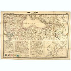
Carte d'Orient par Kraminski ingénieur.
Large map of Orient, with an insert of four maps (Constantinople plan - Map of Europe - Map of Russia - Plan of Baltic sea). With flags in the lower left part. color key ...
Place & Date: Paris, 1854
Mer Noire ou Mer Maievre, . . .
Map of the Black Sea prepared by N.Sanson and published by Pierre Mariette.Published in an early edition of the small Sanson atlas L'Europe Dediée a Monseigneur . . . Le...
Place & Date: Paris, P. Mariette, 1667
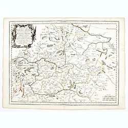
Partie de Lithuanie ou sont en partie les Palatinats de Wilna, et Troki, subdivisés en leurs Chastellenies et partie du Palatinat de Minsk.
Fine map of Lithuania. This edition carries the date 1665 and the publishers address "A Paris, chez Pierre Mariette, rue Saint Jacques a l'Esperance…"Nicolas ...
Place & Date: Paris, 1666
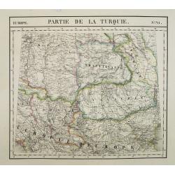
Europe. Partie de la Turquie. N°21.
Detailed map including Hungary and Romania.From his famous Atlas Universel . This atlas was one of the most remarkable world atlases ever produced, anticipating the Inter...
Place & Date: Brussels, 1825-1827
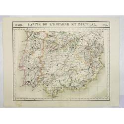
Europe. Partie de l'Espagne et Portugal. N°24.
Detailed map including Southern part of Spain and Portugal.From his famous Atlas Universel . This atlas was one of the most remarkable world atlases ever produced, antici...
Place & Date: Brussels, 1825-1827
Espagne. . .
Map of Spain and Portugal prepared by N.Sanson and published by Pierre Mariette.Published in an early edition of the small Sanson atlas L'Europe Dediée a Monseigneur . ....
Place & Date: Paris, P. Mariette, 1667
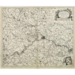
Comitatus Namurci Emendata Delineatio, Nuperrimè in lucem edita, per Nicolaum Visscher.
Detailed engraved map of the province of Namur (Namen), showing cities including Charleroi and Dinant., towns, rivers and lakes. Decorative cartouche with putti. Explanat...
Place & Date: Amsterdam, 1684
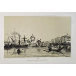
Cathédrale d'Isaac et Palais du Sénat. Vue prise de la Néva. (17 juillet 1839).
A view from the port of the Isaac Cathedral and the Senat Palace in Saint Petersburg on July 17 1839. Plate taken from the first illustrated account of Russian architectu...
Place & Date: Paris, 1845
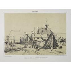
Village sur la route de Moscou. (9 Août 1839).
A view of a village on the way to Saint Petersburg on August 9 1839. Plate taken from the first illustrated account of Russian architecture. This publication was the proj...
Place & Date: Paris, 1842

Palais de Paul 1er. Côté du Jardin d'Eté. (16 Juillet 1839).
A view of Paul the First Palace in Saint Petersburg on August 9 1839. Figures are lithographed by Raffet. Plate taken from the first illustrated account of Russian archit...
Place & Date: Paris, 1844
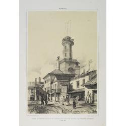
Tour d'Observation et siège de police dans la grande Morskoi. (2 Juillet 1839).
A view of Observation Tower and police headquarters in the Morskoi in Saint Petersburg on August 9 1839. Plate taken from the first illustrated account of Russian archite...
Place & Date: Paris, 1840
Selling price: $250
Sold in 2013

Les Trois Temples de Pestum. Royaume de Naples.
Uncommon and decorative lithography of the Temples of Paestum near Naples. Published by Carl Johan Billmark and printed by Lemercier in Paris, 55 rue de Seine, the leadin...
Place & Date: Paris, c.1859

Lac de Nemi (environs de Rome).
Uncommon and picturesque lithography of Lake Nemi, a small circular volcanic lake in the Lazio region, 30 kilometers south of Rome. Published by Carl Johan Billmark and p...
Place & Date: Paris, c.1859
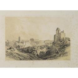
Rome. Vue prise du Mont Palatin.
Uncommon and picturesque lithography of Rome. View from Mount Palatin. Published by Carl Johan Billmark and printed by Lemercier in Paris, 55 rue de Seine, the leading fi...
Place & Date: Paris, c.1859
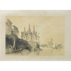
S. Maria della Spina (à Pise).
Uncommon lithography of the Church of S. Maria della Spina in Pisa. Published by Carl Johan Billmark and printed by Lemercier in Paris, 55 rue de Seine, the leading firm ...
Place & Date: Paris, c.1859
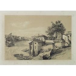
Rome (Ponte Rotto).
Uncommon and picturesque lithography of Rome with a view of the Rotto Bridge. Published by Carl Johan Billmark and printed by Lemercier in Paris, 55 rue de Seine, the lea...
Place & Date: Paris, c.1859

Lac de Garda Vue prise à Teno.
Uncommon and picturesque view of the Garda lake from the town of Teno. Published by Carl Johan Billmark and printed by Lemercier in Paris, 55 rue de Seine, the leading fi...
Place & Date: Paris, c.1859
Lac d'Averne (Roye. De Naples).
Uncommon and picturesque lithography of the Lake Avernus (Lago d'Averno). It was believed to be the entrance to the underworld, and is portrayed as such in the Aeneid of ...
Place & Date: Paris, c.1859
Pont du Crevola au pied de Simplon (Italie).
Uncommon and picturesque lithography of the Crevola Bridge at the foot of the Simplon Mountain in Italy. Published by Carl Johan Billmark and printed by Lemercier in Pari...
Place & Date: Paris, ca.1859
Savona Golfe de Gênes.
Uncommon and picturesque view of Sanova in the northern Italian region of Liguria in the Riviera di Ponente on the Mediterranean Sea. Published by Carl Johan Billmark and...
Place & Date: Paris, ca.1859
Rome. Les Trois colonnes de Grecostatis, et le Forum Romanum.
Uncommon and picturesque lithography of the Forum Romanum in Rome. On foreground the remains of the Temple of Castor and Pollux.Published by Carl Johan Billmark and print...
Place & Date: Paris, c.1859

Subiaco. Environs de Rome.
Uncommon and picturesque view of Subiaco in the Province of Rome, in Lazio. Subiaco is famous as it was the first city in Italy where books were printed, in the 15th cent...
Place & Date: Paris, ca.1859
Russie Blanche ou Moscovie.
Map of the European part of Russia prepared by N.Sanson and published by Pierre Mariette.Published in an early edition of the small Sanson atlas L'Europe Dediée a Monsei...
Place & Date: Paris, P. Mariette, 1667
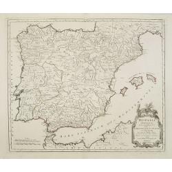
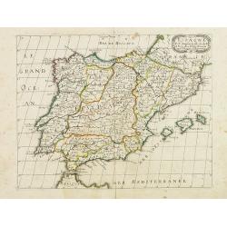
Hispania Antiqua in tres praecipuas partes..
Map of the Hibernia peninsula and the Balearic Islands. With a rococo title cartouche in the lower right corner.Venetian edition of Giles Didier Robert De Vaugondy's map ...
Place & Date: Venice, 1776 - 1784
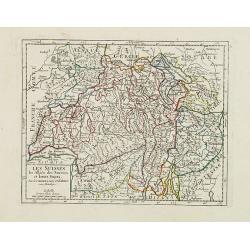
Les Suisses, les Alliés des Suisses et leurs Sujets.
Small detailed map of Switzerland. From Atlas Portatif Universel, by Robert de Vaugondy.Unrecorded state with erased date. Page 31 outside border top right. Mary Sponberg...
Place & Date: Paris, later than 1749
Flandria Gallica Continens Castellanias Insulense . . .
No text on verso. Map of northern part of France, centered on Lille and part of Belgium.
Place & Date: Amsterdam, c. 1660
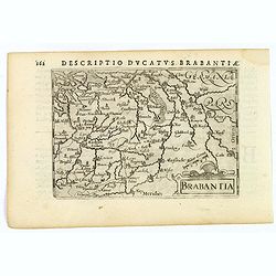
Brabantia.
A lovely miniature map of the Duchy of Brabant, published by Petrus Bertius, in Amsterdam at the beginning of the seventeenth century. There is a nice, small strap-work t...
Place & Date: Amsterdam, 1606
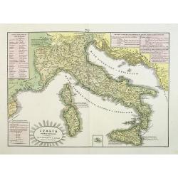
L'Italia antica-romana.
A rare and detailed double-page map of ancient Italy. According to the title cartouche, prepared by A de La Sage for l'Atlante Storico, Letterario, Biografico, Archeologi...
Place & Date: Venice, 1840
![Valona [ View of Valona]](/uploads/cache/45215-250x250.jpg)
Valona [ View of Valona]
Very rare view of Vlora in Albania published in the first edition of "Viaggio da Venetia, a Costantinopoli. Per Mare, e per Terra, & infieme quello di Terra Sant...
Place & Date: Venice, Giacomo Franco, 1598
IV. Carte du Duché de Luxembourg où sont les Seign.ries de Lompré..
Charming small map representing part of Luxembourg, the southernmost province of Wallonia and of Belgium.From Atlas Portatif Universel, by Robert de Vaugondy. Edited by :...
Place & Date: Paris, later than 1749
Partie de Lithuanie ou est en partie le Palatinat de Nowogrodeck Litawiski, subdivisé en leurs Chastellenies , le Palatinat de Bressici en Polesie, avec les duchés de Neswies, et Slusck, et partie du Palatinat de Minsk.
Scarce regional map, centered on Pinsk and showing Polish Lithuania, including part of modern Poland, Belarus, etc. This edition carries the date 1665. Nicolas Sanson was...
Place & Date: Paris, 1665
![Venetia. [Venice ]](/uploads/cache/45176-250x250.jpg)
Venetia. [Venice ]
Very rare view of Venice published in the first edition of "Viaggio da Venetia, a Costantinopoli. Per Mare, e per Terra, & infieme quello di Terra Santa. Da Gios...
Place & Date: Venice, Giacomo Franco, 1598
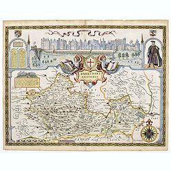
Berkshire Described.
A lovely map of Berkshire from the first Sudbury & Humble edition of John Speed’s “Theatre of the Empire of Great Britain”. The top of the map shows a panoramic...
Place & Date: London, 1612
![[View of Caorle].](/uploads/cache/45190-250x250.jpg)
[View of Caorle].
Very rare view of Caorle, at the time an island, published in the first edition of "Viaggio da Venetia, a Costantinopoli. Per Mare, e per Terra, & infieme quello...
Place & Date: Venice, Giacomo Franco, 1598
![[View of Gulf of Trieste].](/uploads/cache/45191-250x250.jpg)
[View of Gulf of Trieste].
Very rare view of Gulf of Trieste published in the first edition of "Viaggio da Venetia, a Costantinopoli. Per Mare, e per Terra, & infieme quello di Terra Santa...
Place & Date: Venice, Giacomo Franco, 1598
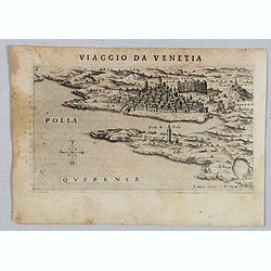
Polla Querrner [Pula in southern Istria)
Very rare view of Pula in southern Istria, published in the first edition of "Viaggio da Venetia, a Costantinopoli. Per Mare, e per Terra, & infieme quello di Te...
Place & Date: Venice, Giacomo Franco, 1598
![[San Nicola, Tremiti islands, in Italy. ]](/uploads/cache/45204-250x250.jpg)
[San Nicola, Tremiti islands, in Italy. ]
Very rare view of San Nicola, Tremiti islands, in Italy, published in the first edition of "Viaggio da Venetia, a Costantinopoli. Per Mare, e per Terra, & infiem...
Place & Date: Venice, Giacomo Franco, 1598
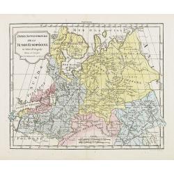
Partie Septentrionale de la Russie Européenne . . .
Detailed map of European part of Russia, including Finland and Lapland.
Place & Date: Paris, 1780
![VIII. Carte de l'Etat de Genes [. . .] Toscane.](/uploads/cache/24551-250x250.jpg)
VIII. Carte de l'Etat de Genes [. . .] Toscane.
Detailed small map showing an area straddling the provinces of Genoa, La Spezia, Parma and Massa Carrara, Tuscany.Relief shown pictorially. From Atlas Portatif Universel,...
Place & Date: Paris, later than 1748
![[ View of Cruzola]](/uploads/cache/45205-250x250.jpg)
[ View of Cruzola]
Very rare view of Tremite Islands Island published in the first edition of "Viaggio da Venetia, a Costantinopoli. Per Mare, e per Terra, & infieme quello di Terr...
Place & Date: Venice, Giacomo Franco, 1598
![[ View of Ragusi]](/uploads/cache/45206-250x250.jpg)
[ View of Ragusi]
Very rare view of Ragusa published in the first edition of "Viaggio da Venetia, a Costantinopoli. Per Mare, e per Terra, & infieme quello di Terra Santa. Da Gios...
Place & Date: Venice, Giacomo Franco, 1598
![Scutari [View of Shkodër - Albania]](/uploads/cache/45213-250x250.jpg)
Scutari [View of Shkodër - Albania]
Very rare view of Shkodër or Shkodra, historically known as Scutari or Scodra, is a city in the Republic of Albania. It is the capital of the surrounding county of Shkod...
Place & Date: Venice, Giacomo Franco, 1598
![Antivari [View of Bar in Montenegro]](/uploads/cache/45214-250x250.jpg)
Antivari [View of Bar in Montenegro]
Very rare view of Bar in Montenegro published in the first edition of "Viaggio da Venetia, a Costantinopoli. Per Mare, e per Terra, & infieme quello di Terra San...
Place & Date: Venice, Giacomo Franco, 1598
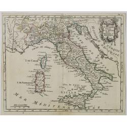
Carte d' Italie . . .
Map of Italy from Atlas moderne portatif composé de vingt-huit cartes sur toutes les parties du globe terrestre .. A l'usage des Colléges, des Pensions & des Maison...
Place & Date: Paris, Prudhomme, Levrault, Debray, 1806
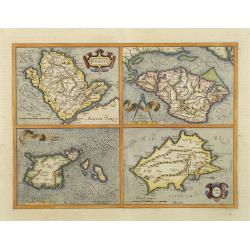
Anglesey. / Iarsay. / Carnesay. / Wight Vectis Olim.
Four maps on one sheet depicting the English islands Jersey, Guernsey, Wright and Alderney.
Place & Date: Amsterdam, 1629
![[Portrait] - Me De Cet Corona se X+I. - Contantia et Fortudine](/uploads/cache/43510-250x250.jpg)
[Portrait] - Me De Cet Corona se X+I. - Contantia et Fortudine
Portrait of German Emperor Charles VI with his motto "Contantia et Fortudine". Holy Roman Emperor, 1711-1740, and King of Hungary as Charles III (1712-1740). Wi...
Place & Date: Germany, 1740
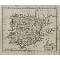
L' Espagne et le Portugal . . .
Map of Spain and Portugal, from Atlas moderne portatif composé de vingt-huit cartes sur toutes les parties du globe terrestre .. A l'usage des Colléges, des Pensions &a...
Place & Date: Paris, Prudhomme, Levrault, Debray, 1806
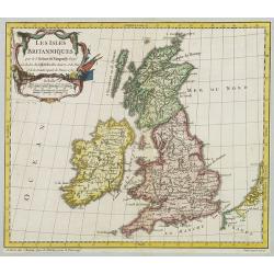
Les Isles Britanniques..
A first state (of 2) dated 1762. Fine map of the British Isles, engraved by E.Dussy. Fine title cartouche upper left engraved by Arrivet. From his Nouvel Atlas Portatif .
Place & Date: Paris, 1762
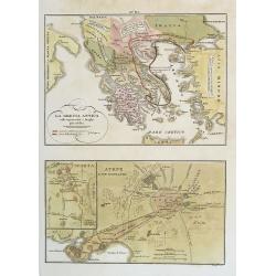
La Grecia Antica . . . / Atene e sue vicinanze . . .
Two rare maps, one of Greece map 175 x 240mm. and the other of Athens 140 x 240mm. with an inset map of Sparta.From l'Atlante Storico, Letterario, Biografico, Archeologic...
Place & Date: Venice, 1840
![[L'Hermite's fleet moors in the Solent for repairs.]](/uploads/cache/40472-250x250.jpg)
[L'Hermite's fleet moors in the Solent for repairs.]
In March 1623, a heavily armed fleet of 11 ships, under the command of Jacob l’Hermite, sailed from Holland with the ambitious hope of ‘destroying the Spanish in Amer...
Place & Date: Frankfurt, M.Merian, 1633