Search Listings matching "curated-collection" in Map Types

.Pascaerte Van't Westelyckste der Middelandsche Zee. . .
An eye-catching chart of the western part of the Mediterranean Sea.Pieter Goos (ca. 1616-1675) was one of the most important cartographer, engraver, publisher and print s...
Place & Date: Amsterdam, 1666

Paskaerte Vande Bocht van Vranckrijk Biscajen en Galissen
An eye-catching chart of Spain and France, including a large part of Brittany, including Isle de Reé , Isle Saint Martin ...Shows the gulf of the northeast Atlantic Ocea...
Place & Date: Amsterdam, 1669-1676

Eastern passage to China. sheet 1.
James Horsburgh early chart of the coasts of Java, Bali, Lombok, with part of Sulawesi, and Borneo. Insets of "Sketch of Bally Strait", Sketch of Lombock Strait...
- $2500 / ≈ €2339
Place & Date: London, 1824

Pascaarte van een deel der Oost Zee, tusschen Bornholm ende der Memel, vertonende de ware gelegentheijt der Zeecusten van Pruijssen. . .
This very rare chart of the Northern Coast of Poland with Gdansk, appeared in the rare English edition of Willem Blaeu's 'Het Licht der Zeevaert', an atlas of sea charts ...
- $4000 / ≈ €3743
Place & Date: Amsterdam, 1608

A plat of the East Sea. By William Fisher and Richard Mount...
An important sea chart of the East Sea with coast lines of Poland, Russia, Sweden, published by William Fisher and Richard Mount in London.Richard Mount (1654-1722) was a...
- $1800 / ≈ €1684
Place & Date: London, 1795

Pas-Caart van de Oost Zee verthooende alle de ghelegenheydt tusschen t Eylandt Rugen ende Wyborg. . .
An eye-catching chart of the Baltic Sea. Engraved by Gerard Coeck.Pieter Goos (ca. 1616-1675) was one of the most important cartographers, engravers, publishers and print...
- $1500 / ≈ €1404
Place & Date: Amsterdam, 1666
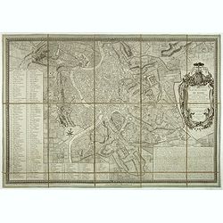
Plan de la ville de Rome, d'après celui publié par J.B. Nolli . . .
Beautiful town-plan of Rome, drawn up after the famous plan of Rome, executed by Giambattista Nolli in 1748. Decorated with a beautiful title cartouche topped by the coat...
- $1000 / ≈ €936
Place & Date: Paris, Jean, 1801

Plan de St. Jean de Luz avec les différents projets d'agrandissem.t du port.
Very rare and beautiful plan of the city and bay of Saint-Jean-de-Luz, detailing the projects of expansion of the port undertaken in 1780.The plan indicates the Artha Roc...
- $2000 / ≈ €1871
Place & Date: Paris, 1784

Mare Balticum. . . / Nieuwe Pascaert van de Oost Zee. . .
Decorative chart showing the Baltic sea, with a splendid cartouche of royal figures. A re-issue of the De Wit copper plates, now with many improvements.
- $2500 / ≈ €2339
Place & Date: Amsterdam ca.1680

Nieuwe gelyk Graadige Paskaart van de Kust van Guiana in West-Indien.
Detailed chart of Guiana in South America. Two scales are given in both maps: Dutch, French and English nautical miles.The inset chart provide detailed view of the Camopi...
- $650 / ≈ €608
Place & Date: Amsterdam, 1684 - 1704

Pascaerte van Carybes, Nieu Neder landt, Brazil. . .
This progenitor chart covers the American shores of the Atlantic Ocean. This chart by Theunis Jacobsz. was most probably engraved close to his death in 1650 or shortly af...
- $2200 / ≈ €2059
Place & Date: Amsterdam, 1653-1681

Noordoost Cust van Asia van Japan tot Nova Zembla.
Important for its early depiction of Hokkaido and the Islands to the North of Japan. Ships navigate the seas around the Siberian, Chinese and Japanese coast extending as ...
- $3000 / ≈ €2807
Place & Date: Amsterdam, 1666
Madrid Villa Capital Del Reyno D'Espana.. / Madrid ville capitale du Royaume d'Espagne . . .
A very decorative and scarce town view of Madrid, including a numbered key ( 1-17 ) in Spanish and French in the lower part. Published by Jacques Chéreau, (1688 - 1776)....
- $3000 / ≈ €2807
Place & Date: Paris, ca.1750
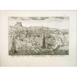
Barcelone, Ville Capitale de la principauté Catalogne. . .
A very decorative and scarce view of Barcelona, including a numbered key ( 1-29 ) in the lower part. Published by Jacques Chéreau, (1688 - 1776). Engraved by Aveline and...
- $3000 / ≈ €2807
Place & Date: Paris, ca.1750
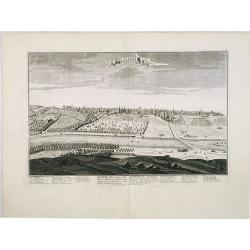
Seville. Ville Archiepiscopale et Capitale du Raume d'Andalousie en Espagne. . .
A very decorative and extremely rare view of Seville, including a numbered (1-37) key in the lower part. Published by Jacques Chéreau, (1688 - 1776). Engraved by Aveline...
- $3000 / ≈ €2807
Place & Date: Paris, ca.1750
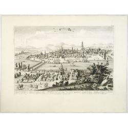
![Praghe. [ Prague ]](/uploads/cache/27801-250x250.jpg)
Praghe. [ Prague ]
A rare panoramic of Prague with over the whole length of the lower part 3 columns of poems in Dutch, French, German and English.Frederick de Wit published after 1694 a t...
- $2000 / ≈ €1871
Place & Date: Amsterdam, 1694
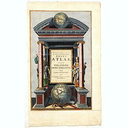
Joannis Janssonii Novus Atlas, sive Theatrum Orbis Terrarum: in quo Orbis Antiquus. . .
A glorious mid-seventeenth century engraved frontispieces to atlas by Janssonius. Finely decorated with a pair of terrestrial (bottom) and celestial (top) globes and the ...
Place & Date: Amsterdam, 1650

Kaart van Het Noordelijk Gedeelte Van Het Eiland Borneo.
A very detailed map of Northern Borneo including Brunei, taken from the "Atlas der Nederlandsche bezittingen in Oost-Indië", which was published by Departement...
- $750 / ≈ €702
Place & Date: The Hague, 1883-1885

Kaart van de Gaspar Straaten volgens opnemingen van J.Stolze, D.Ross, enz.
Very large and rare chart centered on the strait between Bangka's southeastern seacoast and Belitung's western shores.Short front views of the coastal relief are shown in...
- $900 / ≈ €842
Place & Date: Amsterdam 1843
![[Set of five maps] Carte Générale de la Terre ou Mappe Monde](/uploads/cache/41145X-250x250.jpg)
[Set of five maps] Carte Générale de la Terre ou Mappe Monde
Rare and decorative set of five wall maps of the world and the four continents, prepared by Clouet, in very fine bright contemporary coloring. Each map ca. 965 x 1230 mm ...
Place & Date: Paris and Cadiz, Mondhare, 1785-1793

Composite atlas of the Low Countries.
A composite atlas comprising 18 double-page engraved maps by or after Hessel Gerritsz, Theodoor Galle, Jacob van Deventer, Gerard Mercator, Peter Verbiest, Jean Surhon, C...
Place & Date: [Antwerp, c. 1633

Original copperplate.
Showing the coast of southern Morocco, the Sahara with the Canary Islands. Copperplates that had been used in the production of early maps are of the greatest rarity and ...
Place & Date: Amsterdam, ca. 1660

Mercurius.
Mercury holding a caduceus and riding in a chariot drawn by two birds on the clouds in the sky, an extensive landscape with a harbor with goods being loaded and unloaded ...
Place & Date: Antwerp, 1585

Lapis polaris magnes.
This is a plate from a series of twenty prints illustrating new inventions and discoveries (Nova Reperta) after Jan van der Straet. On image, bottom right: 'Ion. Stradanu...
Place & Date: Antwerp, Philips Galle, c. 1590

Nova XVII Provinciarum Inferioris Germaniae descriptio .
Extremely rare map of the Benelux by Frederick de Widt. Originally engraved and published by P.Kaerius in 1607. In 1662 the plate came in the possession of Frederick de W...
Place & Date: Amsterdam, 1662

Nieuwe en zeer accuraate Zee-Caart van de Hollandse Wal strekkende van de Maas tot Texel opgenomen door Jan Rokusz Douw, , ,
A very fine and rare chart of the coast of Holland, Prepared by Jan Rokusz, Douw and Agge Roskam Kool.Embellished with a very decorative cartouche with a dedicational tex...
Place & Date: Amsterdam, 1750

Ducatus Prussiae tam Polono Regiae. . .
This is a rare issue of Frederick de Wit's attractive map of the northern part of Poland, Prussia and the Baltic regions.Very decorative title cartouche, including three ...
Place & Date: Amsterdam, 1698

Nieuwe en Nette Afteekening van het Eyland Corsica en het Eyland Elba vertoonende alle desselfs Havenen, Steeden en Rivieren . . .
Highly decorative large sea chart of Corsica, Sardinia and Elba, including multiple sailing ships, compass roses, cartouche, coat of arms, rhumb lines, topographical deta...
Place & Date: Amsterdam, ca. 1710

Germania.
Second state of this rare "carte à figures"- map of Germany, The Netherlands, Poland and central Europe. Bordered on three sides with portraits and views. In t...
Place & Date: Amsterdam, 1607

Straat Riouw onder opzicht van de commissie tot verbetering der Indische Zeekaarten..
Very large and rare so-called Blue Back centered on the strait passing between the Riau Islands. It contains an inset map with enlarged details of Riouw Harbor on Bintang...
Place & Date: Amsterdam 1843

Les Provinces confederées du Pais-Bas
The first wall map of the Seven Provinces of 1651, re-issued as 'Stoel des Oorlogs' by Covens & Mortier. The first issue of the present wall-map is known to be includ...
Place & Date: Amsterdam, c. 1740

Pas-kaart vande Zee kusten van Venecuela met de Byleggende Eylanden. . .
Rare chart of the coast of Venezuela, including the islands of Curaçao, Bonaire, Aruba, etc.The chart has two insets, one (15x22cm) with a map of Curaçao, one smaller w...
Place & Date: Amsterdam, 1680

North Pacific.
Huge three sheet so-called Blue-back sailing chart of the Northern Pacific including China, Korea (with Matu Is. and Liancourt), Japan, Philippines, Kamchatka, Hawaii, Al...
Place & Date: London, 1868
![Bressia vulgo Bresse. [colored by Van Santen]](/uploads/cache/29235-250x250.jpg)
Bressia vulgo Bresse. [colored by Van Santen]
Title cartouche with putti and surveyor with surveying instruments. Upper right-hand corner Geneva, lower left Lyon and in the center Bourg-en Bresse. Upper right-hand co...
Place & Date: Amsterdam, 1650