Browse Listings
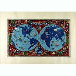
AIR France - Sur les ailes d'Air France découvrez le monde à votre tour.
Promotional poster of a double hemisphere world map designed by Lucien Boucher for AIR France. The map depicts the entire world in rich blues and burgundies with gold hig...
Date: Perceval, Paris, 1952
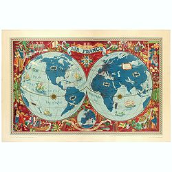
AIR France - Sur les ailes d'Air France découvrez le monde à votre tour.
Promotional poster of a double hemisphere world map designed by Lucien Boucher for AIR France. The map depicts the entire world in rich blues and burgundies with gold hig...
Date: Perceval, Paris, 1952
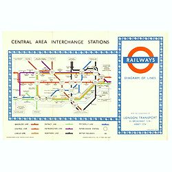
1953 Harry Beck London Underground map.
Published in the Queen's coronation year. A London Underground map (double sided).
- $150 / ≈ €127
Date: London, 1953
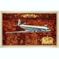
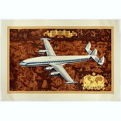
AIR France - Comet De Havilland
Promotional poster attributed to Lucien Boucher showing the Comet de Havilland on a Mercator projection world map. The map depicts a pictorial map of the entire world in ...
Date: Perceval, Paris, 1953
AIR France - Super constellation, Lockhead L - 10 - 49.
Promotional poster attributed to Lucien Boucher showing of a Lockhead L - 10 - 49 on a Mercator projection world map. The map depicts a pictorial map of the entire world ...
Date: Perceval, Paris, 1953
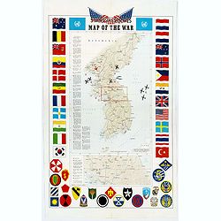
Pacific Stars and Strips Map of the War.
A detailed map of the Korean War. Several silhouetted flying military aircraft are shown in formation. The map shows the Korean Peninsula from its northern border with Ru...
Date: America, 1953
![AIR France [Planisphère Air France Zodiac].](/uploads/cache/46994-250x250.jpg)
AIR France [Planisphère Air France Zodiac].
A double-hemisphere celestial map with the constellations of the zodiac in gold and the others in turquoise, set against a sky of navy blue, both with the major stars mar...
- $2200 / ≈ €1870
Date: Imprimerie Perceval, Paris, 1953
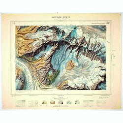
Aiguille verte - Chamonix N°6 Sud
Magnificent 1:10,000 scale color printed map of l'Aiguille verte (Chamonix N°6 Sud) based on stereotopographic ground and aerial surveys carried out in the field in 1950...
Date: Paris, 1953
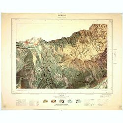
Servoz - Cluses N°8 Sud.
Magnificent 1:10,000 scale color printed map of Servoz (Cluses N°8 Sud) based on stereotopographic ground and aerial surveys carried out in the field in 1950 and render...
Date: Paris, 1953
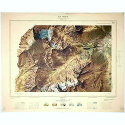
Le Buet - Chamonix N°1 Sud. / Massif des Aiguillles Rouges.
Magnificent 1:10,000 scale color printed map of Le Buet (Chamonix No. 1 South) / "Massif des Aiguilles Rouges" based on stereotopographic ground and aerial surv...
Date: Paris, 1953
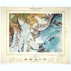
Aiguille du Midi - Mont Blanc N°1 Nord.
Magnificent 1:10,000 scale color printed map of L'Aiguille du Midi (Mont Blanc N°1 Nord) based on stereotopographic ground and aerial surveys carried out in the field in...
Date: Paris, 1953
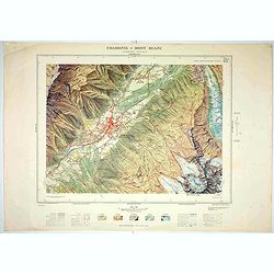
Chamonix - Mont Blanc - Chamonix N°5 Sud.
Magnificent 1:10,000 scale color printed map of Chamonix - Mont Blanc (Chamonix N°5 Sud) based on stereotopographic ground and aerial surveys carried out in the field in...
Date: Paris, 1953

(World map). Americus Vespucio novo te Duce Ducta Freto Ambivi Meritoqs Vocor.
Manuscript world map showing the American and African continent and the southern parts of Asia. In the Indian Ocean a large depiction of Amerigo Vespucci 1454 – 1512) o...
Date: Italy, ca. 1954
![[Set of 2 maps] The Pageant of History in Northern California its colorful and adventuresome beginnings / The Panorama of Today in Northern California its resources, activities and opportunities.](/uploads/cache/48343A-250x250.jpg)
[Set of 2 maps] The Pageant of History in Northern California its colorful and adventuresome beginnings / The Panorama of Today in Northern California its resources, activities and opportunities.
An unusual and attractive pair of lithographed maps, issued by the American Trust Company, in San Francisco on the occasion of its centenary in 1954. It chose to do this ...
- $350 / ≈ €297
Date: San Francisco, 1954
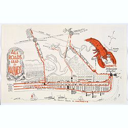
Map of Atlantic City to Hackney's Famous Garden of Sea Food . . .
A mid 1950s brochure for the famous Atlantic City Seafood Restaurant - 'Hackneys'. One side proclaims that "All Roads lead to Hackney's". It shows a nice plan o...
Date: New Jersey, ca 1954
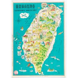
Illustrated map of Taiwan for tourist.
illustrated map of Taiwan for tourist. Pictorial map of Formosa published by Mei Kuang Art Company. Printed in English and Chinese. Features remarkable sites, various agr...
Date: Mei Kuang Art Company, 1954
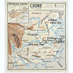
Chine - Angleterre.
A large, vintage French school poster map from the 1950s, showing China on one side and the United Kingdom on the reverse. As you would expect content and detail and basi...
Date: Nalliers, ca 1955
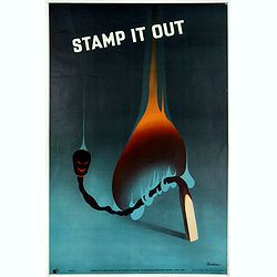
Stamp it out.
colorful 'Keep Alert" poster by Leonard Cusden (1950s), made for the "The Royal Society For The Prevention of Accidents" in London.Leonard Cusden (1928-193...
- $200 / ≈ €170
Date: London, ca. 1955
![Air France [poster].](/uploads/cache/44299-250x250.jpg)
Air France [poster].
A superb double-sided Air France folding poster, featuring bold colored graphics. Published as a serious piece of marketing put out by the airline showing off their state...
Date: Paris, 1955
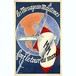
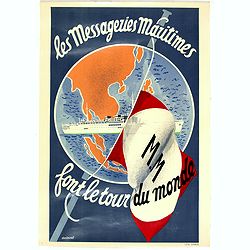
Les Messageries Maritimes font le tour du monde.
Original lithographed poster created by the artist Robert Louis Antral for Les Messageries Maritimes, showing a boat and a globe. Les Messageries Maritimes Company (MM) i...
- $900 / ≈ €765
Date: Paris, 1955
Les Messageries Maritimes font le tour du monde.
Original lithographed mini poster (570 x 400mm.) created by the artist Robert Louis Antral for Les Messageries Maritimes, showing a boat and a globe. Les Messageries Mari...
Date: Paris, 1955
![Air France [poster].](/uploads/cache/44696-250x250.jpg)
Air France [poster].
A superb double sided Air France folding poster, featuring bold colored graphics. Published as a serious piece of marketing put out by the airline showing off their state...
- $500 / ≈ €425
Date: Paris, 1955

Indonesia.
Original vintage travel advertising issued by the Indonesian Council for Tourism featuring a colorful pictorial map marking the islands and oceans with images of local pe...
Date: Jakarta, ca. 1955
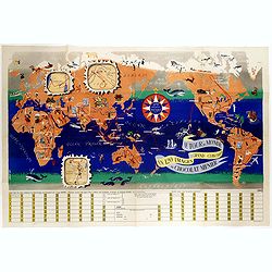
Le tour du monde en 120 images, grand concours du Chocolat Menier.
Pictorial map of the world centered on the Pacific with a route around the globe, starting and finishing in Paris. The map features 120 images of explorers, plants, anima...
Date: Paris, 1956
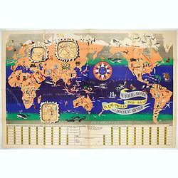
Le Tour du Monde en 120 Images Grand Concours du Chocolat Menier.
This highly unusual and rather novel pictorial map of the world was created by J.B. Jannot and published by Agence Française de Propagande as a promotional item for Meni...
Date: Paris, 1956
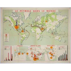
Le pétrole dans le monde.
FIRST EDITION: Poster published by the Union of Union Chambers of the Petroleum Industry. Large world map showing the oil fields in the world: United States, U.S.S.R., Ve...
Date: Paris, Imp. Lafayette. 1956
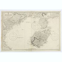
China sea. Tong King Gulf Compiled from the latest British and Foreign Government surveys to 1886. . .
Detailed Map of Chart of Annam Gulf or Tong King Gulf, in the China Sea. Chart with legend and scale. British Admiralty chart No. 2062, published June 1881, large correct...
- $400 / ≈ €340
Date: London, 1881 updated to 1957
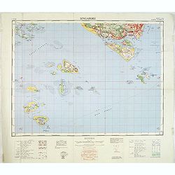
Singapore. - Sheet 134h Keppel harbour.
Map of Singapore. Map with legend and scale. According to a note "Prepared under the direction of the Surveyor General Malaya from the following sources materials : ...
- $750 / ≈ €637
Date: Kuala Lumpur, 1958
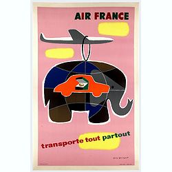
Air France transporte tout partout.
Nice poster designed by Guy Georget, promoting the freight service of Air France.Guy Georget (1911-1992), was a French poster designer and illustrator. Georget's first co...
Date: Perceval, Paris, 1958

AIR France - Le plus grand réseau du monde.
Created in 1959 by the artist Lucien Boucher, showing all of the DC-7 Air France Routes. The Blue Pink Poster is one of a series of eight posters commissioned by Air Fran...
Date: Imprimerie Perceval, Paris, 1959
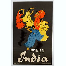
Festivals of India.
A large eye-catching poster of five women, dancing against a black background, dressed in stunning sari's of red, yellow and blue, produced in India by the Government, wi...
- $750 / ≈ €637
Date: Calcutta, 1959

Balinees watercolor on paper, fisherman.
Decorative export painting from Bali of a more than average quality.
- $150 / ≈ €127
Date: Bali, ca 1960

Balinees watercolor on paper, fishermen.
Decorative export painting from Bali of a more than average quality.
Date: Bali, ca 1960

Balinees watercolor on paper, fishermen.
Decorative export painting from Bali of a more than average quality.
- $150 / ≈ €127
Date: Bali, ca 1960

Forteresse Ile Ste Marguerite.
Nice drawing of a stronghold Ste Marguerite. The Île Sainte-Marguerite is the largest of the Lérins Islands, about half a mile off shore from the French Riviera town of...
Date: France, Provence, after 1960
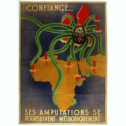
Ses Amputations se Poursuivent Methodiquement.
Propaganda map, produced under the NAZI collaborating Vichy French regime and designed to inspire revulsion and hatred of the English among the French, while frequently d...
Date: Paris, ca. 1941 / ca. 1960
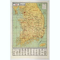
The Road Map of Southern Korea.
Offset printing. A large scale, comprehensive road map of South Korea, with a symbol legend and an inset map of 'The Republic of Korea', and inset of the island of Jeju D...
Date: Seoul, ca 1960
![[TAI travel poster]](/uploads/cache/44304-250x250.jpg)
[TAI travel poster]
A whimsical travel poster for "Transport Aeriens Intercontinentaux" (TAI), published in Paris in 1960, by Luc-Marie Bayle (1914-2000). The poster depicts a twin...
Date: Paris, 1960
![[Fan shaped shopping guide to Stockholm.]](/uploads/cache/44788-250x250.jpg)
[Fan shaped shopping guide to Stockholm.]
A highly unusual and interesting vintage fan-shaped map of Stockholm to illustrate a 'Shopping guide to Stockholm'. Text written in English. With ten fold-out panels prin...
Date: Stockholm, 1960
![[TAI travel poster]](/uploads/cache/44893-250x250.jpg)
[TAI travel poster]
A whimsical travel poster for "Transport Aeriens Intercontinentaux" (TAI), published in Paris in 1960, by Luc-Marie Bayle (1914-2000). The poster depicts a twin...
- $700 / ≈ €595
Date: Paris, 1960
![[TAI travel poster]](/uploads/cache/44894-250x250.jpg)
[TAI travel poster]
A whimsical travel poster for "Transport Aeriens Intercontinentaux" (TAI), published in Paris in 1960, design by François Lesourt (Périgueux, 1913 - 1997). Th...
Date: Paris, Hubert Baille & Cie Paris, 1960
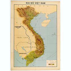
Dia-Do Viet-Nam.
Economic map of Vietnam published in 1960 (not for sale), gift from Japan paper committee. Scale : 1:2 400 000. With a key at lower right part.Features Vietnam, Cambodia,...
Date: 1960
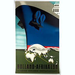
Holland-Afrika Lijn.
Original cruise ship travel poster promoting Holland-Afrika Lijn for the N.V. Veenigde Nederlandse Scheepvaarts Maatschappij. Great illustration by the Dutch graphic arti...
- $850 / ≈ €722
Date: Rotterdam, Kuhn & Zoon, ca. 1960
![[No title] Gouache of a class scene with globe, revolting students and a teacher.](/uploads/cache/44404-250x250.jpg)
[No title] Gouache of a class scene with globe, revolting students and a teacher.
Gouache of a class scene with a globe centered on Europe and Africa with revolting students and a teacher. Original design for a pulp publication.
- $350 / ≈ €297
Date: ca. 1950-1960
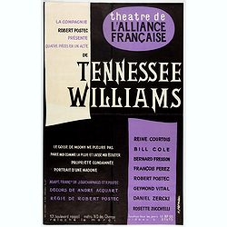
Spectacle Tennessee Williams composé de quatre pièces en 1 acte.
Theater poster for Tennessee Williams plays at the Theatre de l'Alliance Française in 1960. Poster printed in black and purple with design by K.Fernau. Playwright Tennes...
Date: Paris, Lescaret, 1960
![[Pictorial map of Georgia (Caucasus)].](/uploads/cache/44292-250x250.jpg)
[Pictorial map of Georgia (Caucasus)].
A scarce pictorial map of a region in Georgia in the Caucasus. Map is entirely in Russian, complete with legend at base of map, with small thumbnail pictures and symbols ...
- $150 / ≈ €127
Date: Moscow, 1963
![[Pictorial map of Georgia (Caucasus)].](/uploads/cache/47135-250x250.jpg)
[Pictorial map of Georgia (Caucasus)].
A scarce pictorial map of a region in Georgia in the Caucasus. Map is entirely in Russian, complete with legend at base of map, with small thumbnail pictures and symbols ...
Date: Moscow, 1963
![[In Arabic, translates : A map of the United States of America shows its major regional ressources and its natural products]](/uploads/cache/43010-250x250.jpg)
[In Arabic, translates : A map of the United States of America shows its major regional ressources and its natural products]
Chromolithographed pictorial poster of the United States in Arabic. Showing the United States' main products, regional resources and physical features. The map is covered...
Date: Washington D.C., ca. 1965
BWIA. North America - Caribbean Route Map.
An interesting double-sided brochure-type map of the routes flown by BWIA (British West Indian Airlines) between North America and the Caribbean. One side shows (not in t...
Date: USA, ca 1960-1965
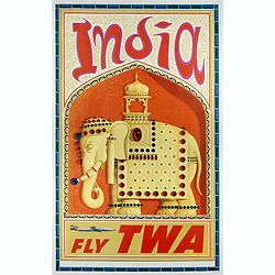
India
This India poster was created circa 1960 by David Klein (1918 -2005) for TWA. The image shows an Indian wall relief with an elephant decorated with precious stones. Eleph...
- $800 / ≈ €680
Date: 1965
U.S.S.R. Carte Physique. / U.S.S.R. Carte Population.
An unusual school map with on one side a physical map of Russia on verso a map of Russia according to population. Prepared by Pierre Serryn (1916-2002) who was professor ...
- $200 / ≈ €170
Date: St-Germain-en-Laye, 1965
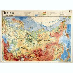
U.S.S.R. Carte Agricole. / U.S.S.R. Carte Industries et communications.
An unusual school map with on one side an agricultural map of Russia on verso a map of Russia showing communication an according to population. Prepared by Pierre Serryn ...
- $200 / ≈ €170
Date: St-Germain-en-Laye, 1965
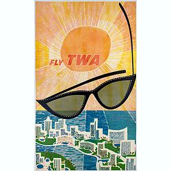
Fly TWA (Miami).
This Miami poster was created in the early 1960's by David Klein (1918 -2005) for TWA. It depicts “hotel row” along Collins Avenue leading to the corridor of South Be...
Date: 1965
![[Russian propaganda poster].](/uploads/cache/44942-250x250.jpg)
[Russian propaganda poster].
Original vintage Soviet propaganda poster for the 25th Anniversary of the Destruction of Fascist Troops in the Battle of Moscow featuring a dynamic image in shades of bla...
- $1500 / ≈ €1275
Date: Russia, 1966
![[US Army map of a part of Vietnam.]](/uploads/cache/44790-250x250.jpg)
[US Army map of a part of Vietnam.]
A large aerial US Army map of a portion of Vietnam, taken during the war between the two countries. As you might expect the map is highly detailed, highlighting settlemen...
- $150 / ≈ €127
Date: Washington D.C., 1967
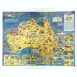
Australia, The Awakening Giant.
This large, fully colored map of Australia was published in America and Australia in the late 1960s. The map is covered in small colored illustrations, connected with loc...
Date: Victoria, 1967
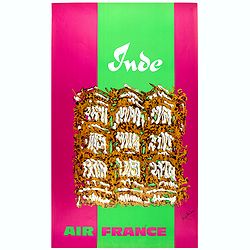
Inde.
Decorative poster advertising flights to India made by Georges Mathieu. The poster is one of a series of 15 composed of posters of Greece, Israel, Germany, Great Britain,...
Date: Paris, 1967

Japan (poster signed by Georges Mathieu)
Dedicated "Pour Benijs Boulanger" and signed "Georges Mathieu", in black marker. Decorative poster advertising flights to Japan made by Georges Mathie...
Date: Paris, 1967
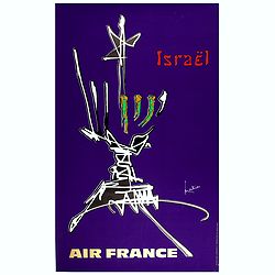
Israel.
Decorative poster advertising flights to Israel made by Georges Mathieu. The poster is one of a series of 15 posters of Greece, Israel, Germany, Great Britain, Canada, Eg...
Date: Paris, 1967
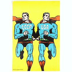
CCCP/USA, 1966
Original 1968 Cold War Superman Style Poster by Roman Cieslewicz (1930-1996). Published by Georges Fall, Paris. Printed by Serg, Paris.In 1968 the Parisian left-wing ar...
Date: Serg, Paris, 1968

Wo ai bei jing tian an men. - I Love Peking's Tie An Men. - Ich Liebe Tienanmen in Peking. - J'aime la Porte Tien an-men de Pékin.
colored Chinese Cultural Revolution poster, featuring three joyful young children looking at a drawing of a young boy on a aeroplane heading towards Tiananmen Square. The...
- $200 / ≈ €170
Date: Shaanxi renmin chubanshe, Shanhai / Beijing, ca. 1968
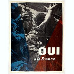
Oui à La France.
Vintage Gaullist poster against the French May 1968 events. The events of May 1968, refer to a period during which student demonstrations take place in France, as well ...
- $750 / ≈ €637
Date: Paris, 1968
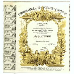
Compania General De Tabacos De Filipinas - (Certificate) Accion ordinarias de 500 Pesetas, Barcelona, 27.10.1969.
Beautifully engraved certificate from the Compania General De Tabacos De Filipinas issued in 1985. This historic document has an ornate border around it with a vignette o...
Date: Barcelona, 1969
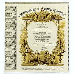
Compañia General de Tabacos de Filipinas (Certificate).
Decorative certificate with a decorative vignette and map / globe oriented to show the Philippines.Tabacalera was the popular name of Compañia General de Tabacos de Fili...
Date: Barcelone, 1969
![[Dutch provo Propaganda Poster] De Vrije Maagd Radio](/uploads/cache/898-250x250.jpg)
[Dutch provo Propaganda Poster] De Vrije Maagd Radio
Published in 1969, the year of the student unrest in Europe.Het jaar van de studenten opstanden in Europese landen! DUTCH PROVO POSTERAmsterdammers, luister niet naar ...
Date: Amsterdam, 1969
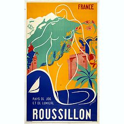
France - Roussilon - Pays de joie et de lumiere.
An original tourism poster for Roussillon, depicting a nice landscape with castle, palm tree, flower and grapes, in a beautiful color and design style. Made by the artist...
- $400 / ≈ €340
Date: Paris, ca. 1970

Sabena (USA - NYC).
Sabena Belgian World Airlines poster showing the skyline of New York in abstract style. Published by Rali Brisart in Belgium.La Sabena, acronym for Societé Anonyme Belg...
Date: Brussels, ca. 1970
![[Chinese propaganda poster]. We Shall Liberate Taiwan !](/uploads/cache/49024-250x250.jpg)
[Chinese propaganda poster]. We Shall Liberate Taiwan !
Chinese propaganda poster : "We Shall Liberate Taiwan!", by the Hongyingbi (Red Eagle Brush) unit of the Air Force Unit of Nanjing Military Region.The Chinese d...
Date: China, 1971
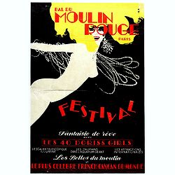
Bal du Moulin Rouge Paris - Femmes Femmes Femmes.
Poster designed by René Gruau for Bal du Moulin Rouge Paris - Festival fantaisie de rêve avec les 40 Doris Girls. Signed in the upper right-hand corner with Monogram G....
Date: Paris, Artis SA Paris, 1973
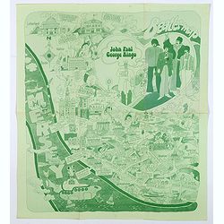
Beatles Map.
A lovely example of the scarce 'Beatles Map' of Liverpool, published in 1974 to commemorate the buildings and places where the Beatles started their stellar careers. The ...
Date: Liverpool, 1974
![[Anti capitalism Soviet Union propaganda poster]](/uploads/cache/47032-250x250.jpg)
[Anti capitalism Soviet Union propaganda poster]
Propaganda mini anti-capitalism poster published in Russia during The Cold War. By the 1960’s and 1970’s, outrageous practices in Soviet bureaucracy flourished. Poor ...
Date: Leningrad, 1974
![[Anti capitalism Soviet Union propaganda poster]](/uploads/cache/47035-250x250.jpg)
[Anti capitalism Soviet Union propaganda poster]
Propaganda mini anti-capitalism poster published in Russia during The Cold War. By the 1960’s and 1970’s, outrageous practices in Soviet bureaucracy flourished. Poor ...
Date: Leningrad, 1974
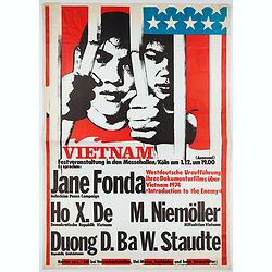
Vietnam Festveranstaltung … Jane fonda Indochine peace campaign, Ho X. De . . .
Poster for the Berlin 1974 festival organized by the Indochina Peace Campaign movement.The Indochina Peace campaign (IPC) was an antiwar organization founded in 1972 by ...
Date: Germany, 1974
![Shang dang ke (xuan zi Huxian nong min hua zhan]. (Party-lecture Education)](/uploads/cache/42021-250x250.jpg)
Shang dang ke (xuan zi Huxian nong min hua zhan]. (Party-lecture Education)
Chinese political poster in color depicting eleven peasants gathered in a room to listen to a Party supported lecture in Northwest China. The man next to the blackboard g...
- $200 / ≈ €170
Date: Shanghai renmin chubanshe, 1974/1975
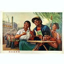
Workers - Hu Xian Peasant Painting.
Published by Shanghai renmin chubanshe (上海人民出版社). A fine Chinese propaganda poster at the tim...
Date: Shanghai, September, 1974 - variant 1975
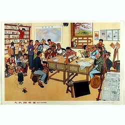
Large 13-person library (from Huxian Farmers' painting Exhibition)
A library with students with a western world map at the wall. Published by Shanghai renmin chubanshe (上海人民出...
Date: Shanghai, September, 1974 / Janury 1975
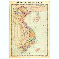
Hành Chính Việt Nam.
Uncommon map of Vietnam published in 1976, one year after the end of the Vietnam War. In April 1976, the National Assembly decided to reiterate Hanoi as the capital of th...
Date: Hanoï, 1976
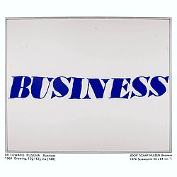
Kunst is allemaal flauwe kul.
Joop Schafthuizen is a Dutch artist known for his prints. He inspired some of the books written by his partner, the famous writer Gerard Reve. "Kunst is allemaal fla...
Date: Rotterdam, 1976
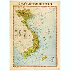
To Quoc Viet Nam Giau Va Dep (Vietnam).
Economic map of Vietnam published in 1976.Features Vietnam, Cambodia, Laos and part of Thailand. With a key referring to agricultural productions and fauna…The map show...
Date: Hanoï, 1976

The Soviet Political Poster. - a portfolio collection of 32, full-color posters.
An attractive large portfolio set of 32 reproductions published in Leningrad in 1976 by Aurora Art Publishers, containing various Soviet Union political posters from 1919...
Date: Leningrad, Aurora Art Publishers, 1976