Browse Listings
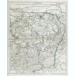
Le Brabant. Ou la Campagne du Roy de 1746. . .
Uncommon map of Dutch and Belgium Brabant by George Louis Le Rouge, who was active from 1740- till 1780 as a publisher and was appointed engineer for the King of France.D...
- $300 / ≈ €255
Date: Paris, ca. 1750
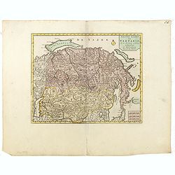
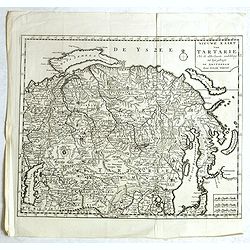
Nieuwe kaart van Tartarie.
A map of Tartary, Korea and part of Japan. The map is most notable for the confusion between Kamchatka and Iesso.There are very good details of towns and trade routes in ...
Date: Amsterdam, 1750
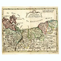
Das Hertzogthum Pommern.
Very rare map of Pomerania engraved by Johann David Schleuen (1711-1771) who was an publisher and engraver active in Berlin. He is known for his "General-Carte des g...
- $750 / ≈ €637
Date: Berlin, ca. 1750
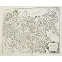
Partie Orientale de l'Empire de Russie en Asie.. et les Confins de la Tatarie Chinoise. . .
Large map with mostly topographical detail of mountains, deserts, rivers and forests. Covers the region from Tomsk eastward and includes Sakhal from his "Atlas Unive...
- $120 / ≈ €102
Date: Paris, 1750
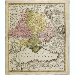
Tabula Geographica qua pars Russiae Magnae Pontus Euxinus seu mare Nigrum et Tartaria Minor cum finitimis Bulgariae, et Romaniae et Natoliae. . .
Homann's map is based upon Beauplan's general map of Ukraine but depicts the political changes of the preceding years. Shows Constantinople. Extends north to Moscow and S...
Date: Nuremburg, 1750

Typus Geographicus Chili Paraguay Freti Magellanici &c.
Detailed map covering the southern part of the continent based on the cartography of Delisle and the information gleaned from the voyages of Brouwer, Narbouroug and Beauc...
Date: Nuremberg, 1750
Partie Orientale de l'Empire de Russie en Asie.. et les Confins de la Tatarie Chinoise. . .
Large map with mostly topographical detail of mountains, deserts, rivers and forests. Covers the region from Tomsk eastward and includes Sakhal from his "Atlas Unive...
Date: Paris, 1750
Imperium Moscoviae.
Map of the empire of Moscovia
- $300 / ≈ €255
Date: Nuremberg, 1750
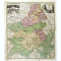
Tabula Geographica Campaniae. . .
Map of the Champagne region with Rheims, Châlons, Vitry in the center. In upper left corner two inset views with the towns of Reims et Troyes.
- $225 / ≈ €191
Date: Nuremberg, ca. 1750
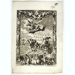
(Title page) Le Neptune François.
Title page featuring Neptune in a sea-chariot drawn by white horses, mer-people, fleets of ships and allegorical figures of winged gods, all within an ornate border. Engr...
- $550 / ≈ €467
Date: Paris, 1750

Vue de l Hotel du Lord Maire, qui comprend la Façade, et le Cot' Occidental de Londres.
Shows the famous Lord Mayor's coach driving through London. The Lord Mayor's coach is famous for its role in the Lord Mayor's Show, which is one of the longest establishe...
- $100 / ≈ €85
Date: Augsburg, 1750
Nouvelle Carte de L'Empire De La Chine et les Pais circonvoisins - Nieuwe Kaart van t Keizerryk China en de aangrensende Landen.
Finely engraved map of China and Korea, with titles in both French and Dutch.The map extends west to the Gobi Desert and Tibet and shows Macao and Canton, among other cit...
- $500 / ≈ €425
Date: Amsterdam, 1750
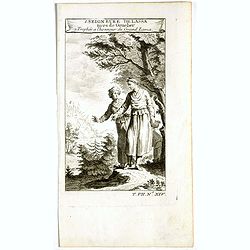
1. Seigneure Delassa tirés de Grueber. 2. Trophée à l'honneur du Grand Lama. (Tibet).
Fanciful European depiction of people from Tibet and Lhassa. A somewhat larger image appeared in "Abbe A.F. Prévost, Histoire Generale des Voyages".
Date: Paris, ca. 1750
Nouvelle Carte de L'Empire De La Chine et les Pais circonvoisins - Nieuwe Kaart van t Keizerryk China en de aangrensende Landen.
Finely engraved map of China and Korea, with titles in both French and Dutch.The map extends west to the Gobi Desert and Tibet and shows Macao and Canton, among other cit...
Date: Amsterdam, 1750
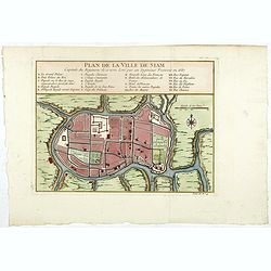
Plan de la ville de Siam.
Early plan of Siam, Thailand. Across the top is an extensive list of 22 important sites and locations keyed to the plan with tiny letters and numbers.Jacques Nicolaas Bel...
Date: Paris, 1750
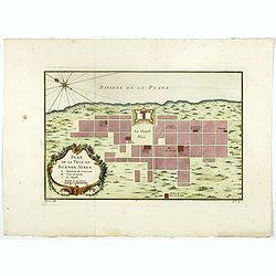
Plan de la ville de Buenos-Ayres.
Early plan of Buenos-Ayres city. Across the top is an extensive list of 22 important sites and locations keyed to the plan with tiny letters and numbers.Jacques Nicolaas ...
- $300 / ≈ €255
Date: Paris, 1750
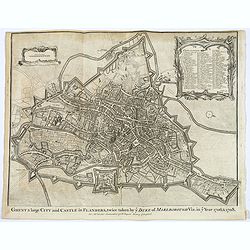
Ghent a large City and Castle in Flanders. . .
A very fine bird's-eye plan of the city and fortifications of Ghent and the surrounding countryside in Belgium. A decorative cartouche encloses a detailed key to the map ...
- $100 / ≈ €85
Date: London, ca 1750
![Plan de Mons ville capitale du comté de Haynaut. [MONS]](/uploads/cache/39799-250x250.jpg)
Plan de Mons ville capitale du comté de Haynaut. [MONS]
Charming little plan of the city of Mons in Belgium, engraved by Inselin, with a lettered key (A-V) in lower right corner.
Date: Paris, 1750
![La ville et citadelle d'Anvers. [Antwerp]](/uploads/cache/39843-250x250.jpg)
La ville et citadelle d'Anvers. [Antwerp]
A town-plan of the fortified enclosure of Antwerp with its citadel, showing the extensions made between 1201 and 1701, when the fortifications were enlarged by Philippe V...
- $225 / ≈ €191
Date: Paris, ca. 1750
![[OSTENDE] A new and exact Plan of the city and port of Ostend.](/uploads/cache/39849-250x250.jpg)
[OSTENDE] A new and exact Plan of the city and port of Ostend.
Nice plan of the city of Ostend and Fort Philippe, engraved by R. Benning. In upper left corner "A map of part of Flanders shewing the country and sands about Ostend...
- $300 / ≈ €255
Date: Paris, ca. 1750
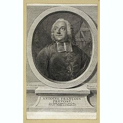
Antoine François Prevost . . .
Portrait of Antoine François Prevost (1697 – 1763), engraved by Ficquet after a design of F.Schmidt.Prevost was born at Hesdin, Artois, and first appears with the full...
- $90 / ≈ €76
Date: Paris, ca. 1750
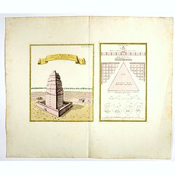
Totius Templi Beli et partis ubis Babylonicae prospectiva.
Two print on the same sheet, showing The Tower of Babe. The story of the city of Babel is recorded in Genesis 11:1–9. Everyone on earth once spoke the same language. As...
Date: Nuremberg, 1750
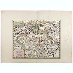
Nieuwe kaart van het Turksche Ryk gelegen in Europa, Asia en Afrika. . .
Attractive map of the Mediterranean and countries bordering, extending eastwards to include all the Arabian Peninsula.
- $700 / ≈ €595
Date: Amsterdam, 1750
Vue du serail du grand Mogol, des Indes.
Optical print of a Mogul Palace in India. Probably published by or after Jacques Chereau, who was a well-known publisher of optical prints, established in rue St. Jacques...
- $200 / ≈ €170
Date: Paris, ca. 1750
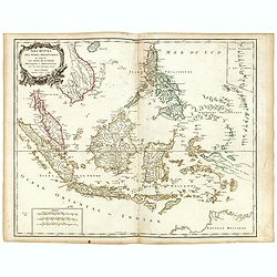
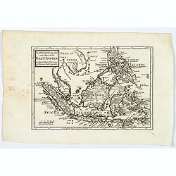
Archipel des indes Orientales
A finely engraved map depicting South East Asia with very good detail on the Philippines. Decorative title cartouche. From Atlas Universel of Gilles and Didier Robert de ...
Date: Paris, 1750
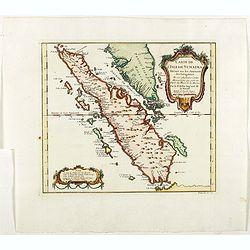
Carte de L'Isle de Sumatra Dressee sur les Journaux des Navigateurs . . .
Detailed map of Sumatra and Malacca, centered on Singapore and including the southern portion of the Malaysian peninsula. With "Detroit de Sincapour" and severa...
Date: Paris, ca. 1750
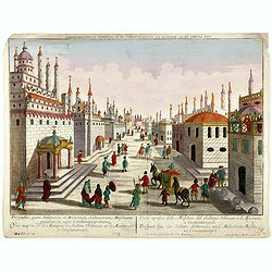
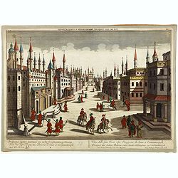
Prospectus, quem Solimanni et Mohameti. . . - Vue aupres de la Mosquee du Sultan Soliman, et de Mohamet . . .
Imaginary view inside Istanbul showing Sultan Soliman in his carriage , a so-called optical print.
Date: Augsburg 1750
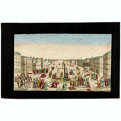
Imaginary view of a square with Muslims festival.
Imaginary view of a square with Muslims festival. A so called optical print.
Date: Paris, ca. 1750
Prospectus septem turrium in urbe Constantinopolitana / Vüe des sept Tours ou Prisons d'etat à Constantinople. . .
Imaginary view inside Istanbul showing the State prison, the seven towers to Constantinople, a so-called optical print.
Date: Augsburg 1750

Nieuwe en zeer accuraate Zee-Caart van de Hollandse Wal strekkende van de Maas tot Texel opgenomen door Jan Rokusz Douw, , ,
A very fine and rare chart of the coast of Holland, Prepared by Jan Rokusz, Douw and Agge Roskam Kool.Embellished with a very decorative cartouche with a dedicational tex...
Date: Amsterdam, 1750
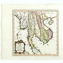
Carte des Royaumes de Siam, du Tunquin, Pegu, Ava, Aracan . . .
Map of Siam, du Tunquin, Pegu, Ava, Aracan. Across the top is an extensive list of 22 important sites and locations keyed to the plan with tiny letters and numbers.Jacque...
- $350 / ≈ €297
Date: Paris, 1750

Carte de LA LOUISIANE et des PAYS VOISINS Dédiée a M. Rouillé Dediee a M. Rouille Secretairr 'd Etat ayant le Departement de la Marine... 1750
North America from the eastern seaboard to the Rocky Mountains. Based on Delisle's map of 1718 with additions from notes compiled by the Jesuit priest, explorer and histo...
Date: Paris, 1750
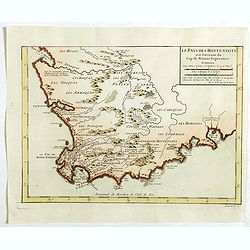
Le Pays des Hottentots . . .
Map of Good Hope Cape. Across the top is an extensive list of 22 important sites and locations keyed to the plan with tiny letters and numbers.Jacques Nicolas Bellin (170...
- $200 / ≈ €170
Date: Paris, 1750
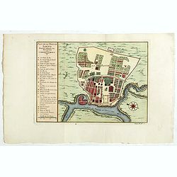
Plan de la ville de Louvo . . .
Early plan of Louvo city. Across the top is an extensive list of 22 important sites and locations keyed to the plan with tiny letters and numbers.Jacques Nicolas Bellin (...
Date: Paris, 1750
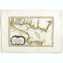
Carte de La Riviere de la Plata . . .
Map of La Plata Riviera. Across the top is an extensive list of 22 important sites and locations keyed to the plan with tiny letters and numbers.Jacques Nicolas Bellin (1...
- $350 / ≈ €297
Date: Paris, 1750
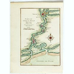
Carte du Cours du Menam . . .
Map of the Menam Riviera. Across the top is an extensive list of 22 important sites and locations keyed to the plan with tiny letters and numbers.Jacques Nicolas Bellin (...
- $200 / ≈ €170
Date: Paris, 1750
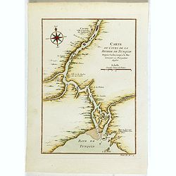
Carte du Cours de la riviere de Tunquin . . .
Map of the Tunquin Riviera. Across the top is an extensive list of 22 important sites and locations keyed to the plan with tiny letters and numbers.Jacques Nicolas Bellin...
- $200 / ≈ €170
Date: Paris, 1750

Carte de L'Isle de Sumatra Dressee sur les Journaux des Navigateurs . . .
Detailed map of Sumatra and Malacca, centered on Singapore and including the southern portion of the Malaysian peninsula. With "Detroit de Sincapour" and severa...
Date: Paris, ca. 1750
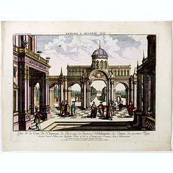
Vuë de la Cour de l'Empereur de Perse avec le diverses Habillements des Dames du premier Rang designe d'apres Nature par Quilielm Baur et fait en Estampe par François Xav. Habermann.
An optical print of the court of the Persian Emperor. Engraved by F.X. Habermann (1721-1796). The Academie Imperiale was a well-known publisher of optical prints, establi...
Date: Augsburg, 1750
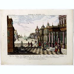
Vue du Pallais du l'Empereur de Perse avec la Mosquée, ou Eglise a Ispahan.
An optical print of the court of the Persian Emperor. Engraved by F.X. Habermann (1721-1796). The Academie Imperiale was a well-known publisher of optical prints, establi...
- $300 / ≈ €255
Date: Augsburg, 1750
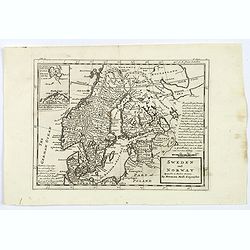
Sweden and Norway.
Herman Moll's mid eighteenth century map of Sweden and Norway, extending down to Denmark, across to Finland, and south to the Baltic states of Estonia, Livonia etc. With ...
- $125 / ≈ €106
Date: London, ca 1750
Nieuwe kaart van Tartarie. . .
A map of Tartary, Korea and part of Japan. Map place names in Korea are marked. The map is most notable for the confusion between Kamchatka and Jesso.Engraved by J.Keyser...
- $200 / ≈ €170
Date: Amsterdam, 1731 / 1750
![[Double celestial and terrestrial hemisphere]](/uploads/cache/44995-250x250.jpg)
[Double celestial and terrestrial hemisphere]
Small but uncommon double celestial and terrestrial hemisphere. The terrestrial map showing the western hemisphere with an oversized an curious Australian continent.
- $300 / ≈ €255
Date: ca. 1750
The Philippine Islands and others of the East Indies. . .
Herman Moll's 'busy' map of South East Asia and the Philippines, published in the middle of the eighteenth century in London. The map includes numerous small islands, Sum...
- $280 / ≈ €238
Date: London, ca 1750
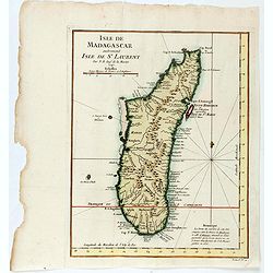
Isle de Magagascar . . .
Map of the island of Madagascar. Prepared by Jacques Nicolaas Bellin (1703-1772) who was one of the most important and proficient French cartographers of the mid-eighteen...
- $75 / ≈ €64
Date: Paris, 1750
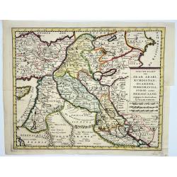
Irak, Arabi, Kurdistan, Diarbek, Turkomania, Syrie en het Heilige Land.
Isaak Tirion's map of the Near East. His 'Nieuwe en beknopte handatlas' saw 6 editions between before 1740 and after 1784. Also the 'Atlas van de Nederlandse Provintien' ...
- $350 / ≈ €297
Date: Amsterdam, ca. 1750

The East Part of India, or India beyond the R. Ganges.
Herman Moll's map of those Asian countries to be found east of the River Ganges, including Burma, Thailand, Vietnam, Laos, Cambodia, southern most China, Malaysia, Sumatr...
Date: London, ca 1750
![De Tout Cote Peur. [fear on all sides]](/uploads/cache/46782-250x250.jpg)
De Tout Cote Peur. [fear on all sides]
A lovely eighteenth-century print of an old man who has "fear on all sides." He is seen fully dressed holding a chest (of money / personal effects?) whilst clut...
- $150 / ≈ €127
Date: Paris, ca 1750

Carte particuliere des costes de Poittou, Aunis et de la Rochelle.
Finely designed and rare map of Isle Ré and the French coast with La Rochelle.
- $1250 / ≈ €1062
Date: Amsterdam, c. 1750
![[Title page Le Neptune Francois I. Volume]](/uploads/cache/47731-250x250.jpg)
[Title page Le Neptune Francois I. Volume]
Title page featuring Neptune in a sea-chariot drawn by white horses, fleets of ships and allegorical figures of winged gods, all within an ornate border. Engraved by le P...
Date: Paris, 1750
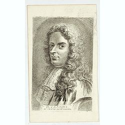
D. Cassini. Né en 1625. mort en 1712.
Very rare stipple engraved portrait of Jean Dominique Cassini. Dominique Cassini was the son of César-François Cassini de Thury, the grandson of Jacques Cassini and the...
Date: Paris, ca. 1750
![[Lot of 13 prints of the Chinese court] Habillement de l' Empereur dela Chine & des Dames de son Palais aves quel...](/uploads/cache/IMG_0845-250x250.jpg)
[Lot of 13 prints of the Chinese court] Habillement de l' Empereur dela Chine & des Dames de son Palais aves quel...
Prints of the Chinese court.[Lot of 13 prints]- Salle Imperiale De L'Audience, tiree de Nieuhof (1760)- Pagodes ou Statues; Miniso ou la Volupté (1749- Pagodes ou sta...
- $400 / ≈ €340
Date: Amsterdam, c. 1750
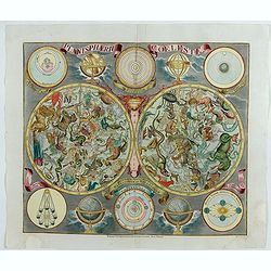
Planisphaerum coeleste.
A very decorative double hemisphere celestial chart. The 10 smaller circular diagram showing the rotation of the Planets, according to Tycho Brahe, Ptolemy and Copernicus...
Date: Nurenberg, 1750
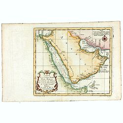
Carte de la Coste d'Arabie, Mer Rouge, et Golfe de Perse. . .
A pleasant map of the Arabian Peninsular, the Red Sea and the Gulf region, published in Paris during the mid 18th century. Published in the "Histoire generale des V...
- $200 / ≈ €170
Date: Paris, ca 1750
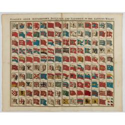
Flaggen aller seefahrenden potenzen und nationen…
A highly decorative and beautiful print with 139 flags of the sea-faring nations, factions, and trading companies. Among the more interesting flags are those of the Dutch...
Date: Nuremberg, 1750
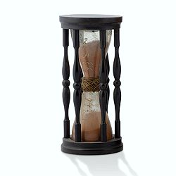
A ship's hour glass.
Maritime hourglass with blown glass bulbs, orange sand, junction ring covered with cord, the circular ebony frame with six turned baluster columns. The invention of the ...
Date: Germany, ca. 1750
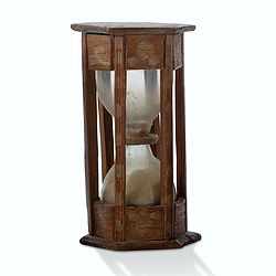
A ship's hour glass.
Maritime hourglass with blown glass bulbs, orange sand, junction ring covered with cord, the circular ebony frame with six turned baluster columns.The invention of the ho...
Date: The Netherlands, Germany, ca. 1750
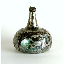
Wine bottle
The Onion-shaped wine bottle is of green glass and is sealed with cork and wax that the cork holds in place. The many years that the bottles spent under the water have l...
Date: Dutch East India Company, Netherlands, ca. 1735-1750
![[Set of 3 optical prints] Vue du Pallais du l'Empereur de Perse avec la Mosquée, ou Eglise a Ispahan.](/uploads/cache/49123-250x250.jpg)
[Set of 3 optical prints] Vue du Pallais du l'Empereur de Perse avec la Mosquée, ou Eglise a Ispahan.
An optical print of the court of the Persian Emperor. Engraved by F.X. Habermann (1721-1796). The Academie Imperiale was a well-known publisher of optical prints establis...
Date: Augsburg, 1750
Charte der Kriegs Operationen am Donn u: Dnieper Ihro Russisch Kayserl Majestaet Glorieusen Armeen A: 1736
Scarce separately published map of the southern part of Ukraine, with an explanatory key A-N in the lower right. The map is surrounded by letterpress German text giving a...
Date: Augsburg, 1750
Carte Réduite Des Costes D'Espagne Et De Portugal Depuis le Cap Pinas jusqu'au Détroit de Gibraltar..
Large-scale sea chart covering all of the coast of Portugal, with eight coastal profile insets.The chart was engraved by Herman van Loon. With rhumb lines.Published by th...
- $500 / ≈ €425
Date: Paris, 1751
La Prusse divisée en Prusse Royale et Prusse Ducale. . .
Finely and crisply engraved map of Prussia including The Bay of Danzig. Folio map by Giles Didier Robert De Vaugondy.Ornamental title cartouche in the upper part of the m...
- $350 / ≈ €297
Date: Paris, 1751

Extract uit de Resolutien door Heeren Bewindhebberen der Oost-Indische Compagnie gecommitteerd ter Vergadering van 17e binnen Amsterdam genomen op Donderdag
Contains a list of resolutions dated from 27th November 1783 and reports about the dumping of oil, tar etc. into the sea.
Date: Amsterdam, 1751
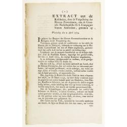
Extract uyt de Resolutien, door de Vergadering der Heeren Zeventienen, van de Generale Nederlandsche O. I. Compagnie binnen Amsterdam, genomen op Woensdag den 2 April 1774.
Contains a list of resolutions dated from 2nd April 1774 and concerning health care. Boarding crew had to be examined by the ship's surgeon. People with illnesses were to...
Date: Amsterdam, 1751

Nieuwe Wassende Graadige Pas-kaart van de Kust van Guinea en Brasilia.
Rare two-sheet sea chart of the coasts of Brazil, West Africa and South Africa, published by Johannes Van Keulen (the younger), circa 1720.The chart shows the western coa...
Date: Amsterdam, 1751
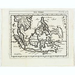
Les Indes.
Scarce small map of South East Asia with Indonesia, Thailand, Philippines and including New Guinee, based on cartography of Guillaume Delisle. Published in "Nouveau ...
- $125 / ≈ €106
Date: Paris, La veuve Lottin & Butard, P.G. Le Mercier, Rollin, 1751
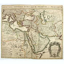
Carte de la Turquie de L'Arabie et de la Perse.
This is the Amsterdam issue of De L'Isle's map of the Turkish Empire and Arabian Peninsula. It includes the Turkish Empire, the Mediterranean, Central Asia, and parts of ...
Date: Amsterdam, 1751
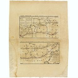
Polnische Reise Karte uber die vornehmsten Passagen von Dresden nach Warschau auf zweyerley Wegen I) uber Breslau, Peterkau und II) uber Lissa, Kaliez . . . 1751
Scarce strip-style road map showing two roads from Dresden via Glogau or Breslau to Warsaw.A key identifies villages, markets and post offices along the routes. Printed i...
Date: Nurember, 1751
![[Complete set of maps of Japan] Imperium Japonicum Per Regiones Digestum Sex et Sexaginta Atque Ipsorum Japonensium Mappis Descriptum Ab Hadriano Relando.](/uploads/cache/41590-250x250.jpg)
[Complete set of maps of Japan] Imperium Japonicum Per Regiones Digestum Sex et Sexaginta Atque Ipsorum Japonensium Mappis Descriptum Ab Hadriano Relando.
Complete set of 11 maps Reland's map of Japan, the first map to use Sino-Japanese characters on a European printed map and represents a radical departure from prior Europ...
Date: Amsterdam, 1751
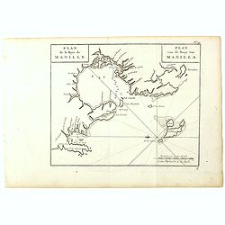
Plan de la Baye de Manille. / Plan van de Baay van Manilla.
Detailed plan of Manila Bay after George Anson's key plan of the Bay of Manila. With a compass rose and soundings in the Bay. East to the top.This is the rare Dutch editi...
Date: Amsterdam, Arkstee and Merkus, 1751
![[2 sheets] Carte particuliere de la Cote Occidentale de l'Afrique...](/uploads/cache/42917-250x250.jpg)
[2 sheets] Carte particuliere de la Cote Occidentale de l'Afrique...
A large 2 sheet map of a part of the west coast of Africa that covers The Gambia and Senegal. (When joined the map would measure approx. 1010 x 1400 mm) D'anville's maps ...
- $400 / ≈ €340
Date: Paris, ca. 1751

Vue et perspective de la ville de Marseille et ses environs, prise du côté de la belle vue de la plaine St. Michel. Dediée à S. A. S. Mgr. le duc de Penthievre Grand Amiral de France. Par son très humble et très obéissant Serviteur Aulagnier.
Scarce large and spectacular panorama of the city and harbour of Marseille published in Paris in the middle of the 18th century. Engraved by Pierre Jacques Duret under th...
Date: Paris, 1751
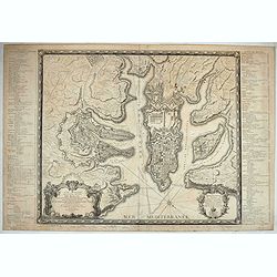
Plan général de la ville capitale de Malte dressé sur les memoires des grands officiers de l'Ordre, dédiée et présentée à S.A.S. Mgr le prince de Conty, prince du sang, grand prieur de France. . .
First edition of this attractive large scale plan of Valetta on Malta. To the left and right a numbered key 1 - 269. In lower left, a title cartouche with a dedication to...
Date: Paris, 1751

Nieuwe Wassende Graade Zee Kaart over de Spaanse Zee Vant Kanaal tot 't Eyland Cuba In Westindia.
Rare two-sheet blue-back sea chart of the Atlantic and Eastern part of North America., published by Gerard Van Keulen. The map extends from the latitude of Newfoundland a...
Date: Amsterdam, ca. 1728-1751
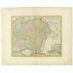
Partie Méridionale de la Russie Européenne. . .
Detailed map of Ukraine, the Crimea and the northern part of the Caspian Sea.
Date: Paris, 1752
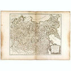
Partie Orientale de l'Empire de Russie en Asie.
Detailed map of the north-eastern part of Russia, including Siberia.
Date: Paris 1752
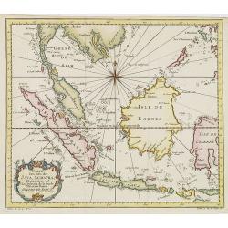
Carte Des Isles de Java, Sumatra, Borneo.. Malaca et Banca..
Jacques Nicolas Bellin (1703-1772) was one of the most important and proficient French cartographers of the mid-eighteenth century. He was appointed the first Ingenieur H...
- $300 / ≈ €255
Date: Paris, 1752
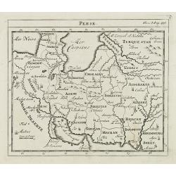
Perse.
Scarce small map of Persia based on cartography of Guillaume Delisle (. Published in "Nouveau traité de geographie par M ", published by La veuve Lottin & ...
Date: Paris, P.G. Le Mercier, 1752
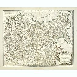
Partie Orientale de l'Empire de Russie en Asie.
Detailed map of the north-eastern part of Russia, including Siberia, Kamchatka, the island of Sakhalin.
- $200 / ≈ €170
Date: Paris, 1752