Browse Listings
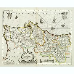
Portugallia et Algarbia quae olim Lusitania. . .
Rare map of Portugal with decorative title cartouche. Oriented to the west. Prepared by Fernando Alvares Seco.
Date: Paris, c.1630
![[Title page] Thesauri Philo Politici pars Prima ...](/uploads/cache/38450-250x250.jpg)
[Title page] Thesauri Philo Politici pars Prima ...
Very skillfully engraved title page from a rare work printed by Eberhard Kieser: "Thesaurus Philo-Politicus. Das ist Politisches Schatzkästlein guter Herren und bes...
- $80 / ≈ €68
Date: Frankfurt, 1630
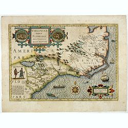
Virginiae item et Floridae. . .
Cummings describes it as one of the most beautifully executed maps ever made of the Southeast. In detail and in general conception it surpasses all earlier maps of the re...
- $2200 / ≈ €1870
Date: Amsterdam, 1630
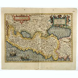
Terra Sancta que in Sacris Terra Promissionis ol: Palestina
This map of Palestine extending from the Lebanon mountains to the Dead Sea is based on the large map by P.Laicksteen and Chr.'s-Grooten in the latter part of the sixteent...
- $900 / ≈ €765
Date: Amsterdam, 1630
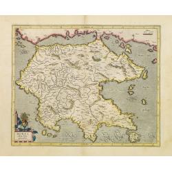
Morea olim Peloponnesus.
Gerard Mercator's map of the Greece's Peloponnesus peninsula called and labeled Morea. A few of the other smaller islands appear included the larger Cerigo (today's Cythe...
- $300 / ≈ €255
Date: Amsterdam, 1630

Zelandia Comitatus.
Based on the map by Van Deventer. For the first time a road connection between Flushing, Middelburg and Arnemuiden is shown. Mercator pays much attention to the area of s...
Date: Amsterdam, 1630
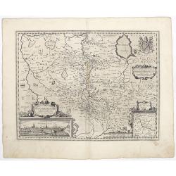
![Tabula electoratus Brandenburgici, Meckelenburgi, et maximae partis Pomeraniae, ex variis, famosissimisq[ue] auctoribus summo studio concinnata. . .](/uploads/cache/29543-250x250.jpg)
Tabula electoratus Brandenburgici, Meckelenburgi, et maximae partis Pomeraniae, ex variis, famosissimisq[ue] auctoribus summo studio concinnata. . .
Uncommon "carte à figures"- map engraved by the master engraver Abraham Goos and published by Claes Jansz. Visscher (1587-1652). Showing the area of Brandenbur...
Date: Amsterdam, 1630
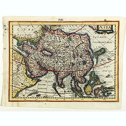
Asia.
Asia map from the rare Cloppenburg edition slightly larger format and more scarce edition of the Mercator/Hondius "Atlas Minor". Engraved by Pieter Van Den Keer...
Date: Amsterdam, 1630
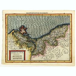
Pomeraniae Ducatus.
Pomerania map from the rare Cloppenburg edition slightly larger format and more scarce edition of the Mercator/Hondius "Atlas Minor". Small and detailed map of ...
Date: Amsterdam, 1630
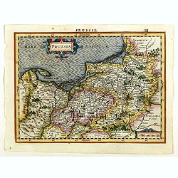
Prussia.
An attractive, detailed and early map of present-day Poland and Lithuania from the rare Cloppenburg edition slightly larger format and more scarce edition of the Mercator...
Date: Amsterdam, 1630
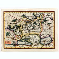
Russia.
Russia map from the rare Cloppenburg edition slightly larger format and more scarce edition of the Mercator/Hondius "Atlas Minor". Engraved by Pieter Van Den Ke...
Date: Amsterdam, 1630
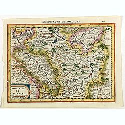
Polonia et Silesia.
Map of Poland and Silesia from the rare Cloppenburg edition slightly larger format and more scarce edition of the Mercator/Hondius "Atlas Minor". Engraved by Pi...
Date: Amsterdam, 1630
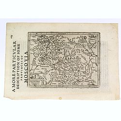
A More Particular Description of some Provinces of Moscovia.
From the English edition of the popular Mercator - Hondius atlas. English text to verso. This map elegantly depicts the Muscovy region of western Russia, with Moscow in t...
- $225 / ≈ €191
Date: Amsterdam, 1630
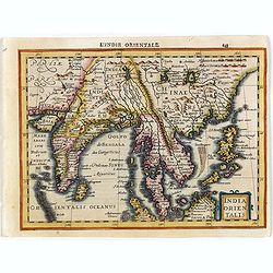
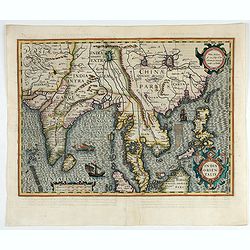
India Orientalis.
Map covering India, Thailand, Philippines, Northern Borneo and the coast of Southern China. From the rare Cloppenburg edition "Atlas Sive Cosmographicae Meditationes...
- $550 / ≈ €467
Date: Amsterdam, 1630
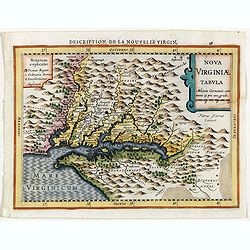
Virginiae item et Floridae . . .
Map of Virginia from the rare Cloppenburg edition slightly larger format and more scarce edition of the Mercator/Hondius "Atlas Minor". Engraved by Pieter Van D...
- $750 / ≈ €637
Date: Amsterdam, 1630
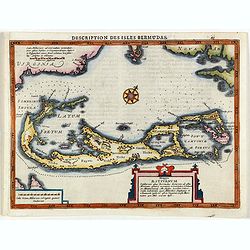
Description des Isles Bermudas.
Map of Bermuda from the rare Cloppenburg edition slightly larger format and more scarce edition of the Mercator/Hondius "Atlas Minor". Engraved by Pieter Van De...
- $800 / ≈ €680
Date: Amsterdam, 1630
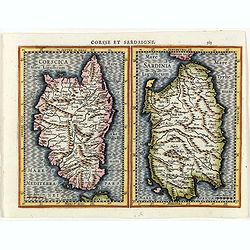
Corsse et Sardaigne.
Maps of Corsica and Sardinia from the rare Cloppenburg edition slightly larger format and more scarce edition of the Mercator/Hondius "Atlas Minor". Engraved by...
- $300 / ≈ €255
Date: Amsterdam, 1630

Irlandiae Regnum.
A very nice map from Ireland.Mercator was born in Rupelmonde in Flanders and studied in Louvain under Gemma Frisius, Dutch writer, astronomer and mathematician. The excel...
Date: Amsterdam, 1630
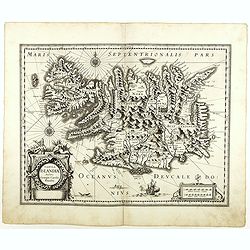
Tabula Islandiae. . .
With a very decorative cartouche, and a very fine imprint. No text on verso; included in the rare "Appendix" of 1630. VERY RARE. This handsome map of Iceland wa...
- $1200 / ≈ €1020
Date: Amsterdam, 1630
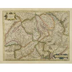
Helvetia cum finitimis regionibus confoederatis.
Detailed and finely engraved map of Switzerland.
- $350 / ≈ €297
Date: Amsterdam, 1630
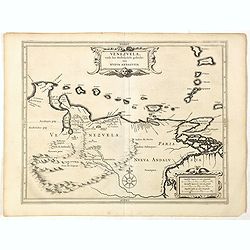
Venezuela, atque Occidentalis Pars Novæ Andalusiae.
Coastline of Venezuela with little interior development. Including Aruba, Bonaire, Curaçao, etc. Scarce map prepared by Hessel Gerritsz (1581-1632), former apprentice of...
- $600 / ≈ €510
Date: Leiden, Elzevier, 1630
![[Title page] Thesauri Philo-Politci Pars Sexta. . .](/uploads/cache/38446-250x250.jpg)
[Title page] Thesauri Philo-Politci Pars Sexta. . .
Very skilfully engraved title page from a rare work printed by Eberhard Kieser: Thesaurus Philo-Politicus. Das ist Politisches Schatzkästlein guter Herren und bestendige...
- $60 / ≈ €51
Date: Frankfurt, 1630
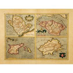
Anglesey. / Iarsay. / Carnesay. / Wight Vectis Olim.
Four maps on one sheet depicting the English islands Jersey, Guernsey, Wright and Alderney.
Date: Amsterdam, 1630
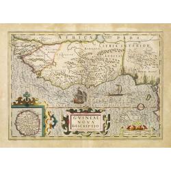
Guineae Nova Descriptio.
The map shows the West African coast from Senegal (the 'Rio Senega' is the Senegal River) to Cape Lopez on the Gulf of Guinea just below the equator. The island of St. Th...
- $450 / ≈ €382
Date: Amsterdam, 1630
![[Title page for] : Atlas Minor ou Briefve, & vive description de tout le Monde. . .".](/uploads/cache/47932-250x250.jpg)
[Title page for] : Atlas Minor ou Briefve, & vive description de tout le Monde. . .".
Title page from a French 1630 edition of Atlas Minor (352:11). Engraved title page, pasted-on title and imprint (over the original Latin title and imprint 1628). Read mor...
- $250 / ≈ €212
Date: Amsterdam, 1630
![[Title page] Thesauri Philo Polithi Tertia pars..](/uploads/cache/38445-250x250.jpg)
[Title page] Thesauri Philo Polithi Tertia pars..
Very skilfully engraved title page from a rare work printed by Eberhard Kieser: "Thesaurus Philo-Politicus. Das ist Politisches Schatzkästlein guter Herren und best...
- $80 / ≈ €68
Date: Frankfurt, 1630
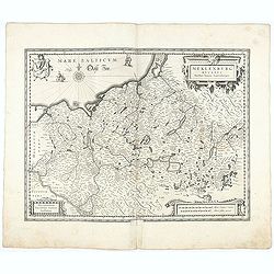
Meklenburg Ducatus.
Very detailed map of the northern part of Germany decorated with a coat of arms, a windrose and two saling ships.From the rare atlas Appendix, published in a very small n...
Date: Amsterdam, 1629-1630
India Orientalis.
Published in Hondius' editions of the Mercator Atlas from 1606 onwards, showing the Indian subcontinent, the Malay Peninsula, Siam and Cambodia, China and the Philippines...
- $2000 / ≈ €1700
Date: Amsterdam, 1630
Ducatus Luneburgensis
Very detailed map centered on Albis river and the cities of Hamburg and Lunburg to the north. Also showing Bremen.
Date: Amsterdam, 1629-1630
Palatinatus Rheni.
Map depicting part of Germany provinces.
Date: Amsterdam, 1630

Comitatus Flandria.
First published by the van Langrens c.1595, after his acquisition of the plate, Visscher heavily re-engraved the map, inserting panelled borders on three sides (the lower...
Date: Amsterdam, c. 1630
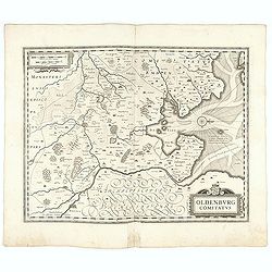
Oldenburg Comitatus
A map of the northern part of Germany centered on Oldenburg. Also showing Bremen. North to the right. The decoration consists with a windrose and a title cartouche surmou...
Date: Amsterdam, 1629-1630
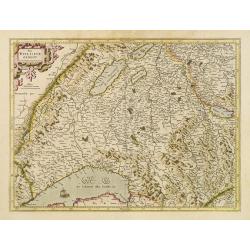
Das Wiflispurgergov.
In lower right Geneva and Lake Geneva with Lausanne. In center of map the cantons of Fribourg and Bern.
- $350 / ≈ €297
Date: Amsterdam 1630
![[Title page] Thesauri Philo Politici pars Tertia ...](/uploads/cache/38449-250x250.jpg)
[Title page] Thesauri Philo Politici pars Tertia ...
Very skillfully engraved title page from a rare work printed by Eberhard Kieser: "Thesaurus Philo-Politicus. Das ist Politisches Schatzkästlein guter Herren und bes...
Date: Frankfurt, 1630
![Hanc Tabulam continens Laetam Pharnambuci.. . [Brazil].](/uploads/cache/16521-250x250.jpg)
Hanc Tabulam continens Laetam Pharnambuci.. . [Brazil].
An extremely rare and decorative map of coast-line of Pernambuco. With one inset: In the upper left corner a map of Brazil, with title in five lines Dutch and five lines ...
Date: Amsterdam, 1630

Nova Helvetiae Tabula.
A most decorative "carte à figures" map with panoramic views of Lucern, S.Gal, Bern, Solothurn, Schafhausen in upper border and Basel and Zurich in lower left ...
Date: Amsterdam, 1630
![[Title Page] Atlas Sive cosmographicae Meditationes . . .](/uploads/cache/39451-250x250.jpg)
[Title Page] Atlas Sive cosmographicae Meditationes . . .
Title page from the rare Cloppenburg edition slightly larger format and more scarce edition of the Mercator/Hondius "Atlas Minor". Engraved by Pieter Van Den Ke...
Date: Amsterdam, 1630
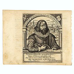
Henricus Kornmannus I.U. Doc. ex Kyrchayna cat.
Very skillfully engraved half-length portrait of Heinrich Kornmann, in frontal view, underneath an arch and with a view of Kirchhain in background and coats-of-arms in up...
Date: Frankfurt, 1630
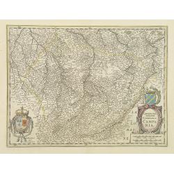
Champagne Comitatus Campania.
Map of French region of Champagne, including part of Lorraine. North to the east. The second state with the signature of J.Janssonius.
- $220 / ≈ €187
Date: Amsterdam, 1630
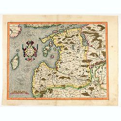
Livonia. 1627
Detailed map of the northern Baltic region. The map is centered on Riga and extends south to Memel, west to Poland and part of Russia and north to the Strait between Finl...
Date: Amsterdam, ca. 1630
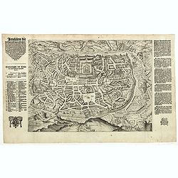
Jerusalem die vernaamste van alle steden... / Jerusalem die Heijlighe Stadt van God. . .
Very rare separately published plan of Jerusalem, engraved by Joannes van Doetecum Jr., Variant to Poortman, Kaarten in Bijbels, map 64. In the lower part, the copper pla...
Date: Amsterdam, 1598-1630
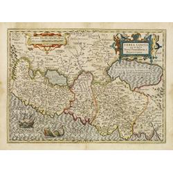
Terra Sancta que in Sacris Terra Promissionis ol: Palestina.
This map of Palestine extending from the Lebanon mountains to the Dead Sea is based on the large map by P.Laicksteen and Chr.'s-Grooten in the latter part of the sixteent...
Date: Amsterdam, 1630
Westphalia Ducatus.
Elegantly engraved map of Westphalia including Hamm and Lippstadt. The mountainous topography is graphically depicted and several small coats of arms dot the map. Strapwo...
Date: Amsterdam, 1629-1630
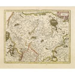
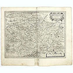
Episcopatus Paderbornensis
Detailed map centered on Paderborn. Prepared by Joannes Michael Gigas (1580-1650+), a doctor, mathematician and geographer who made also maps of Osnabrug, Westphalia, Mun...
Date: Amsterdam, 1629-1630

Tabula nova Poloniae et Silesiae.
Second state, dated 1630 underneath the title. A finely engraved carte á figures with cartouche representing in the four corners of the map : Kings ( on the left side Si...
Date: Amsterdam, 1630
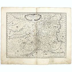
Osnabrugensis episcopatus. . .
A beautiful map of Munster centered on the city of Osnabruck. Prepared by Joannes Michael Gigas (1580-1650+), a doctor, mathematician and geographer. Showing an inset wit...
Date: Amsterdam, 1629-1630
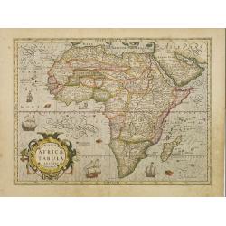
Nova Africae Tabula.
An attractive map of the continent, added by Hondius when he took over publication of Mercator's Atlas. Although it is based on Mercator's map, Hondius improved the outli...
Date: Amsterdam, 1630
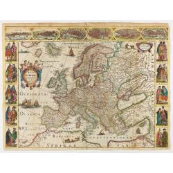
Nova Europae descriptio.
Rare early issue of the map of Europe with the lower border removed and without text on the reverse. Variant : The map has no longer the lower border, doesn't have text o...
Date: Amsterdam, after 1630
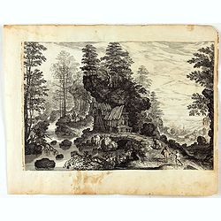
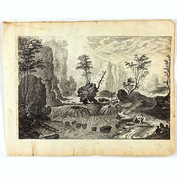
Blick auf eine Waldlandschaft mit reisenden Männern und einem Dorf in der Ferne.
Etching by Isaak Major and published by Jeremias Wolff depecting a view of a forest landscape with men traveling and a village in the distance. Large print edited by Jere...
- $200 / ≈ €170
Date: Augsburg, 1600-1630

Daniae regni typum . . .
Second Edition, now for the first time with a date (1630), this rare map which - like that of Janssonius-Kaerius - is based on John Speed's map of 1626. The side borders ...
Date: Amsterdam, 1630

Candia cum Insulis.. Corfu Zante, Milo, Nicsia, Santorini.
Four views on one sheet: A large map of Crete, with three smaller views across the top showing the Ionian Islands of Kerkira (Corfu), Cephalonia and Zakinthos (Zante.) Th...
Date: Amsterdam, 1630
Landschaft mit Wasserfall und Schublade.
Etching by Isaak Major and published by Jeremias Wolff depecting a wide landscape with mountains ,rocks and a waterfall. Several people among withc a drawer at right. Lar...
- $150 / ≈ €127
Date: Augsburg, 1600-1630
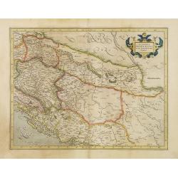
Sclavonia, Croatia, Bosnia cum Dalmatiae parte.
Nice map of the Eastern Balkans with the political divisions of Slovenia, Croatia, Bosnia and Dalmatia.Mercator was born in Rupelmonde in Flanders and studied in Louvain ...
- $300 / ≈ €255
Date: Amsterdam 1630
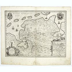
Typus Frisiae Orientalis.
Decorative map of east Frisia in Germany with the Watten islands. With inset map of the area south of Emden. Prepared by Ubbo Emmius (1547-1625). Two very decorative coat...
Date: Amsterdam, 1629-1630
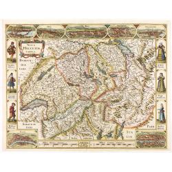
Nova Helvetiae Tabula.
A most decorative "carte à figures" map with panoramic views of Lucern, S.Gal, Bern, Solothurn, Schafhausen in upper border and Basel and Zurich in lower left ...
Date: Amsterdam, 1630
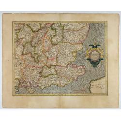
Warwicum Northamtonia Huntingdonia Cantabrigia..
Showing the south-eastern part of England.
Date: Amsterdam, 1630
![[Portrait of Gerard Mercator and Jodocus Hondius.]](/uploads/cache/49107-250x250.jpg)
[Portrait of Gerard Mercator and Jodocus Hondius.]
Arguably the finest engraved portrait of early mapmakers. In the well-executed design, Gerard Mercator and Jodocus Hondius are seated within an architectural cartouche of...
Date: Amsterdam, 1630
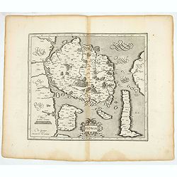
Fionia.
Early map, including Odense and the island Langeland .
- $200 / ≈ €170
Date: Amsterdam, 1630

India Orientalis.
Published in Hondius' editions of the Mercator Atlas from 1606 onwards, showing the Indian subcontinent, the Malay Peninsula, Siam and Cambodia, China and the Philippines...
Date: Amsterdam, 1630
![[Titlepage] Germaniae tabule geographicae.](/uploads/cache/12197-250x250.jpg)
[Titlepage] Germaniae tabule geographicae.
Decorative title page to the volume of the "Atlas, Sive Cosmographicae Meditationes De Fabrica Mundi" devoted to maps of Germany. The design in a typical Manner...
- $280 / ≈ €238
Date: Amsterdam, 1630
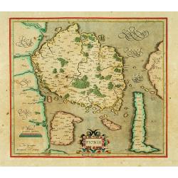
Fionia.
Early map, including Odense and the island Langeland .
- $200 / ≈ €170
Date: Amsterdam 1630
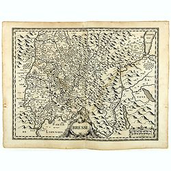
Bresse.
Early map of Eastern France with Lyon to the lower left corner and part of Switzerland. Geneva in upper right corner. Engraved by Hondius. From a French composite atlas.R...
- $150 / ≈ €127
Date: Amsterdam, 1631

Zeelandiae Comitatus.
Rare map of Zeeland, with inset view of the town of Middelburg topped with costumed figures. This is the second edition published by Claes Jansz. Visscher. The first edit...
Date: Amsterdam, 1617-1631

Belgii sive Germaniae Inferioris accuratissima tabula.
Very rare and very decorative map with in the right and left borders costumed figures and town plans alternately. In top and bottom border town plans and views.Separate p...
Date: Amsterdam, 1631

Belgium sive Inferior Germania post omnes..
Early map of the Low Countries, engraved by Abraham Goos and published for the first time in 1618. In the top border town-views of Amsterdam, Dordrecht, Antwerp, Brussels...
Date: Amsterdam, 1618/1631
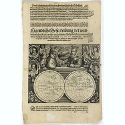
Description de nouveau pasage vers le zud.... together with an untitled map of Port Desire (today's Puerto Deseado, Argentina)
Rare double hemispherical world map showing the track round the world by Le Maire and Schouten in 1615-1617. Continents are marked in outline and no southern regions are ...
- $1500 / ≈ €1275
Date: Frankfurt, M.Merian, 1631
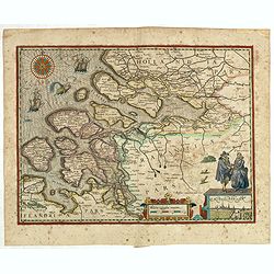
(Zeeland)
Rare map of Zeeland, first issued by Petrus Kaerius, than by Claes Jansz. Visscher. The copper plate was previously made by an anonymous engraver, and than came into the ...
- $1050 / ≈ €892
Date: Amsterdam, 1631
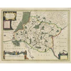
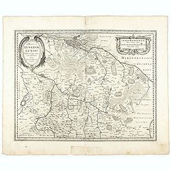
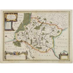
Description du Gouvernement de la CAPPELLE. Par P. Petit Bourbon.
RARE without text on verso. Decorative map of Cappellein the region of the Nord-Pas-de-Calais in France with three decorative cartouches.The map of Cappelle is by Pierre ...
- $150 / ≈ €127
Date: Amsterdam, 1631
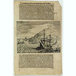
Cocos Insel Cocos Insula / Verräter Insel Insula proditorum.
Scarce print (148x204mm.) on a German text sheet showing the landing of Le Maire and Schouten at Cocos Island in May 1616 (today’s Tafahi in the Tonga Islands). Named b...
- $150 / ≈ €127
Date: Frankfurt, M.Merian, 1631
![[The attack by Schouten and his men on a waka.]](/uploads/cache/39754-250x250.jpg)
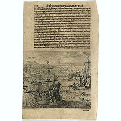
[The attack by Schouten and his men on a waka.]
Scarce print (145x210mm.) on a German text sheet showing the attack by Schouten and his men on a waka.The page is taken from a first edition of Johann Ludwig Gottfried's ...
- $150 / ≈ €127
Date: Frankfurt, M.Merian, 1631
Description du Gouvernement de la CAPPELLE. Par P. Petit Bourbon.
Decorative map of Cappellein the region of the Nord-Pas-de-Calais in France with three decorative cartouches.The map of Cappelle is by Pierre Petit Bourbon (1598-1667), m...
- $100 / ≈ €85
Date: Amsterdam, 1631
Vligen Insel.
Scarce print (168x200mm.) on a German text sheet showing the attack of mosquitos on Schouten's ship.The page is taken from a first edition of Johann Ludwig Gottfried's &q...
- $75 / ≈ €64
Date: Frankfurt, M. Merian, 1631
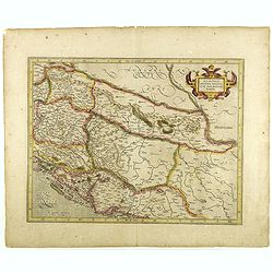
Sclavonia, Croatia, Bosnia cum Dalmatiae parte.
Nice map of the Eastern Balkans with the geographical & political divisions of Dalmatia, Croatia, Slavonia, Bosnia, Serbia, etc.Mercator was born in Rupelmonde in Fla...
- $250 / ≈ €212
Date: Amsterdam, 1632

Nova Germaniae Descriptio..
A finely engraved carte à figures, with the side borders depicting emperors, while the upper and lower panels contain finely engraved miniature town prospects, among the...
Date: Amsterdam, 1632
Pere Grinatie. De Reijse der Kinderen Israels so zij wt Egip . . .
Scarce separately engraved map of the Holy Land by Joannes van Doetecum Jr.In the lower right corner, inset with a title cartouche surrounded by Aaron, the encampment of ...
Date: Amsterdam, 1598, The Hague, 1632
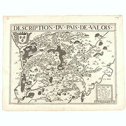
Description du pais de Valois.
Rare map published by Jean Le Clerc (1560-1621) and prepared by Damien de Templeux map of the region to the northeast of Paris, between the Oise River in the west and the...
- $300 / ≈ €255
Date: Paris, 1632

Episcop. Ultraiectinus.
A very detailed map based on Utrecht. Scale cartouche held by a surveyor. Based on the map by B.F.van Berckenrode (1620-21) and engraved by the master engraver Evert Sijm...
Date: Amsterdam, 1630-1632
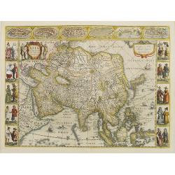
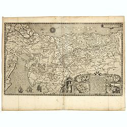
Asia recens summa cura delineata.
This is the rare early issue with decorative paneled borders. In upper border views and plans of Famagusta, Rhodos, Damascus, Jerusalem, Aden and Ormus. Originally engrav...
Date: Amsterdam, 1632
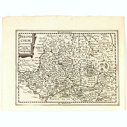
Belovacium comitatus.
Early map centered north of Paris. With Latin text on verso. Engraved by Petrus Kaerius. Shortly after the publication of big folio-atlases the need was apparently felt f...
- $75 / ≈ €64
Date: Amsterdam, 1632
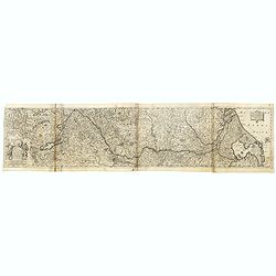
Totius Rheni, ab eius Capitibus ad Oceanu usque Germanicum in quem se Exonerat Novissima Descriptio.
The course of the Rhine river by Henricus Hondius. Originally engraved as two parts on one sheet. Here separated and joined to one large map. The map is showing the compl...
- $300 / ≈ €255
Date: Amsterdam, ca. 1632