Search Listings matching "santini"
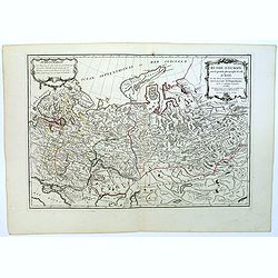
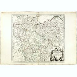
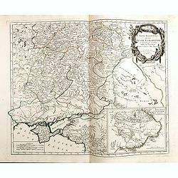
Carte de la Lithuanie Prussienne qui comprend les Palatinats de Livonie, de Witepsk, de Liscislaw, et une partie de ceux de Polock et de Minsk cédés par la Pologne à la Russie. Dressée sur l'Exemplaire des Héritiers Homann 1775.
Detailed map of the areas along the river Dnieper and Duna. Santini gives credit to Homann Heirs in the cartouche.The map was prepared by the Venetian cartographer and pu...
Date: Venice, 1776

Etats du Grand-Seigneur en Asie, empire de Perse, pays des Usbecs, Arabie et Egypte.
Detailed map of the region bounded by the Black Sea, Georgia, the Caspian, Uzbekistan, The Indian Ocean, Saudi Arabia (here called \"Arabie Heureuse\"), Egypt a...
Date: Venise, 1778
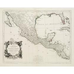
Carte du Mexique et de la Nouvelle Espagne..
Santini's version of D'Anville's important map shows the south-eastern part of the United States, Mexico and the Gulf of Mexico. Tecas is named as Nouv'le Leon. La Salle'...
Date: Venice 1779
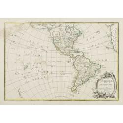
L' Amerique divisée par Grands Etats. . .
Attractive map of America, ornated with a decorative title cartouche. Boundaries outlined in hand color.Prepared by Le Sieur Janvier, Jean denis [Robert], French geograph...
Date: Paris, ca 1783
Russie d'Europe avec la partie la plus peuple de celle d'Asie...
A detailed map covering what was 'Russia in Europe', toward the end of the eighteenth century. Decorated with a decorative title cartouche, and an 'Advertisement'.Boundar...
- $150 / ≈ €132
Date: Paris, ca 1783
Cercle de Basse Saxe où sont distingués les états de ... et des évêchés d'Hildesheim et d'Halberstadt par le Sr. Robert.
Finely and crisply engraved map of northern part of Germany, including the river Elbe, with Hamburg until Potsdam. In the upper right the Baltic coast including Wismar, R...
Date: Venice, 1776 - 1784
Carte des Cercle du Haut et du Bas Rhin.. avec leurs enclaves.
Finely and crisply engraved map of Germany showing the river Rhine, including Duisburg, Spire, Mannheim, etc.With ornamental title cartouche and noteworthy topographical ...
Date: Venice, 1776 - 1784
Cercle de Haute Saxe.
Finely and crisply engraved map of Germany, centered on Leipzig. From Atlas Universel printed in 1776-84.With ornamental title cartouche and noteworthy topographical deta...
Date: Venice, 1776 - 1784
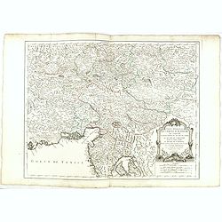
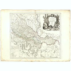
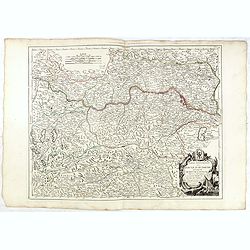
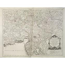
Partie Meridionale du Cercle d'Autriche qui comprend La basse partie du Duché de Strie, Le Duché de Carinthie, divisé en haute et basse, Le Duché de Carniole. . . Et l'Istrie Impériale. . .
Uncommon, finely and crisply engraved map with large decorative title cartouche.Very detailed sheet that is centered roughly on Trieste and extends in to the mouth of the...
Date: Venice, 1784
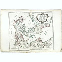
Royaume de Danemarck. qui comprend le Nort-Jutland . . . Sélande, Laland.
Finely and crisply engraved map of Denmark. Venetian edition of Giles Didier Robert De Vaugondy's map from Atlas Universel printed in 1776-84. Ornamental title cartouche ...
Date: Venice, 1776 - 1784
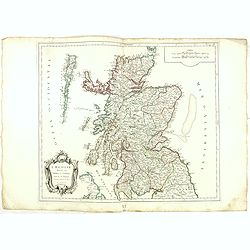
L'Ecosse divisée en Shires et Comtés.
Finely and crisply engraved map of Scotland.Venetian edition of Giles Didier Robert De Vaugondy's map from Atlas Universel printed in 1776-84.Ornamental title cartouche i...
Date: Venice, 1776 - 1784
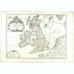
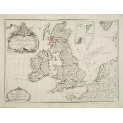
Les Isles Britanniques Comprenant les Royaumes D'Angleterre, D'Ecosse et D'Irlande divisée en grands provinces. . .
Detailed map encompassing present day British Isles. An inset in the upper right details the Shetland and Orkney Islands. Venetian edition of the map by Janvier, to whom ...
Date: Venice, 1776 - 1784

Carte de la Pologne Autrichienne contenant La Russie Rouge et la partie méridionale du Palatinat de Cracovie . . .
Detailed map with Krakow, including the areas of Malopolskie and Podkarpackie and including present-day Ukraine.Santini gives credit to Homann Heirs in the cartouche. Mal...
Date: Venise 1776-1784
Partie Méridionale de la Russie Europeenne ou sont distinguees exactement toutes les Provinces, d'après le detail de l'Atlas Russien.
Detailed map of southern European Russia, including Yugoslavia. The map was first published by the Venetian cartographer and publisher François (Père) Santini and first p...
Date: Venice, 1784
Royaume d'Esclavonie et du Duché De Syrmie..
Detailed map encompassing show us Danube and to the right Belgrade.From "Atlas Universel" published by Santini in 1776-84. The atlas is effectively an Italian c...
Date: Venice, 1776 - 1784
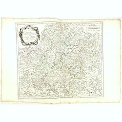
Cercle de Franconie.. Reineck d' Erpach.
Finely and crisply engraved map, centered on Schweinfurt, Bamberg and Nuremberg.With ornamental title cartouche and noteworthy topographical detail.The map was prepared b...
Date: Venice, 1776 - 1784
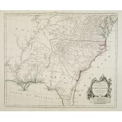
Partie Méridionale de la Louisiane, avec la Floride, la Caroline et la Virginie..
Fine map of southeastern part of the United States after d'Anville's, to whom Santini gives credit in the cartouche.It covers the Atlantic coastline between the Chesapeak...
Date: Venice, 1776 - 1784
Cercle de Westphalie divisé en tous ses Etats et Souverainetés.
Finely and crisply engraved map of central Germany, including the river Rhine from Deventer till Bonn, with Dusseldorf. In upper left , inset of the area of Emden until O...
Date: Venice, 1776 - 1784
Partie meridionale des Pays Bas.. Cambrefis et Artois.
Finely and crisply engraved map of Belgium, including southern part of Netherlands and part of Germany.Venetian edition of Giles Didier Robert De Vaugondy's map from Atla...
Date: Venice, 1776 - 1784
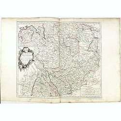
Partie Septentrionnale du Cercle d'Autriche.. Duché de Stirje.
Finely and crisply engraved map of Austria, centered on Vienna.Venetian edition of Giles Didier Robert De Vaugondy's map from Atlas Universel printed in 1776-84.With orna...
Date: Venice, 1776 - 1784
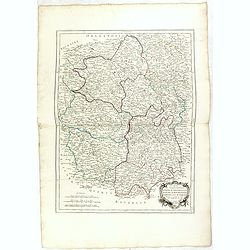
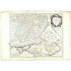
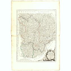
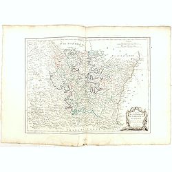
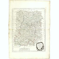
Gouvernements de Berri, du Nivernois,de la Marche, Limousin..
Detailed map encompassing Berri, Nivernois, Limousin and Auvergne.Venetian edition of the map by Bonne, to whom Santini gives credit in the cartouche.From "Atlas Uni...
Date: Venice, 1776 - 1784
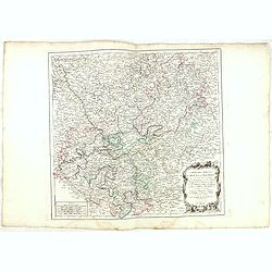
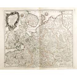
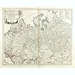
Partie Septentrionale de la Russie Europeenne ou sont distinguees exactement toutes les Provinces, d'apres le detail de l'Atlas Russien, Par le Sr. Robert de Vaugondy fils, Geog. Ordin? Du Roi.
Detailed map of northern European Russia, including Finland. The map was first published by the Venetian cartographer and publisher François (Père) Santini and first publ...
Date: Venice, 1784
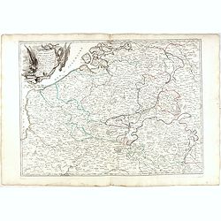
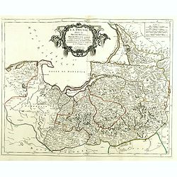
La Prusse divisée en Prusse Royale et Prusse Ducale.
The map extends from Memem, Danzig and Rosienne in the North to Novigrod in the southeast and Thorn on the Wessel in the southwest. Shows the Gulf of Danzig and part of P...
Date: Venice, 1776 - 1784
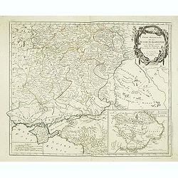
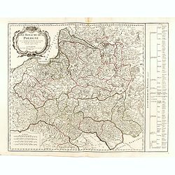
Royaume de Pologne.
Detailed map encompassing present-day Poland. The table provides a breakdown of the sub-regions of the Polish Crown.Venetian edition of the map by R. de Vaugondy, to whom...
- $350 / ≈ €308
Date: Venice, 1776 - 1784
Gouvernements de Bourgogne, de Franche Comté et de Lyonnois.
Detailed map encompassing Bourgogne, Franche Comté and Lyonnois.Venetian edition of the map by Bonne, to whom Santini gives credit in the cartouche.From "Atlas Unive...
Date: Venice, 1776 - 1784

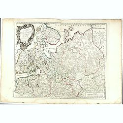
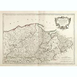
Carte De La Prusse Occidentale ou sont tracees les Provinces cedees Par la Pologne au Roi De Prusse . . . 1775
Finely and crisply engraved map of Western Prussia, now part of Poland on the Baltic Sea, including the Bay of Danzig. With ornamental title cartouche and noteworthy topo...
Date: Venice, 1776 - 1784
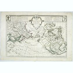
Carte des nouvelles decouvertes au Nord de la Mer du Sud.
Although concentrating on the northern Pacific, this map shows all of North America and Mexico.While the Russian coastline is shown with reasonable accuracy, notwithstand...
- $1800 / ≈ €1582
Date: Venice, 1776 - 1784
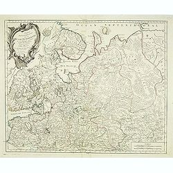
Partie Septentrionale de la Russie Europeenne ou sont distinguees exactement toutes les Provinces, d'apres le detail de l'Atlas Russien, Par le Sr. Robert de Vaugondy fils, Geog. Ordin? Du Roi.
Detailed map of northern European Russia, including Finland. The map was first published by the Venetian cartographer and publisher François (Père) Santini and first publ...
Date: Venice, 1784

Carte Générale du Canada, de la Louisiane, de la Floride, de la Caroline..
Map of the eastern part of the United States and Canada. With inset map of Hudson and Baffin bays. in the lower right corner.Venetian edition of d'Anville's map, from &qu...
Date: Venice, 1776 - 1784

Nouvelle Mappa Monde.
State 2 of this fine double hemisphere world map, from an unusual perspective, with a "Mer de L'Ouest" or "Sea of the West". Paris is located at the c...
Date: Venice, 1776 - 1784
Les Isles Britanniques. . .
Detailed map encompassing present day British Isles.Venetian edition of the map by Bellin, to whom Santini gives credit in the cartouche.From "Atlas Universel" ...
Date: Venice, 1776 - 1784
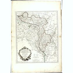
Royaume de Hongrie.
Detailed map encompassing present day Hungary with the river Danube and the towns of Belgrade, Budapest, Vienna, etc.Venetian edition of the map by Bellin, to whom Santin...
Date: Venice, 1776 - 1784
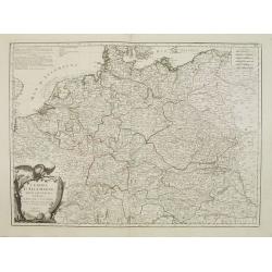
L'Empire d'Allemagne..
Detailed map encompassing Germany, the Netherlands, Belgium, Austria, and part of Poland.Venetian edition of the map by Bellin, to whom Santini gives credit in the cartou...
- $100 / ≈ €88
Date: Venice, 1776 - 1784
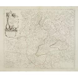
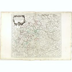
Principauté de Transilvanie et Pays circonvoisins..
Detailed map encompassing part of present-day Hungary.From "Atlas Universel" published by Santini in 1784. The atlas is effectively an Italian copy of the Rober...
Date: Venice, 1784
![[2 maps] Partie Septentrionale.. Partie Meridionale du Royaume de Portugal..](/uploads/cache/25084-250x250.jpg)
[2 maps] Partie Septentrionale.. Partie Meridionale du Royaume de Portugal..
A detailed two sheet map of Portugal showing the roads, prepared by N.Bellin. Venetian edition of the map by Bellin, to whom Santini gives credit in the cartouche.From &...
Date: Venice, 1776 - 1784
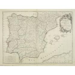
Les Royaumes d'Espagne et de Portugal, divisés Par Grandes Provinces..
Attractive map of the Iberian Peninsula. Ornated with a decorative title cartouche showing the coats of arms of Spain and Portugal.Prepared by Le Sieur Janvier, Jean deni...
Date: Venice, 1776 - 1784
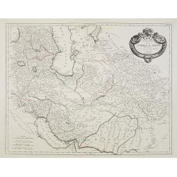
Carte de l'Empire de Perse. . .
Map of the Persian empire by the Venetian cartographer and publisher François (Père) Santini and first published in Santini's 'Atlas Universel dressée sur les meuilleures...
Date: Venice, 1784
Partie Meridionale du Cercle d'Autriche qui comprend La basse partie du Duché de Strie, Le Duché de Carinthie, divisé en haute et basse, Le Duché de Carniole. . . Et l'Istrie Impériale. . .
Uncommon, finely and crisply engraved map with large decorative title cartouche.Very detailed sheet that is centered roughly on Trieste and extends in to the mouth of the...
Date: Venice, 1784
Partie Méridionale de la Russie Europeenne ou sont distinguees exactement toutes les Provinces, d'après le detail de l'Atlas Russien.
Detailed map of southern European Russia, including Yugoslavia. The map was first published by the Venetian cartographer and publisher François (Père) Santini and first p...
Date: Venice, 1784
Gouvernements de Lorraine et d'Alsace.
Detailed map encompassing present day the east of France.Venetian edition of the map by Bonne, to whom Santini gives credit in the cartouche.From "Atlas Universel&qu...
Date: Venice, 1776 - 1784
Partie Occidentale de l'Empire de Russie en Asie. . .
Finely and crisply engraved map of the north-western part of Russia, with noteworthy topographical detail.Ornamental title cartouche in the upper left corner surrounded w...
Date: Venice, 1776 - 1784
Partie Méridionale de la Russie Europeenne ou sont distinguees exactement toutes les Provinces, d'après le detail de l'Atlas Russien.
Detailed map of southern European Russia, including Yugoslavia. The map was first published by the Venetian cartographer and publisher François (Père) Santini and first p...
Date: Venice, 1784
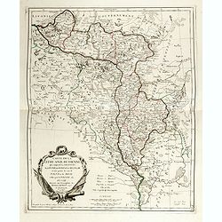
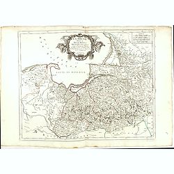
Carte de la Lithuanie Russienne qui comprend les Palatinats de Livonie, de Witepsk, de Miscislaw, et une partie de ceux de Polock et de Minsk cédés par la Pologne à la Russie.
Detailed map of the areas along the river Dnieper and Duna. Santini gives credit to Homann Heirs in the cartouche. The map was prepared by the Venetian cartographer and p...
- $500 / ≈ €439
Date: Venice, 1776 - 1784
Carte De La Prusse Occidentale ou sont tracees les Provinces cedees Par la Pologne au Roi De Prusse . . . 1775
Finely and crisply engraved map of Western Prussia, now part of Poland on the Baltic Sea, including the Bay of Danzig. With ornamental title cartouche and noteworthy topo...
- $375 / ≈ €330
Date: Venice, 1776 - 1784
La Prusse divisée en Prusse Royale et Prusse Ducale.
The map extends from Memem, Danzig and Rosienne in the North to Novigrod in the southeast and Thorn on the Wessel in the southwest. Shows the Gulf of Danzig and part of P...
Date: Venice, 1776 - 1784
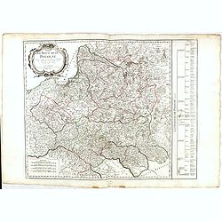
Royaume de Pologne.
Detailed map encompassing present-day Poland.Venetian edition of the map by R. de Vaugondy, to whom Santini gives credit in the cartouche.From "Atlas Universel"...
Date: Venice, 1776 - 1784
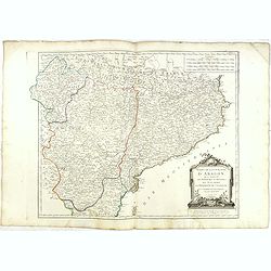
Etats de la Couronne d'Aragon...
Detailed map of the eastern part of Spain. Numerous place-names of counties, cities, towns, physical features.Prepared by "Robert de Vaugondy fils," to whom San...
Date: Venice, 1776 - 1784
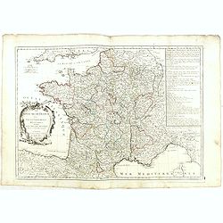
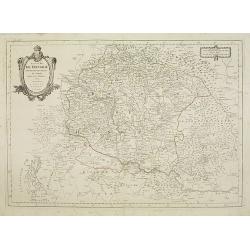
Le Royaume de France. . .
Decorative map of France with large title cartouche and a list of the "Provinces de France".Prepared by Le Sieur Janvier, Jean denis [Robert], a French geograph...
Date: Venice, 1776 - 1784
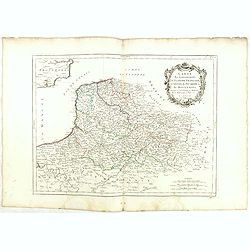
Gouvernements de Flandre Françoise, d'Artois, de Picardie. . .
Detailed map encompassing northwestern part of France, with the Channel and tip of southern England. With ornamental title cartouche and noteworthy topographical detail.T...
Date: Venice, 1776 - 1784
Gouvernement de l'Isle de France et de celui de l'Orléanois. . .
Detailed map encompassing present day north of France.Venetian edition of the map by Bellin, to whom Santini gives credit in the cartouche.From "Atlas Universel"...
Date: Venice, 1776 - 1784
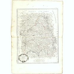
Gouvernements de Champagne et Brie.
Detailed map encompassing Champagne and Brie.Venetian edition of the map by Bonne, to whom Santini gives credit in the cartouche.From "Atlas Universel" publishe...
Date: Venice, 1776 - 1784
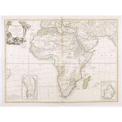
L'Afrique divisée en ses principaux Etats, assujettie aux observations astronomique.
Rare and attractive map of Africa, ornated with a decorative title cartouche showing luxuriant nature and a lion. With two inset maps : "Carte particulière du Cap d...
Date: Paris, Lattré, 1788

Teatro della guerra nelle Flandre Austriache e Francesi. . .
Rare folio-sized map of Belgium by Antonio Zatta e Figli, from a never-finished atlas by the ‘Società Calcografia’, a partnership of the two main Venetian publishers of t...
Date: Venise, 1803
