Search Listings matching "ives."
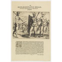
VI. Repraesentatio Bellorum, et Quomodo se ad Illa praeparent. (How the natives fight each other)
This shows how the men go to war and which weapons they use. They hold large square shields, about six feet high and four feet wide, made of cane and fortified with ox-hi...
- $90 / ≈ €79
Date: Frankfurt, 1609
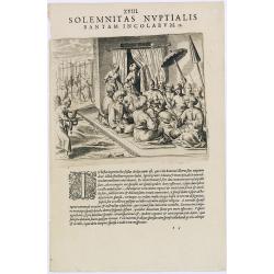
Solemnitas Nuptialis Bantam Incolarum. (A wedding ceremony in the city of Bantam)
When a young couple become engaged they do not leave their homes until the wedding takes place. On their wedding day they are dressed up and happy, and visited by all the...
- $75 / ≈ €66
Date: Frankfurt, 1609
![[Indians attacked near Cartagena.]](/uploads/cache/40076-250x250.jpg)
[Indians attacked near Cartagena.]
When the governor of Cartagena, Alonso de Ojeda, led a party of Spanish soldiers into the interior to search for gold, they were attacked by Indians with such ferocity th...
Date: Frankfurt, M.Merian, 1633
![[How the women tease their captives.]](/uploads/cache/40478-250x250.jpg)
[How the women tease their captives.]
The Indian women led their captive, Staden, into the middle of the hamlet. Then they decorated his head with feathers and his legs with rattles. After forming a circle ro...
Date: Frankfurt, M.Merian, 1633
Tartaria sive Magni Chami imperium.
Detailed and decorative map of Tartary and Northern part of China. Northern tip of Korea included. The Chinese Great Wall is depicted, with Central Asia, extending from M...
Date: Amsterdam, 1638
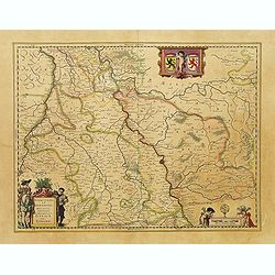
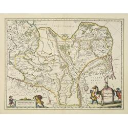
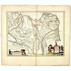
Juliacensis et Montensis Ducatus / De Hertoghdomen Gulick en Berghe.
Detailed map centered on Cologne. Embellished with scale cartouche with cherubs, a cartouche with a putti inside holding two coats of arms. Lower left corner, the title c...
- $150 / ≈ €132
Date: Amsterdam, 1645
Tartaria sive Magni Chami Imperium.
Detailed and decorative map of Tartary and Northern part of China. Northern tip of Korea included. The Chinese Great Wall is depicted, with Central Asia, extending from M...
- $550 / ≈ €483
Date: Amsterdam, 1645

Cimbebas et Caffariae Littora a Catenbela ad Promontorium. . .
The coast of Angola, South-West Africa and South Africa up to Port Elizabeth. Classic sea chart of Dutch school with excellent baroque embellishment. North oriented to th...
Date: Amsterdam, 1675
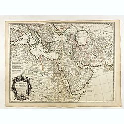
Carte de la Turquie de l'Arabie et de la Perse.
Very rare state with the address : Chez l’Auteur, Rue des Canettes prez St. Sulpice. Avec Privilège, 1701". This early state with "rue des Canettes" imprin...
Date: Paris, 1701
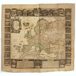
L'Europe Dressée Sur les Nouvelles observations. . .
A rare and monumental wall map of Europe, with original outline color, of four joined sheets, surrounded by text and vignettes printed on separate sheets.Created in 1740 ...
Date: Paris, 1700-1740
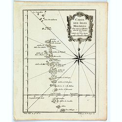
Carte des Isles Maldives.
A small detailed map of the Maldives, with rhumb lines and a large compass rose. Includes a decorative title cartouche. One of the maps produced by Nichlas Bellin for Pre...
Date: Paris, 1757

A chart of the northern part of the Indian Ocean..
Complete title in upper right "A Chart of the Northern Part of the Indian Ocean, Containing a Part of the Coast of Africa from Magadasho River to the Straits of Bab-...
Date: London 1794

New York Ferry Boat. (Bac à vapeur de New York).
A very decorative print showing the New York Ferry Boat "Fulton," published by Currier & Ives. The Ferry boat "Fulton" sails to the right. A singl...
Date: New York, ca. 1875
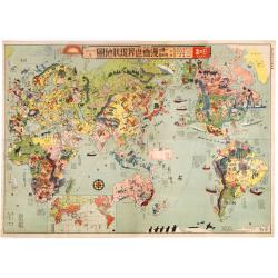
Japanese Stereotype Map of the World from 1932 Share Hitome de wakaru Manga sekai genjō chizu. At a glance: Cartoon Map of the Current World Situation. 目でわかる 漫画世界現状地圖
An extraordinary satirical map of the world was seen through Japanese eyes in the early 1930s as Japanese imperial ambitions strengthened. The map was published as an edi...
Date: Tokyo, Showa 7, or 1932
