Search Listings matching "hondius"
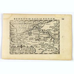
Descriptio Galliae Belgicae.
A decorative miniature map of a section of ancient France, and that of Belgium. Features a nice strap-work title, shows rivers and settlements. From the Bertius atlas Tab...
- $100 / ≈ €86
Date: Amsterdam, 1606
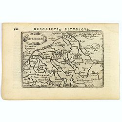
Descriptio Biturigum.
A charming small map of central France. Showing the areas around the rivers Loire, Auron, Allier and Yevre. Nevers and Bourges depicted. From the Bertius atlas Tabularum ...
- $100 / ≈ €86
Date: Amsterdam, 1606
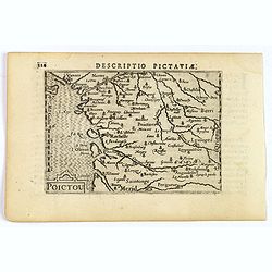
Descriptio Pictaviae.
A charming small map of Poitou in west central France. Showing Cognac, Limoges, Perigord, Poitiers and Angouleme. From the Bertius atlas Tabularum geographicarum contract...
- $100 / ≈ €86
Date: Amsterdam, 1606
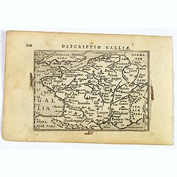
Descriptio Galliae.
A charming small map of ancient Gaul, France under Roman occupation. Featuring most major cities, rivers, mountains and regions are named. From the Bertius atlas Tabularu...
- $100 / ≈ €86
Date: Amsterdam, 1606
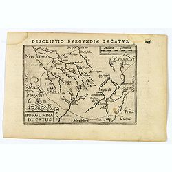
Descriptio Burgundiae Ducatus.
A decorative small map of region around Dijon, Chalons and Dole in Burgundy. Shows many rivers including the Seine, Saone and Brune. It features a nice strap-work title, ...
- $100 / ≈ €86
Date: Amsterdam, 1606
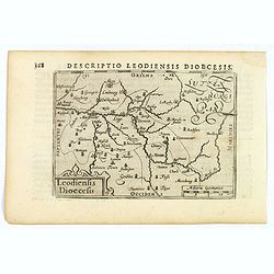
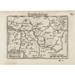
Descriptio Leodiensis Dioecesis.
A decorative map of the ancient Diocese of liege in Belgium, highlighting cities such as Huy, Liege, Tongeren (old capital), Namur and Maastricht. North is orientated to ...
- $100 / ≈ €86
Date: Amsterdam, 1606
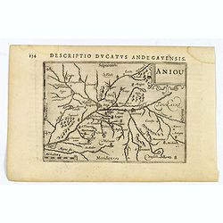
Aniou.
Anjou is a historical province of France, straddling the lower Loire River. Its capital was Angers. It bordered Brittany to the west, Maine to the north, Touraine to the ...
- $100 / ≈ €86
Date: Amsterdam, 1606
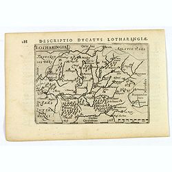
Lotharingia.
Lothringaria (Lorraine) is a historical province of N.E. France, it features the cities of Sarrebourg, Metz, Toul and Nancy. With excellent physical and topographical det...
- $100 / ≈ €86
Date: Amsterdam, 1606
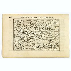
Limania.
A pleasant miniature map of the Limousin region of central France, the area surrounding Clermont Ferrand. Good map detail. From the Bertius atlas Tabularum geographicarum...
- $100 / ≈ €86
Date: Amsterdam, 1606
![Venuxinus Comitatus. [Vaucluse]](/uploads/cache/43427-250x250.jpg)
Venuxinus Comitatus. [Vaucluse]
A pleasant miniature map of the Vaucluse region of S.E. France, as published by Petrus Bertius in Amsterdam at the beginning of the seventeenth century. Many mountains as...
- $100 / ≈ €86
Date: Amsterdam, 1606
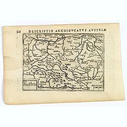
Austria.
A decorative miniature map of the area to the south of Vienna in southern Austria, published by Petrus Bertius in Amsterdam, at the beginning of the seventeenth century. ...
- $100 / ≈ €86
Date: Amsterdam, 1606
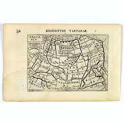
Tartaria.
A fine miniature map showing China, Korea and Russia. Title cartouche on the upper left corner. First published in 1598 in his Caert-Thresoor, the plates were executed by...
- $100 / ≈ €86
Date: Amsterdam, 1606
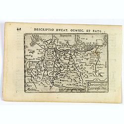
Descriptio Ducat. Ozwiec. et Zato.
An original early 17th century copper engraved miniature antique map of the Oswiecim (Auschwitz) and Zator area of southern Poland by Petrus Bertius. The title is display...
- $100 / ≈ €86
Date: Amsterdam, 1606
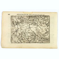
Descriptio Transisalaniae.
An original early 17th century copper engraved miniature antique map of the eastern Dutch region of Overijssel by Petrus Bertius. The title is displayed in a simple strap...
- $100 / ≈ €86
Date: Amsterdam, 1606
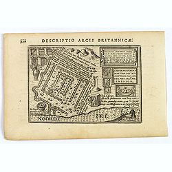
Descriptio Arcis Britannicae.
An original early 17th century copper engraved miniature antique map of the Roman remains in the sand dunes near Katwijk aan Zee in south Holland by Petrus Bertius. In Ro...
- $100 / ≈ €86
Date: Amsterdam, 1606

Ultrajectum.
An original early 17th century copper engraved miniature antique map of the Dutch province of Utrecht by Petrus Bertius, that was published in Amsterdam at the beginning ...
Date: Amsterdam, 1606
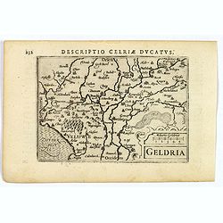
Geldria.
An original early 17th century copper engraved miniature antique map of the Dutch province of Gelderland by Petrus Bertius, that was published in Amsterdam at the beginni...
- $100 / ≈ €86
Date: Amsterdam, 1606
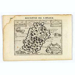
Sancta Helena.
An attractive small map of the south Atlantic island of St. Helena. Two years after the publication of the Itinerario, the first map of St. Helena appeared in 1598 in a m...
- $100 / ≈ €86
Date: Amsterdam, 1606
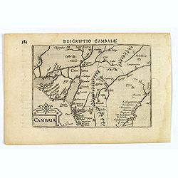
Descriptio Cambaiae.
A very decorative little map of northern India with Gujarat and the Indus river, bordering Pakistan. Naming major towns represented by symbols, major rivers, mountains, a...
- $100 / ≈ €86
Date: Amsterdam, 1606
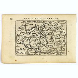
Savoie.
A decorative miniature map of Savoy - a cultural region in Central Europe that comprises roughly the territory of the Western Alps between Lake Geneva in the north and Da...
- $100 / ≈ €86
Date: Amsterdam, 1606
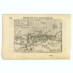
Descriptio Provinciae.
A decorative miniature map of Provence - a geographical region and historical province of south-eastern France, which extends from the left bank of the lower Rhône River...
- $100 / ≈ €86
Date: Amsterdam, 1606
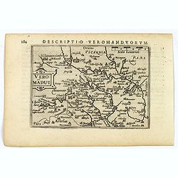
Descriptio Veromanduorum.
A decorative miniature map of Aisne (Vermandois), a French department in the Hauts-de-France region of northern France. It is named after the river Aisne. The map is cent...
- $100 / ≈ €86
Date: Amsterdam, 1606
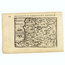
Artesia.
A decorative miniature map of Artois, a historical northern French province that borders Belgium. A map full of detail and is expertly engraved. With the cities of Boulo...
- $100 / ≈ €86
Date: Amsterdam, 1606
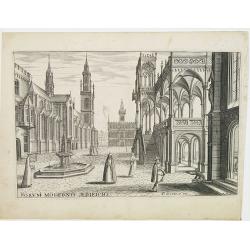
Perspective print by Vredeman de Vries.
Engraving from Les cinq rangs de l'architecture, a savoir, Tuscane, dorique, ionique, corinthiaque et composée avec l'instruction fondamentale. by Paul Vredeman de Vries...
Date: The Hague, 1606
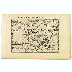
Picardia.
A decorative miniature map of Picardy, a historical northern French region. A map that appears to be sparsely populated is still full of detail with great attention to de...
- $100 / ≈ €86
Date: Amsterdam, 1606
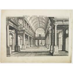
Perspective print by Vredeman de Vries.
Engraving from Les cinq rangs de l'architecture, a savoir, Tuscane, dorique, ionique, corinthiaque et composée avec l'instruction fondamentale. by Paul Vredeman de Vries...
Date: The Hague, 1606
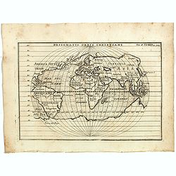
Designatio Orbis Christiani
Planispherical world map broadly based on Ortelius and similar to Hondius's Atlas Minor map of the same title. It shows most of the world, excluding the west coast of Nor...
- $450 / ≈ €388
Date: France, ca 1607
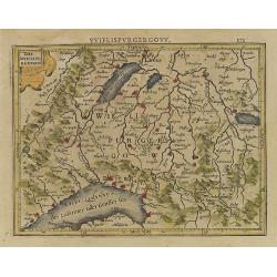
Das Wiflispurgergou.
Reduced version of Mercator''s map of the southwestern part of Switzerland. Shows Geneva, Lake Geneva, Lake Neuchatel, Lake Biel, Bern, Freiburg, Lake Thuner, etc.From th...
- $75 / ≈ €65
Date: Amsterdam, 1608

Polus Arcticus cum vicinis regionibus.
Map of the North Pole regions from the 1608 second edition of Jodocus Hondius' Atlas Minor.A reduction of the 1606 Mercator-Hondius folio map (which is a later state of t...
Date: Amsterdam, 1608
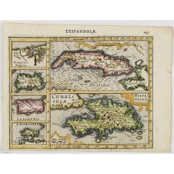
Cuba Insula. Hispaniola.
Decorative engraved map of Cuba above Hispaniola with smaller insets of Havana, Jamaica, Puerto Rico and Margarita.From the first French-text edition of Jodocus Hondius''...
- $300 / ≈ €259
Date: Amsterdam, 1608
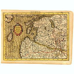
Livonia.
Scarce miniature map of Lithuania, from the first French-text edition of Jodocus Hondius' Atlas Minor. Engraved by Pieter Van Den Keere.Shortly after the publication of t...
- $300 / ≈ €259
Date: Amsterdam, Cloppenburgh, 1608
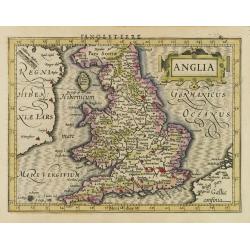
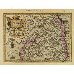
Anglia.
Map of England, from the first French-text edition of Jodocus Hondius'' Atlas Minor.Shortly after the publication of the big folio-atlases the need was apparently felt fo...
- $150 / ≈ €129
Date: Amsterdam, 1608
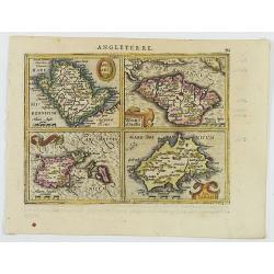
Anglesey Ins. / Wight.. / Ins. Garnesey. / Ins. Iarsey.
A reduced version of Mercator's folio map with four maps on one sheet depicting the English islands of Jersey, Guernsey, Wright and Alderney.Each map is embellished with ...
- $150 / ≈ €129
Date: Amsterdam, 1608
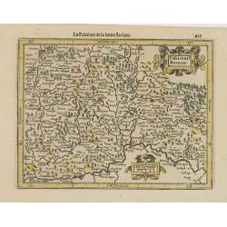
Palatinat. Bavariae.
Detailed map showing part of Bavaria. It covers the area between Ingolstadt, Nuremberg and Regensburg.From the first French-text edition of Jodocus Hondius' Atlas Minor.S...
- $50 / ≈ €43
Date: Amsterdam, 1608
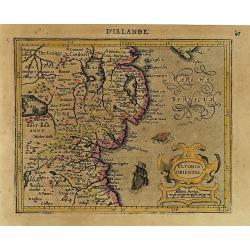
Ultonia Oriental.
Map depicting part of Ulster, with the south-western tip of Scotland in the upper right. From the first French-text edition of Jodocus Hondius' Atlas Minor.Shortly after ...
- $75 / ≈ €65
Date: Amsterdam, 1608
Northumbr. Cumberladia Dunelm. Episcop.
A map of the most northern part of England, from the first French-text edition of Jodocus Hondius' Atlas Minor.Shortly after the publication of the big folio-atlases the ...
- $100 / ≈ €86
Date: Amsterdam, 1608
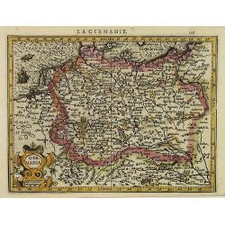
La Germanie.
Small map of Germany, including Austria and part of Poland. Strap work title cartouche in the lower left.From the first French-text edition of Jodocus Hondius' Atlas Mino...
- $75 / ≈ €65
Date: Amsterdam, 1608
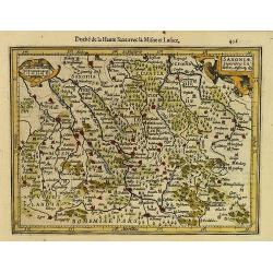
Saxonia Inferior et Mekleburg.
Detailed map showing part of northern Germany. With major cities of the area named.From the first French-text edition of Jodocus Hondius' Atlas Minor.Shortly after the pu...
- $80 / ≈ €69
Date: Amsterdam, 1608
Saxoniae Superioris Lusatiae..
Detailed map of Saxony. With Prague at the bottom. From the first French-text edition of Jodocus Hondius' Atlas Minor.Shortly after the publication of the big folio-atlas...
- $50 / ≈ €43
Date: Amsterdam, 1608
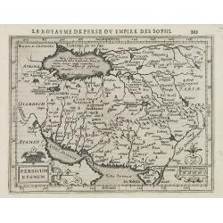
Persicum Regnum.
Early map of Persia, from the first French-text edition of Jodocus Hondius' Atlas Minor.Shortly after the publication of the big folio-atlases the need was apparently fel...
- $100 / ≈ €86
Date: Amsterdam, 1608
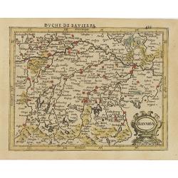
Bavaria.
Detailed map showing part of Bavaria. It covers the area between Ingolstadt and Salzburg.From the first French-text edition of Jodocus Hondius' Atlas Minor.Shortly after ...
- $50 / ≈ €43
Date: Amsterdam, 1608
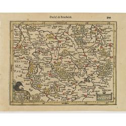
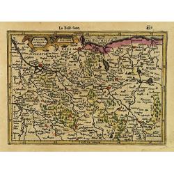
Brauswik et Meydburg com confinijs.
Detailed map showing the region around Brunswick and Magdeburg. With major cities of the area named.From the first French-text edition of Jodocus Hondius' Atlas Minor.Sho...
- $50 / ≈ €43
Date: Amsterdam, 1608
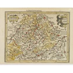
Wirtenberg.
Detailed map centered on Baden-Württemberg. With major cities of the area named.From the first French-text edition of Jodocus Hondius' Atlas Minor. Shortly after the p...
- $40 / ≈ €35
Date: Amsterdam, 1608
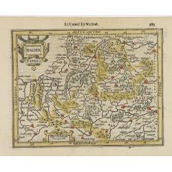
Waldek Comit.
Early map of the region surrounding Waldeck, northern Hessen. From the first French-text edition of Jodocus Hondius' Atlas Minor.Shortly after the publication of the big ...
- $45 / ≈ €39
Date: Amsterdam, 1608

Udrone.
Map depicting present-day County Carlow in Leinster Province & Catherlaugh which is now Carlow. From the first French-text edition of Jodocus Hondius' Atlas Minor.Sho...
- $150 / ≈ €129
Date: Amsterdam, 1608
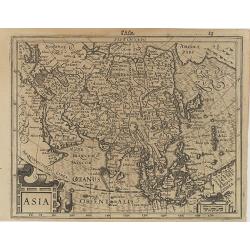
Asia.
Map of Asia with an oversized Korea and a curious shape for Japan, from the first French-text edition of Jodocus Hondius' Atlas Minor.Shortly after the publication of the...
Date: Amsterdam, 1608
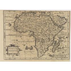
Africae Descriptio.
Map of Africa from the first French-text edition of Jodocus Hondius' Atlas Minor.Shortly after the publication of the big folio-atlases the need was apparently felt for a...
Date: Amsterdam, 1608
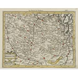
Brabantia.
Decorative regional map of northern Belgium and the Dutch province Brabant, extending north to Breda and south to Namur, with Antwerp and Brussels near the center.Oriente...
- $150 / ≈ €129
Date: Amsterdam, 1608
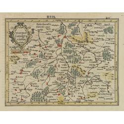
Hassia Landgraviatus.
Detailed map showing the region around Kassel. With major cities of the area named.From the first French-text edition of Jodocus Hondius' Atlas Minor.Shortly after the pu...
- $50 / ≈ €43
Date: Amsterdam, 1608
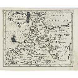
Fessae Regnum.
Charming small map of the northwestern tip of Africa with Fez showing as the principal city. Decorative title cartouche.From a Latin-text edition of Jodocus Hondius' Atla...
- $120 / ≈ €104
Date: Amsterdam, 1608
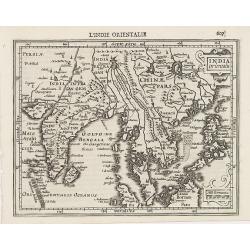
Indiae Orientalis.
This map covers an area including India, part of Malaysia, Borneo and China.From the first French-text edition of Jodocus Hondius' Atlas Minor.Shortly after the publicati...
Date: Amsterdam, 1608
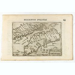
Sumatra Insula.
A miniature map of Sumatra containing detailed geography and nomenclature around the entire island. The neighbouring coast of the Malay Peninsula is shown, including Sing...
- $450 / ≈ €388
Date: Amsterdam/Frankfurt 1609
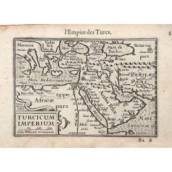
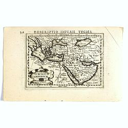
Turcicum Imperium / Empire Turc.
A miniature map of the Arabian peninsula, centered on Jerusalem. Title cartouche on the lower left corner.First published in 1598 in his Caert-Thresoor, the plates were e...
Date: Amsterdam/Frankfurt 1609
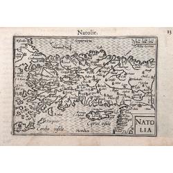
Natolia.
A miniature map of the Arabian peninsula, including Cyprus. The title cartouche on the lower right corner.First published in 1598 in his Caert-Thresoor, the plates were e...
- $200 / ≈ €173
Date: Amsterdam / Frankfurt, 1609
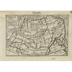
Tartaria.
A miniature map showing China, Korea and Russia. Title cartouche on the upper left corner.First published in 1598 in his Caert-Thresoor, the plates were executed by the m...
Date: Amsterdam, 1609
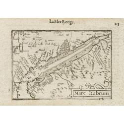
Mare Rubrum / Mer Rouge.
Wonderful miniature map includes the Red Sea, Yemen, and the east coast of the Arabian peninsula. One of the early maps to focus on this area. The title cartouche on the ...
Date: Amsterdam / Frankfurt, 1609

Maldivae Insulae.
Very fine early miniature map of Maldives Islands. East is at the top. Title cartouche on the lower right corner. A dolphin and two ships are depicted.First published in ...
Date: Amsterdam / Frankfurt, 1609

Sumatra Insula.
A miniature map of Sumatra and the Malay Peninsula, including Singapore and the various islands directly south of it. Containing detailed geography and nomenclature aroun...
Date: Amsterdam, 1609
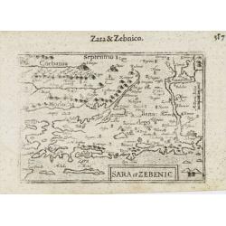
Sara et Zebenic.
A miniature map of the islands of Dalmatia. Title cartouche on the lower left side.First published in 1598 in his Caert-Thresoor, the plates were executed by the most fam...
- $100 / ≈ €86
Date: Amsterdam / Frankfurt, 1609
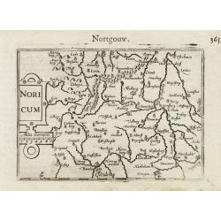
Noricum.
A miniature map showing a part of Bavaria, including the cities of Bamberg and Nuremberg. Title cartouche on the left side.First published in 1598 in his Caert-Thresoor, ...
- $50 / ≈ €43
Date: Amsterdam / Frankfurt, 1609
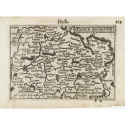
Hassiae Descriptio / Hesse.
A miniature map centered on the province of Hessen. The title cartouche on the upper right corner.First published in 1598 in his Caert-Thresoor, the plates were executed ...
- $50 / ≈ €43
Date: Amsterdam / Frankfurt, 1609

Biturigum.
A miniature map of the Berry. Fine cartouche in the upper left corner.First published in 1598 in his Caert-Thresoor, the plates were executed by the most famous engravers...
Date: Amsterdam/Frankfurt 1609
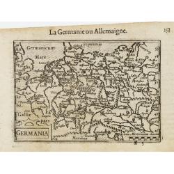
Germania.
A miniature map of Germany. The title cartouche on the lower left corner. First published in 1598 in his Caert-Thresoor, the plates were executed by the most famous engra...
- $75 / ≈ €65
Date: Amsterdam/Frankfurt, 1609
Leodiensis Dioecesis.
A miniature map of the southern part of Belgium centered on Liege. The title cartouche on the lower left corner.First published in 1598 in his Caert-Thresoor, the plates ...
- $75 / ≈ €65
Date: Amsterdam / Frankfurt, 1609

Die Zyp / La Zype.
A miniature map showing the polder of De Zype. Title cartouche in the upper side.First published in 1598 in his Caert-Thresoor, the plates were executed by the most famou...
Date: Amsterdam / Frankfurt, 1609
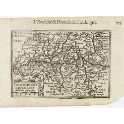
Coloniensis Diocesis.
A miniature map centered on Cologne. Title cartouche on the lower left corner.First published in 1598 in his Caert-Thresoor, the plates were executed by the most famous e...
- $80 / ≈ €69
Date: Amsterdam / Frankfurt, 1609
![[Title page] Germaniae Tabule Geographicae ...](/uploads/cache/43267-250x250.jpg)
[Title page] Germaniae Tabule Geographicae ...
This is the title page to the volume of the atlas devoted to maps of Germany. According to Shirley the "early sectional parts of his "Atlas" each had Manne...
Date: Amsterdam, 1585-c.1610
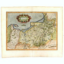
Prussia .
Important early map showing coast of Baltic Sea in Prussia, today Poland, prepared by the German cartographer Gaspher Henneberg of Erlich. Embellished with a large strapw...
Date: Amsterdam, 1612
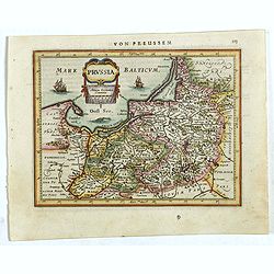
Prussia .
An early map of northern Poland from the "Atlas Minor" (Gerhard Mercator / Jodocus Hondius). Extends from Memel to Torun and the Narew River. With two sailing s...
- $300 / ≈ €259
Date: Amsterdam, 1612
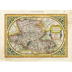
Comitatus Hannonia.
Detailed map of the Belgium province Hainault or Henegouwen. Including the towns of Mons, Geraadsbergen, etc.Uncommon and decorative oval map in a rectangular frame, the ...
- $100 / ≈ €86
Date: Amsterdam, 1616
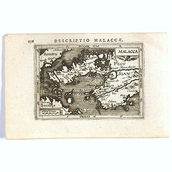
Malacca.
FIRST IMPRINT FROM THE NEWLY ENGRAVED PLATES IN 1616. - A rare miniature map of Malacca, Borneo, part of Sumatra . Latin text on verso.First published in 1598 in his Caer...
Date: Amsterdam, J. Hondius, 1616
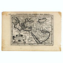
Turcicum Imperium.
FIRST IMPRINT FROM THE NEWLY ENGRAVED PLATES IN 1616. - A rare miniature map of the Arabian Peninsular. Title cartouche on the lower left corner.First published in 1598 i...
- $500 / ≈ €432
Date: Amsterdam, J. Hondius, 1616
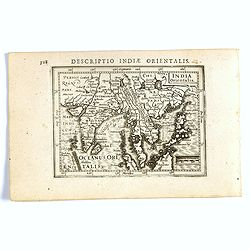
India Orientalis.
FIRST IMPRINT FROM THE NEWLY ENGRAVED PLATES IN 1616. - A rare miniature map of the East Indies.First published in 1598 in his Caert-Thresoor, the plates were executed by...
Date: Amsterdam, J. Hondius, 1616
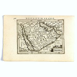
Arabia.
FIRST IMPRINT FROM THE NEWLY ENGRAVED PLATES IN 1616. - A rare miniature map of the Arabian Peninsular. Title cartouche on the lower left corner.First published in 1598 i...
Date: Amsterdam, J. Hondius, 1616
Turicum imperium.
FIRST IMPRINT FROM THE NEWLY ENGRAVED PLATES IN 1616. - A rare miniature map of the Ottoman empire with Turkey and the Arabian Peninsular. Title cartouche on the lower le...
Date: Amsterdam, J. Hondius, 1616
![[Lot of 6 Maps of Germany] PALATINATUS BAVARIAE.](/uploads/cache/IMG_2319-250x250.jpg)
[Lot of 6 Maps of Germany] PALATINATUS BAVARIAE.
[Lot of 6 Maps of Germany]- Palatinatus Bavariae. (H.Hondius & G.Mercator) circa. 1619 (490x370 mm)- La Basse Partie Du Cercle Du Haut Rhein divisé en tous ses ...
- $750 / ≈ €647
Date: Amsterdam, 1619
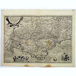
Provinciae, Regionis galliae, vera exactissimaq. Descriptio
This is a highly detailed and well engraved map of Provence in southern France. Engraved by H.Picart and published by Jean le Clerc.Jean le Clerc (1560-1621) was an engra...
- $500 / ≈ €432
Date: Paris, ca. 1620
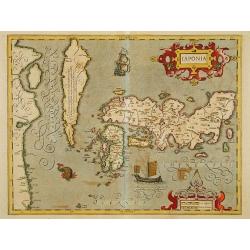
Japonia.
Jodocus Hondius' fine map early 17th-century map of the islands of Japan, was first issued as one of the new maps in the expended Mercator Hondius Atlas of 1606.The map i...
Date: Amsterdam, 1606-1620
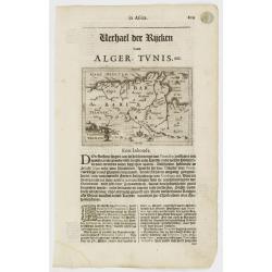
Tunetanum Regnum.
Small map representing Tunisia and Algeria, surrounded by text in Dutch.Nicolaes de Clerck (de Klerc) was active as engraver and publisher in Delft from 1599-1621.Include...
Date: Amsterdam, Cloppenburch, 1621
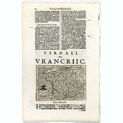
Gallia.
Small map of France, surrounded by text in Dutch. Nicolaes de Clerck (de Klerc) was active as engraver and publisher in Delft from 1599-1621.Included in the rare book : W...
- $70 / ≈ €60
Date: Amsterdam, Cloppenburch, 1621