Browse Listings in Map Types > Nautical Charts
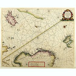
De custen van Noorwegen, Finmarcken, Laplandt, Spitsbergen . . .
Two sea charts on one sheet showing Norway, Finland, Iceland, Spitsbergen and part of Scotland. The chart includes a detailed plan of the coastlines, soundings, anchorage...
Place & Date: Amsterdam, 1666

.Pascaerte Van't Westelyckste der Middelandsche Zee. . .
An eye-catching chart of the western part of the Mediterranean Sea.Pieter Goos (ca. 1616-1675) was one of the most important cartographer, engraver, publisher and print s...
Place & Date: Amsterdam, 1666
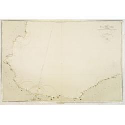
Carte de la Mer Noire. (1e Feuille). Du Bosphore à Mangalia et du Bosphore au Cap Kerempeh.
Very detailed chart of the Turkish part of the Black Sea including the towns of Constantinople (Istanbul) , Bourgas. Showing soundings in meters, lighthouses are marked w...
Place & Date: Paris, 1860, updated for 1870
![[East coast of Africa, Arabia and west coast of India.]](/uploads/cache/04762-250x250.jpg)
[East coast of Africa, Arabia and west coast of India.]
Rare. Map of the east coast of Africa, Including Madagascar, the Arabian Peninsular, coast of Pakistan and west coast of India.Prepared by Joao Teixeira in 1649, this cha...
Place & Date: Paris, 1664-1696
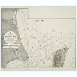
Australia, E. coast - Queensland Moreton Bay
Large chart representing East coast of Australia with Moreton Bay in Queensland.After a survey by Comr. J.Jeffery, etc. in 1865. New edition at the Admiralty 1870. With ...
Place & Date: London, 1882-1945

Pascaart van de west cust van Engeland en Wales Van S. Davids Point tot de Moul van Dalway.
Rare Doncker's sea chart of the Irish Sea with the west Coast of England (Liverpool), the Island of Man and the western-most tip of Northern Ireland (Bangor) and Souther...
Place & Date: Amsterdam, 1660-1668

Paskaerte Vande Bocht van Vranckrijk Biscajen en Galissen
An eye-catching chart of Spain and France, including a large part of Brittany, including Isle de Reé , Isle Saint Martin ...Shows the gulf of the northeast Atlantic Ocea...
Place & Date: Amsterdam, 1669-1676
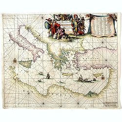
Orientalior districtus Maris Mediterranei.
Beautiful chart of the eastern part of the Mediterranean. Including Italy, the north coast of Africa and part of the Black Sea.The entire sheet is covered with rhumb line...
Place & Date: Amsterdam, 1675
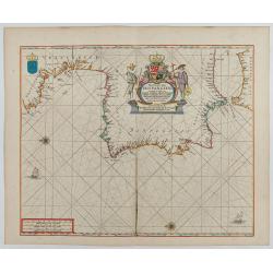
Pas-Caart van Hispangien vertoonde de Custen van Granade…
An eye-catching chart of Spain and Portugal, including a large part of Brittany and the southwestern coast of France, including Isle de Reé , Isle Saint Martin ...Pieter...
Place & Date: Amsterdam, 1669-1676
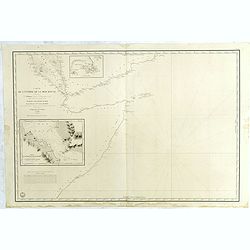
Carte de L'Entrée de la Mer Rouge. Dressée par M.Daussy. . .
Very large and detailed chart depicting the entrance of the Red Sea, including the coastline of Yemen with inset "Carte du détroit de Bab!el-Mandeb. . ." and &...
- $750 / ≈ €702
Place & Date: Paris, ca. 1840