Browse Listings in Map Types
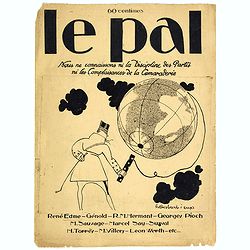
Le Pal - Nous ne connaissons ni la discipline des partis ni les complaisances de la camaraderie.
Original cover design in pen and ink by Henri Desbarbieux for the satirical bi-monthly journal Le Pal.Not much information is found about Henri Desbarbieux. In this BNF l...
- $300 / ≈ €281
Place & Date: Paris, 1925
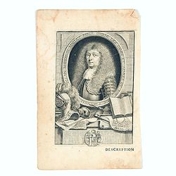
Allain Manesson Mallet Pairisi, Ingeni Des Camps Et Armees du Roy de Protugal.
Portrait of Alain Manesson Mallet, engraved by Pierre Landry, from "Description de l'Univers".
- $110 / ≈ €103
Place & Date: Paris, 1683

Comitatus Flandria.
First published by the van Langrens c.1595, after his acquisition of the plate, Visscher heavily re-engraved the map, inserting panelled borders on three sides (the lower...
Place & Date: Amsterdam, c. 1630
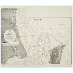
Australia, E. coast - Queensland Moreton Bay
Large chart representing East coast of Australia with Moreton Bay in Queensland.After a survey by Comr. J.Jeffery, etc. in 1865. New edition at the Admiralty 1870. With ...
Place & Date: London, 1882-1945
![[Title page] Gli Argonauti.](/uploads/cache/23338-250x250.jpg)
[Title page] Gli Argonauti.
Decorative title page illustrating allegorical and mythological figures. Engraved by Alessandro Dalla Via after a drawing by Lodovico Lanberti.At the top some cherubs car...
Place & Date: Venice, ca. 1720
![[Four cartouche cuttings one sheet]](/uploads/cache/30307-250x250.jpg)
[Four cartouche cuttings one sheet]
Four cut-outs of scale cartouches from Johannes Janssonius plates. Cartouches featuring natives and merchants.
Place & Date: Amsterdam, c.1650
![[East coast of Africa, Arabia and west coast of India.]](/uploads/cache/04762-250x250.jpg)
[East coast of Africa, Arabia and west coast of India.]
Rare. Map of the east coast of Africa, Including Madagascar, the Arabian Peninsular, coast of Pakistan and west coast of India.Prepared by Joao Teixeira in 1649, this cha...
Place & Date: Paris, 1664-1696
![[Title page] De insectis libri III, de serpentibus et draconibus libr II.](/uploads/cache/22364-250x250.jpg)
[Title page] De insectis libri III, de serpentibus et draconibus libr II.
Title page from : Historiae Naturalis de Quadrupedibus libri.The re-edition of the edition of Frankfurt of 1650-53 illustrated with mirror imaged copper engravings after ...
Place & Date: Amsterdam, 1657
Pas-Caart van Hispangien vertoonde de Custen van Granade…
An eye-catching chart of Spain and Portugal, including a large part of Brittany and the southwestern coast of France, including Isle de Reé , Isle Saint Martin ...Pieter...
Place & Date: Amsterdam, 1669-1676

Pascaart van de west cust van Engeland en Wales Van S. Davids Point tot de Moul van Dalway.
Rare Doncker's sea chart of the Irish Sea with the west Coast of England (Liverpool), the Island of Man and the western-most tip of Northern Ireland (Bangor) and Souther...
Place & Date: Amsterdam, 1660-1668