Browse Listings in Map Types > Nautical Charts

Nieuwe Wassende Graade Zee Kaart over de Spaanse Zee Vant Kanaal tot 't Eyland Cuba in Westindia. . .
¤ Engraved by I.van Anse. A very representative example of a Dutch chart of the Atlantic, showing the north-east coast of America, the coasts of Africa and Europe and So...
Place & Date: Amsterdam, 1728

Tractus Littorales Guineae a Promontorio Verde usque ad sinum Catenbelae.
Chart of the West coast of Africa from Mauritania up to Angola. In top centre a very decorative title cartouche.
Place & Date: Amsterdam, 1675

Noordoost Cust van Asia van Japan tot Nova Zembla.
Important for its early depiction of Hokkaido and the Islands to the North of Japan. Ships navigate the seas around the Siberian, Chinese and Japanese coast extending as ...
- $3000 / ≈ €2807
Place & Date: Amsterdam, 1666

De Texel Stroom .. vant Marsdiep./ Caarte van De Mase...
Two decorative charts on one sheet, one depicting Texel and the entrance of the Zuider Zee with an inset showing the north coast of West-Friesland, the other depicting th...
- $750 / ≈ €702
Place & Date: Amsterdam, 1660

De Tesselstroom met de Gaten van Marsdiep./ De Mase met. . .
Three charts on one sheet depicting the entrances to the Zuiderzee between Holland, Texel and Vlieland. The entrances of the Maas with Rotterdam and in a small inset the ...
- $500 / ≈ €468
Place & Date: Amsterdam, 1662

A chart of the northern part of the Indian Ocean..
Chart of the northern part of the Indian Ocean, including part of Arabia, India and Sri Lanka prepared by D'Apré de Mannevillette and published in London by Laurie and W...
- $750 / ≈ €702
Place & Date: London 1794

Manuscript plan of Havana harbour.
Manuscript chart with good nautical detail and soundings of Havana harbour.
Place & Date: Spain c.1820
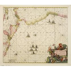
Nova Hispaniae, Chili, Peruviae, et Guatimalae Littorae..
A superbly decorative chart, oriented with north to the left of the sheet, covering the coasts of Central America, Peru, Chile, Jamaica and part of Cuba and Porto Rico. S...
- $1000 / ≈ €936
Place & Date: Amsterdam, 1660

Carte de la Manche. . .
Decorative chart showing the Chanel, with the coastline of France from La Baie de Douarnenez to Dunkerque, and the coastline of England from Stroble head to Manning Tree....
Place & Date: Amsterdam, 1692

Carte de la Baye et du Port de Trinquemalay dans L'Isle de Ceylan.
Chart showing the bay of Trincomalee, Ceylon (Sri Lanka). Trincomalee is natural deep water port on the east coast of Sri Lanka, about 110 miles northeast of Kandy. It is...
- $250 / ≈ €234
Place & Date: Paris, 1775