Browse Listings in Map Types
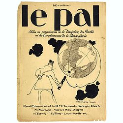
Le Pal - Nous ne connaissons ni la discipline des partis ni les complaisances de la camaraderie.
Original cover design in pen and ink by Henri Desbarbieux for the satirical bi-monthly journal Le Pal.Not much information is found about Henri Desbarbieux. In this BNF l...
- $300 / ≈ €281
Place & Date: Paris, 1925

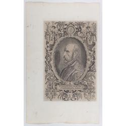
Allain Manesson Mallet Pairisi, Ingeni Des Camps Et Armees du Roy de Protugal.
Portrait of Alain Manesson Mallet, engraved by Pierre Landry, from "Description de l'Univers".
- $110 / ≈ €103
Place & Date: Paris, 1683
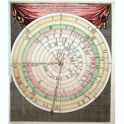
Discus Chronologicus Regum utriusque Siciliae et Ducum Princ
Chronological volvelle table showing the Sicilian rulers from the year 0 until 1730. COMPLETE with its volvelle.
Place & Date: Nuremberg, 1750
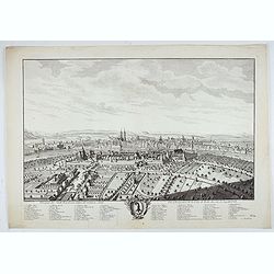
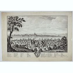
Prospect der Statt Basel von Seiten der Kleinen Statt - Vüe et Perspective de la Ville de Bâle du côté de la petite Ville.
Very decorative view of Basle, after a design by Emanuel Büchel and engraved by Johann Martin Weiss. The legend inscribed under the engraving, numbered from 1 to 10, des...
Place & Date: Basle, 1745
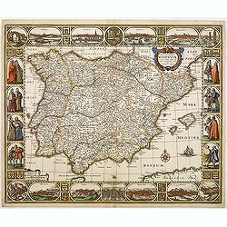
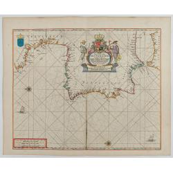
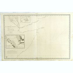
Nova et accurata Tabula Hispaniae. . .
Second state. This "carte à figures"- map of Spain and Portugal shows the geographical image introduced by Hessel Gerritsz's 1612 wall map of Spain. The map is...
Place & Date: Amsterdam, 1633
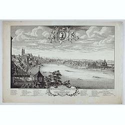
Prospect der Statt Basel von Seiten der Schlösser - Vuë et Perspective de la Ville de Bale du coté des Chateaux de Gundeldingue.
Very decorative view looking towards Basel from the castle at Gundeldingen, on a hill to the south. Accompanied at the bottom by a cartouche containing the arms of the ci...
Place & Date: Basle, ca. 1745
Prospect der Statt Basel von der St Alban Vorstraat - Vu¨e et perspective de la ville de Bâle du côté du Faubourg de St Albon.
Very decorative view of Basel, after a design by Emanuel Büchel and engraved by Johann Martin Weiss. Numbered 'No.1' in the bottom right, from a rare series of 4 sheets.
Place & Date: Basle, ca. 1745
(Title page) Recueil d'ornemen dédié a Monsieur en l'année 1777.
Beautiful title page. In the center a medallion with the portrait of Louis Stanislas Xavier de Bourbon. He was King of France and of Navarre from 1814 to 1824, omitting t...
Place & Date: Aix en Provence, 1777
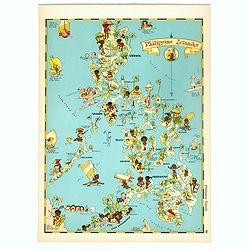
Philippines Islands.
Pictorial map of Philippines Islands, from the famous illustrator, Ruth Taylor White and published in "Our USA: A Gay Geography".Ruth Taylor White was among the...
Place & Date: Boston, Little, Brown and Company, 1935
Selling price: $250
Sold in 2018

A new mape of Ye XVII Provinces of Low Germanie.
Showing all 17 Provinces of the Netherlands before the split between Spain and the Protestant Provinces under the House of Orange.The map was first published. At the same...
Place & Date: London, 1676
![[Frontispiece] Atlas Général et Elémentaire Pour l'Etude de la Géographie et de l'Histoire moderne..](/uploads/cache/24168-250x250.jpg)
[Frontispiece] Atlas Général et Elémentaire Pour l'Etude de la Géographie et de l'Histoire moderne..
Allegoric frontispiece, from Atlas Général et Élémentaire pour l'Etude de la Géographie et de l'Histoire moderne. Engraved by K.Audran.
Place & Date: Paris, 1786
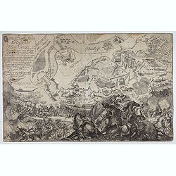
Delineatione della Piazza Forza di Belgrado.
Bird's-eye-bird view of The siege of Belgrade by the Austrian troops under the command of Prince Eugene of Savoy to capture the strategically important city from the Otto...
Place & Date: Rome, ca. 1700

Carte d'Asie divisée en ses principaux Etats.
Uncommon and decorative "carte à figures" wall map, prepared by Clouet, with superb decoration including a wonderful rococo border with vignettes describing hi...
Place & Date: Paris, Mondhare, 1787
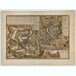
Hierosolymia, Clarissima totius Orientis civitas. . .
Two bird's eye perspectives on one sheet. The left plan shows ancient Jerusalem at the time of Christ. A contemporary view of Jerusalem appears to the right with an attra...
Place & Date: Cologne, 1582
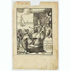
(Title page) Description de L'Univers de l'Europe ancienne et Moderne Tome IV.
Finely etched page from the French text edition of Description d'Univers.. , published in 5 volumes in 1683 by Allain Manneson Mallet (1630-1706), a well travelled milita...
Place & Date: Paris, 1683
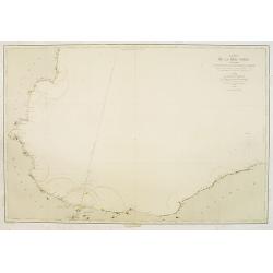
Carte de la Mer Noire. (1e Feuille). Du Bosphore à Mangalia et du Bosphore au Cap Kerempeh.
Very detailed chart of the Turkish part of the Black Sea including the towns of Constantinople (Istanbul) , Bourgas. Showing soundings in meters, lighthouses are marked w...
Place & Date: Paris, 1860, updated for 1870
![Veduta di Istambul. [Gouache]](/uploads/cache/45368-250x250.jpg)
Veduta di Istambul. [Gouache]
Very decorative view depicting Istanbul, in the style of Neapolitan gouaches. Features different Mosques and the shores of the Bosporus. Many ships, small and large, are ...
Place & Date: Italy ?, ca. 1870
![[Title page ] Il Globo Atalante di carte geografiche compilate da F.C. Marmocchi per servire di corredo al suo Corso di geografia commerciale.]](/uploads/cache/45291-250x250.jpg)
[Title page ] Il Globo Atalante di carte geografiche compilate da F.C. Marmocchi per servire di corredo al suo Corso di geografia commerciale.]
Title page prepared for Francesco Costantino Marmocchi's Atlas "Il Globo Atlante di carte Geografiche compilate da F.C. Marmocchi per servire di corredo al suu corso...
Place & Date: Genova, Paolo Rivara fu Giacomo, 1858

Comitatus Flandria.
First published by the van Langrens c.1595, after his acquisition of the plate, Visscher heavily re-engraved the map, inserting panelled borders on three sides (the lower...
Place & Date: Amsterdam, c. 1630
![[Title page] Gli Argonauti.](/uploads/cache/23338-250x250.jpg)
[Title page] Gli Argonauti.
Decorative title page illustrating allegorical and mythological figures. Engraved by Alessandro Dalla Via after a drawing by Lodovico Lanberti.At the top some cherubs car...
Place & Date: Venice, ca. 1720
![[Four cartouche cuttings one sheet]](/uploads/cache/30307-250x250.jpg)
[Four cartouche cuttings one sheet]
Four cut-outs of scale cartouches from Johannes Janssonius plates. Cartouches featuring natives and merchants.
Place & Date: Amsterdam, c.1650
![[East coast of Africa, Arabia and west coast of India.]](/uploads/cache/04762-250x250.jpg)
[East coast of Africa, Arabia and west coast of India.]
Rare. Map of the east coast of Africa, Including Madagascar, the Arabian Peninsular, coast of Pakistan and west coast of India.Prepared by Joao Teixeira in 1649, this cha...
Place & Date: Paris, 1664-1696
![[Title page] De insectis libri III, de serpentibus et draconibus libr II.](/uploads/cache/22364-250x250.jpg)
[Title page] De insectis libri III, de serpentibus et draconibus libr II.
Title page from : Historiae Naturalis de Quadrupedibus libri.The re-edition of the edition of Frankfurt of 1650-53 illustrated with mirror imaged copper engravings after ...
Place & Date: Amsterdam, 1657
Pas-Caart van Hispangien vertoonde de Custen van Granade…
An eye-catching chart of Spain and Portugal, including a large part of Brittany and the southwestern coast of France, including Isle de Reé , Isle Saint Martin ...Pieter...
Place & Date: Amsterdam, 1669-1676

Paskaerte Vande Bocht van Vranckrijk Biscajen en Galissen
An eye-catching chart of Spain and France, including a large part of Brittany, including Isle de Reé , Isle Saint Martin ...Shows the gulf of the northeast Atlantic Ocea...
Place & Date: Amsterdam, 1669-1676
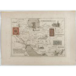
Persische Teppichknüpfgebiete und Stämme.
Map of Iran and neighboring countries in German language, published in limited edition probably in France : "Gravée à l'eau-forte et au burin. Edition limitée&quo...
Place & Date: France ?, after 1935 - before 1991

Carte d'Europe divisée en ses Empires et Royaumes.
Uncommon and decorative wall map of Europe, prepared by Clouet. Superb decoration including a wonderful rococo border with vignettes describing historical scenes. Below t...
Place & Date: Paris, Mondhare, 1788
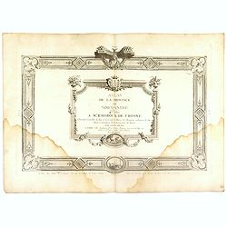
(Title page) Atlas de la Province de Normandie dédié à Mr Thiroux de Crosne . . .
Title page to a rare atlas of the province of Normandy "Atlas de la Province de Normandie dédié à Mr Thiroux de Crosne . . ." dedicated to Mr. Thiroux Crosne...
Place & Date: Paris, ca. 1770

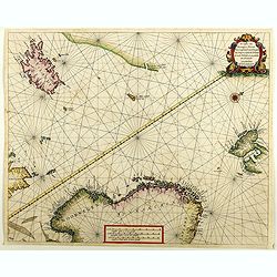
.Pascaerte Van't Westelyckste der Middelandsche Zee. . .
An eye-catching chart of the western part of the Mediterranean Sea.Pieter Goos (ca. 1616-1675) was one of the most important cartographer, engraver, publisher and print s...
Place & Date: Amsterdam, 1666
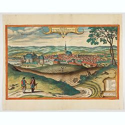
Polna vulgo Polm insign : Bohemia. . .
This is a view of Polna from the southwest looking across the Bohemian-Moravian Highlands from a slightly elevated viewpoint. In addition to the parish church (D) in the ...
Place & Date: Cologne, 1617

Pascaart van de west cust van Engeland en Wales Van S. Davids Point tot de Moul van Dalway.
Rare Doncker's sea chart of the Irish Sea with the west Coast of England (Liverpool), the Island of Man and the western-most tip of Northern Ireland (Bangor) and Souther...
Place & Date: Amsterdam, 1660-1668
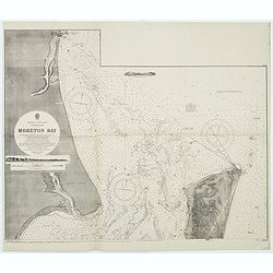
Australia, E. coast - Queensland Moreton Bay
Large chart representing East coast of Australia with Moreton Bay in Queensland.After a survey by Comr. J.Jeffery, etc. in 1865. New edition at the Admiralty 1870. With ...
Place & Date: London, 1882-1945
![{Title page] Introduction a la geographie, Contenant.. (2 sheets)](/uploads/cache/21495-250x250.jpg)
{Title page] Introduction a la geographie, Contenant.. (2 sheets)
In lower part title page an interesting world map in double hemisphere. The map is printed north up and is mirror imaged. Showing California as an island. French text on ...
Place & Date: Amsterdam, c. 1745

Abrahamus Ortelius Antuerpianus cosmographus natus a. MDXXVII
Portrait of Abraham Ortelius (Abraham Ortel), famous cartographer born in Antwerp and after studying Greek, Latin and mathematics set up business there with his sister, a...
Place & Date: Antwerp, c.1650
![[In Arabic, translates : A map of the United States of America shows its major regional ressources and its natural products]](/uploads/cache/43010-250x250.jpg)
[In Arabic, translates : A map of the United States of America shows its major regional ressources and its natural products]
Chromolithographed pictorial poster of the United States in Arabic language. Showing the United States' main products, regional resources and physical features. The map i...
Place & Date: Washington D.C., ca. 1965
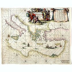
Orientalior districtus Maris Mediterranei.
Beautiful chart of the eastern part of the Mediterranean. Including Italy, the north coast of Africa and part of the Black Sea.The entire sheet is covered with rhumb line...
Place & Date: Amsterdam, 1675
![[Title page] Table Des Cartes etc: Du Sr. Sanson.](/uploads/cache/09204-250x250.jpg)
[Title page] Table Des Cartes etc: Du Sr. Sanson.
Large, powerfully engraved title page. Geographic scholars at work in a library are depicted along the bottom.Read more about title page [+]
Place & Date: Amsterdam, 1700
![[Title page] Nouveau Theatre Du Mond ou Nouvel Atlas . . .](/uploads/cache/43280-250x250.jpg)
[Title page] Nouveau Theatre Du Mond ou Nouvel Atlas . . .
The title page from Joahannes Janssonius / Hondius's Atlas Novus. Marvelous 18 coat of arms, armillary sphere, celestial and terrestrial globes and beautifully engraved f...
Place & Date: Amsterdam, 1638
![[Title page] Le nouveau et curieux Atlas Géographique et historique ou Le Divertissement des Empereurs, Roys, et Princes. Tant dans laz Guerre que dans la Paix.](/uploads/cache/17244-250x250.jpg)
[Title page] Le nouveau et curieux Atlas Géographique et historique ou Le Divertissement des Empereurs, Roys, et Princes. Tant dans laz Guerre que dans la Paix.
Decorative title page. According to its title, this atlas was intended for the entertainment of emperors, kings, and princes!
Place & Date: Paris, 1719
De custen van Noorwegen, Finmarcken, Laplandt, Spitsbergen . . .
Two sea charts on one sheet showing Norway, Finland, Iceland, Spitsbergen and part of Scotland. The chart includes a detailed plan of the coastlines, soundings, anchorage...
Place & Date: Amsterdam, 1666
![[Title page] Atlantis Novi Pars Secunda, exhibens Germaniam inferiorem, Galliam, Helvetiam, atque Hispaniam.](/uploads/cache/43277-250x250.jpg)
[Title page] Atlantis Novi Pars Secunda, exhibens Germaniam inferiorem, Galliam, Helvetiam, atque Hispaniam.
Highly decorative, and finely engraved architectural façade with figures topped with an armillary sphere.. The title is printed on a paste-on slip. Some elements highlig...
Place & Date: Amsterdam, 1638
![[Title page] Germaniae Tabule Geographicae ...](/uploads/cache/43267-250x250.jpg)
[Title page] Germaniae Tabule Geographicae ...
This is the title page to the volume of the atlas devoted to maps of Germany. According to Shirley the "early sectional parts of his "Atlas" each had Manne...
Place & Date: Amsterdam, 1585-c.1610
![[Title page] France divisée en 83 departements. [with title in manuscript].](/uploads/cache/39099-250x250.jpg)
[Title page] France divisée en 83 departements. [with title in manuscript].
Title page with in panel manuscript title in brown ink "France divisée en 83 departements. . .". On verso a manuscript compass rose. Title page engraved by P. ...
Place & Date: Paris, ca. 1790
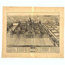
Scenographia Totius Fabricae S. Lau Renti Escoriali.
A wonderful west-looking bird's-eye view of the elaborate 16th century royal palace of San Lorenzo de El Escorial, a vast and elaborate complex commissioned by Philip II ...
Place & Date: Cologne, 1617
![[Map of the Holy Land, Israel, and Palestine.]](/uploads/cache/43037-250x250.jpg)
[Map of the Holy Land, Israel, and Palestine.]
A fine example of the six sheet map by Georgius Hornius map of the Holy Land. Each of the maps is embellished with countless vignettes and other images drawn from Biblica...
Place & Date: Amsterdam, Janssonius, 1662
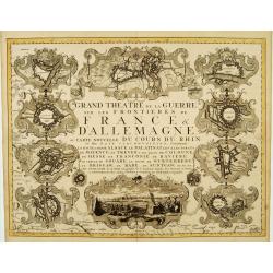
Grand Theatre de la Guerre sur les Frontieres de France & D'Allemagne..
Elegant arrangement of ten vignette views representing fortresses on or near the Rhine, including one view of a French Siège de Philipsbourg. The forts on the Rhine cons...
Place & Date: Amsterdam, c. 1745
Carte de la Mer Noire. (5e Feuille). Du Cap Zefiros au Cap Kerempeh. . .
Very detailed chart of the Turkish part of the Black Sea including the towns of Sinop, Samsun, etc. Showing soundings in meters, lighthouses are marked with yellow and re...
- $200 / ≈ €187
Place & Date: Paris, 1860
Christianus Henricus Heineken . . .
Portrait of Carl Heinrich, Baron von Heineken, as a child, whole-length, standing on a room with books on the right, a skeleton, and a large globe on the left, wearing a ...
- $300 / ≈ €281
Place & Date: Nuremberg, 1724-1748
![[Title page] Libellus Novus Politicus.. Pars Octava.](/uploads/cache/38483-250x250.jpg)
[Title page] Libellus Novus Politicus.. Pars Octava.
Very skilfully engraved title page from a rare work printed by Eberhard Kieser: Thesaurus Philo-Politicus. Das ist Politisches Schatzkästlein guter Herren und bestendige...
- $90 / ≈ €84
Place & Date: Frankfurt, 1626
![[Title page] Libellus Novus Politicus.. Pars Quinta.](/uploads/cache/38479-250x250.jpg)
[Title page] Libellus Novus Politicus.. Pars Quinta.
Very skilfully engraved title page from a rare work printed by Eberhard Kieser: Thesaurus Philo-Politicus. Das ist Politisches Schatzkästlein guter Herren und bestendige...
- $90 / ≈ €84
Place & Date: Frankfurt, 1626
![[Title page] Libellus Novus Politicus.. Pars Sexta.](/uploads/cache/38478-250x250.jpg)
[Title page] Libellus Novus Politicus.. Pars Sexta.
Very skilfully engraved title page from a rare work printed by Eberhard Kieser: Thesaurus Philo-Politicus. Das ist Politisches Schatzkästlein guter Herren und bestendige...
- $90 / ≈ €84
Place & Date: Frankfurt, 1626

Géographie des Plantes Equinoxiales - Tableau physique des Andes et pays voisins. . .
Physical Portrait of the Andes and adjacent lands", organized around the Chimborazo and Cotopaxi volcanoes in Ecuador.With local vegetation is illustrated pictoriall...
- $1000 / ≈ €936
Place & Date: Paris, 1805
Nieuwe Paskaert van de Kust van HOLLANDT - Tussen Texel en de Maes.
Nieuwe Paskaert van de Kust van Hollandt Tussen Texel en de Maes. A very attractive sea chart off the coast of Holland by Johannes van Keulen with a pair of decorative c...
- $500 / ≈ €468
Place & Date: Amsterdam, ca 1685
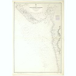
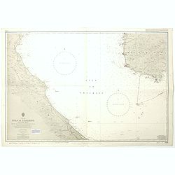
India west coast Gulf of Cutch to Vijaydurg . . .
Chart of India's west coast map surveyed by the hydrographer Captain JF Parry. A highly corrected version of Admiralty chart 2736 originally published 1st July 1915. Date...
- $200 / ≈ €187
Place & Date: London, 1915-1980

Pascaerte van 't Westelyckste Deel van Oost Indien, van Cabo de Bona Esperanca tot C.Comorin..
An eye-catching chart of the western part of the Indian Ocean and its adjacent coasts of East Africa, Arabia with the Red Sea and the Arabian Gulf, Iran, Pakistan and we...
Place & Date: Amsterdam, 1666
Carte de L'Entrée de la Mer Rouge. Dressée par M.Daussy. . .
Very large and detailed chart depicting the entrance of the Red Sea, including the coastline of Yemen with inset "Carte du détroit de Bab!el-Mandeb. . ." and &...
- $750 / ≈ €702
Place & Date: Paris, ca. 1840
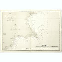
Cyprus south east coast Cape Kiti to Cape Eloea.
An British Admiralty chart of Cyprus south east coast. A highly corrected version of Admiralty chart 971 originally published 15th February 1866 under the Superintendence...
- $100 / ≈ €94
Place & Date: London, 1852
Nova Helvetiae tabula geographica . . .
Johann Jakob Scheuchzer (August 2, 1672 – June 23, 1733) was a Swiss scholar born at Zürich. In 1712 he published, a map of Switzerland in four sheets (scale 1/290,000...
- $1750 / ≈ €1638
Place & Date: Amsterdam, 1712
![[Title page] Theatri Europaei, oder Beschreibung . . .](/uploads/cache/41395-250x250.jpg)
[Title page] Theatri Europaei, oder Beschreibung . . .
Title page.
- $80 / ≈ €75
Place & Date: Frankfurt, Johann Görlin, 1679

Anamu Buru to Latakia including Iskenderun Körfezi.
A highly corrected version of Admiralty chart 2632 originally published 25 November 1955 under the Superintendence of Captain K.SB. Collins. Edition Date 1984 Detailed ch...
- $100 / ≈ €94
Place & Date: London, 1955 - 1984
China sea Gulf of Tongking (Southern sheet).
A highly corrected version of Admiralty chart 3989 originally published 11 Mai 1962 under the Superintendence of Captain EG Irving. Detailed chart including the coasts of...
- $80 / ≈ €75
Place & Date: London, 1962 - 1992

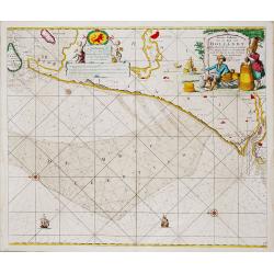
Pas-Caart van de ZUYDER-ZEE, Texel ende Vlie-stroom.als mede 't Amelander gat (Hollandt/Vrieslandt)
An attractive chart of the Zuiderzee, now the inland water het IJselmeer.HOLLANDT / VRIESLANDTPas-Caart van de Zuyder-Zee, Texel ende Vlie-stroom.als mede 't Amelander g...
- $1200 / ≈ €1123
Place & Date: Amsterdam, c. 1665
![[Untitled map of the European countries in a playing grid].](/uploads/cache/38469-250x250.jpg)
[Untitled map of the European countries in a playing grid].
Small, accurate lithographed map of Europe, embedded in a square playing grid formed by 100 cells.The 11 cells contain the profile of or a reference to Emperors, some cel...
- $100 / ≈ €94
Place & Date: France, ca. 1850
![[Untitled map of the European countries in a playing grid].](/uploads/cache/38468-250x250.jpg)
[Untitled map of the European countries in a playing grid].
Small, accurate lithographed maps of Europe, embedded in a square playing grid formed by 100 cells.The 11 cells contain the profile or a reference to an Emperors, some ce...
- $100 / ≈ €94
Place & Date: France, ca. 1850
![[Title page] Thesauri Philo Politici pars Prima ...](/uploads/cache/38450-250x250.jpg)
[Title page] Thesauri Philo Politici pars Prima ...
Very skillfully engraved title page from a rare work printed by Eberhard Kieser: "Thesaurus Philo-Politicus. Das ist Politisches Schatzkästlein guter Herren und bes...
- $80 / ≈ €75
Place & Date: Frankfurt, 1630
![[Title page] Libellus Novus Politicus.. Pars Quinta.](/uploads/cache/38475-250x250.jpg)
[Title page] Libellus Novus Politicus.. Pars Quinta.
Very skilfully engraved title page from a rare work printed by Eberhard Kieser: Thesaurus Philo-Politicus. Das ist Politisches Schatzkästlein guter Herren und bestendige...
- $80 / ≈ €75
Place & Date: Frankfurt, 1700

A chart of the northern part of the Indian Ocean..
Chart of the northern part of the Indian Ocean, including part of Arabia, India and Sri Lanka prepared by D'Apré de Mannevillette and published in London by Laurie and W...
- $750 / ≈ €702
Place & Date: London 1794
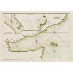
Carte de l'Entrée du Golf de la Mer Rouge. / Plan de La Rade de Moka.
French sea chart of the entry of the Red Sea showing both the African and Arabian coasts. With two inset charts: Plan de La Rade de Moka. and one with the coasts south of...
- $450 / ≈ €421
Place & Date: Paris, ca 1775
![[Titlepage] Atlas Homannianus Mathematico Historice delineatus.](/uploads/cache/36600-250x250.jpg)
[Titlepage] Atlas Homannianus Mathematico Historice delineatus.
Title page with In the foreground the female figures of Geography, History and Astronomy stand before a large globe, showing the Eastern Hemisphere. Above them the atlas ...
- $350 / ≈ €328
Place & Date: Nuremberg, 1762

Kronstat From The Russian Survey . . .
Scarce chart of the Island of Kronstat, the primary defensive position for the Russian Navy in defense of Russia's Czarist Capital of St. Petersburg.Published on the eve ...
- $500 / ≈ €468
Place & Date: London, 1853

Eastern passage to China. sheet 1.
James Horsburgh early chart of the coasts of Java, Bali, Lombok, with part of Sulawesi, and Borneo. Insets of "Sketch of Bally Strait", Sketch of Lombock Strait...
- $2500 / ≈ €2339
Place & Date: London, 1824
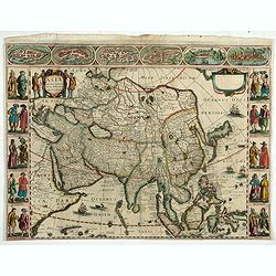
Asia recens Summa cura delineata.
Rare map of Asia published in Pierre d'Avity's "Les Estats Empires, Royaumes, Et Principautez Du Monde". Derivative map of Hondius' rare separately issued map o...
- $3000 / ≈ €2807
Place & Date: Paris, ca. 1659
Spectandum dedit Ortelius mortalib..
This famous portrait, engraved by Galle, was included in Ortelius' atlases from 1579 onwards.The title translation is By looking, Ortelius gave to mortal beings the world...
- $550 / ≈ €515
Place & Date: Antwerp, 1580
![[Title page] Thesauri Philo-Politci Quarta pars. . .](/uploads/cache/38447-250x250.jpg)
[Title page] Thesauri Philo-Politci Quarta pars. . .
Very skillfully engraved title page from a rare work printed by Eberhard Kieser: Thesaurus Philo-Politicus. Das ist Politisches Schatzkästlein guter Herren und bestendig...
- $90 / ≈ €84
Place & Date: Frankfurt, 1624
![[Title page] Thesauri Philo-Politci pars Secunda. . .](/uploads/cache/38448-250x250.jpg)
[Title page] Thesauri Philo-Politci pars Secunda. . .
Very skillfully engraved title page from a rare work printed by Eberhard Kieser: Thesaurus Philo-Politicus. Das ist Politisches Schatzkästlein guter Herren und bestendig...
- $75 / ≈ €70
Place & Date: Frankfurt, 1624
![[Double celestial and terrestrial hemisphere]](/uploads/cache/44995-250x250.jpg)
[Double celestial and terrestrial hemisphere]
Small but uncommon double celestial and terrestrial hemisphere. The terrestrial map showing the western hemisphere with an oversized an curious Australian continent.
- $300 / ≈ €281
Place & Date: ca. 1750
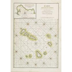
Carte des Iles du Cap-Verd Dressée sur les remarques et les observations les plus exactes des Navigateurs.
French sea chart of the Cap Verde Islands, situated 570 kilometers off the coast of Western Africa.Latitude and longitude scales, compass rose and system of rhumb lines, ...
- $100 / ≈ €94
Place & Date: Paris, Brest, chez Demonville, 1775
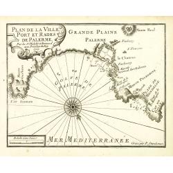
Plan de la Ville, Port et rades de Palerme. . .
An attractive chart centered on Palermo. With scale and large compass-rose. Dated 1727, with the privilege of the King. From : Recueil des Plusieurs plans des ports et ra...
- $250 / ≈ €234
Place & Date: Marseille, 1730
![Hoo Daihiko Kinen Hiko Sugoroku [ [訪欧大飛行記念飛行双六 ]](/uploads/cache/46569-250x250.jpg)
Hoo Daihiko Kinen Hiko Sugoroku [ [訪欧大飛行記念飛行双六 ]
FIRST EDITION. A rare paper board game celebrating a flight from Tokyo to Rome Europe. Published in by Osaka Asahi Shinbun.This color offset-printed sugoroku (a paper “...
- $600 / ≈ €561
Place & Date: Osaka, Taisho 14 or 1925
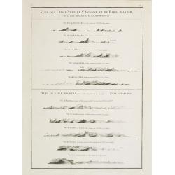
Vues des Cap d'Aden, de St. Antoine, et de Bab-El-Mandeb, sur la Côte Méridionale de l'Arabie Heureuse. Vues de l'Isle de Socotra
Coast profiles near Cape Aden in Yemen and in the lower part coastal profiles near Socotra, an island east of the Horn of Africa and 380 kilometers (240 mi) south of the ...
- $250 / ≈ €234
Place & Date: Paris, Brest, chez Demonville, 1775