Browse Listings in Europe > Netherlands
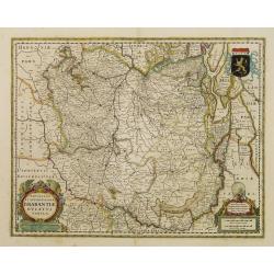
Novissima et Accuratissima Brabantiae Ducatus Tabula.
North is to the right. Like all other maps of Brabantiae Ducatus, it encloses the area between the rivers Rhine, Maas and Schelde, with Namur as the most southern town. O...
- $350 / ≈ €328
Place & Date: Amsterdam, 1629
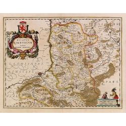
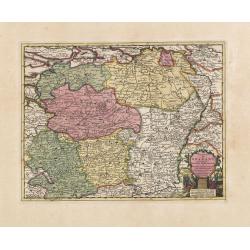
Ducatus Limburg.
In 1616 prepared by Aegidio Martini. Includes the towns of Maastricht as well as of Aachen. A very large title cartouche with two putti.
Place & Date: Amsterdam 1639

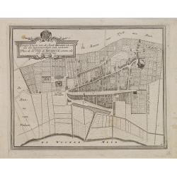
DELFT. Delphium urbs Hollandiae cultissima. . .
A bird's-eye view of the town of Delft. From the first Dutch translation of Guicciardini's description of the Netherlands. In this town-plan, three buildings, still domin...
Place & Date: Amsterdam, 1612
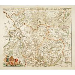
Transisalania provincia vulgo Over-Yssel auctore N.ten Have
Detailed map prepared by Nico ten Have.
Place & Date: Amsterdam, 1690

Vue de Gattweick et de l'embouchure du Rhin, dans la Mer du Nord.
Very decorative view of Katwijk. Signed lower right, Louis Bleuler au chateau de Laufen . Original design by Louis Bleuer. This gouache was the model for his aquatint in ...
Place & Date: 1820

Tabula Ducatus Brabantiae.
Detailed map orientated west to the top.
Place & Date: Amsterdam, 1680

Tabula ducatus Limburch et comitatus Valckenburch. . .
The map describes the southern part of Limburg and reaches into Belgium (Liege, Verviers) and Germany. With two very decorative cartouches.
Place & Date: Amsterdam, 1690
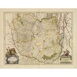
Brabantia Ducatus.
West is at the top. On the lower left a magnificent cartouche with a sitting female figure carrying a globe and compasses and the coat of arms of Brabant. Like all other ...
- $500 / ≈ €468
Place & Date: Amsterdam, 1650

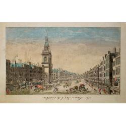
Beschrijving Gezicht van den Ykant af bezyden den Schreiers hoex Toren langs de Keulsche en Geldersche Kaei naer de Nieuwe Markt
This large engraving (560x920mm.) comes from a are series of 25 beautiful large views of Amsterdam and gives a colorful picture of the life and business of the city at th...
Place & Date: Amsterdam, ca. 1720

Currus Veliferi Illmi. Pr. Mauritii Nassouvii. (Prince Maurits' sailing-carriage, designed by Simon Stevin. )
Prince Maurits' sailing carriages had been designed by Simon Stevin. The Prince, always accessible to new inventions of his old instructor, could not please the foreign a...
Place & Date: Amsterdam, 1649

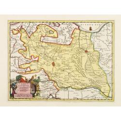
Fossa Sanctae Mariae.
Detailed map of part of the country between rivers Rhine and Meuse showing a canal to be dug between 1626 and 1628 between Rheinberg in Germany and Venlo. A deficiency of...
Place & Date: Amsterdam, 1645

Tabula Bergarum ad Zomam Stenbergae et novorum ibi operum.
The map gives an outline of the Scheldt from Bergen op Zoom to Antwerp, with all the ramparts built between 1622 and 1627.
Place & Date: Amsterdam, 1647

De Texel Stroom .. vant Marsdiep./ Caarte van De Mase...
Two decorative charts on one sheet, one depicting Texel and the entrance of the Zuider Zee with an inset showing the north coast of West-Friesland, the other depicting th...
- $750 / ≈ €702
Place & Date: Amsterdam, 1660
Gemete Kaerte van de Stede Beverwyk, zoo als die tegenwoordigh zich vertoont.
Uncommon plan of Beverwijk made in the year 1739. Published in Hollandsche Arcadia. Title in Dutch and French.
- $75 / ≈ €70
Place & Date: Amsterdam, ca.1740
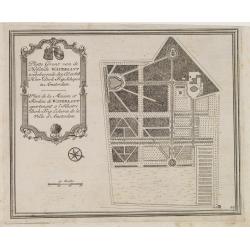
Platte Gront van de Hofstede Waterlant toebehorende den Ed. Achtb. Heer Dirk Trip Schepen te Amsterdam.
Uncommon plan of Hofstede Waterlant. Published in Hollandsche Arcadia. Title in Dutch and French "Plan de la Maison et Jardins appartenant a l'Illustre Dirk Trip Ech...
- $40 / ≈ €37
Place & Date: Amsterdam, 1740

De Tesselstroom met de Gaten van Marsdiep./ De Mase met. . .
Three charts on one sheet depicting the entrances to the Zuiderzee between Holland, Texel and Vlieland. The entrances of the Maas with Rotterdam and in a small inset the ...
- $500 / ≈ €468
Place & Date: Amsterdam, 1662

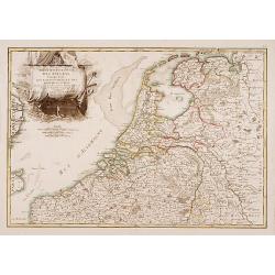
Tabula comitatus Hollandiae. . .
Fine map of the provinces of North and South Holland. In upper left hand corner an inset with the islands of Texel and Vlieland.
Place & Date: Augsburg 1760

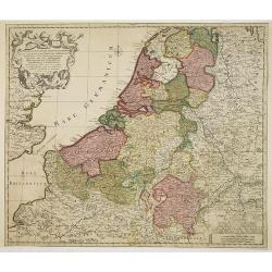
Belgium Foederatum emendate auctum et novissimé editum.
Fine detailed map of the area of the modern Netherlands less the southern part of Limburg. Title cartouche representing the commerce, the arts and the sciences. The Lion ...
Place & Date: Amsterdam, 1680

Les Provinces confederées du Pais-Bas
The first wall map of the Seven Provinces of 1651, re-issued as 'Stoel des Oorlogs' by Covens & Mortier. The first issue of the present wall-map is known to be includ...
Place & Date: Amsterdam, c. 1740

Slusa, Teutonicae Flandriae opp. . . (Sluis)
Bird'eye view of the town of Sluis.From the greatest publication in this genre!. The Civitates was compiled and written by George Braun, Canon of Cologne Cathedral. Braun...
Place & Date: Cologne, 1580

Vue du Magazin de la Compagnie des Indes Orientales. . .
So-called optical print of the formerly the V.O.C. warehouse and arsenal for the Admiralty of Amsterdam, now-a-days the Scheepvaartmuseum (Maritime Museum).In the eightee...
Place & Date: France, 1780
Septendecm. Provinciae Germaniae Inferior. . .
A general map of the Netherlands, Luxembourg and Belgium. Fine title cartouche showing Mercury, Neptune, globe, etc. Lower right coat of arms of 17 Provinces.
- $225 / ≈ €211
Place & Date: Amsterdam, 1700
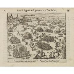
Auriaco infaelix Roermonda. . .
Showing the siege in May 1572 of Roermond.
- $100 / ≈ €94
Place & Date: Amsterdam, 1612
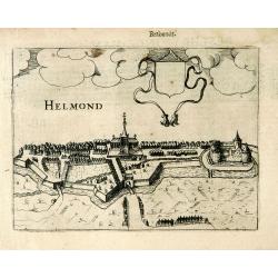
Helmond.
A panoramic view of the Helmond, seen from the Kromme Steenweg .
Place & Date: Arnhem, 1613

Kaart van Zeeland.
Fine map of the province of Zeeland, with the fortified cities are highlighted in red. Isaac Tirion was born in Utrecht ca. 1705. He came to Amsterdam ca. 1725. Tirion pu...
Place & Date: Amsterdam, 1747
Partie Septentrionale des Pays Bas..
"Detailed map covering the Low Countries, published by Jean Latré."
- $400 / ≈ €374
Place & Date: Paris 1760

Nieuwe kaart van het oostelykste deel van Holland. . .
Detailed map covering the area of Gouda, Iisselstein, s'Hertogenbosch, Zevenbergen, Dordrecht.
Place & Date: Amsterdam, 1749
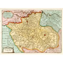
La Mayerie de BOLDVC,. . .
From his atlas Oorlogs tablessen, Oft uytgesochte Kaarten . Covering the so-called area Meierij van 's-Hertogenbosch . Eindhoven in the centre of the map.
- $150 / ≈ €140
Place & Date: Amsterdam, 1706
L'Utrecht. . .
Although not renowned for the originality of his work, Pieter van der Aa is highly thought of for the design and quality of his output. Showing Dutch province of Utrecht....
Place & Date: Amsterdam, 1713
Carte du Brabant, suivant les Nouvelles Observations de Messrs de L'Academie Royale des Sciences etc. . .
Although not renowned for the originality of his work, Pieter van der Aa is highly thought of for the design and quality of his output. Showing the present-day Dutch and ...
- $300 / ≈ €281
Place & Date: Amsterdam, 1713
De Maria kerk te Leiden.
In the eighteenth and nineteenth centuries, there were many popular speciality establishments in Paris, Augsburg and London that produced optical viewing devices and spec...
- $200 / ≈ €187
Place & Date: Paris, 1760

Hollandia Comitatus.
Orientated west to the top of the sheet, this presents the County of Holland in the classical orientation for seventeenth-century maps, with Amsterdam at the center. The ...
Place & Date: Amsterdam, 1660

Das Hertzogthum Braband. . .
Charming map of the Dutch and Belgium province of Brabant. With a fine cartouche.
Place & Date: Leipzig, 1749

Die Republic Holland oder die Verenigte Niederlande..
Charming map of the Netherlands, with inset maps of Novi Belgium area in America and Indonesia. With a fine cartouche.
- $250 / ≈ €234
Place & Date: Leipzig 1749
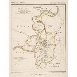
Gemeente Roermond.
From: J.Kuyper Gemeente-Atlas van Nederland naar officieele bronnen bewerkt. He was one of the most important of the Dutch atlas editors of the second half of the 19th ce...
- $90 / ≈ €84
Place & Date: Leeuwarden 1867

Provincie Noord-Braband.
Decorative and uncommon costume plate lithographed by Desguerrois & Co. and published by Frans Buffa & Zonen in Amsterdam. 12 illustrations of Brabant costumes: 1...
Place & Date: Amsterdam, 1857

Provincie Noord-Braband. / Breda, de Langstraat. . .
Decorative and uncommon custume plate lithographed by R. de Vries and published by Frans Buffa & Zonen in Amsterdam. A group of 4 women from the area of Baronie van B...
Place & Date: Amsterdam, 1857

Prospectus Castelli Boxtel.
One of the earliest views of the Castle of Boxtel. Engraved by Henricus Cause. With a description in Latin, French and Dutch.
Place & Date: Amsterdam, 1695

Prospectus veteris castelli Graviae.
One of the earliest views of the ancient Castle of Grave. Engraved by Casper Bouttats. With a description in Latin, French and Dutch.
Place & Date: Amsterdam, 1695
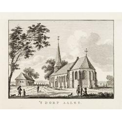
't dorp Aalst.
Rare print of the old church of Aalst (near Eindhoven), from Vaderlandsche gezichten of afbeeldingen.. by J.Bulthuis, printed by H.Gartman in Amsterdam.
- $100 / ≈ €94
Place & Date: Amsterdam 1786-1792