Browse Listings in Europe > Netherlands

Kaerte en Afbeeldinge vande Geheele Jurisdictie van Stantdarbuyten Gelegen in de Generaliteit onder Marquisaet van Bergen op den Zoom
With a large title cartouche with signature of the maker Adriaan van der Ende, : Kaerte en Afbeeldinge vande Geheele Jurisdictie van Stantdarbuyten Gelegen in de Generali...
Place & Date: Willemstad, 1737
![Theatrum praecipuarum urbium Ducatus Brabantiae. / bound with : [Hogenbergs Geschichtsblätter].](/uploads/cache/48788-250x250.jpg)
Theatrum praecipuarum urbium Ducatus Brabantiae. / bound with : [Hogenbergs Geschichtsblätter].
Volume including two series :1st series : [Schut, Pieter Hendricksz]. Theatrum praecipuarum urbium Ducatus Brabantiae… Illustrated with an engraved title page and 43 pl...
Place & Date: (Amsterdam), N. Visscher, 1657 / Cologne, 1566-1579
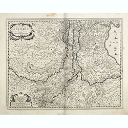
Ducatus Geldriae novissima. . .
Early map of Gelderland, but also including Utrecht, and parts of Brabant. Shows many cities (like Nijmegen, Eindhoven, Zutphen, Zwolle, etc), roads, rivers, woods, regio...
- $350 / ≈ €328
Place & Date: Amsterdam, 1629-1630

Episcop. Ultraiectinus.
A very detailed map based on Utrecht. Scale cartouche held by a surveyor. Based on the map by B.F.van Berckenrode (1620-21) and engraved by the master engraver Evert Sijm...
Place & Date: Amsterdam, 1630-1632
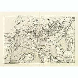
Pas-Caert vande ghelegetheyt vande Schans te Santvliet, Vertoonede de verdroncken overwaeterde Landen, nieuw aengewasse gorsingen,. . .
Showing the surrounding countryside of the cities of Antwerp, Santvliet, Lillo, Bergen op zoom, etc. The map is ponctuated by several fortifications to indicate the main ...
- $400 / ≈ €374
Place & Date: Amsterdam, 1630

Kaerte van Bergen op Zoom, Steenbergen ende de nieuwe fortificatien gemaeckt tot bevrÿdinge van 't landt van ter Tolen in tjaar 1628.
Very detailed and scarce map showing Bergen Op Zoom, Steenbergen and its surrounding countryside. North to the left side.
- $400 / ≈ €374
Place & Date: Amsterdam, after 1628

Belgica Foederata. . .
Decorated with a cartouche showing the coats of arms of Zeeland, Holland, Utrecht, Friesland, Groningen and Overijssel. T.C. Lotter married M. Seutter's daughter in 1740 ...
Place & Date: Augsburg, ca.1760
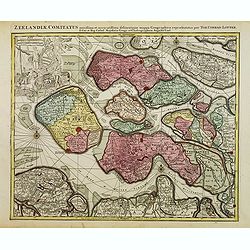
Zeelandiae Comitatus. . .
Scarce map of Zeeland, this is the state published by Tobias Conrad Lotter, previously published by Matthäus Seutter.Impressive cartouche with coat of arms of Zeeland to...
- $400 / ≈ €374
Place & Date: Augsburg, c.1760
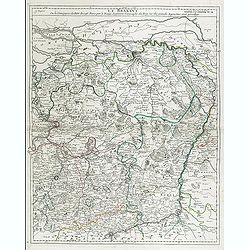
Le Brabant. Ou la Campagne du Roy de 1746. . .
Uncommon map of Dutch and Belgium Brabant by George Louis Le Rouge, who was active from 1740- till 1780 as a publisher and was appointed engineer for the King of France.D...
- $300 / ≈ €281
Place & Date: Paris, ca. 1750
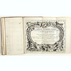
Comté d'Hollande, seigneurie d'Utrecht, comtés de Zelande, de Zutphen et duché de Brabant &c. Dressés sur les Mémoires faits par ordre des Estats Généraux et augmentés sur les Observations nouvelles.
Pocket atlas illustrated with a folded engraved title, a general map and 34 folded maps, including maps of the Netherlands, Belgium and parts of Germany.Provenance : Ex-l...
- $2400 / ≈ €2246
Place & Date: Paris, Crépy, ca. 1748

Pas-Caart van de ZUYDER-ZEE, Texel ende Vlie-stroom.als mede 't Amelander gat (Hollandt/Vrieslandt)
An attractive chart of the Zuiderzee, now the inland water het IJselmeer.HOLLANDT / VRIESLANDTPas-Caart van de Zuyder-Zee, Texel ende Vlie-stroom.als mede 't Amelander g...
- $1200 / ≈ €1123
Place & Date: Amsterdam, c. 1665