Browse Listings in Europe > Eastern Europe

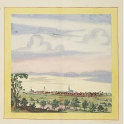
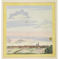
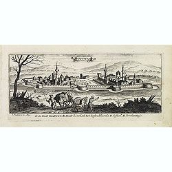
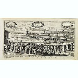
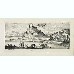
Launa vulgo Laun Bohemiae civitas.
Bird's-eye views of Louny in Bohemia by G. Hoefnagel. The copperplate was made for Braun and Hogenberg's town book. However there the print has been transformed by the en...
Place & Date: The Hague, 1700
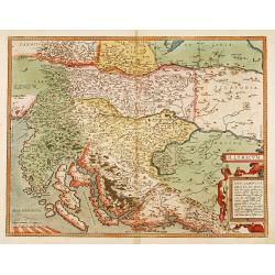
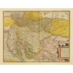
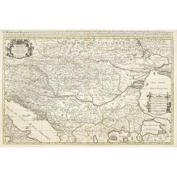
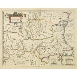
Illyricum.
Early map of Istria and Slovenia. Prepared by Johann Sambucus 1572.
Place & Date: Antwerp, 1574
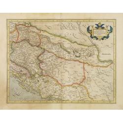
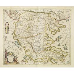
Sclavonia, Croatia, Bosnia cum Dalmatiae parte.
Nice map of the Eastern Balkans with the political divisions of Slovenia, Croatia, Bosnia and Dalmatia.Mercator was born in Rupelmonde in Flanders and studied in Louvain ...
- $300 / ≈ €281
Place & Date: Amsterdam 1630
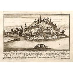
Belgrad / Biograd.
A very RARE panoramic view of the city of Belgrade, including a numbered legend in the lower part.Published by the brothers Chéreau, active in Paris at rue st.Jacques au...
Place & Date: Paris, c.1720
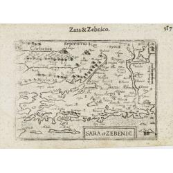
Sara et Zebenic.
A miniature map of the islands of Dalmatia. Title cartouche on the lower left side.First published in 1598 in his Caert-Thresoor, the plates were executed by the most fam...
- $100 / ≈ €94
Place & Date: Amsterdam / Frankfurt, 1609
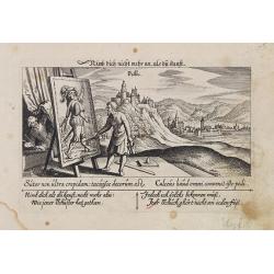
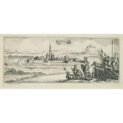
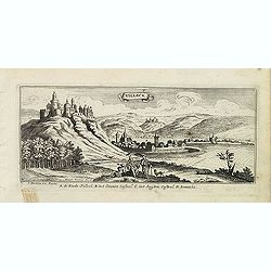
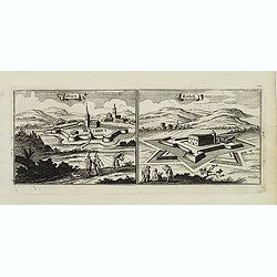
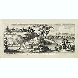
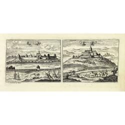
Villec.
A very nice view the town of Villeck in Czechoslovakia. On the foreground, a man examining a painting is depicted. With a verse in two languages underneath the picture.Th...
- $75 / ≈ €70
Place & Date: Frankfurt, 1623-1678
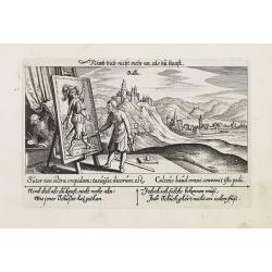
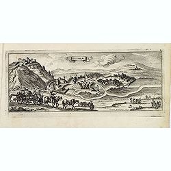
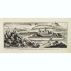
Villec.
A very nice view of Villec in Hungary (Fülek, Filakovo). In background a castle and in the foreground, a man examining a painting. With a verse in two languages undernea...
- $90 / ≈ €84
Place & Date: Frankfurt, 1623-1678
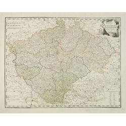
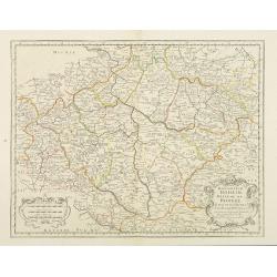
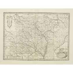
Karte von dem Konigreiche Boheim.
An attractive map of Bohemia. With a nice title cartouche decorated with cherubs in the upper right-hand corner. Engraved by Kil. Ponheimer.Franz Johann Josef von Reilly ...
- $300 / ≈ €281
Place & Date: Vienna, 1796
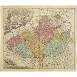
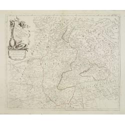
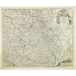
Tabula Generalis Marchionatus Moraviae..
Johann Baptist Homann's well-engraved map has a large decorative cartouche. Detailed map of the historic Moravia region of the Czech Republic, in the present-day Jihormor...
- $275 / ≈ €257
Place & Date: Nuremberg 1744
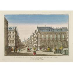
Vue perspective de la Place des Peintres ditte Perlach du cote de la Basse Ville a Prague.
A so-called optical print of a square in Prague by Basset, a well-known publisher of optical prints, was established in rue S.Jacques in Paris. With brief key list.In the...
- $300 / ≈ €281
Place & Date: Paris, 1760

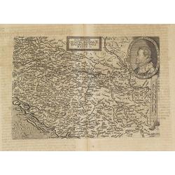
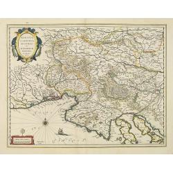
Carinthiae et Goritiae... / Histria tabula.../ Zarae, et Serebenici ..
Three maps on one sheet. The left hand is centered on the eastern part of Austria. The right upper hand map is centered on northern Yugoslavia, and the last map is center...
Place & Date: Antwerp, 1598
Illyricum.
Early map of Istria and Slovenia. Prepared by Johann Sambucus 1572.The map is in a strictly contemporary coloring.Read more about coloring.
- $600 / ≈ €561
Place & Date: Antwerp, 1574
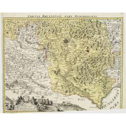
Circuli Brunnensis Pars Meridionalis.
Johann Baptist Homann's well-engraved and detailed map of the present-day South Moravia region centered on Brno, with decorative cartouche at the bottom.Johann Baptist Ho...
Place & Date: Nuremberg 1770 - 1774
Selling price: $250
Sold in 2008
![Mer Adriatique. Côte Orientale. De l'Ile Meleda à Antivari.. [3552]](/uploads/cache/23471-250x250.jpg)
Mer Adriatique. Côte Orientale. De l'Ile Meleda à Antivari.. [3552]
This large scale coastal chart shows the stretch of Dalmatian coast between the island Mljet in Croatia as far as Ulcinj (Montenegro). With latitude and longitude scales,...
- $200 / ≈ €187
Place & Date: Paris [1877] corrected to 1934
![Environs de Raguse (Dubrovnik). Deuxième Feuille. Canal de Calamota (Kolocep).. [277]](/uploads/cache/23473-250x250.jpg)
Environs de Raguse (Dubrovnik). Deuxième Feuille. Canal de Calamota (Kolocep).. [277]
This large-scale coastal chart shows the stretch of the Dalmatian coast between Slano as far as the island of Kolocep, the southernmost inhabited island in Croatia. With ...
- $200 / ≈ €187
Place & Date: Paris [1877] corrected to 1932
![Mer Adriatique. Partie Sud.. [3976]](/uploads/cache/23549-250x250.jpg)
Mer Adriatique. Partie Sud.. [3976]
This large scale coastal chart centered on the southern part of the Adriatic sea. Showing the Dalmatian coast between Split in Croatia as far as the northernmost tip of C...
- $200 / ≈ €187
Place & Date: Paris [1883] updated for 1935
Konigreich Boheim. Royaume de Boheme. . .
Covering Czech Republic and centered on Prague. Nicolas Sanson was to bring about the rise of French cartography, although the fierce competition of the Dutch would last ...
- $300 / ≈ €281
Place & Date: Paris, 1654
![[No title] Part of Eastern Europe, including Poland, the Czech Republic, Slovakia and Slovenia.](/uploads/cache/24266-250x250.jpg)
[No title] Part of Eastern Europe, including Poland, the Czech Republic, Slovakia and Slovenia.
Attractive map showing part of the course of the river Danube, from Germany to Hungary.Including Poland, the Czech Republic, Slovakia and Slovenia. Boundaries outlined in...
- $100 / ≈ €94
Place & Date: Paris, ca 1783

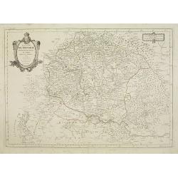
Royaume de Bohéme, Marquisat de Moravie, et Silésie Autrichenne.
Small detailed map of today Czech Republic. From Atlas Portatif Universel, by Robert de Vaugondy.Unrecorded state with erased date. Page 32 outside border top right. Mary...
Place & Date: Paris, later than 1749
Principauté de Transilvanie et Pays circonvoisins..
Detailed map encompassing part of present-day Hungary.From "Atlas Universel" published by Santini in 1784. The atlas is effectively an Italian copy of the Rober...
Place & Date: Venice, 1784
Royaume de Hongrie.
Detailed map encompassing present day Hungary with the river Danube and the towns of Belgrade, Budapest, Vienna, etc.Venetian edition of the map by Bellin, to whom Santin...
Place & Date: Venice, 1776 - 1784
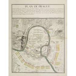
Plan de Prague.
Rare and separately published plan of Prague published by Joan Baptista Nolin with the address à l'enseigne de la Place des Victoires et chez le Sr. Humblot rue St. Jacq...
Place & Date: Paris, ca. 1742

Walachia Servia, Bulgaria, Romania.
The cartographer of this map was Gerard Mercator. This attractive map of the Eastern Balkans is centered on Bulgaria and includes the Bosphorus and Constantinople. The Da...
Place & Date: Oxford, 1680
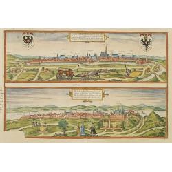
Vienna.. / Buda..
Pair of views on one sheet, the first showing the Austria capital of Vienna with fields, and figures in the foreground.Lower view shows the Hungarian capital of Budapest....
Place & Date: Cologne 1580
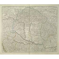
Carte Particuliere de la Hongrie de la Transilvanie de la Croatie et de la Sclavonie Dressée sur les Onservations de Mr. Le Comte Marsilli. . . Par G. Delisle.
Map of Hungary and Slovakia and adjacent parts of Croatia, Serbia and Romania (Transylvania). Prepared by Marsilli, published by Dezauche.
Place & Date: Paris, ca. 1780
![[Page with imaginary towns in Hungary. ] CCLXVIII](/uploads/cache/26932-250x250.jpg)
[Page with imaginary towns in Hungary. ] CCLXVIII
Page with imaginary towns in Hungary (230x225mm.) This leaf is from an edition of Hartmann Schedel's Liber chronicarum or Nuremberg Chronicle. The Chronicle was published...
Place & Date: Nuremberg, 1493
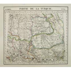
Europe. Partie de la Turquie. N°21.
Detailed map including Hungary and Romania.From his famous Atlas Universel . This atlas was one of the most remarkable world atlases ever produced, anticipating the Inter...
Place & Date: Brussels, 1825-1827
![Praghe. [ Prague ]](/uploads/cache/27801-250x250.jpg)
Praghe. [ Prague ]
A rare panoramic of Prague with over the whole length of the lower part 3 columns of poems in Dutch, French, German and English.Frederick de Wit published after 1694 a t...
- $2000 / ≈ €1871
Place & Date: Amsterdam, 1694
Sclavonia Croatia, Bosnia & Dalmatiae Pars Maior.
Mattheus Quadt's map of the western Balkan with a portrait of the Roma.Matthias Quadt (1557-1613) was a Dutch geographer who worked in Cologne. From "Geographisch ha...
- $600 / ≈ €561
Place & Date: Cologne, 1600
Le Royaume de Hongrie.
Fine oversized map of Hungary, but including Bosnia and Herzegovina, Bulgaria, Croatia, Romania, Albania, European part of Turkey, and Ukraine. With a decorative title an...
Place & Date: Amsterdam, 1692
![Praga. [Prague]](/uploads/cache/28442-250x250.jpg)
Praga. [Prague]
A rare panoramic of Prague with over the whole length of the lower part 3 columns of poems in Latin, Dutch and French and a numbered key 1-34 to the principal buildings ...
Place & Date: Amsterdam, 1660
Marchionatus Moraviae Auct I. Comenio.
Centered on Brno and Olomouc in south eastern part of Czech Republic.The cartographer of this map was Johan Amos Comenius (1592-1670), Czech cartographer and priest.Publi...
- $250 / ≈ €234
Place & Date: Oxford, 1682
![Le Cours du Danube. . .[2 maps].](/uploads/cache/28472-250x250.jpg)
Le Cours du Danube. . .[2 maps].
Detailed two-sheet map of the course of the River Danube from its source up to Vienna. Showing the cities, like Linz, Passau, Straubing, Regensburg, Ulm, Augsburg, Munich...
- $450 / ≈ €421
Place & Date: Paris, 1705
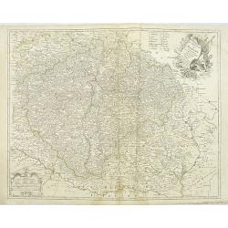
Regnum Bohemia.. Silesia.. Moravia, et Lusatia..
Detailed map of Czechoslovakia including the towns of Dresden, Prague, Breslau, etc. With fine title cartouche upper left, putti carrying the coats of arms of Bohemia, Mo...
- $400 / ≈ €374
Place & Date: Amsterdam, 1680
Regni Bohemiae, Duc. Silesiae, Marchionatuum Moraviae et Lusatiae. . .
Johann Baptist Homann's well-engraved map including the towns of Prague, Poznan/ Loda, Wroclaw, etc.This example was printed from plate A (1st of 3), which can be identif...
- $200 / ≈ €187
Place & Date: Nuremberg, ca. 1748
Le Royaume de Boheme. Carte reduite sur celle de 25 feuilles faite a Prague, par Müller, a Paris. Par et chez le sieur leRouge Ingr. Géographe du Roy . . .
Uncommon general map of the Czech Republic, centered on Prague. Prepared after the 25 sheet wall map of J.C. Müller, and published by Le Rouge. Folio maps by Le Rouge ar...
- $100 / ≈ €94
Place & Date: Paris, 1742

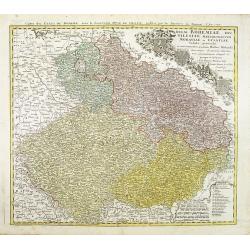
Le Royaume de Boheme, le Duché de Silesie, et les Marquisats de Moravie et Lusace, dresses d'apres les cartes de Muller . .
Map of Poland, Bohemia, Silesia, Moravia and Lusatia. Large decorative title cartouche in upper right. In upper left corner inset plan of Breslau and in lower right a ins...
Place & Date: Paris, 1790

Danubius Fluvius Europae Maximus, a Fontibus ad Ostia..
Depicts the course of the Danube River, from its sources in the Alps to the Black Sea..Because of the dimensions the map was printed from two copper plates.With two very ...
Place & Date: Amsterdam, 1638
Walachia, Servia, Bulgaria, Romania.
Striking map of the region centered on the Lower Danube, Bulgaria, Romania, Serbia and Macedonia. Includes decorative cartouche, coat of arms, etc. Latin text on verso.Th...
Place & Date: Amsterdam, 1638
Karstia, Camiola, Histria et Windorum Marchia.
Including the Gulf of Trieste, Venice and the northern part of former Yugoslavia. Prepared by Gerard Mercator.As Willem Blaeu died in 1638 most of his maps are actually p...
Place & Date: Amsterdam, 1638
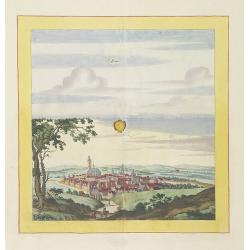
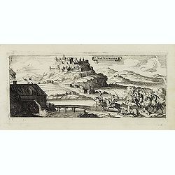
Laûn.
Very decorative and rare panoramic of Laun Louny a.d. Eger Böhmen.The engraver and publisher of prints, Mrs. Anna Beek of the Hague, enlarged the print and mounted it o...
Place & Date: The Hague, ca. 1700

Strasborcs In der Vocker Marckt.
Very decorative and rare panoramic town view of Völckermarckt in Kärten.The engraver and publisher of prints, Mrs. Anna Beek of the Hague, enlarged the print and mounte...
Place & Date: The Hague, ca. 1642

Statt Talbe an der Saal.
Very decorative and rare panoramic town view of Calbe a.d. Saale, Bez Magdeburg .The engraver and publisher of prints, Mrs. Anna Beek of the Hague, enlarged the print and...
Place & Date: The Hague, ca. 1642
Bützom.
Very decorative and rare panoramic town view of Bützom.The engraver and publisher of prints, Mrs. Anna Beek of the Hague, enlarged the print and mounted it on larger pap...
Place & Date: The Hague, ca. 1642
Werben.
Very decorative and rare panoramic town view of Werben a.d. Elbe, Bez. Magdeburg.The engraver and publisher of prints, Mrs. Anna Beek of the Hague, enlarged the print and...
Place & Date: The Hague, ca. 1642

Czaslaw.
Very decorative and rare panoramic of Czaslaw, Caslav, Tschslau in Böhmen.The engraver and publisher of prints, Mrs. Anna Beek of the Hague, enlarged the print and moun...
Place & Date: The Hague, ca. 1642
S. Nicolaes.
Beautifully etched by Gasper Bouttats (1640-1695) of Szent-Nicolas (Madarsko). Published by Jacques Peeters.
- $150 / ≈ €140
Place & Date: Antwerp, c. 1684
Macedonia, Epirus et Achaia.
Nice map of northern Greece with the southern parts of present day Macedonia and Albania. Includes the region of Athens. Strapwork title cartouche and Spanish text on ver...
Place & Date: Amsterdam, 1650

Nova et recens emendata totius Regni Ungariae una cum adiacentibus et finitimis regionisbus delineatio.
Engraved map by Jan van Deutecum, here the very rare first edition published by Cornelis Nicola in Asterdam in 1596. In very attractive original coloring.A re-issued was ...
Place & Date: Amsterdam, Cornelius Nicol, 1596
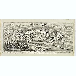
Rechnitz / Lewentz. (Breznica and Levice)
Magnificent bird's eye- of Breznica and Levice in Slovenia. Etched by Gaspar Bouttats (1640-1695).The Antwerp based publisher Jacques Peeters published ca. 1690 a series ...
- $150 / ≈ €140
Place & Date: Antwerp, c.1690
Haftwan. (Hatvan)
Magnificent bird's eye- of Hatvan. Etched by Gaspar Bouttats (1640-1695).The Antwerp based publisher Jacques Peeters published ca. 1690 a series of prints related to the ...
- $100 / ≈ €94
Place & Date: Antwerp, c.1690
Villeck. (Filakovo)
Magnificent bird's eye- of Filakovo. Etched by Gaspar Bouttats (1640-1695).The Antwerp based publisher Jacques Peeters published ca. 1690 a series of prints related to th...
- $150 / ≈ €140
Place & Date: Antwerp, c.1690
Sandrae. (Szendrö)
Magnificent bird's eye- of Szendrö. Etched by Gaspar Bouttats (1640-1695).The Antwerp based publisher Jacques Peeters published ca. 1690 a series of prints related to th...
- $100 / ≈ €94
Place & Date: Antwerp, c.1690
Tockay. (Tokaj)
Magnificent bird's eye- of Tokaj. Etched by Gaspar Bouttats (1640-1695).The Antwerp based publisher Jacques Peeters published ca. 1690 a series of prints related to the H...
- $150 / ≈ €140
Place & Date: Antwerp, c.1690
Sixo / Kalo. (Szikszo and Nagycallo)
Magnificent bird's eye- of Szikszo and Nagycallo. Etched by Gaspar Bouttats (1640-1695).The Antwerp-based publisher Jacques Peeters published ca. 1690 a series of prints ...
- $75 / ≈ €70
Place & Date: Antwerp, c.1690
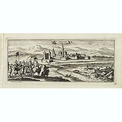
St:Servaes. (Szarvas)
Magnificent bird's eye- of Szarvas. Etched by Gaspar Bouttats (1640-1695).The Antwerp based publisher Jacques Peeters published ca. 1690 a series of prints related to the...
- $150 / ≈ €140
Place & Date: Antwerp, c.1690
Waradin.
Magnificent bird's eye- of Oradea. Etched by Gaspar Bouttats (1640-1695).The Antwerp based publisher Jacques Peeters published ca. 1690 a series of prints related to the ...
- $125 / ≈ €117
Place & Date: Antwerp, c.1690
Guyla.
Magnificent bird's eye- of Gyula. Etched by Gaspar Bouttats (1640-1695).The Antwerp based publisher Jacques Peeters published ca. 1690 a series of prints related to the H...
- $125 / ≈ €117
Place & Date: Antwerp, c.1690
Esseker brugh.
Fine print of the Esseker bridge in Osijek. Etched by Gaspar Bouttats (1640-1695).The Antwerp based publisher Jacques Peeters published ca. 1690 a series of prints relate...
- $125 / ≈ €117
Place & Date: Antwerp, c.1690
Stoe-Wysenburg.
Magnificent bird's eye- of Szekesfehervar. Etched by Gaspar Bouttats (1640-1695).The Antwerp based publisher Jacques Peeters published ca. 1690 a series of prints related...
- $125 / ≈ €117
Place & Date: Antwerp, c.1690
Vesprin.
Magnificent bird's eye- of Veszprem. Etched by Gaspar Bouttats (1640-1695).The Antwerp based publisher Jacques Peeters published ca. 1690 a series of prints related to th...
- $125 / ≈ €117
Place & Date: Antwerp, c.1690
Palotta.
Magnificent bird's eye- of Varpalota. Etched by Gaspar Bouttats (1640-1695).The Antwerp based publisher Jacques Peeters published ca. 1690 a series of prints related to t...
Place & Date: Antwerp, c.1690
Schombock.
Magnificent bird's eye- of Zsambek. Etched by Gaspar Bouttats (1640-1695).The Antwerp based publisher Jacques Peeters published ca. 1690 a series of prints related to the...
- $75 / ≈ €70
Place & Date: Antwerp, c.1690
St Martinsbergh.
Magnificent bird's eye- of Pannonhalma (Szentmártonhegy). Etched by Gaspar Bouttats (1640-1695).The Antwerp based publisher Jacques Peeters published ca. 1690 a series o...
- $75 / ≈ €70
Place & Date: Antwerp, c.1690
Nembti / Sengrot.
Magnificent bird's eye-town-views of Lenti and Zalaszengrot. Etched by Gaspar Bouttats (1640-1695).The Antwerp based publisher Jacques Peeters published ca. 1690 a series...
- $80 / ≈ €75
Place & Date: Antwerp, c.1690
Canisia.
Magnificent bird's eye- of Nagykanizas. Etched by Gaspar Bouttats (1640-1695).The Antwerp based publisher Jacques Peeters published ca. 1690 a series of prints related to...
- $90 / ≈ €84
Place & Date: Antwerp, c.1690
Carte topographique d'Allemagne contenant une partie du royaume de Boheme. . .
Detailed map cantered on Prague, Caaden, Laim, Melnik… Map 43 of the multi sheet map "Carte topographique d'Allemagne" of German Empire. Published by Johann W...
- $100 / ≈ €94
Place & Date: Frankfurt, ca.1780
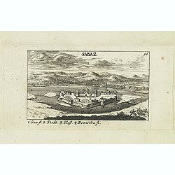
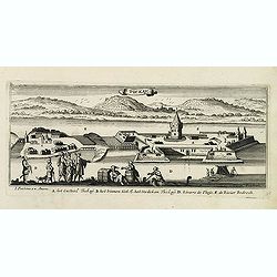
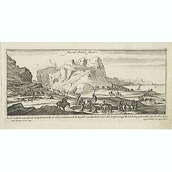
Sabaz. (Sabac)
View of Šabac in western Serbia, along the Sava river.Published in "Der Donau-Strand Mit allen seinen Ein- und Zuflüssen. . .". Published by Jacob Sandrart.
- $75 / ≈ €70
Place & Date: Nuremberg, Jacob Sandrart, 1684
Vesprin.
Panoramic view of Veszprém is one of the oldest urban areas in Hungary, and a city with county rights. It lies approximately 15 km north of the Lake Balaton. Published i...
- $90 / ≈ €84
Place & Date: Nuremberg, Jacob Sandrart, 1684
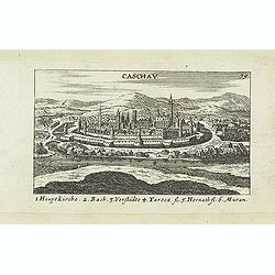
Caschav.
Panoramic view of Caschav (Cassovie). Published in "Der Donau-Strand Mit allen seinen Ein- und Zuflüssen. . .". Published by Jacob Sandrart.
- $100 / ≈ €94
Place & Date: Nuremberg, Jacob Sandrart, 1684
![Weitzen [Vác / Waitzen]](/uploads/cache/30817-250x250.jpg)
Weitzen [Vác / Waitzen]
Panoramic view of Vác / Waitzen with the Donau in the foreground Published in "Der Donau-Strand Mit allen seinen Ein- und Zuflüssen. . .". Published by Jacob ...
- $90 / ≈ €84
Place & Date: Nuremberg, Jacob Sandrart, 1684
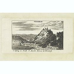
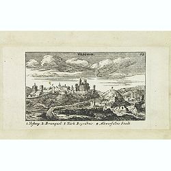
Vicegrad.
Panoramic view of Vicegrad. Published in "Der Donau-Strand Mit allen seinen Ein- und Zuflüssen. . .". Published by Jacob Sandrart.
- $100 / ≈ €94
Place & Date: Nuremberg, Jacob Sandrart, 1684
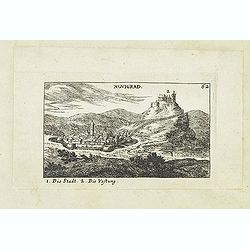
Novigrad.
Panoramic view of Nógrád in northern Hungary. Published in "Der Donau-Strand Mit allen seinen Ein- und Zuflüssen. . .". Published by Jacob Sandrart.
- $150 / ≈ €140
Place & Date: Nuremberg, Jacob Sandrart, 1684
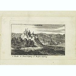
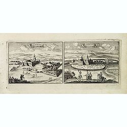
Filleck.
Panoramic view of Filleck (Fuleck, Filakovo). Published in "Der Donau-Strand Mit allen seinen Ein- und Zuflüssen. . .". Published by Jacob Sandrart.
- $150 / ≈ €140
Place & Date: Nuremberg, Jacob Sandrart, 1684
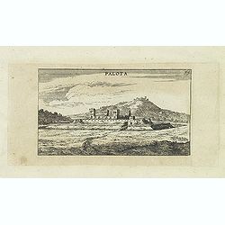
Palota.
Panoramic view of Palota in the Medzilaborce District in the Prešov Region of far north-eastern Slovakia. Published in "Der Donau-Strand Mit allen seinen Ein- und Z...
- $150 / ≈ €140
Place & Date: Nuremberg, Jacob Sandrart, 1684
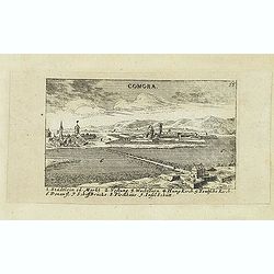
Comora.
Panoramic view of Comora. Published in "Der Donau-Strand Mit allen seinen Ein- und Zuflüssen. . .". Published by Jacob Sandrart.
- $100 / ≈ €94
Place & Date: Nuremberg, Jacob Sandrart, 1684
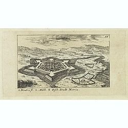
Neuhäusl. (Nové Zámky)
Panoramic view of Nové Zámky, in southwestern Slovakia.Published in "Der Donau-Strand Mit allen seinen Ein- und Zuflüssen. . .". Published by Jacob Sandrart.
- $75 / ≈ €70
Place & Date: Nuremberg, Jacob Sandrart, 1684
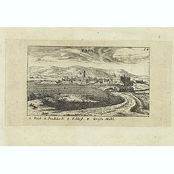
Papa.
Panoramic view of historical city Papa. Published in "Der Donau-Strand Mit allen seinen Ein- und Zuflüssen. . .". Published by Jacob Sandrart.
- $100 / ≈ €94
Place & Date: Nuremberg, Jacob Sandrart, 1684
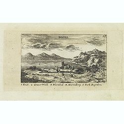
Dotis.
Panoramic view of Dotis (Tata). Published in "Der Donau-Strand Mit allen seinen Ein- und Zuflüssen. . .". Published by Jacob Sandrart.
- $150 / ≈ €140
Place & Date: Nuremberg, Jacob Sandrart, 1684
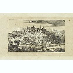
S. Martinsberg.
Panoramic view of S. Martinsberg. Published in "Der Donau-Strand Mit allen seinen Ein- und Zuflüssen. . .". Published by Jacob Sandrart.
- $100 / ≈ €94
Place & Date: Nuremberg, Jacob Sandrart, 1684