Browse Listings in Europe > Eastern Europe
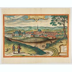
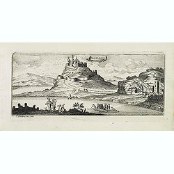
Polna vulgo Polm insign : Bohemia. . .
This is a view of Polna from the southwest looking across the Bohemian-Moravian Highlands from a slightly elevated viewpoint. In addition to the parish church (D) in the ...
Place & Date: Cologne, 1617
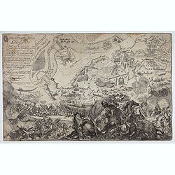
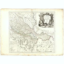
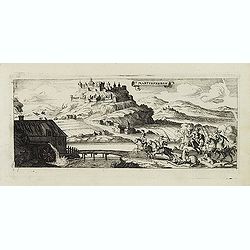
Delineatione della Piazza Forza di Belgrado.
Bird's-eye-bird view of The siege of Belgrade by the Austrian troops under the command of Prince Eugene of Savoy to capture the strategically important city from the Otto...
Place & Date: Rome, ca. 1700
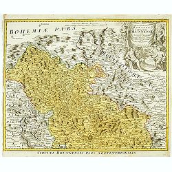
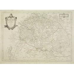
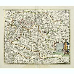
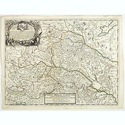
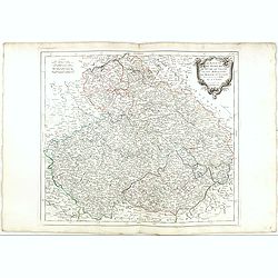
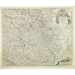
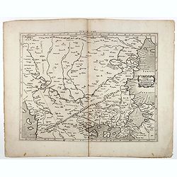
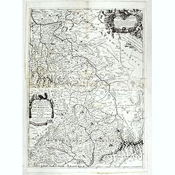
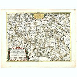
Marchionatus Moraviae circulus brunnensis..
Johann Baptist Homann's well-engraved map has a large decorative cartouche. Detailed map centered on Brunnensis, showing the main cities. Very decorative title cartouche ...
Place & Date: Nuremberg, 1744
Selling price: $200
Sold in 2008
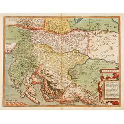
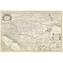
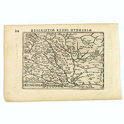
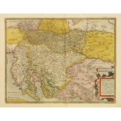
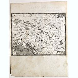
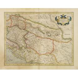
Illyricum.
Early map of Istria and Slovenia. Prepared by Johann Sambucus 1572.
Place & Date: Antwerp, 1574
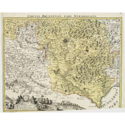
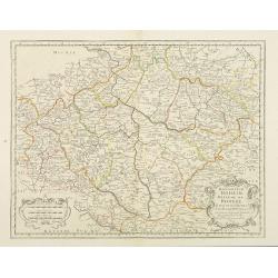
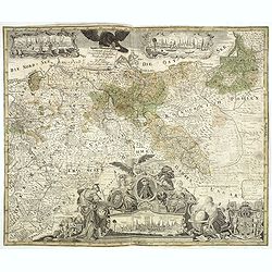
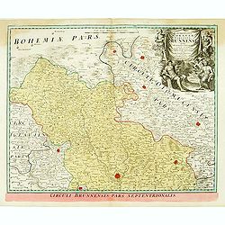
Circuli Brunnensis Pars Meridionalis.
Johann Baptist Homann's well-engraved and detailed map of the present-day South Moravia region centered on Brno, with decorative cartouche at the bottom.Johann Baptist Ho...
Place & Date: Nuremberg 1770 - 1774
Selling price: $250
Sold in 2008
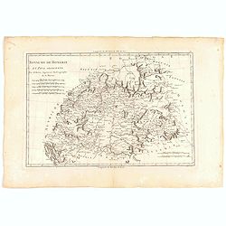
Royaume de Hongrie.
Detailed map encompassing present day Hungary with the river Danube and the towns of Belgrade, Budapest, Vienna, etc.Venetian edition of the map by Bellin, to whom Santin...
Place & Date: Venice, 1776 - 1784
Principauté de Transilvanie et Pays circonvoisins..
Detailed map encompassing part of present-day Hungary.From "Atlas Universel" published by Santini in 1784. The atlas is effectively an Italian copy of the Rober...
Place & Date: Venice, 1784
Le Royaume de Hongrie.
Fine oversized map of Hungary, but including Bosnia and Herzegovina, Bulgaria, Croatia, Romania, Albania, European part of Turkey, and Ukraine. With a decorative title an...
Place & Date: Amsterdam, 1692
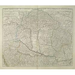
Carte Particuliere de la Hongrie de la Transilvanie de la Croatie et de la Sclavonie Dressée sur les Onservations de Mr. Le Comte Marsilli. . . Par G. Delisle.
Map of Hungary and Slovakia and adjacent parts of Croatia, Serbia and Romania (Transylvania). Prepared by Marsilli, published by Dezauche.
Place & Date: Paris, ca. 1780
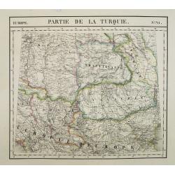
Europe. Partie de la Turquie. N°21.
Detailed map including Hungary and Romania.From his famous Atlas Universel . This atlas was one of the most remarkable world atlases ever produced, anticipating the Inter...
Place & Date: Brussels, 1825-1827
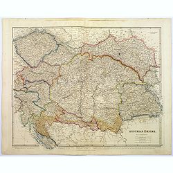
Austrian Empire.
A, large steel engraved map of the mighty Austrian Empire, covering Austria, Dalmatia, Styria, Slavonia, Hungary, Transylvania, Moravia and Bohemia. An enormous amount of...
Place & Date: London, 1839

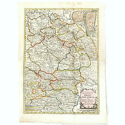
Le Royaume de Boheme, le Duché de Silesie, et les Marquisats de Moravie et Lusace, dresses d'apres les cartes de Muller . .
Map of Poland, Bohemia, Silesia, Moravia and Lusatia. Large decorative title cartouche in upper right. In upper left corner inset plan of Breslau and in lower right a ins...
Place & Date: Paris, 1790
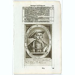
![[Portrait] - Me De Cet Corona se X+I. - Contantia et Fortudine](/uploads/cache/43510-250x250.jpg)
[Portrait] - Me De Cet Corona se X+I. - Contantia et Fortudine
Portrait of German Emperor Charles VI with his motto "Contantia et Fortudine". Holy Roman Emperor, 1711-1740, and King of Hungary as Charles III (1712-1740). Wi...
Place & Date: Germany, 1740
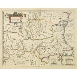
Walachia, Servia, Bulgaria, Romania.
Striking map of the region centered on the Lower Danube, Bulgaria, Romania, Serbia and Macedonia. Includes decorative cartouche, coat of arms, etc. Latin text on verso.Th...
Place & Date: Amsterdam, 1638
Karstia, Camiola, Histria et Windorum Marchia.
Including the Gulf of Trieste, Venice and the northern part of former Yugoslavia. Prepared by Gerard Mercator.As Willem Blaeu died in 1638 most of his maps are actually p...
Place & Date: Amsterdam, 1638
![Sopoto - Margaritino. [Sopot and Margarita in Albania]](/uploads/cache/45218-250x250.jpg)
Sopoto - Margaritino. [Sopot and Margarita in Albania]
Very rare view of Sopot and Margarita in Albania published in the first edition of "Viaggio da Venetia, a Costantinopoli. Per Mare, e per Terra, & infieme quello...
Place & Date: Venice, Giacomo Franco, 1598
Macedonia, Epirus et Achaia.
Nice map of northern Greece with the southern parts of present day Macedonia and Albania. Includes the region of Athens. Strapwork title cartouche and Spanish text on ver...
Place & Date: Amsterdam, 1650
![Fortezza Di Sopoto [Fortress of Sopot in Abania]](/uploads/cache/45216-250x250.jpg)
Fortezza Di Sopoto [Fortress of Sopot in Abania]
Very rare view of the Fortress of Sopot in Albania published in the first edition of "Viaggio da Venetia, a Costantinopoli. Per Mare, e per Terra, & infieme quel...
Place & Date: Venice, Giacomo Franco, 1598

Romaniae, (quae olim Thracia dicta) ..
Very fine map centered on the Danube area. The map is based on the double sheet map by Jacob Gastaldi. Abraham Ortelius (1527-1598) was a cartographer and publisher, who ...
Place & Date: Antwerp, 1598
Moraviae.
This early map of Slovakia was prepared by Paul Fabritius in 1569, centered on the city of Brno. Title cartouche on the upper left corner. Abraham Ortelius (1527-1598) wa...
Place & Date: Antwerp, 1598
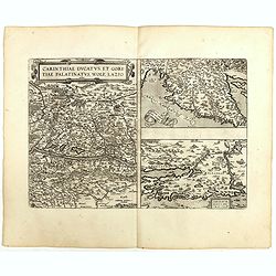
Carinthiae et Goritiae .. / Histria / Zarae / Serebenici. . .
Three maps on one sheet. The left hand is centered on the eastern part of Austria. The right upper hand map is centered on northern Yugoslavia, and the last map is center...
Place & Date: Antwerp, 1598
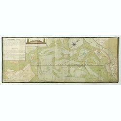
Situations = Plan. Der gegend zwischen der Kayserlich Königlichen Granitz Festung Essegg, und dem Dorffe Bellia....
Manuscript plan showing the Kopački Rit nature park a swampy area of Baranja between Osijek (Essegg) and Bilje. The river Drava in upper right corner. The pen an...
Place & Date: Vienna, 1819
Novissima et accuratissima totius Hungariae tabula. . .
Detailed map of Hungary with a decorative title cartouche with putti and an Ottoman warrior. The publisher gives credit to P. du Val in the title cartouche.
Place & Date: Amsterdam, 1700
Hungaria.
A lovely miniature map of Hungary, published by Petrus Bertius, in Amsterdam at the beginning of the seventeenth century. There is a decorative strap-work title, and the ...
Place & Date: Amsterdam, 1606
![Scutari [View of Shkodër - Albania]](/uploads/cache/45213-250x250.jpg)
Scutari [View of Shkodër - Albania]
Very rare view of Shkodër or Shkodra, historically known as Scutari or Scodra, is a city in the Republic of Albania. It is the capital of the surrounding county of Shkod...
Place & Date: Venice, Giacomo Franco, 1598
![Valona [ View of Valona]](/uploads/cache/45215-250x250.jpg)
Valona [ View of Valona]
Very rare view of Vlora in Albania published in the first edition of "Viaggio da Venetia, a Costantinopoli. Per Mare, e per Terra, & infieme quello di Terra Sant...
Place & Date: Venice, Giacomo Franco, 1598
![Antivari [View of Bar in Montenegro]](/uploads/cache/45214-250x250.jpg)
Antivari [View of Bar in Montenegro]
Very rare view of Bar in Montenegro published in the first edition of "Viaggio da Venetia, a Costantinopoli. Per Mare, e per Terra, & infieme quello di Terra San...
Place & Date: Venice, Giacomo Franco, 1598

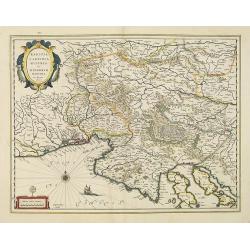
Schlavoniae, Croatiae, Carniale.. Bosniae. . .
First state. Fine and early map of former Yugoslavia after a map of Hirschvogel (1552-1565) and used by A.Ortelius in his atlas 'Theatrum Orbis Terrarum [Atlas of the Who...
- $400 / ≈ €374
Place & Date: Antwerp, 1579
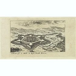
Neuhäusl. (Nové Zámky)
Panoramic view of Nové Zámky, in southwestern Slovakia.Published in "Der Donau-Strand Mit allen seinen Ein- und Zuflüssen. . .". Published by Jacob Sandrart.
- $75 / ≈ €70
Place & Date: Nuremberg, Jacob Sandrart, 1684
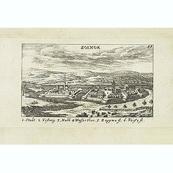
Zolnok.
Panoramic view of Szolnok (solnok) is the county seat of Jász-Nagykun-Szolnok county in central Hungary. Its location on the banks of the Tisza river, at the heart of th...
- $75 / ≈ €70
Place & Date: Nuremberg, Jacob Sandrart, 1684
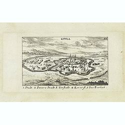
Gyula.
Panoramic view of Gyula in Békés County, Hungary. The town is best known for its Medieval castle and thermal bath. Published in "Der Donau-Strand Mit allen seinen ...
- $75 / ≈ €70
Place & Date: Nuremberg, Jacob Sandrart, 1684
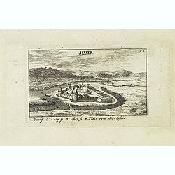
Sissek.
Panoramic view of Sisak in Sisak in central Croatia. Published in "Der Donau-Strand Mit allen seinen Ein- und Zuflüssen. . .". Published by Jacob Sandrart.
- $75 / ≈ €70
Place & Date: Nuremberg, Jacob Sandrart, 1684
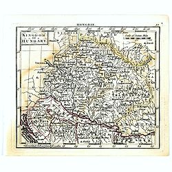
Kingdom of Hungary.
Uncommon miniature map of Hungary, engraved by Thomas Kitching for "A New General and Universal Atlas Containing Forty five Maps by Andrew Dury".This miniature ...
- $75 / ≈ €70
Place & Date: London, 1761-1763
Parte della Schiavonia, overo Slavonia, aggiuntavi la contea di Cilles e Windisch mark abitate da populi slavini, ò slavi. . .
The map of Slavonia by Cantelli from his atlas “Mercurio Geografico” issued in Rome in 1690 by the publisher and printer Giacomo Rossi. The map shows parts of the med...
- $400 / ≈ €374
Place & Date: Rome, 1690
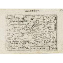
Sara et Zebenic.
A miniature map of the islands of Dalmatia. Title cartouche on the lower left side.First published in 1598 in his Caert-Thresoor, the plates were executed by the most fam...
- $100 / ≈ €94
Place & Date: Amsterdam / Frankfurt, 1609

Carta geographica generalatus carlostatuensiscum adgacentibus confinis turcicis et venetis...
Fine and rare manuscript map of Croatia and the Dalmatian coast from the early eighteenth century. Oriented to the south the map details the Venetian, Austrian and Turkis...
Place & Date: Venice , c. 1700
Royaume de hongrie et Pays Adjacents.
Map of the Northern part of the Kingdom of Naples, by Rigobert Bonne.
- $50 / ≈ €47
Place & Date: Paris, 1771
![[View of Osero].](/uploads/cache/45194-250x250.jpg)
[View of Osero].
Very rare view of Osor published in the first edition of "Viaggio da Venetia, a Costantinopoli. Per Mare, e per Terra, & infieme quello di Terra Santa. Da Giosep...
- $400 / ≈ €374
Place & Date: Venice, Giacomo Franco, 1598
Illyricum.
Early map of Istria and Slovenia. Prepared by Johann Sambucus 1572.The map is in a strictly contemporary coloring.Read more about coloring.
- $600 / ≈ €561
Place & Date: Antwerp, 1574
Royaume d'Esclavonie et du Duché De Syrmie..
Detailed map encompassing show us Danube and to the right Belgrade.From "Atlas Universel" published by Santini in 1776-84. The atlas is effectively an Italian c...
Place & Date: Venice, 1776 - 1784
Selling price: $70
Sold in 2015
Le Royaume de Boheme.. Moravie et Lusace.
Finely and crisply engraved map of Czechoslovakia, including Pilsen and part of Poland.Venetian edition of Giles Didier Robert De Vaugondy's map from Atlas Universel prin...
- $150 / ≈ €140
Place & Date: Venice, 1777 - 1784
Konigreich Boheim. Royaume de Boheme. . .
Covering Czech Republic and centered on Prague. Nicolas Sanson was to bring about the rise of French cartography, although the fierce competition of the Dutch would last ...
- $300 / ≈ €281
Place & Date: Paris, 1654
Rom: Keyserl. Majest. Königl Hoher Allierten Kriegs Theatrum von Schlesien, Böhmen, Maehren u: Oestereich. . .
A rare map centred on Austria, eastern Germany, Poland and Tsjechië. In upper right corner an inset plan of Prague. Showing the situation of the first Silesian War of 17...
- $900 / ≈ €842
Place & Date: Nuremberg, 1742
Lodovicus D.G. Rex Hungariae et Bohemiae Etc.
The engraving depicts a half length oval portrait of "Lodovicus D.G. Rex Hungariae et Bohemiae".Nicolaes de Clerck (de Klerc) was active as engraver and publish...
- $15 / ≈ €14
Place & Date: Amsterdam, Cloppenburch, 1621
Carte topographique d'Allemagne contenant une partie du royaume de Boheme. . .
Detailed map cantered on Prague, Caaden, Laim, Melnik… Map 43 of the multi sheet map "Carte topographique d'Allemagne" of German Empire. Published by Johann W...
- $100 / ≈ €94
Place & Date: Frankfurt, ca.1780
Karte von dem Konigreiche Boheim.
An attractive map of Bohemia. With a nice title cartouche decorated with cherubs in the upper right-hand corner. Engraved by Kil. Ponheimer.Franz Johann Josef von Reilly ...
- $300 / ≈ €281
Place & Date: Vienna, 1796
Regnum Bohemia.. Silesia.. Moravia, et Lusatia..
Detailed map of Czechoslovakia including the towns of Dresden, Prague, Breslau, etc. With fine title cartouche upper left, putti carrying the coats of arms of Bohemia, Mo...
- $400 / ≈ €374
Place & Date: Amsterdam, 1680
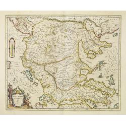
Tab. IX Europae, Continens Daciam, Misiam, Thraciam, ac Macedoniae partem.
Map of Dacia, Thrace and Macedonia -- or Byzantium from the Black Sea west to Greece. Including the site of Constantinople / Istanbul, the Dardanelles, Bosphorus, etc. By...
- $400 / ≈ €374
Place & Date: Amsterdam, c.1600
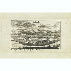
Sabaz. (Sabac)
View of Šabac in western Serbia, along the Sava river.Published in "Der Donau-Strand Mit allen seinen Ein- und Zuflüssen. . .". Published by Jacob Sandrart.
- $75 / ≈ €70
Place & Date: Nuremberg, Jacob Sandrart, 1684
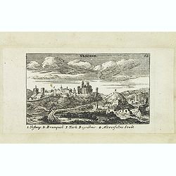
Vesprin.
Panoramic view of Veszprém is one of the oldest urban areas in Hungary, and a city with county rights. It lies approximately 15 km north of the Lake Balaton. Published i...
- $90 / ≈ €84
Place & Date: Nuremberg, Jacob Sandrart, 1684
![Weitzen [Vác / Waitzen]](/uploads/cache/30817-250x250.jpg)
Weitzen [Vác / Waitzen]
Panoramic view of Vác / Waitzen with the Donau in the foreground Published in "Der Donau-Strand Mit allen seinen Ein- und Zuflüssen. . .". Published by Jacob ...
- $90 / ≈ €84
Place & Date: Nuremberg, Jacob Sandrart, 1684
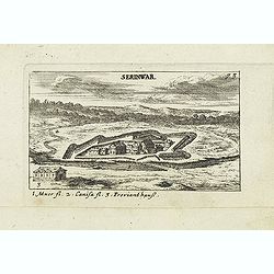
Serinwar. (Zrínyi vár)
Panoramic view of Zrínyi vár in Hungary. Published in "Der Donau-Strand Mit allen seinen Ein- und Zuflüssen. . .". Published by Jacob Sandrart.
- $90 / ≈ €84
Place & Date: Nuremberg, Jacob Sandrart, 1684
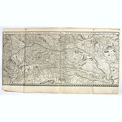
Tractus Danubii, Fluminis in Europa Maximi, A Fontibus, Per Germaniam. . .
This is Blaeu’s first map of the Danube and surrounding regions. The Danube River runs through the map from the top left with its headwaters in the German Black Forest ...
- $2000 / ≈ €1871
Place & Date: Amsterdam, 1634
Il Ducato di Silesia et il Marchesato di Moravia
Scarce two-sheet map of the region along the River Oder in Poland, including parts of Chez Republic and Hungary. Excellent detail throughout. Large and decorative title a...
- $1200 / ≈ €1123
Place & Date: Rome, 1692
Hungaria.
Small map of Hungary, surrounded by text in Dutch. Nicolaes de Clerck (de Klerc) was active as engraver and publisher in Delft from 1599-1621.Included in the rare book : ...
- $100 / ≈ €94
Place & Date: Amsterdam, Cloppenburch, 1621
Descritione dell Austria, et Ongheria, Transsilvania. . .
Rare war map showing Austria, Hungaria, Croatia, Slovakia, Venice, etc., being the battlefield of Christian Imperial vs. Islamic Ottoman forces from Vienna / Venice to Bu...
- $1000 / ≈ €936
Place & Date: Venice, Zaltieri, (1567) 1568

Paysan & Paysanne d'Hanas en Boheme.
Originally hand-colored mezzotint from 'Costumes civils actuels de tous les peuples connus'. Engraved by Lachaussée Jeune after Jacques Grasset de Saint-Sauveur.As an et...
- $50 / ≈ €47
Place & Date: Paris,1805
Il regno della Bossima diviso nelle sue provincie principali. . .
Rossi's map of Bosnia, based upon Sanson's map, but with revised Italian nomenclature. From a second edition of his 'Mercurio Geografico...'. The engraver was Cl. Botzot....
Place & Date: Rome, 1689
Generale Carte der gesamten Koniglichen Preussischen Lander. . .
Beautiful and rare two sheet map of Prussia. The title cartouche is hold by a crowned eagle. In lower part a large baroque cartouche with allegorical figures and a portra...
- $1200 / ≈ €1123
Place & Date: Berlin, 1760
![Durazo [ view of Durres in Albania]](/uploads/cache/45212-250x250.jpg)
Durazo [ view of Durres in Albania]
Very rare view of Durres in Albania published in the first edition of "Viaggio da Venetia, a Costantinopoli. Per Mare, e per Terra, & infieme quello di Terra San...
- $450 / ≈ €421
Place & Date: Venice, Giacomo Franco, 1598
![Liesena Isola [Hvar]](/uploads/cache/45202-250x250.jpg)
Liesena Isola [Hvar]
Very rare view map of the Island of Hvar published in the first edition of "Viaggio da Venetia, a Costantinopoli. Per Mare, e per Terra, & infieme quello di Terr...
- $400 / ≈ €374
Place & Date: Venice, Giacomo Franco, 1598
![Spalato [ View of Split]](/uploads/cache/45201-250x250.jpg)
Spalato [ View of Split]
Very rare view of Split published in the first edition of "Viaggio da Venetia, a Costantinopoli. Per Mare, e per Terra, & infieme quello di Terra Santa. Da Giose...
- $450 / ≈ €421
Place & Date: Venice, Giacomo Franco, 1598
![Citta Di Trav [Trogir]](/uploads/cache/45200-250x250.jpg)
Citta Di Trav [Trogir]
Very rare map centered on the historic town of Trogir published in the first edition of "Viaggio da Venetia, a Costantinopoli. Per Mare, e per Terra, & infieme q...
- $300 / ≈ €281
Place & Date: Venice, Giacomo Franco, 1598
Schombock.
Magnificent bird's eye- of Zsambek. Etched by Gaspar Bouttats (1640-1695).The Antwerp based publisher Jacques Peeters published ca. 1690 a series of prints related to the...
- $75 / ≈ €70
Place & Date: Antwerp, c.1690
![Glissa. [Klissza or Klis]](/uploads/cache/45203-250x250.jpg)
Glissa. [Klissza or Klis]
Very rare view of Klissza (Klis) published in the first edition of "Viaggio da Venetia, a Costantinopoli. Per Mare, e per Terra, & infieme quello di Terra Santa....
- $300 / ≈ €281
Place & Date: Venice, Giacomo Franco, 1598
![Budova [Budua in Montenegro]](/uploads/cache/45209-250x250.jpg)
Budova [Budua in Montenegro]
Scarce map centered on Budua in Montenegro was published in the first edition of "Viaggio da Venetia, a Costantinopoli. Per Mare, e per Terra, & infieme quello d...
- $450 / ≈ €421
Place & Date: Venice, Giacomo Franco, 1598
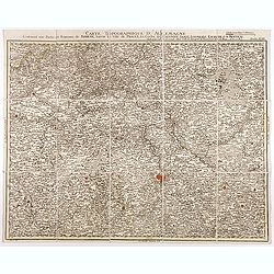
![[No title] Part of Eastern Europe, including Poland, the Czech Republic, Slovakia and Slovenia.](/uploads/cache/24266-250x250.jpg)
[No title] Part of Eastern Europe, including Poland, the Czech Republic, Slovakia and Slovenia.
Attractive map showing part of the course of the river Danube, from Germany to Hungary.Including Poland, the Czech Republic, Slovakia and Slovenia. Boundaries outlined in...
- $100 / ≈ €94
Place & Date: Paris, ca 1783
![[ Map with part of Albania]](/uploads/cache/45210-250x250.jpg)
[ Map with part of Albania]
Very rare view of part of the coast of Albania published in the first edition of "Viaggio da Venetia, a Costantinopoli. Per Mare, e per Terra, & infieme quello d...
- $450 / ≈ €421
Place & Date: Venice, Giacomo Franco, 1598
![Dulcigno [Ulcinj in Montenegro]](/uploads/cache/45211-250x250.jpg)
Dulcigno [Ulcinj in Montenegro]
Very rare view of Ulcinj in Montenegro published in the first edition of "Viaggio da Venetia, a Costantinopoli. Per Mare, e per Terra, & infieme quello di Terra ...
- $450 / ≈ €421
Place & Date: Venice, Giacomo Franco, 1598
Canisia.
Magnificent bird's eye- of Nagykanizas. Etched by Gaspar Bouttats (1640-1695).The Antwerp based publisher Jacques Peeters published ca. 1690 a series of prints related to...
- $90 / ≈ €84
Place & Date: Antwerp, c.1690
St Martinsbergh.
Magnificent bird's eye- of Pannonhalma (Szentmártonhegy). Etched by Gaspar Bouttats (1640-1695).The Antwerp based publisher Jacques Peeters published ca. 1690 a series o...
- $75 / ≈ €70
Place & Date: Antwerp, c.1690
Nembti / Sengrot.
Magnificent bird's eye-town-views of Lenti and Zalaszengrot. Etched by Gaspar Bouttats (1640-1695).The Antwerp based publisher Jacques Peeters published ca. 1690 a series...
- $80 / ≈ €75
Place & Date: Antwerp, c.1690

Sexta etas mudi CCXXXIX.
The Latin text page is describing the crusade against the Bohemian heretics in the time of emperor Sigismund Nuremberg Chronicle, published the year that Columbus returne...
- $150 / ≈ €140
Place & Date: Nuremberg, 12 July 1493
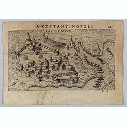
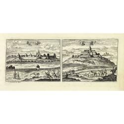
Castel Novo
Very rare view of Herceg-Novi, an important fortress belonging to Venetian Dalmatia captured during the 16th century by the Turks. Published in the first edition of "...
- $350 / ≈ €328
Place & Date: Venice, Giacomo Franco, 1598
Sclavonia, Croatia, Bosnia cum Dalmatiae parte.
Nice map of the Eastern Balkans with the political divisions of Slovenia, Croatia, Bosnia and Dalmatia.Mercator was born in Rupelmonde in Flanders and studied in Louvain ...
- $300 / ≈ €281
Place & Date: Amsterdam 1630
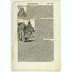
Sexta etas muidi Fo CCV.
The Latin text page is illustrating Baldwin (Baldvinus), the fourth of this name, seventh king of Jerusalem, and son of the aforesaid Amalric, reigned six years after his...
- $75 / ≈ €70
Place & Date: Nuremberg, 12 July 1493
Marchionatus Moraviae circulus brunnensis. . .
Johann Baptist Homann's well-engraved map has a large decorative cartouche. Detailed map centered on Bruenn in Moravia. Prepared by Johann Chr. Mueller. Very decorative t...
- $300 / ≈ €281
Place & Date: Nuremberg, 1740
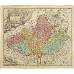
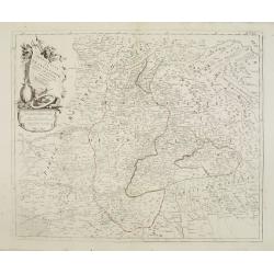
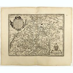
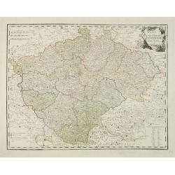
Tabula Generalis Marchionatus Moraviae..
Johann Baptist Homann's well-engraved map has a large decorative cartouche. Detailed map of the historic Moravia region of the Czech Republic, in the present-day Jihormor...
- $275 / ≈ €257
Place & Date: Nuremberg 1744
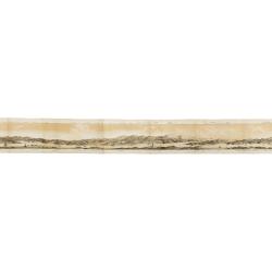
Panorama della Costa e delle Isole di Dalmazia nei viaggi dei piroscafi del Lloyd Austriaco.
On 20 August 1838 the Austrian Lloyd inaugurated a line service from Trieste to the Mouth of Cattaro. In order to illustrate the route, the Company asked the Trieste pain...
- $2500 / ≈ €2339
Place & Date: Trieste, Linassi, 1857
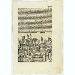
CCLXXV.
The Latin text page is illustrated with an imaginary view of a town in Macedonia (195 x 225mm.) The Nuremberg Chronicle, published the year that Columbus returned to Euro...
- $200 / ≈ €187
Place & Date: Nuremberg, 12 July 1493