Browse Listings in Europe > Eastern Europe

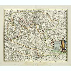
Carta geographica generalatus carlostatuensiscum adgacentibus confinis turcicis et venetis...
Fine and rare manuscript map of Croatia and the Dalmatian coast from the early eighteenth century. Oriented to the south the map details the Venetian, Austrian and Turkis...
Place & Date: Venice ?, c. 1700

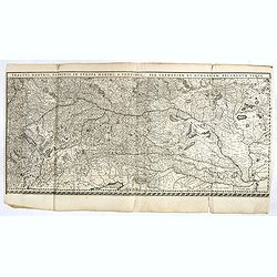
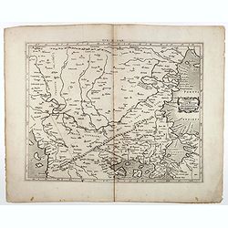
Tractus Danubii, Fluminis in Europa Maximi, A Fontibus, Per Germaniam. . .
This is Blaeu’s first map of the Danube and surrounding regions. The Danube River runs through the map from the top left with its headwaters in the German Black Forest ...
Place & Date: Amsterdam, 1634

Nova et recens emendata totius Regni Ungariae una cum adiacentibus et finitimis regionisbus delineatio.
Engraved map by Jan van Deutecum, here the very rare first edition published by Cornelis Nicola in Asterdam in 1596. In very attractive original coloring.A re-issued was ...
Place & Date: Amsterdam, Cornelius Nicol, 1596
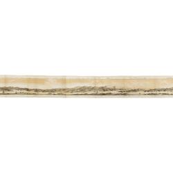
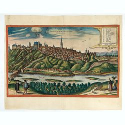
![Praga. [Prague]](/uploads/cache/28442-250x250.jpg)
Praga. [Prague]
A rare panoramic of Prague with over the whole length of the lower part 3 columns of poems in Latin, Dutch and French and a numbered key 1-34 to the principal buildings ...
Place & Date: Amsterdam, 1660
![.[Balkan region with Austria, Croatia, Slovenia, Switzerland, etc]](/uploads/cache/33858-250x250.jpg)
.[Balkan region with Austria, Croatia, Slovenia, Switzerland, etc]
Wood block printed map and one of earliest printed representation of Balkan with Austria, Croatia, Slovenia, Switzerland, etc prepared Martin Waldseemüller. Based on the...
Place & Date: Vienna, 1525 -1541

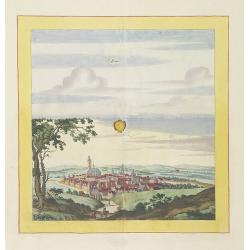
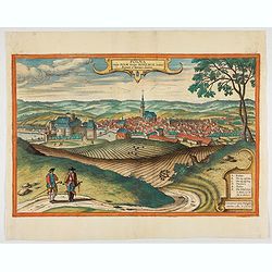
Launa vulgo Laun Bohemiae civitas.
Bird's-eye views of Louny in Bohemia by G. Hoefnagel. The copperplate was made for Braun and Hogenberg's town book. However there the print has been transformed by the en...
Place & Date: The Hague, 1700

Czaslaw.
Very decorative and rare panoramic of Czaslaw, Caslav, Tschslau in Böhmen.The engraver and publisher of prints, Mrs. Anna Beek of the Hague, enlarged the print and moun...
Place & Date: The Hague, ca. 1642

Statt Talbe an der Saal.
Very decorative and rare panoramic town view of Calbe a.d. Saale, Bez Magdeburg .The engraver and publisher of prints, Mrs. Anna Beek of the Hague, enlarged the print and...
Place & Date: The Hague, ca. 1642
![[Albania, Bulgaria, Europe, Eastern, Greece, Hungary, Macedonia, Romania]](/uploads/cache/33868-250x250.jpg)
[Albania, Bulgaria, Europe, Eastern, Greece, Hungary, Macedonia, Romania]
Wood block printed map and one of earliest printed representation of Albania, Bulgaria, Europe, Eastern, Greece, Hungary, Macedonia, Romania prepared Martin Waldseemülle...
Place & Date: Vienna, Trechsel, G., 1525 -1541
Panorama della Costa e delle Isole di Dalmazia nei viaggi dei piroscafi del Lloyd Austriaco.
On 20 August 1838 the Austrian Lloyd inaugurated a line service from Trieste to the Mouth of Cattaro. In order to illustrate the route, the Company asked the Trieste pain...
- $2500 / ≈ €2339
Place & Date: Trieste, Linassi, 1857

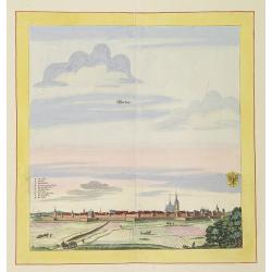
Strasborcs In der Vocker Marckt.
Very decorative and rare panoramic town view of Völckermarckt in Kärten.The engraver and publisher of prints, Mrs. Anna Beek of the Hague, enlarged the print and mounte...
Place & Date: The Hague, ca. 1642

Danubius Fluvius Europae Maximus, a Fontibus ad Ostia..
Depicts the course of the Danube River, from its sources in the Alps to the Black Sea..Because of the dimensions the map was printed from two copper plates.With two very ...
Place & Date: Amsterdam, 1638
Tractus Danubii, Fluminis in Europa Maximi, A Fontibus, Per Germaniam. . .
This is Blaeu’s first map of the Danube and surrounding regions. The Danube River runs through the map from the top left with its headwaters in the German Black Forest ...
- $2000 / ≈ €1871
Place & Date: Amsterdam, 1634
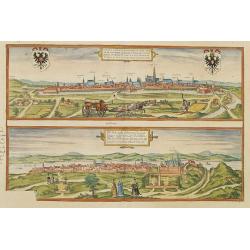
Vienna.. / Buda..
Pair of views on one sheet, the first showing the Austria capital of Vienna with fields, and figures in the foreground.Lower view shows the Hungarian capital of Budapest....
Place & Date: Cologne 1580
Bützom.
Very decorative and rare panoramic town view of Bützom.The engraver and publisher of prints, Mrs. Anna Beek of the Hague, enlarged the print and mounted it on larger pap...
Place & Date: The Hague, ca. 1642

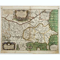
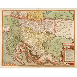
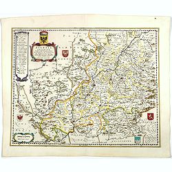
Carinthiae et Goritiae... / Histria tabula.../ Zarae, et Serebenici ..
Three maps on one sheet. The left hand is centered on the eastern part of Austria. The right upper hand map is centered on northern Yugoslavia, and the last map is center...
Place & Date: Antwerp, 1598
![Praghe. [ Prague ]](/uploads/cache/27801-250x250.jpg)
Praghe. [ Prague ]
A rare panoramic of Prague with over the whole length of the lower part 3 columns of poems in Dutch, French, German and English.Frederick de Wit published after 1694 a t...
- $2000 / ≈ €1871
Place & Date: Amsterdam, 1694
Laûn.
Very decorative and rare panoramic of Laun Louny a.d. Eger Böhmen.The engraver and publisher of prints, Mrs. Anna Beek of the Hague, enlarged the print and mounted it o...
Place & Date: The Hague, ca. 1700

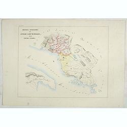
Carte du pays de Montenegro dressée d'après les opérations géodétiques . . .
Rare map of Montenegro prepared by Mr. le Comte Fedor de Karacsay (1787-1859) and engraved by Pietro Allodi. The title is in Russian, Arabic and French.In lower left corn...
- $1250 / ≈ €1170
Place & Date: Vienna, ca. 1838
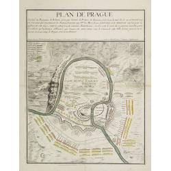
Plan de Prague.
Rare and separately published plan of Prague published by Joan Baptista Nolin with the address à l'enseigne de la Place des Victoires et chez le Sr. Humblot rue St. Jacq...
Place & Date: Paris, ca. 1742
Werben.
Very decorative and rare panoramic town view of Werben a.d. Elbe, Bez. Magdeburg.The engraver and publisher of prints, Mrs. Anna Beek of the Hague, enlarged the print and...
Place & Date: The Hague, ca. 1642
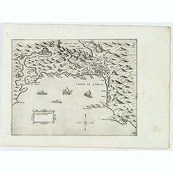
Golfo de Lodrin con parte di Albania.
Rare map of the northern coast of Albania, Serbia and Montenegro, extending from Malonta and Castel Novo and Bocca del Colfo di Cattaro to Durrës. Venetian war ships in ...
- $1500 / ≈ €1404
Place & Date: Venice, D.Bertelli, ca.1574
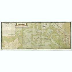
Situations = Plan. Der gegend zwischen der Kayserlich Königlichen Granitz Festung Essegg, und dem Dorffe Bellia....
Manuscript plan showing the Kopački Rit nature park a swampy area of Baranja between Osijek (Essegg) and Bilje. The river Drava in upper right corner. The pen an...
Place & Date: Vienna, 1819
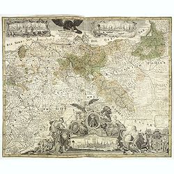
Generale Carte der gesamten Koniglichen Preussischen Lander. . .
Beautiful and rare two sheet map of Prussia. The title cartouche is hold by a crowned eagle. In lower part a large baroque cartouche with allegorical figures and a portra...
- $1200 / ≈ €1123
Place & Date: Berlin, 1760
![[Citta Di Ragusi]-[Citta Di Cataro]](/uploads/cache/32474-250x250.jpg)
[Citta Di Ragusi]-[Citta Di Cataro]
Uncommon map of the coast of Montenegro with the bay and town of Kotor (citta di Cataro) and Dubrovnik (cita di Ragusi) with Venetian war ships in the foreground. From Gi...
- $1250 / ≈ €1170
Place & Date: Venice, D.Bertelli, ca.1574
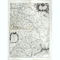
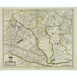
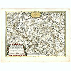
Il Ducato di Silesia et il Marchesato di Moravia
Scarce two-sheet map of the region along the River Oder in Poland, including parts of Chez Republic and Hungary. Excellent detail throughout. Large and decorative title a...
- $1200 / ≈ €1123
Place & Date: Rome, 1692

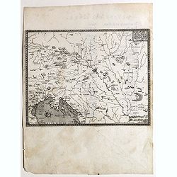
Marcomania hoggidi Merchesato de Moravia. . .
Although Komensky's map of Moravia was already known in his time, Coronelli used the obsolete map by Fabricius, with a lot of locations added by the publisher's unchained...
Place & Date: Venice, 1696
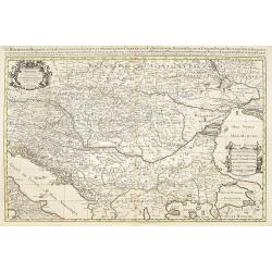
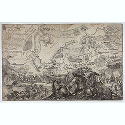
Descritione dell Austria, et Ongheria, Transsilvania. . .
Rare war map showing Austria, Hungaria, Croatia, Slovakia, Venice, etc., being the battlefield of Christian Imperial vs. Islamic Ottoman forces from Vienna / Venice to Bu...
- $1000 / ≈ €936
Place & Date: Venice, Zaltieri, (1567) 1568

Le Cours de l'Elbe et de l'Oder où sont les Electorats de Saxe et de Brandebourg, les Duchés de Mekelbourg et de Pomeranie. . .
A detailed and scarce map showing the rivers Elbe and Oder in Germany and Poland. Dark engraving.This is one sheet of the four sheet wall map by Pierre Du Val entitled: &...
Place & Date: Paris, 1684
![[Page with imaginary towns in Hungary. ] CCLXVIII](/uploads/cache/26932-250x250.jpg)
[Page with imaginary towns in Hungary. ] CCLXVIII
Page with imaginary towns in Hungary (230x225mm.) This leaf is from an edition of Hartmann Schedel's Liber chronicarum or Nuremberg Chronicle. The Chronicle was published...
Place & Date: Nuremberg, 1493
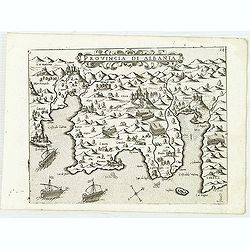
Provincia Di Albania.
Uncommon map of Albania, from Giovanni Francesco Camocio's rare " Isole Famose porti, fortezze, e terre maritime . . ." The second state, includes the plate n...
- $1200 / ≈ €1123
Place & Date: Venice, D.Bertelli, ca.1574
Hungaria regnum.
Detailed map of Hungary. First edition of Sanson's map of the Kingdom of Hungary. Engraved by A. Peyrounin.
Place & Date: Paris, ca. 1640
Le Royaume de Hongrie.
Fine oversized map of Hungary, but including Bosnia and Herzegovina, Bulgaria, Croatia, Romania, Albania, European part of Turkey, and Ukraine. With a decorative title an...
Place & Date: Amsterdam, 1692

Hongarije.
Poster made for Hungarian Tourist association. The uncommon Dutch version of this fine poster to promote Hungary in the 1930's. Arisztid Uher was a graphic designer. He d...
Place & Date: Budapest, KLOSZ / Sohn., ca. 1930
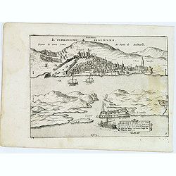
Sebenico antiquam.e Sico detto Citta nobile nella prouincia della Dalmacia. . .
Uncommon map of the coast of Croatia with the bay and town of Šibenik (Sebenico) with Venetian war ships in the foreground. From Giovanni Francesco Camocio's rare "...
- $1000 / ≈ €936
Place & Date: Venice, D.Bertelli, ca.1574
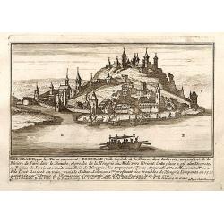
Belgrad / Biograd.
A very RARE panoramic view of the city of Belgrade, including a numbered legend in the lower part.Published by the brothers Chéreau, active in Paris at rue st.Jacques au...
Place & Date: Paris, c.1720
La Bulgaria ela Romania con Parte di Marcedonia. . .
Scarce map of the region along the Danube River and to the south. Extends to include part of the Sea of Azov and the northern extreme of the Aegean Sea. Elaborate militar...
- $600 / ≈ €561
Place & Date: Rome, 1689

Walachia Servia, Bulgaria, Romania.
The cartographer of this map was Gerard Mercator. This attractive map of the Eastern Balkans is centered on Bulgaria and includes the Bosphorus and Constantinople. The Da...
Place & Date: Oxford, 1680
Arcivescovato di Scopia e vicariati Apostolici nella Turchia Europea. (Tav XCVIII)
This large-format map of Eastern Europe, including Bosnia, Herzegovina, Albania, Montenegro, Servia, Bulgaria, Romania and Molavia. The map is finely engraved and beautif...
- $600 / ≈ €561
Place & Date: Rome, 1858
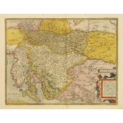
Illyricum.
Early map of Istria and Slovenia. Prepared by Johann Sambucus 1572.The map is in a strictly contemporary coloring.Read more about coloring.
- $600 / ≈ €561
Place & Date: Antwerp, 1574
Delineatione della Piazza Forza di Belgrado.
Bird's-eye-bird view of The siege of Belgrade by the Austrian troops under the command of Prince Eugene of Savoy to capture the strategically important city from the Otto...
Place & Date: Rome, ca. 1700
Rom: Keyserl. Majest. Königl Hoher Allierten Kriegs Theatrum von Schlesien, Böhmen, Maehren u: Oestereich. . .
A rare map centred on Austria, eastern Germany, Poland and Tsjechië. In upper right corner an inset plan of Prague. Showing the situation of the first Silesian War of 17...
- $900 / ≈ €842
Place & Date: Nuremberg, 1742
Provincia ecclesiastica di Antivari e arciv di durazzo nella Turchia Europae (Tav XCVII) ( Albania)
This large-format map of Albania with it's different dioceses. The map is finely engraved and beautifully colored and was prepared by Girolamo Petri, a lawyer who served ...
- $500 / ≈ €468
Place & Date: Rome, 1858
Il regno della Bossima diviso nelle sue provincie principali. . .
Rossi's map of Bosnia, based upon Sanson's map, but with revised Italian nomenclature. From a second edition of his 'Mercurio Geografico...'. The engraver was Cl. Botzot....
Place & Date: Rome, 1689
Znaymum vulgo Znaym, Moraviae Civitas Primaria.
Rare bird's-eye view of Znojmo (Znaim) Key to 12 locations.COMMENTARY BY BRAUN: "This is a beautiful and wealthy city in Moravia, situated on the border to Austria o...
- $750 / ≈ €702
Place & Date: Cologne, 1618

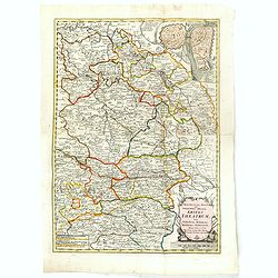
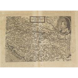
Carte de la Hongarie a l'Autriche. .
A detailed and scarce map showing Hungary and Austria engraved by de François Lapointe (Lépine). Dated 1664.With a dedication to Ferdinand-Ernest Comte d'Abensperg-Trau...
Place & Date: Paris, 1676

Vue et description des principales villes de l'Armenie et de la Georgie avec les habillements des femmes du pays, et ceux des prêtres et religieux armeniens. . .Tom: V N° 11 Pag: 28
View and description of the principal Armenian and Georgian cities with illustrations of Armenian women's garments as well as priests' and monks' clothing. The views are ...
Place & Date: Amsterdam, ca 1720
Trau citta nella Dalmacia vicino al Spaleto. . .
Uncommon map of the Dalmatian coast with the town of Trau (Trogir) in Croatia, from Giovanni Francesco Camocio's rare " Isole Famose porti, fortezze, e terre maritim...
- $1000 / ≈ €936
Place & Date: Venice, D.Bertelli, ca.1574
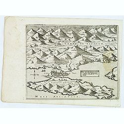
![[ Map with part of Albania]](/uploads/cache/45210-250x250.jpg)
[ Map with part of Albania]
Very rare view of part of the coast of Albania published in the first edition of "Viaggio da Venetia, a Costantinopoli. Per Mare, e per Terra, & infieme quello d...
- $450 / ≈ €421
Place & Date: Venice, Giacomo Franco, 1598
Polna vulgo Polm insign : Bohemia. . .
This is a view of Polna from the southwest looking across the Bohemian-Moravian Highlands from a slightly elevated viewpoint. In addition to the parish church (D) in the ...
Place & Date: Cologne, 1617
![Spalato [ View of Split]](/uploads/cache/45201-250x250.jpg)
Spalato [ View of Split]
Very rare view of Split published in the first edition of "Viaggio da Venetia, a Costantinopoli. Per Mare, e per Terra, & infieme quello di Terra Santa. Da Giose...
- $450 / ≈ €421
Place & Date: Venice, Giacomo Franco, 1598
Sclavonia Croatia, Bosnia & Dalmatiae Pars Maior.
Mattheus Quadt's map of the western Balkan with a portrait of the Roma.Matthias Quadt (1557-1613) was a Dutch geographer who worked in Cologne. From "Geographisch ha...
- $600 / ≈ €561
Place & Date: Cologne, 1600
Novissima et accuratissima totius Hungariae tabula. . .
Detailed map of Hungary with a decorative title cartouche with putti and an Ottoman warrior. The publisher gives credit to P. du Val in the title cartouche.
Place & Date: Amsterdam, 1700
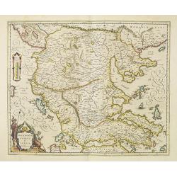
Tab. IX Europae, Continens Daciam, Misiam, Thraciam, ac Macedoniae partem.
Map of Dacia, Thrace and Macedonia -- or Byzantium from the Black Sea west to Greece. Including the site of Constantinople / Istanbul, the Dardanelles, Bosphorus, etc. By...
- $400 / ≈ €374
Place & Date: Amsterdam, c.1600
![Le Cours du Danube. . .[2 maps].](/uploads/cache/28472-250x250.jpg)
Le Cours du Danube. . .[2 maps].
Detailed two-sheet map of the course of the River Danube from its source up to Vienna. Showing the cities, like Linz, Passau, Straubing, Regensburg, Ulm, Augsburg, Munich...
- $450 / ≈ €421
Place & Date: Paris, 1705
Macedonia, Epirus et Achaia.
Nice map of northern Greece with the southern parts of present day Macedonia and Albania. Includes the region of Athens. Strapwork title cartouche and Spanish text on ver...
Place & Date: Amsterdam, 1650
Illyricum.
Early map of Istria and Slovenia. Prepared by Johann Sambucus 1572.
Place & Date: Antwerp, 1574
Parte della Schiavonia, overo Slavonia, aggiuntavi la contea di Cilles e Windisch mark abitate da populi slavini, ò slavi. . .
The map of Slavonia by Cantelli from his atlas “Mercurio Geografico” issued in Rome in 1690 by the publisher and printer Giacomo Rossi. The map shows parts of the med...
- $400 / ≈ €374
Place & Date: Rome, 1690
![Durazo [ view of Durres in Albania]](/uploads/cache/45212-250x250.jpg)
Durazo [ view of Durres in Albania]
Very rare view of Durres in Albania published in the first edition of "Viaggio da Venetia, a Costantinopoli. Per Mare, e per Terra, & infieme quello di Terra San...
- $450 / ≈ €421
Place & Date: Venice, Giacomo Franco, 1598
![[View of Osero].](/uploads/cache/45194-250x250.jpg)
[View of Osero].
Very rare view of Osor published in the first edition of "Viaggio da Venetia, a Costantinopoli. Per Mare, e per Terra, & infieme quello di Terra Santa. Da Giosep...
- $400 / ≈ €374
Place & Date: Venice, Giacomo Franco, 1598
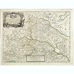
Marchionatus Moraviae circulus brunnensis..
Johann Baptist Homann's well-engraved map has a large decorative cartouche. Detailed map centered on Brunnensis, showing the main cities. Very decorative title cartouche ...
Place & Date: Nuremberg, 1744
Selling price: $200
Sold in 2008
Silesia Inferior. . .
Decorative map prepared by Jonas Scultetus, a Silesian cartographer (1603-1664). More about Willem Blaeu. [+]
- $300 / ≈ €281
Place & Date: Amsterdam, 1644
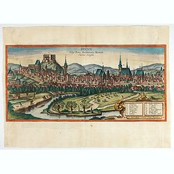
Brunn Vulgo Brinn Marchionatus Moraviae Civitas insignis.
Fine view of Brno seen from the southeast. TRANSLATION OF CAPTION: Brunn, in the vernacular Brno, eminent city in the Margravate of Moravia.COMMENTARY BY BRAUN: "Brn...
- $500 / ≈ €468
Place & Date: Cologne, 1618
![Valona [ View of Valona]](/uploads/cache/45215-250x250.jpg)
Valona [ View of Valona]
Very rare view of Vlora in Albania published in the first edition of "Viaggio da Venetia, a Costantinopoli. Per Mare, e per Terra, & infieme quello di Terra Sant...
Place & Date: Venice, Giacomo Franco, 1598
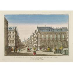
Vue perspective de la Place des Peintres ditte Perlach du cote de la Basse Ville a Prague.
A so-called optical print of a square in Prague by Basset, a well-known publisher of optical prints, was established in rue S.Jacques in Paris. With brief key list.In the...
Place & Date: Paris, 1760
Selling price: $400
Sold in 2014
![[Portrait] - Me De Cet Corona se X+I. - Contantia et Fortudine](/uploads/cache/43510-250x250.jpg)
[Portrait] - Me De Cet Corona se X+I. - Contantia et Fortudine
Portrait of German Emperor Charles VI with his motto "Contantia et Fortudine". Holy Roman Emperor, 1711-1740, and King of Hungary as Charles III (1712-1740). Wi...
Place & Date: Germany, 1740
![Dulcigno [Ulcinj in Montenegro]](/uploads/cache/45211-250x250.jpg)
Dulcigno [Ulcinj in Montenegro]
Very rare view of Ulcinj in Montenegro published in the first edition of "Viaggio da Venetia, a Costantinopoli. Per Mare, e per Terra, & infieme quello di Terra ...
- $450 / ≈ €421
Place & Date: Venice, Giacomo Franco, 1598

Romaniae, (quae olim Thracia dicta) ..
Very fine map centered on the Danube area. The map is based on the double sheet map by Jacob Gastaldi. Abraham Ortelius (1527-1598) was a cartographer and publisher, who ...
Place & Date: Antwerp, 1598
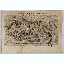
Castel Novo
Very rare view of Herceg-Novi, an important fortress belonging to Venetian Dalmatia captured during the 16th century by the Turks. Published in the first edition of "...
- $350 / ≈ €328
Place & Date: Venice, Giacomo Franco, 1598
Walachia, Servia, Bulgaria, Romania.
Striking map of the region centered on the Lower Danube, Bulgaria, Romania, Serbia and Macedonia. Includes decorative cartouche, coat of arms, etc. Latin text on verso.Th...
Place & Date: Amsterdam, 1638
![Budova [Budua in Montenegro]](/uploads/cache/45209-250x250.jpg)
Budova [Budua in Montenegro]
Scarce map centered on Budua in Montenegro was published in the first edition of "Viaggio da Venetia, a Costantinopoli. Per Mare, e per Terra, & infieme quello d...
- $450 / ≈ €421
Place & Date: Venice, Giacomo Franco, 1598

Schlavoniae, Croatiae, Carniale.. Bosniae. . .
First state. Fine and early map of former Yugoslavia after a map of Hirschvogel (1552-1565) and used by A.Ortelius in his atlas 'Theatrum Orbis Terrarum [Atlas of the Who...
- $400 / ≈ €374
Place & Date: Antwerp, 1579
Karte von dem Konigreiche Boheim.
An attractive map of Bohemia. With a nice title cartouche decorated with cherubs in the upper right-hand corner. Engraved by Kil. Ponheimer.Franz Johann Josef von Reilly ...
- $300 / ≈ €281
Place & Date: Vienna, 1796
Konigreich Boheim. Royaume de Boheme. . .
Covering Czech Republic and centered on Prague. Nicolas Sanson was to bring about the rise of French cartography, although the fierce competition of the Dutch would last ...
- $300 / ≈ €281
Place & Date: Paris, 1654
![Fortezza Di Sopoto [Fortress of Sopot in Abania]](/uploads/cache/45216-250x250.jpg)
Fortezza Di Sopoto [Fortress of Sopot in Abania]
Very rare view of the Fortress of Sopot in Albania published in the first edition of "Viaggio da Venetia, a Costantinopoli. Per Mare, e per Terra, & infieme quel...
Place & Date: Venice, Giacomo Franco, 1598
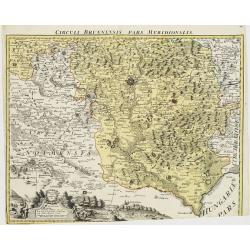
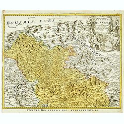
Circuli Brunnensis Pars Meridionalis.
Johann Baptist Homann's well-engraved and detailed map of the present-day South Moravia region centered on Brno, with decorative cartouche at the bottom.Johann Baptist Ho...
Place & Date: Nuremberg 1770 - 1774
Selling price: $250
Sold in 2008
Provincie ecclesiastiche di Leopoli e Fogaras ed Altre Diocesi di Rito Greco (Tav LXXV)
This large-format Romania map is finely engraved and beautifully colored and was prepared by Girolamo Petri, a lawyer who served as a senior official within the Vatican�...
- $250 / ≈ €234
Place & Date: Rome, 1858
Carinthiae et Goritiae .. / Histria / Zarae / Serebenici. . .
Three maps on one sheet. The left hand is centered on the eastern part of Austria. The right upper hand map is centered on northern Yugoslavia, and the last map is center...
Place & Date: Antwerp, 1598
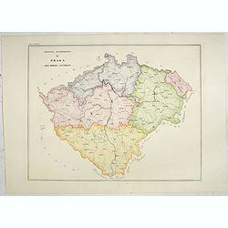
Provincia ecclesiastica di Praga nell' Impero Austriaco (Tav LXVIII)
A large-format map of Prague with its different dioceses. The map is finely engraved and beautifully colored and was prepared by Girolamo Petri, a lawyer who served as a ...
- $300 / ≈ €281
Place & Date: Rome, 1858

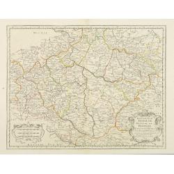
Le Royaume de Boheme, le Duché de Silesie, et les Marquisats de Moravie et Lusace, dresses d'apres les cartes de Muller . .
Map of Poland, Bohemia, Silesia, Moravia and Lusatia. Large decorative title cartouche in upper right. In upper left corner inset plan of Breslau and in lower right a ins...
Place & Date: Paris, 1790