Carte des Iles de Ponghou suivant le point sur lequel ont été faites les cartes de la Chine et de la Tartarie par l'ordre et aux frais de l'empereur. . .
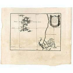
Plan of the West coast of Taiwan and it direct environs. From "Lettres Édifiantes et Curieuses. . Missionaires de la Compagnie de Jesus [Jesuit Letters]". Engr...
- $175 / ≈ €164
Place & Date: Paris, 1780-1783
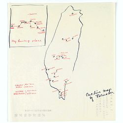
Map of Formosa. My hunting place.
An unusual hand drawn map of Formosa with an inset plan ‘My hunting place’. The map has the major cities marked in red ink and was made during Japanese occupation. Th...
Place & Date: Chiayi, Formosa, ca. 1940
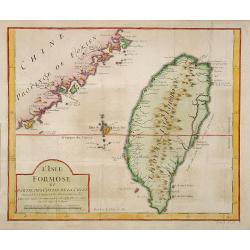
L'Isle Formose et parties des Costes de la Chine. . .
This well-known map of Taiwan is prepared by Jacques Nicolas Bellin and was based on Jesuit information. The text along the island's east-coast claims: Of this coast litt...
- $600 / ≈ €561
Place & Date: Paris, 1763
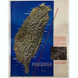
Formosa.
A large poster size map of the island of Formosa (Taiwan) off the Chinese mainland, prepared as a News Maps special edition during WWII. There is a red diagonal measureme...
- $750 / ≈ €702
Place & Date: New York, 1943
![Province de Fo-Kien. [Includes West Coast of Taiwan]](/uploads/cache/43503-250x250.jpg)
Province de Fo-Kien. [Includes West Coast of Taiwan]
Important map of Fujian Province, showing the east coast of China and the west coast of Taiwan. It shows that for the Manchu Qing, only the western half of Formosa was co...
Place & Date: The Hague, H. Scheurleer, 1737
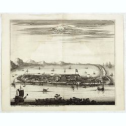
La Ville et le Château de Zélandia dans l' île de Tayovan.
This important copperplate engraving is one of the earliest European views of Taiwan, depicting the Dutch fortifications and trading settlement on the West coast of the i...
- $1800 / ≈ €1684
Place & Date: Amsterdam, 1675

Fokien Imperii Sinarum Provincia undecima.
The province of Fokien lies opposite Taiwan and south of the region described in the above map. The coast is shown from Wen-zhou in the north to Fu-zhou and as far south ...
Place & Date: Amsterdam, 1660
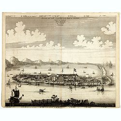
The citie and Castle Zelandia in the Island of Taywan. / Stadt en casteel Zelandia op 't Eilant Taywan.
This important copperplate engraving is one of the earliest European views of Taiwan, depicting the Dutch fortifications and trading settlements on the West coast of the ...
- $1500 / ≈ €1404
Place & Date: Amsterdam, 1675

Die Insel Formosa neu abgemessen auf Befehl Kaysers Kamhi.
One of the earliest obtainable printed map of Taiwan or Formosa Island. It was issued around 1726 to illustrate Joseph Stöcklein's [Stoecklein] compellation of Jesuit mi...
Place & Date: Augsburg, 1726
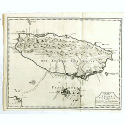
Kaart van het Eyland Formosa en de Eylanden van Piscadores.
The earliest printed map of Taiwan or Formosa. Oriented to the east, with north at the left, covering the entire island and the nearby Pescadores, now known as the Penghu...
- $4000 / ≈ €3743
Place & Date: Amsterdam, 1724