Browse Listings in Asia > South East Asia > Java / Bali
![[Manuscript chart on vellum of the Java Sea]](/uploads/cache/33613-250x250.jpg)
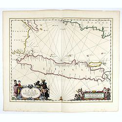
[Manuscript chart on vellum of the Java Sea]
One of the few manuscript charts on vellum in private hands, signed by Isaac de Graaf. ORIGINAL MANUSCRIPT MAP IN RED, GREEN AND BLACK INK showing the Java Sea centered o...
Place & Date: Amsterdam, 1743

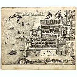
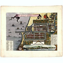
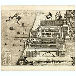
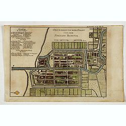
Waere affbeeldinge wegens het casteel ende stadt Batavia.
A good impression of this finely engraved and detailed plan of Batavia, present-day Jakarta, the Dutch center of trading activities in the East Indies. Copied after Cleme...
Place & Date: Amsterdam, 1681

Allerneuester geographisch- und topographischer Schau-Platz von Africa und Ost-Indien. . .
An early issue of this important book by Johann Wolfgang Heydt's describing the Dutch factories, settlements and stations at the hands of the Dutch East India Company in ...
Place & Date: Wilhermsdorf, Tetscher u. Nürnberg, Homanns Erben, 1744

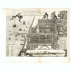
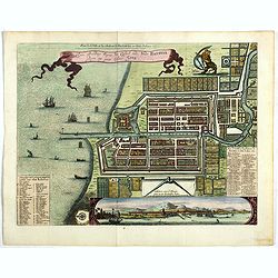
Waere Affbeeldinge Wegens het Casteel ende Stadt BATAVIA Gelegen opt Groot Eylant Java.
A good impression of this finely engraved and detailed plan of Batavia, present-day Jakarta, the Dutch center of trading activities in the East Indies. Copied after Cleme...
Place & Date: Amsterdam, 1721

Der Hollaendisch-Ostindianischen Compagnie Weltberühmte Haupt - Handels und Niederlags stadt BATAVIA..
Very fine decorative plan of Batavia showing the City and its immediate environs, the surrounding rice fields intersected by a network of waterways, canals and outlying f...
Place & Date: Nuremberg, 1733
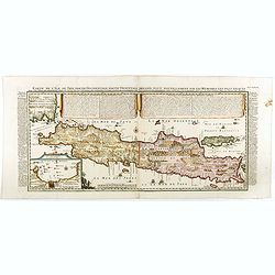
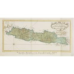
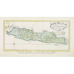
Insulae Iavae Cum parte insularum Borneo Sumatrae..
An elegant sea chart of the island of Java with parts of Sumatra, Borneo and Bali. The map includes only coastal detail and shows the Dutch capital in the East Indies at ...
Place & Date: Amsterdam, 1652

Carte de l'Ile de Java.
An inset plan of Batavia and clearly indicated rice fields, mountains, forests, towns in profile and even elephants suggest the wealth of detail found on this map. Modele...
Place & Date: Amsterdam, 1720
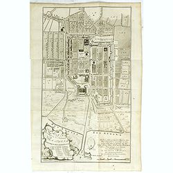
Plan der Stad en ‘t Kasteel BATAVIA. Aanwyzing der Stad en Kasteels Punten.
Very fine decorative plan of present-day Jakarta, showing the City and its immediate environs, the surrounding rice fields intersected by a network of waterways, canals a...
- $1750 / ≈ €1638
Place & Date: Amsterdam, 1782-1783

Carte de l'Ile de Java. . .
An inset plan of Batavia and clearly indicated rice fields, mountains, forests, towns in profile, and even elephants, suggesting the wealth of detail found on this map. M...
Place & Date: Amsterdam, 1720
Carte de l'Ile de Java: partie Occidentale, partie Orientale, Dressée tout nouvellement sur les Mémoirs les plus exacts, Avec une Table des principales villes de cette Ile. . .
One of the finest large-scale maps of Java, giving good information regarding the VOC settlements An inset plan of Batavia and clearly indicated rice fields, mountains, f...
- $1500 / ≈ €1404
Place & Date: Amsterdam, 1720

Straat Sunda en Westkust van Java.
Very large and rare chart depicting Java's western seacoast close to the Sunda Strait.Showing part of Sumatra on top and the West Java tip, today hosting the Ujung Kulon ...
- $1500 / ≈ €1404
Place & Date: Amsterdam (1841)1846

Kaart van de Reede van Batavia met de verschillende vaarwaters naar dezelve trigometrisch opgenomen op last van deb schout bijnacht E.Lucas.
Very large and rare so-called blue-black chart centered on Jakarta's harbor.The chart is prepared by B.G.Escher, I.A.C. Eschauzier, B.H.Staring and E.H.Boom during an exp...
- $2000 / ≈ €1871
Place & Date: Amsterdam (1841) 1847
Der Hollaendisch-Ostindianischen Compagnie Weltberühmte Haupt - Handels und Niederlags stadt BATAVIA..
A very fine decorative plan of Batavia showing the City and its immediate environs, the surrounding rice fields intersected by a network of waterways, canals and outlying...
Place & Date: Nuremberg, 1733
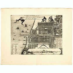
Waere affbeeldinge wegens het casteel ende stadt Batavia.
A good impression of this finely engraved and detailed plan of Batavia, present-day Jakarta, the Dutch center of trading activities in the East Indies. Copied after Cleme...
- $1100 / ≈ €1029
Place & Date: Leiden, 1719
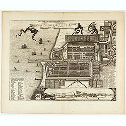
Waere affbeeldinge wegens het casteel ende stadt Batavia.
A good impression of Batavia's finely engraved and detailed plan, present-day Jakarta, the Dutch center of trading activities in the East Indies. Copied after Clement de ...
Place & Date: Leiden, 1719

Vue de L'Hotel de Batavie. . .
A so-called optical print of Fatahillah Square in Jakarta, Indonesia, prepared for use in a light-box or an amusing light-show. This richly hand colored print is much per...
Place & Date: Augsburg, 1750

Kaart van een gedeelte van de Noord Kust van Java en Straat Sunda van Tanjong Kaik tot den vierden hoek bij Anjer..
Very large and rare chart depicting Java's northern seacoast.Coastal profiles are present at the bottom of the map.The chart is prepared by B.H.Staring, J.A.G.Rietveld an...
- $1500 / ≈ €1404
Place & Date: Amsterdam 1843-1844
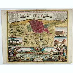
Plan de la Ville et du Chateau de Batavia en l'Isle de Iava / Ware affbeeldinge wegens het Casteel ende Stadt Batavia gelegen opt groot Eylant Java.
Detailed East oriented plan of Jakarta former Batavia on Java / Indonesia. With bird eye view from sea side, various ships and a lion. Two inset keys with detailed descri...
- $900 / ≈ €842
Place & Date: Leiden, 1730

Iava Maior.
Very fine miniature map of Java, engraved by Benjamin Wright (1575-1613). This early map contains detailed geography and nomenclature around the northern coastline of the...
Place & Date: Amsterdam, Cornelis Claes, 1606
Plan de la Ville et du Chateau de Batavia en l'Isle de Java.
Detailed dual language plan of Batavia, the capital of the Dutch East Indies.Batavia, today’s Indonesian capital of Jakarta, was the center of Dutch economic activity i...
- $800 / ≈ €749
Place & Date: Paris, 1719
Plan de la Ville et du Chateau de Batavia en l'Isle de Iava / Ware affbeeldinge wegens het Casteel ende Stadt Batavia gelegen opt groot Eylant Java.
Detailed East-oriented plan of Jakarta former Batavia on Java / Indonesia. With a bird's eye view from seaside, various ships and a lion. Two inset keys with detailed des...
- $750 / ≈ €702
Place & Date: Leiden, 1730
Ware affbeeldinge wegens het casteel ende stadt Batavia. . .
A reduced version of Clement de Jonghe (1650) plan of Jakarta from 1650. The town plan has a vignette at the bottom showing Jakarta from the sea with the volcanoes Mount ...
- $800 / ≈ €749
Place & Date: Leiden, 1719
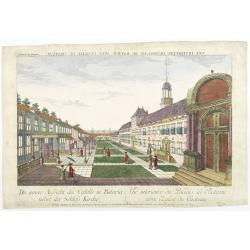
Die innere Aussicht des Castells in Batavia . . .
Showing the inside-square of the V.O.C. headquarters in Jakarta.The hand colored engraving is much perforated and the windows are cut out, a thin transparent paper is mou...
- $500 / ≈ €468
Place & Date: Augsburg, 1750
A Mapp of Batavia with all itts Forts.
Wonderful, scarce, and decorative plan of present-day Jakarta, showing the City and its immediate environs, the surrounding rice fields intersected by a network of waterw...
- $450 / ≈ €421
Place & Date: London, Printed for A. and J. Churchill, 1703
Plan de la Ville et du Chateau de Batavia en l'Isle de Iava / Ware affbeeldinge wegens het Casteel ende Stadt Batavia gelegen opt groot Eylant Java.
Detailed East-oriented plan of Jakarta former Batavia on Java / Indonesia. With bird's-eye view from sea side, various ships and a lion. Two inset keys with detailed desc...
Place & Date: Leiden, 1730
Selling price: $300
Sold in 2019
Nouvelle carte de l'Isle de Java.
A very nice map centred on the island of Java.With French text in title cartouche and an additional title in Dutch underneath the map.Read more Early maps of South East A...
Place & Date: Amsterdam, 1773
La Rade de Batavia . . .
Beautifully engraved map with elaborate cartouche of present-day Jakarta. From van der Aa's very rare work "La galerie agreable du Monde".
- $300 / ≈ €281
Place & Date: Leiden, 1719
Rivière de Sourabaya.
Early view of Surabaya on the island of Java after Paris and engraved in aquatint technique by Sigismond Himely (1801-1872). Published as plate 61 in Voyage autour du mon...
- $300 / ≈ €281
Place & Date: Paris, Finot, 1835
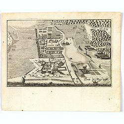
Grundriss von der Stadt und dem Schlosse Batavia.
Uncommon plan of the town and fortress of Batavia. The plan is based on the earlier, much larger map of Batavia published by Clement de Jonghe in 1650. From 'Algemeine We...
- $175 / ≈ €164
Place & Date: Halle, 1763-1792
![[View of the arrival of Cornelis de Houtman's fleet at Bantam, Java.].](/uploads/cache/37937-250x250.jpg)
[View of the arrival of Cornelis de Houtman's fleet at Bantam, Java.].
Engraved map of Bantam on Java with a lettered key (A-N) showing the arrival of Cornelis de Houtman’s fleet at Bantam, Java in 1596. Houtman’s four vessels, the Amste...
- $200 / ≈ €187
Place & Date: Amsterdam, Cornille Nicolas, 1609
Nouvelle carte de l'Isle de Java.
A very nice map centered on the island of Java. With French text in title cartouche and an additional title in Dutch underneath the map.Read more Early maps of South East...
Place & Date: Amsterdam, 1773
![[Bantam].](/uploads/cache/37970-250x250.jpg)
[Bantam].
Text engravings from "Premier livre de l'histoire de la navigation aux Indes Orientales, par les hollandois, et des choses a eux advenues . . . ", being the cla...
Place & Date: Amsterdam, Cornille Nicolas, 1609
![[Dutch ship Amsterdam].](/uploads/cache/37948-250x250.jpg)
[Dutch ship Amsterdam].
Text engraving of the Dutch vessel Amsterdam offshore the island of Java near Surabaya from "Premier livre de l'histoire de la navigation aux Indes Orientales, par l...
- $150 / ≈ €140
Place & Date: Amsterdam, Cornille Nicolas, 1609

Balinees watercolor on paper, fishermen.
Decorative export painting from Bali of a more than average quality.
- $150 / ≈ €140
Place & Date: Bali, ca 1960

Balinees watercolor on paper, fisherman.
Decorative export painting from Bali of a more than average quality.
- $150 / ≈ €140
Place & Date: Bali, ca 1960
Batavia, L'an 1629.
Scarce town-view of Batavia (Jakarta) in 1629.From the French reissue of the account of early Dutch voyages first published in 1608 by Commelin. The French translation wa...
- $150 / ≈ €140
Place & Date: Amsterdam, 1725
![[Celebrating the arrival of the Dutch in Turban].](/uploads/cache/37949-250x250.jpg)
[Celebrating the arrival of the Dutch in Turban].
Text engravings of a tournament in Turban. On 23rd January 1599, the Dutch landed at Turban (on the north coast of Java) with several small boats. Great crowds of people ...
- $150 / ≈ €140
Place & Date: Amsterdam, Cornille Nicolas, 1609
Banjowangui.
Early view of Banjowangui on the island of Java. Engraved in aquatint technique by Sigismond Himely (1801-1872) after Lauvergne. Published as plate 61 in Voyage autour du...
- $150 / ≈ €140
Place & Date: Paris, Finot, 1835
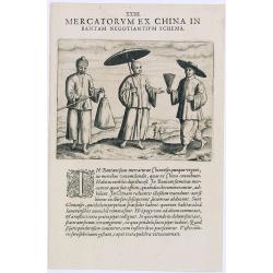
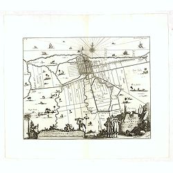
Mercatorum Ex China in Bantam Negotiantium Schema.
An early portrait of Chinese merchants in Banten (Bantam), a small port town near Java's western end.Theodore de Bry, a German engraver and book dealer, began a compilati...
- $100 / ≈ €94
Place & Date: Frankfurt, 1609
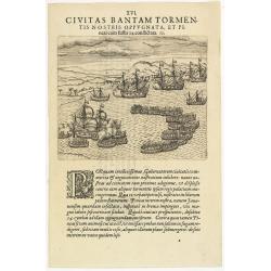
XVI. Civitas Bantam Tormentis nostris oppugnata . . .
Attack of Bantam (Banten), a city and former sultanate on Java island.Theodore de Bry, a German engraver and book dealer, began a compilation of early voyages in 1590 and...
- $100 / ≈ €94
Place & Date: Frankfurt, 1609