Browse Listings in Asia > Persia / Armenia / Iran / Irak

Quinta Asie Tabvla.
Woodblock map of Persia from Martin Waldseemüller's 1513 edition of Ptolemy, a landmark work that contributed to major advances in both Renaissance geography and map p...
Place & Date: Strasbourg, J. Schott, 1513
![.Tabula III Asiae. [Caucass and Armenia.]](/uploads/cache/27894-250x250.jpg)
.Tabula III Asiae. [Caucass and Armenia.]
Ptolemaic map of the region south of the Caucasus Mountains and between the Caspian Sea as far south as the headwaters of the Tigris River in the south and the Black Sea,...
Place & Date: Lyons, M. Servetus, 1535
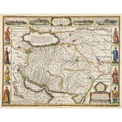
The Kingdom of Persia with the cheef Citties and Habites described by John Speede.
One of the most decorative "carte à figures"- maps of the old Kingdom of Persia, including modern day Iran and Iraq, as well as portions of the Turkish Empire,...
- $2000 / ≈ €1871
Place & Date: London, G.Humble, 1626
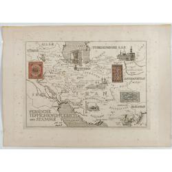
Persische Teppichknüpfgebiete und Stämme.
Map of Iran and neighboring countries in German language, published in limited edition probably in France : "Gravée à l'eau-forte et au burin. Edition limitée&quo...
Place & Date: France ?, after 1935 - before 1991

ARMENIEN. Costumes de l'Empire Ottoman 9.
A beautiful hand colored lithograph of an Armenian published in the French work "Galerie Royale de Costumes peints d´après nature par divers artistes et lithograph...
Place & Date: Paris, Chez Aubert & Cie., 1842-1848
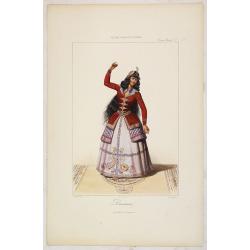
DANSEUSE. Costumes Persans 9.
A beautiful hand colored lithograph of an elegant dancing girl from Persia published in the French work "Galerie Royale de Costumes peints d´après nature par diver...
Place & Date: Paris, Chez Aubert & Cie., 1842-1848
Carte la plus nouvelle et plus exacte du royaume de Perse . . .
Decorative map of Persia. This well executed engraving was published in 1729 and 1727 by Pieter van der AA, in Leiden in "Les Voyages tres-curieux et tres-renommez f...
- $400 / ≈ €374
Place & Date: Leiden, 1719
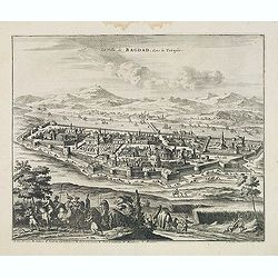
La Ville de Bagdad, dans la Turquie.
Decorative view of the town of Bagdad. This well executed engraving was published in 1729 and 1727 by Pieter van der AA, in Leiden in "Voyages tres-curieux et tres-r...
- $350 / ≈ €328
Place & Date: Leiden, 1719-1727
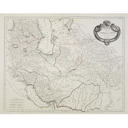
Carte de l'Empire de Perse. . .
Map of the Persian empire by the Venetian cartographer and publisher François (Père) Santini and first published in Santini's 'Atlas Universel dressée sur les meuilleu...
Place & Date: Venice, 1784
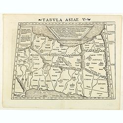
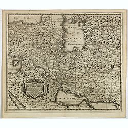
Tabula Asiae V. (Persia)
The first edition of Munster's map between the Persian Gulf and the Caspian Sea, extending from Armenia and Mesopotamia eastward, based upon Claudius Ptolemy which appear...
- $300 / ≈ €281
Place & Date: Basel, Heinrich Petri, 1545