Browse Listings in Asia > Persia / Armenia / Iran / Irak
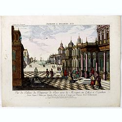
Vue du Pallais du l'Empereur de Perse avec la Mosquée, ou Eglise a Ispahan.
An optical print of the court of the Persian Emperor. Engraved by F.X. Habermann (1721-1796). The Academie Imperiale was a well-known publisher of optical prints, establi...
Place & Date: Augsburg, 1750
![Nouvelle carte de la province de Kilan en Persie . . . (Iran]](/uploads/cache/39437-250x250.jpg)
Nouvelle carte de la province de Kilan en Persie . . . (Iran]
Decorative map of southern part of the Caspian Sea in Northern Iran. This well executed engraving was published in 1729 and 1727 by Pieter van der AA, in Leiden in "...
- $300 / ≈ €281
Place & Date: Leiden, 1719
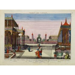
Vue des Promenades et les Fontaines d'Ispahan.
Carmine was a well-known publisher of optical prints, established in Augsburg.In the eighteenth and nineteenth centuries there were many popular specialty establishments ...
- $250 / ≈ €234
Place & Date: Augsburg 1770
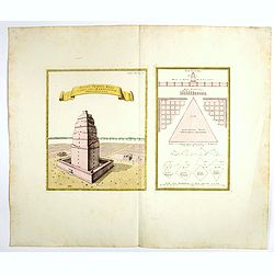
Totius Templi Beli et partis ubis Babylonicae prospectiva.
Two print on the same sheet, showing The Tower of Babe. The story of the city of Babel is recorded in Genesis 11:1–9. Everyone on earth once spoke the same language. As...
- $300 / ≈ €281
Place & Date: Nuremberg, 1750
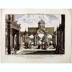
Vuë de la Cour de l'Empereur de Perse avec le diverses Habillements des Dames du premier Rang designe d'apres Nature par Quilielm Baur et fait en Estampe par François Xav. Habermann.
An optical print of the court of the Persian Emperor. Engraved by F.X. Habermann (1721-1796). The Academie Imperiale was a well-known publisher of optical prints, establi...
Place & Date: Augsburg, 1750
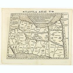
Tabula Asiae V. (Persia)
The first edition of Munster's map between the Persian Gulf and the Caspian Sea, extending from Armenia and Mesopotamia eastward, based upon Claudius Ptolemy which appear...
- $300 / ≈ €281
Place & Date: Basel, Heinrich Petri, 1545
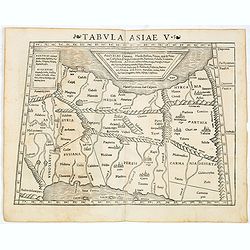
Tabula Asiae V (Persia)
The first edition of Munster's map between the Persian Gulf and the Caspian Sea, extending from Armenia and Mesopotamia eastward, based upon Claudius Ptolemy which appear...
- $300 / ≈ €281
Place & Date: Basel, Heinrich Petri, 1545
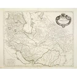
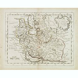
Carte de l'Empire de Perse..
Finely and crisply engraved map of Persia, ornated with a large rococo title cartouche. Boundaries outlined in hand color.Venetian edition of d'Anville's map, from "...
- $250 / ≈ €234
Place & Date: Venice, 1779 - 1784
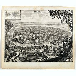
Isfahan.
An early of Isfahan in central Iran,. From the rare first edition "Offt begehrte Beschreibung der newen orientalischen Rejse, so durch Gelegenheit einer Holsteinisc...
- $250 / ≈ €234
Place & Date: Schleßwig, Zur Glocken, 1647
Le royaume de Perse. . .
Scarce map of Persia prepared by Nolin and published by L.J. Mondhare for his Atlas Général a l'usage des colleges et maisons d'education.. Louis Joseph Mondhare was ac...
- $200 / ≈ €187
Place & Date: Paris, 1783