![Repraesentatio Aedificiorum in Benyn, et Quid Praeterea notatu dignum ibi occurrat. [Execution of criminals in Benin.]](/uploads/cache/29834-250x250.jpg)
Repraesentatio Aedificiorum in Benyn, et Quid Praeterea notatu dignum ibi occurrat. [Execution of criminals in Benin.]
Execution of criminals in Benin. According to the text: The town of Benin is quite large and comprises homes with no windows, only open roofs. The more distinguished hous...
- $100 / ≈ €94
Place & Date: Frankfurt, 1609
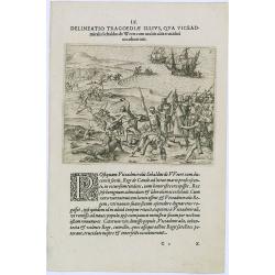
Delineatio Tragoediae Illius, Qua Viceadmiralis Sebaldus de Weert.
Event during Jan Harmensz Bree's account of the voyage to the East Indies in 1602-1604, under the command of Admirals Sebald De Weert and Pietersz to Ceylon, where de Wee...
- $150 / ≈ €140
Place & Date: Frankfurt, 1609
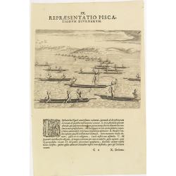
IX. Repraesentatio Piscationum Diurnarum.
Fishing offshore at the coasts of Guinea. Theodore de Bry, a German engraver and book dealer, began a compilation of early voyages in 1590 and had published six parts at ...
- $75 / ≈ €70
Place & Date: Frankfurt, 1609
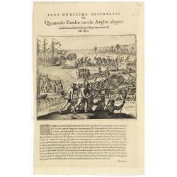
Pars Undecima Orientalis III. Quomodo Pembae incolae Anglos aliquot. . .
Finely engraved view of the arrival of Europeans at Pemba iIsland in Zanziba.Theodore de Bry, a German engraver and book dealer, began a compilation of early voyages in 1...
- $100 / ≈ €94
Place & Date: Frankfurt, 1609
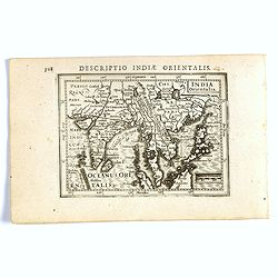
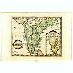
India Orientalis.
FIRST IMPRINT FROM THE NEWLY ENGRAVED PLATES IN 1616. - A rare miniature map of the East Indies.First published in 1598 in his Caert-Thresoor, the plates were executed by...
- $400 / ≈ €374
Place & Date: Amsterdam, J. Hondius, 1616
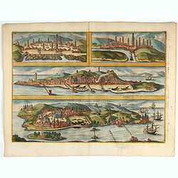
Casablanca (Anfa) - Azemmour (Azamor) - Diu - Old Goa (Velha Goa)
Four fine coastal views of these harbors cities which were important to Portuguese trade. Goa and Diu on the western coast of India, together with Anfa (Casablanc) and Az...
- $450 / ≈ €421
Place & Date: Cologne, 1618
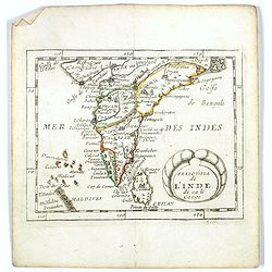
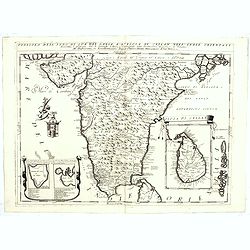
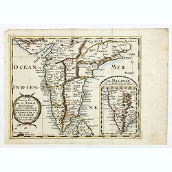
Malabar.
Small map illustrating the southwestern sea coast of India. Oriented with East on top, surrounded by text in Dutch.Included in the rare book : Wereld Spiegel, waer in ver...
- $200 / ≈ €187
Place & Date: Amsterdam, Cloppenburch, 1621
Malabar.
Small map illustrating the south western seacoast of India. Oriented with East on top, surrounded by text in Dutch.Nicolaes de Clerck (de Klerc) was active as engraver an...
- $175 / ≈ €164
Place & Date: Amsterdam, Cloppenburch, 1621
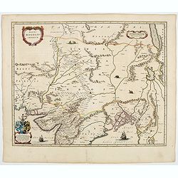
Bengala.
Small map centered on the Bay of Bengal, surrounded by text in Dutch. Nicolaes de Clerck (de Klerc) was active as engraver and publisher in Delft from 1599-1621.Included ...
- $150 / ≈ €140
Place & Date: Amsterdam, Cloppenburch, 1621
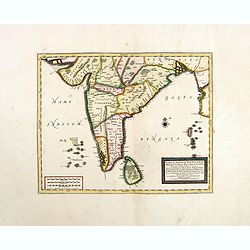
![Narsinga. [India]](/uploads/cache/38123-250x250.jpg)
Narsinga. [India]
Small map illustrating the Indian peninsular. Oriented with East on top, surrounded by text in Dutch.Nicolaes de Clerck (de Klerc) was active as engraver and publisher in...
- $225 / ≈ €211
Place & Date: Amsterdam, Cloppenburch, 1621
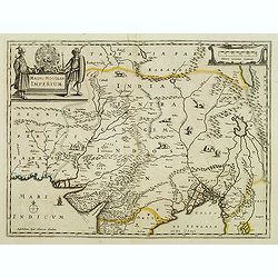
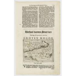
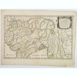
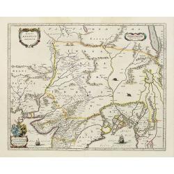
Magni Mogolis Imperium.
An attractive map of northern part of India, Tibet, Iran to Burma. The travel route from Kabul to Surat is the most prominent feature of the map. Richly decorated with st...
- $500 / ≈ €468
Place & Date: Amsterdam, after 1638
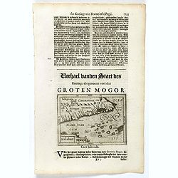
Magni Mogolis Imperium.
An attractive map of the region from Iran through Afghanistan, Tibet, and northern India across to Burma. The travel route from Kabul to Surat is the most prominent featu...
- $350 / ≈ €328
Place & Date: Amsterdam, 1644
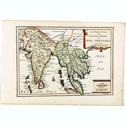
Partie Meridionale De L'Inde En deux Presqu'Isles l'une deca et l'autre Gange . . . 1654
Sanson's important mid-seventeenth-century map of India and Southeast Asia. At a scale of about 1:9,000,000, it covers most of modern India, Bangladesh and Burma, the who...
- $600 / ≈ €561
Place & Date: Paris, 1654
L'Inde deca et dela le Gange, ou est L'Empire du Grand Mogol. . .
An excellent mid 17th century map showing the area from Afghanistan and Pakistan in the west, and western China on the east, with most of India and extending north to the...
- $100 / ≈ €94
Place & Date: Paris, 1654
Magni Mogolis Imperium.
An attractive map of the northern part of India, Tibet, Iran to Burma. The travel route from Kabul to Surat is the most prominent feature of the map. Richly decorated wit...
- $650 / ≈ €608
Place & Date: Amsterdam, 1658
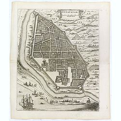
Negapatam.
Bird's-eye view of Nagapattinam or Negapatam, India, printed for the first Dutch edition of Baldaeus' work "A true and exact description of the most celebrated East-...
- $200 / ≈ €187
Place & Date: Amsterdam, 1672
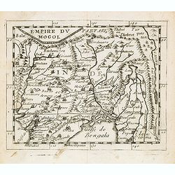
Empire du Mogol.
Uncommon miniature map of the Mongol empire from Pierre Duval's La Geographie Universeille dated 1676. Following his Cartes de geographie in 1657, Pierre Duval published ...
- $150 / ≈ €140
Place & Date: Paris, 1676
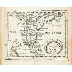
Presqu''isle de L'Inde de ça le Gange.
Uncommon miniature map of India from Pierre Duval's La Geographie Universeille dated 1676. Following his Cartes de geographie in 1657, Pierre Duval published this smaller...
- $150 / ≈ €140
Place & Date: Paris, 1676
Presqu''isle de L'Inde de ça le Gange.
Uncommon miniature map of India from Pierre Duval's La Geographie Universeille dated 1676. Following his Cartes de geographie in 1657, Pierre Duval published this smaller...
- $120 / ≈ €112
Place & Date: Paris, 1676
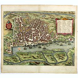
Goa.
A finely engraved, detailed plan of Goa. It also appeared in Gottfried’s Archontologia (1649). There is a cartouche identifying 43 buildings and the plan includes the h...
- $300 / ≈ €281
Place & Date: Frankfurt, 1680
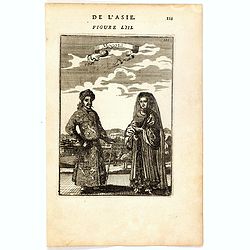
Mongols (De L'Asie / figure LIII).
A fine and uncommon early 17th century print of a Mogol couple.From the French text edition of "Description d'Univers", 1683. by Allain Manneson Mallet (1630-17...
- $80 / ≈ €75
Place & Date: Paris, 1683
India extra Gangem . . .
Map covering the subcontinent from the Bay of Bengal and the Gulf of Cambay to Ceylon (Sri Lanka) and offers impressive detail given that the interior of India was largel...
- $300 / ≈ €281
Place & Date: Utrecht / Amsterdam, J.Halma, 1683
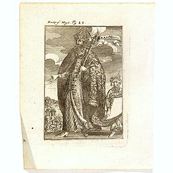
Der Grosse Mogol Fig LII.
A fine and uncommon early 17th century print of a Mogol.By Allain Manneson Mallet (1630-1706), a well traveled military engineer and geographer who worked in 17th century...
- $45 / ≈ €42
Place & Date: Frankfurt, 1684

Die Mogoler (Fig LIII).
A fine and uncommon early 17th century print of a couple at time of the Mughal Empire. Engraved by Joh. Jak. Vogel.By Allain Manneson Mallet (1630-1706), a well traveled ...
- $40 / ≈ €37
Place & Date: Frankfurt, 1684
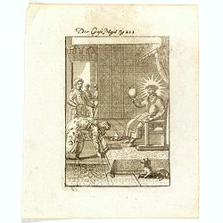
Grant Mogol - Der Graf Mogol (Fig LI).
A fine and uncommon early 17th century print of a Mughal emperor. Engraved by Joh. Jak. Vogel.By Allain Manneson Mallet (1630-1706), a well traveled military engineer and...
- $45 / ≈ €42
Place & Date: Frankfurt, 1684

Le Grand Mongol. . .
Rare full portrait of the Mongol emperor of Indostan, published by map seller, François Jollain, the Elder (1641-1704), active in Paris, rue St. Jacques à la ville de C...
Place & Date: Paris, ca. 1686
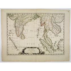
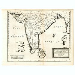
Penisola dell India di là dal Gange et Isole intorno ad essa adiacenti..
Giacomo Rossi's fine late 17th century map of India with Ceylon and Maldives. Issued in Il Mercurio geografico In lower right hand corner a large title cartouche with ded...
Place & Date: Rome, 1683-1688
Penisola dell'Indo di qua del Gange, e l isola di Ceilan..
India below the Tropic of Cancer, with an inset of Ceylon and Trincomalee.The remarkable Vincenzo Coronelli (1650-1718), encyclopaedist, geographer, inventor and Doctor o...
- $800 / ≈ €749
Place & Date: Venice, 1698
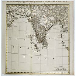
Carte d'une Partie des Indes Orientales, Etats du Mogol les Cotes de Malabar et de Coromandel.
A fine and highly detailed depiction of India and the surrounding region, this map extends from the Straits of Hormuz to the Gulf of Bengal. The Amsterdam publishing firm...
- $550 / ≈ €515
Place & Date: Amsterdam, 1700
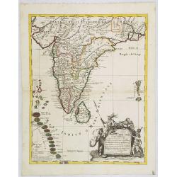
Presqu Isle de L'Inde. deca la Gange.. .
Two maps together on one sheet. General map showing the southern part of India, including the northern part of Shri Lanka. In an inset a detailed map of the most southern...
- $150 / ≈ €140
Place & Date: Amsterdam, 1700
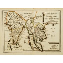
Les Vrays Indes dits Grands Indes ou Indes Orientales Par N. de Fer. Geographe de Sa Majeste Catoliques et de Monseigneur le Dauphin.
Detailed map on India, Thailand, the Malay Peninsular and the south coast of China up to Macao. The map was engraved by C. Inselin.
- $300 / ≈ €281
Place & Date: Paris, 1703
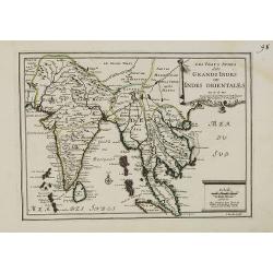
Les Vrays Indes dits Grands Indes ou Indes Orientales Par N. de Fer. Geographe de Sa Majeste Catoliques et de Monseigneur le Dauphin.
Detailed map on India, Thailand, the Malay Peninsular and the south coast of China up to Macao. The map was engraved by C. Inselin.
- $500 / ≈ €468
Place & Date: Paris, 1703
Les Vrays Indes dits Grands Indes ou Indes Orientales Par N. de Fer. Geographe de Sa Majeste Catoliques et de Monseigneur le Dauphin.
Detailed map on India, Thailand, the Malay Peninsular and the south coast of China up to Macao. The map was engraved by C. Inselin.
- $600 / ≈ €561
Place & Date: Paris, 1705
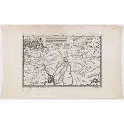
De Land-Reyse, door Benedictus Goes, van Lahor gedaan, door Tartaryen na China.
Interesting map showing the region of northeastern India, Nepal, Bhutan, Assam and Bangladesh. Canton in lower right corner.The map illustrates the narrative of the trave...
- $200 / ≈ €187
Place & Date: Leiden, 1707

De golf van Bengalen.
Rare chart of the Indian Ocean, with nice detail on Ceylon (Sri Lanka) with compass roses and a system of rhumb lines, soundings and anchorage's. Many place names. The pl...
Place & Date: Amsterdam, after 1669-1712
Carte du Golfe de Bengale, Mer de Indes, et Riviere du Gange, Avec les Pais et Iles d'alentour, Savoir les Cotes de Malabar, Cormandel, Ile de Ceylon, Les Maldives . . .
Detailed map of the Southern part of India with Ceylon. Good detail along the coasts of Malabar, Coromandel, the Maldives islands and the Kingdoms of Visipour, Golconda, ...
- $375 / ≈ €351
Place & Date: Leiden, 1719
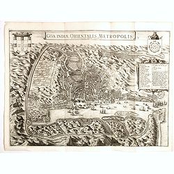
Goa Indiae orientalis metropolis.
A fine example of a rare plan of this important Indian city and port, the focal point for Portuguese trading activity in southern Asia. Pictorial map by Pieter Boudewyn v...
- $600 / ≈ €561
Place & Date: Leiden, 1719

Carte du Golfe de Bengale, mer des Indes et rivieres du Gange . . .
Detailed scare map of the Southern part of India with Ceylon. Good detail along the coasts of Malabar, Coromandel, the Maldives islands and the Kingdoms of Visipour, Golc...
Place & Date: Leide, 1719
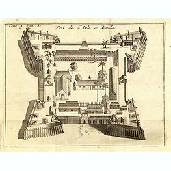
Fort de l'Isle de Banda.
Decorative print of the Dutch fortress on the island Banda.From the French reissue of the account of early Dutch voyages first published in 1608 by Commelin. The French t...
- $90 / ≈ €84
Place & Date: Amsterdam, F. Bernard, 1725