
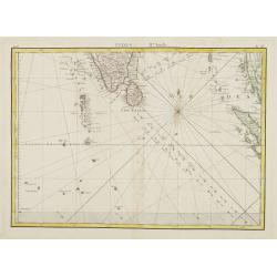
A chart of the northern part of the Indian Ocean..
Chart of the northern part of the Indian Ocean, including part of Arabia, India and Sri Lanka prepared by D'Apré de Mannevillette and published in London by Laurie and W...
- $750 / ≈ €702
Place & Date: London 1794

Carte de la Baye et du Port de Trinquemalay dans L'Isle de Ceylan.
Chart showing the bay of Trincomalee, Ceylon (Sri Lanka). Trincomalee is natural deep water port on the east coast of Sri Lanka, about 110 miles northeast of Kandy. It is...
- $450 / ≈ €421
Place & Date: Paris, 1775

Cochin (today: Ernakulam)
Small but charming 18th water color on paper depicting Cochin (today : Ernakulam) was from 1500, when the first Portuguese fleet called on its port, a firm ally of the Po...
Place & Date: India? c.1750

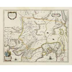
Nieuwe kaart van 't Koninckryk Bengale. . .
Rare map Bangladesh with the Ganges delta, including Calcutta. Giving great detail with trade routes, European trade settlements, etc. Prepared by Joh. Van Leenen who was...
Place & Date: Amsterdam, 1726
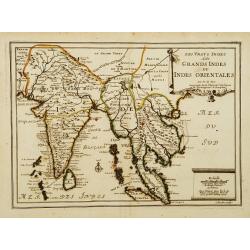
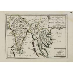
Les Vrays Indes dits Grands Indes ou Indes Orientales Par N. de Fer. Geographe de Sa Majeste Catoliques et de Monseigneur le Dauphin.
Detailed map on India, Thailand, the Malay Peninsular and the south coast of China up to Macao. The map was engraved by C. Inselin.
- $300 / ≈ €281
Place & Date: Paris, 1703
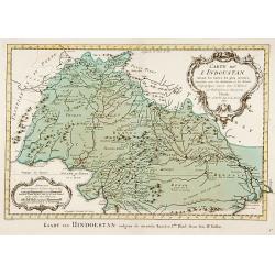
Carte de L'Indoustan. . .
Uncommon edition of this fine map of the northern part of India.From Atlas Portatif pour servir a l'intelligence de l'Histoire Philosophique et Politique des etablissemen...
- $150 / ≈ €140
Place & Date: Amsterdam, 1773
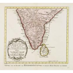
Suite de la Carte des L'Indoustan, Iie Feuille..
Uncommon edition of this fine map of India.From Atlas Portatif pour servir a l'intelligence de l'Histoire Philosophique et Politique des etablissements et du commerce des...
- $200 / ≈ €187
Place & Date: Amsterdam, 1773

Maldivae Insulae.
Very fine early miniature map of Maldives Islands. East is at the top. Title cartouche on the lower right corner. A dolphin and two ships are depicted.First published in ...
Place & Date: Amsterdam / Frankfurt, 1609
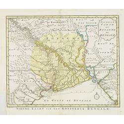
Nouvelle carte du Royaume de Bengale.
Uncommon issue of this detailed map of Bangladesh with the Ganges delta, including Calcutta. Giving great detail with trade routes, European trade settlements, etc. Prepa...
- $380 / ≈ €356
Place & Date: Amsterdam, 1773

Carte nouvelle des Terres de Cucan..
Prepared by H.Reland (1676-1718) a professor active in Utrecht and specialized in Asian languages, geography and religions. His first map was a map of Japan copied after ...
Place & Date: The Hague, 1728

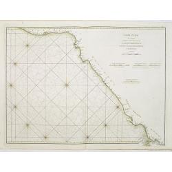
Carte réduite de l'Océan Oriental, depuis Le Cap de Bonne Espérance jusqu'à l'Isle Formose.
French chart covering the seas between the Cape of Good Hope until Taiwan and the West Coast of Australia. Prepared by Jacques-François L'Abbé Dicquemare (1733-1789). L...
- $1000 / ≈ €936
Place & Date: Paris, Brest, chez Demonville, 1775
Carte Plate qui comprend La partie septentrionale de LA Cöte de Coromandel et les Côtes de Golconde , D' Orcha et de Bengale.
French chart of Coromandel in India. West to the top.Latitude and longitude scales, compass rose and system of rhumb lines, soundings near coast and in bay areas.D' Aprè...
- $150 / ≈ €140
Place & Date: Paris, Brest, chez Demonville, 1775

Carte de la Côte de Guzerat, Du Golf de Cambaye et des Côtes de Concan et De Canara.
French sea chart of West India from Gujarat to Mangalore. With inset chart Plan de la Rivière de Surate.Prepared by Jacques-François L'Abbé Dicquemare (1733-1789). La...
Place & Date: Paris, ca 1775
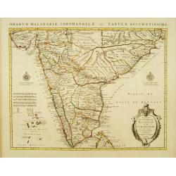
Carte des Côtes de Malabar et de Coromandel Presentée au Roy. . .
Large and attractive map of the Indian coasts of Malabar and Coromandel, embellished with title cartouche and 2 compass roses. It shows the most northern part of Ceylon.T...
- $500 / ≈ €468
Place & Date: Amsterdam c. 1745
![(2 charts of Shri Lanka) Mer des Indes - Ile de Ceylan - Partie Nord. Détroit de Palk et Golfe de Manaar.. [with] Partrie Sud...](/uploads/cache/23493-250x250.jpg)
(2 charts of Shri Lanka) Mer des Indes - Ile de Ceylan - Partie Nord. Détroit de Palk et Golfe de Manaar.. [with] Partrie Sud...
Two very large charts representing the northern and southern part of Sri Lanka and giving details about the Indian seacoast around the Gulf of Mannar and the Palk Strait....
- $750 / ≈ €702
Place & Date: Paris, 1866
![Bay of Bengal, compiled chiefly from government survey.. [2 sheets]](/uploads/cache/23495-250x250.jpg)
Bay of Bengal, compiled chiefly from government survey.. [2 sheets]
Large scale chart in 2 sheets focused on the Bay of Bengal.It covers Sri Lanka, the whole Indian eastern coast, the seacoast of Bangladesh, Myanmar and Thailand as far as...
- $1200 / ≈ €1123
Place & Date: London (1863), corrections to 1871
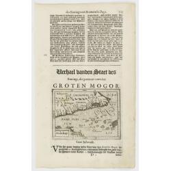
Magni Mogolis Imperium.
An attractive map of the northern part of India, Tibet, Iran to Burma. The travel route from Kabul to Surat is the most prominent feature of the map. Richly decorated wit...
- $650 / ≈ €608
Place & Date: Amsterdam, 1658
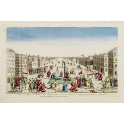
La Feste du Poids au Mogol qui se célebre chez ses Peuples avec grande vénération.
So-called optical print illustrating a perspective view of a square in Mongolia.Mondhare, active at rue St.Jacques a l'Hotel Saumur, was a well-known publisher of optical...
- $230 / ≈ €215
Place & Date: Paris, 1760
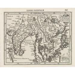
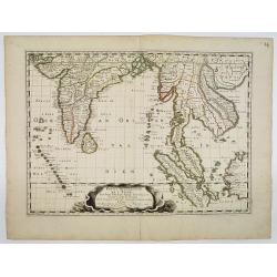
Indiae Orientalis.
This map covers an area including India, part of Malaysia, Borneo and China.From the first French-text edition of Jodocus Hondius' Atlas Minor.Shortly after the publicati...
Place & Date: Amsterdam, 1608
Indes. IIe. Feuille.
Attractive map of the southmost tip of India and Sri Lanka, including the Maldives and part of Sumatra. Boundaries are outlined in hand color.From the "Atlas moderne...
- $200 / ≈ €187
Place & Date: Paris ca 1783
Malabar.
Small map illustrating the southwestern sea coast of India. Oriented with East on top, surrounded by text in Dutch.Included in the rare book : Wereld Spiegel, waer in ver...
- $200 / ≈ €187
Place & Date: Amsterdam, Cloppenburch, 1621
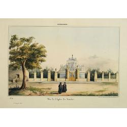
Pondichery - Vue de l'Eglise des Jésuites.
Lithography representing a view of a church belonging to the Jesuit order. Plate N° 11.From Souvenirs d'un voyage dans l'Inde, exécuté de 1834 à 1839, by A. Delessert...
- $300 / ≈ €281
Place & Date: Paris, 1843
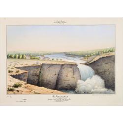
Southern - Concan.. - Nalkind or Kates Point..
Lithography representing a rocky landscape in the Western Ghats. Plate N° 12. From Souvenirs d'un voyage dans l'Inde, exécuté de 1834 à 1839, by A. Delessert.Adolphe ...
- $300 / ≈ €281
Place & Date: Paris, 1843
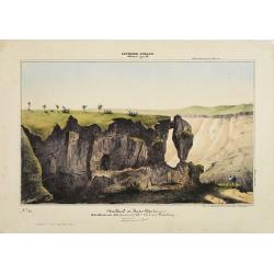
Southern - Concan.. - The falls of Gokank..
Hand colored lithography representing a view of the Gokak Falls, located on the Ghataprabha river. Plate N° 14. From Souvenirs d'un voyage dans l'Inde, exécuté de 1834...
- $250 / ≈ €234
Place & Date: Paris, 1843
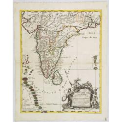
Les Vrays Indes dits Grands Indes ou Indes Orientales Par N. de Fer. Geographe de Sa Majeste Catoliques et de Monseigneur le Dauphin.
Detailed map on India, Thailand, the Malay Peninsular and the south coast of China up to Macao. The map was engraved by C. Inselin.
- $500 / ≈ €468
Place & Date: Paris, 1703

Le Grand Mongol. . .
Rare full portrait of the Mongol emperor of Indostan, published by map seller, François Jollain, the Elder (1641-1704), active in Paris, rue St. Jacques à la ville de C...
Place & Date: Paris, ca. 1686

De golf van Bengalen.
Rare chart of the Indian Ocean, with nice detail on Ceylon (Sri Lanka) with compass roses and a system of rhumb lines, soundings and anchorage's. Many place names. The pl...
Place & Date: Amsterdam, after 1669-1712
![[Mongolian pipe smoking ].](/uploads/cache/26258-250x250.jpg)
[Mongolian pipe smoking ].
Aquatint depicting a group of Mongolians in traditional attire during a pipe smoking ceremony. Chinese and Mongolian tradition had tobacco smoking from pipes with small m...
- $80 / ≈ €75
Place & Date: Milan, 1827
Penisola dell India di là dal Gange et Isole intorno ad essa adiacenti..
Giacomo Rossi's fine late 17th century map of India with Ceylon and Maldives. Issued in Il Mercurio geografico In lower right hand corner a large title cartouche with ded...
Place & Date: Rome, 1683-1688
Partie Meridionale De L'Inde En deux Presqu'Isles l'une deca et l'autre Gange . . . 1654
Sanson's important mid-seventeenth-century map of India and Southeast Asia. At a scale of about 1:9,000,000, it covers most of modern India, Bangladesh and Burma, the who...
- $600 / ≈ €561
Place & Date: Paris, 1654
![.Taprobana Ins. Tabula XII Asiae. [Sri Lanka.]](/uploads/cache/27928-250x250.jpg)
.Taprobana Ins. Tabula XII Asiae. [Sri Lanka.]
Ptolemy's mythical island of Taprobana originally became associated with Sri Lanka although it was sometimes confused with Sumatra. Taprobana, as it was called on most ea...
Place & Date: Lyons, M. Servetus, 1535
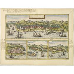
Calechut Celeberri mum Indiae Emporium/ Ormus/ Canonor, St.Georgii.
Four panoramic town-views on one sheet: The upper approximately two-thirds of this double page sheet contains a fine panoramic view of Calicut which is on the west coast ...
- $750 / ≈ €702
Place & Date: Cologne, 1580
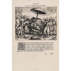
Lusitani in India deseruntur in Lecticis.
The way how the Portuguese carried a noble man in India from Linschoten's famous voyages to the East of 1583-92 here published by De Bry the year after they first appeare...
- $150 / ≈ €140
Place & Date: Frankfurt, 1599
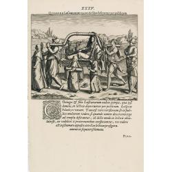
Quomodo Lusitanorum vxores & filiae deserrantur per publicum.
The way how the Portuguese carried a noble lady in India from Linschoten's famous voyages to the East of 1583-92 here published by De Bry the year after they first appear...
- $100 / ≈ €94
Place & Date: Frankfurt, 1599
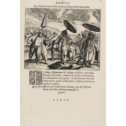
Peregrinationes noctu devotionis ergo à Lusitanis in India susceptae.
Showing Portuguese family in India from Linschoten's famous voyages to the East of 1583-92 here published by De Bry the year after they first appeared as a separate book....
- $150 / ≈ €140
Place & Date: Frankfurt, 1599
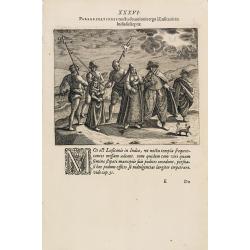
Quo habitu vulgus Lusitanorum in India per publicum incedat. (Portuguese citizens and soldiers in Goa)
This famous and desirable scene is showing comportment and dress of the Portuguese citizens and soldiers in East India as they appear in the streets from 1599. From Part ...
- $150 / ≈ €140
Place & Date: Frankfurt, 1599
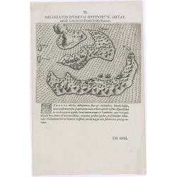
Delineatio Duorum Oppidorum, Ortat.
Early map of the Banda Islands.Theodore de Bry, a German engraver and book dealer, began a compilation of early voyages in 1590 and had published six parts at the time of...
- $200 / ≈ €187
Place & Date: Frankfurt, 1609

Expressio Germinum Quoque Aliorum, in S. Lavrentii.
Plants found in the island of S. Laurenti [Madagascar]. A’ denotes a tree with only a few twigs on the top. From this tree, canoes and boats are made. ‘B’ is a bush...
- $100 / ≈ €94
Place & Date: Frankfurt, 1609
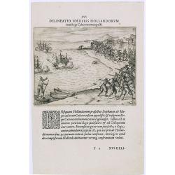
Delineatio Foederis Hollandorum cum Rege Calecutanorum pacti.
A treaty between the Dutch and the king of Calicut. The Dutch Admiral, Steffan van der Haagen already knew that the people of Calicut, on the Malabar Coast of India, were...
- $100 / ≈ €94
Place & Date: Frankfurt, 1609
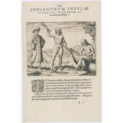
Indianorum, Insulae Pugnatan Incolarum. (The natives of the island of Pugnatan)
There was an island called Pugnatan at the western entrance to the Strait of Sudan, where the natives went about completely naked. Like the natives of Brazil, their hair ...
- $100 / ≈ €94
Place & Date: Frankfurt, 1609