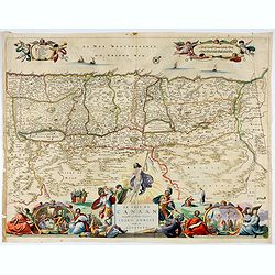
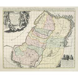
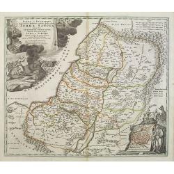
Browse Listings in Asia > Holy Land & Jerusalem
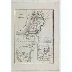
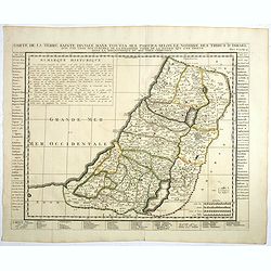
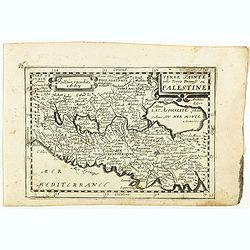
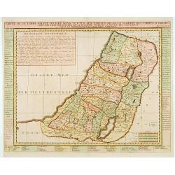
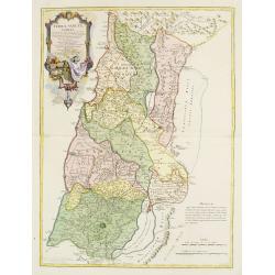
Carte de la Terre Sainte.
Detailed map of Israel, prepared by Charles V. Monin (fl.1830-1880) a French cartographer of Caen and Paris. Published in Atlas Universel de Géographie Ancienne &c M...
- $25 / ≈ €23
Place & Date: Paris, 1845
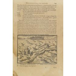
![[Illustration from Hierusalemsche Reyse.] Interieur of Church of the Holy Sepulchre.](/uploads/cache/30796-250x250.jpg)
[Illustration from Hierusalemsche Reyse.] Interieur of Church of the Holy Sepulchre.
Interior of a Church of the Holy Sepulchre. Below a decorative cartouche with lettered key and surrounded by 2 cherubins.Taken from a very rare travel book by Anthonius G...
- $30 / ≈ €28
Place & Date: Antwerpen, Michiel Cnobbaert, 1673
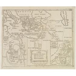
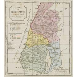
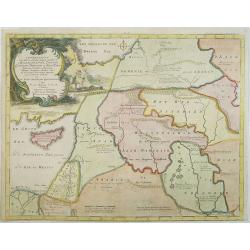
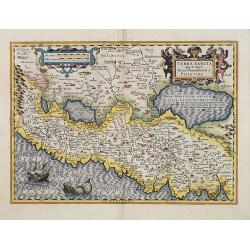
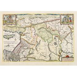
Carte des Régions et des Lieux dont il est parlé dans le Nouveau Testament.
Map of the eastern part of the Mediterranean with its hinterland. In the lower corners two inset maps: a plan of Jerusalem in the lower left, a map of Judea or Palestine ...
Place & Date: Paris, Prudhomme, Levrault, Debray, 1806
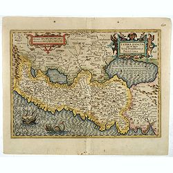
![[De terra sancta.]](/uploads/cache/32540-250x250.jpg)
[De terra sancta.]
On verso a map of the Middle East with Syria, Israel and Cyprus (123x158mm.). From a Latin text edition of his Geographia , that great compendium of Renaissance knowledge...
- $50 / ≈ €47
Place & Date: Basle, 1550-1590
![[Map of Palestine].](/uploads/cache/46175-250x250.jpg)
[Map of Palestine].
Alexey Afinogenovich Ilyin was a lieutenant general and cartographer (1832-1889). In 1856, after graduating from the Academy of the General Staff, he was at the military ...
- $100 / ≈ €94
Place & Date: St. Petersburg, 1899
![[Atrii Sancti ac Tabernaculi Foederisorthographia].](/uploads/cache/26474-250x250.jpg)
[Atrii Sancti ac Tabernaculi Foederisorthographia].
Campment in Israel.From an uncommon edition of Kerckelycke Historie van Neder-Landt which was a Dutch text edition of Agostino Torniello's Annales Sacri et Profani by Her...
- $50 / ≈ €47
Place & Date: Holland, ca. 1625
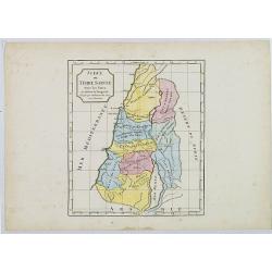
Carte des Douze Tribus d'Israel. . .
Attractive map centered on Israel, ornated with a large decorative title cartouche. Boundaries outlined in hand color.From theAtlas moderne ou collection de cartes sur to...
- $150 / ≈ €140
Place & Date: Paris, ca 1783
Judée ou Terre Sainte sous les Turcs.
Map of the Holy Land. By C. F. Delamarche, successor of Robert de Vaugondy, Geographer.
- $50 / ≈ €47
Place & Date: Paris, ca.1806
![[Lot of 8 leaves relating to the Holy Land]](/uploads/cache/48279-250x250.jpg)
[Lot of 8 leaves relating to the Holy Land]
Eight printed text leaves with maps and views relating to the Holy Land. From the 1552 Latin text edition of Münster's Cosmographia, which is a short and complete summar...
- $100 / ≈ €94
Place & Date: Basel, 1552
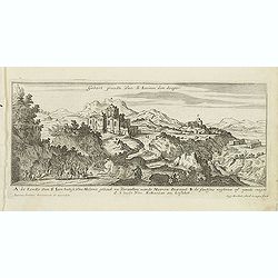
Gebort Plaedt Van S Ioannes des dooper. [Bith place of John Baptist)
Magnificent view of birthplace of John Baptist. Etched by Gaspar Bouttats (1640-1695).The Antwerp based publisher Jacques Peeters published ca. 1690 a series of prints re...
- $100 / ≈ €94
Place & Date: Antwerp, c.1690
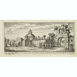
Gesicht in Jerusalem.
Magnificent bird's eye- of Jerusalem. Etched by Gaspar Bouttats (1640-1695).The Antwerp based publisher Jacques Peeters published ca. 1690 a series of prints related to t...
- $100 / ≈ €94
Place & Date: Antwerp, c.1690
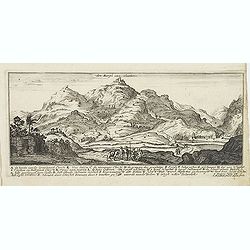
Den Bergh van olmeten. (Mount of Olives).
Magnificent view of the Mount of Olives, with the Church of the Ascension. Etched by Gaspar Bouttats (1640-1695).The Antwerp based publisher Jacques Peeters published ca....
- $100 / ≈ €94
Place & Date: Antwerp, c.1690
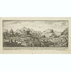
Jerusalem.
Magnificent bird's eye- of Jerusalem. Etched by Gaspar Bouttats (1640-1695).The Antwerp based publisher Jacques Peeters published ca. 1690 a series of prints related to t...
- $100 / ≈ €94
Place & Date: Antwerp, c.1690
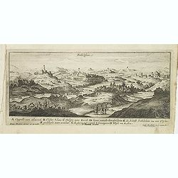
Bethlehem.
Magnificent bird's eye- of Bethlehem. Etched by Gaspar Bouttats (1640-1695).The Antwerp based publisher Jacques Peeters published ca. 1690 a series of prints related to t...
- $100 / ≈ €94
Place & Date: Antwerp, c.1690
Judée ou Terre Sainte.
Map of the Holy Land, Judea. By C. F. Delamarche, successor of Robert de Vaugondy, Geographer.
- $75 / ≈ €70
Place & Date: Paris, 1794 -1806
Montana Ivdeae. . .
Text page with copper engraved illustration of Mount Judea taken from Itinerarium Hierosolymitanum et Syriacum, in quo variarum Gentium Mores et Institua insularum, regio...
- $80 / ≈ €75
Place & Date: Antwerp, Verdussen, 1619
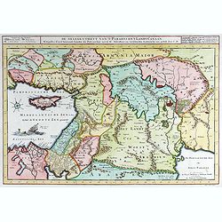
Carte générale pour servir à l'Intelligence de..
Fine map of the Middle East, including the Holy Land, Cyprus, Iran and Irak, etc.Philippe Buache was one of the most active proponents of the so-called, "school of t...
- $300 / ≈ €281
Place & Date: Paris, 1783
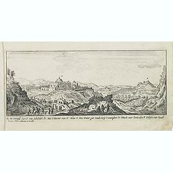
A. De Verualle Kerck Van Abakuck. . . .
Magnificent bird's eye- of Abakuck. Etched by Gaspar Bouttats (1640-1695).The Antwerp based publisher Jacques Peeters published ca. 1690 a series of prints related to the...
- $150 / ≈ €140
Place & Date: Antwerp, c.1690
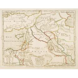
Turchia Nell' Asia antica, e moderna.
Rare map of Armenia, Palestine, Turkey and northern Arabia, from "Atlante Novissimo ad uso Dei Giovani Studiosi Contenuto In Carte XXVII.", published by Giovann...
- $200 / ≈ €187
Place & Date: Rome, 1780
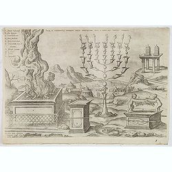
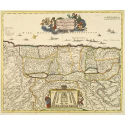
Sacri in tabernaculo apparatus partes ex descriptione Mosis. . .
Fine engraving of the brazen altar, bronze altar, or altar of sacrifice among other ritual objects such as the candelabrum. From Benedictus Arias Montanus' Antiquitatum I...
- $200 / ≈ €187
Place & Date: Antwerp, 1572 / Leiden, 1593
Quinta Etas Mundi. Folium. LXVI. (Visionary Temple of Ezekiel.)
The Latin text page is illustrated with on recto and verso depictions of the visionary Temple of Ezekiel. Kings.Page from the richest illustrated Incunable, the famous: N...
- $200 / ≈ €187
Place & Date: Nuremberg, 12 July 1493
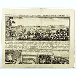
Vue et description de Bethleem et de Nazareth . . .
Decorative panoramic view of Bethlehem and Nazareth, among 3 other views of the Hall of the Annunciation and Church of Cana .From Chatelain's monumental 7 volume "At...
- $200 / ≈ €187
Place & Date: Amsterdam, 1720

Nazareth.
Decorative view of Nazareth, below a decorative cartouche with numbered key and surrounded by 2 cherubins. Taken from a very rare travel book by Anthonius Gonsales, "...
Place & Date: Antwerpen, Michiel Cnobbaert, 1673
![Rama. [Ramah]](/uploads/cache/30789-250x250.jpg)
Rama. [Ramah]
Town plan of Ramah, about 5 miles (8 km) from Jerusalem and near to Gibeah. Below a decorative cartouche with numbered key and surrounded by 2 cherubins.Taken from a very...
Place & Date: Antwerpen, Michiel Cnobbaert, 1673
![Via Bethleem. [The route from Jerusalem to Bethlehem ]](/uploads/cache/30800-250x250.jpg)
Via Bethleem. [The route from Jerusalem to Bethlehem ]
The route from Jerusalem to Bethlehem. Below a lettered key. Taken from a very rare travel book by Anthonius Gonsales, "Hierusalemsche Reyse". The book describe...
Place & Date: Antwerpen, Michiel Cnobbaert, 1673
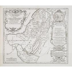
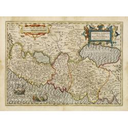
Terre de Chanaan, ou Terre promise à Abraham et à sa Posterité . . . .
Two maps on one sheet. With a map of Palestine and a map of the Near Eas with a title cartouche "Carte des voiages d'Abraham faits par l'ordre de Dieu, en Asie et en...
Place & Date: Paris, ca. 1797
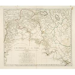
L'Euphrate et Le Tigre.
A detailed map prepared by D'Anville. Covering the Syrian Desert, Lebanon, and the mouth of the Tigris in the Persian Gulf. Including Babylon, Tripoli, etc.
- $150 / ≈ €140
Place & Date: Nuremberg, 1783
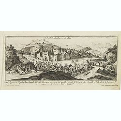
Het dal Terebinthus in Arabia.
Magnificent bird's eye- of Terebinthus north of Hebron. Etched by Gaspar Bouttats (1640-1695).The Antwerp-based publisher Jacques Peeters published ca. 1690 a series of p...
- $150 / ≈ €140
Place & Date: Antwerp, c.1690
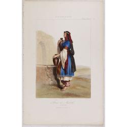
FEMME DE NAZARETH (Palestine). Costumes Syriens 10.
A beautiful hand colored lithograph of a woman from Nazareth (Palestine) published in the French work "Galerie Royale de Costumes peints d´après nature par divers ...
- $300 / ≈ €281
Place & Date: Paris, Chez Aubert & Cie., 1842-1848
Quinta Etas Mundi. Folium. LXVI. (Visionary Temple of Ezekiel.)
The Latin text page is illustrated with recto and verso depictions of the visionary Temple of Ezekiel. Kings.Page from the richest illustrated Incunable, the famous: Chro...
- $200 / ≈ €187
Place & Date: Nuremberg, 12 July 1493
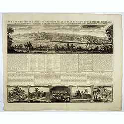
Vue & discription de la Ville de Jerusalem..avec Tombeaux..
This copper-engraving shows a panoramic view of Jerusalem, two insets of mount "Liban" and three insets of the tombs De Zacharie, Des Rois, and D'Absalom.Zachar...
- $400 / ≈ €374
Place & Date: Amsterdam, 1728
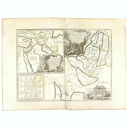
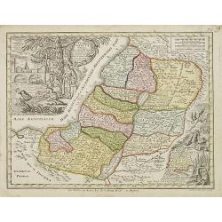
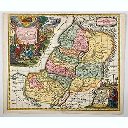
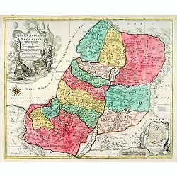
Het Heylige Land verdeeld in de twaalf stammen Israels ..
A fine map of the Holy Land depicting the tribes of Israel. A fine cartouche with Jesus preaching and healing. The scales with a cartographer and his pupil.
- $300 / ≈ €281
Place & Date: Amsterdam, 1700
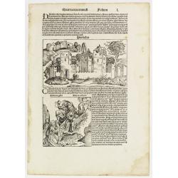
Quarta etas mundi Folium L. ( Jericho, The Prophet Elijah Ascending to Heaven...)
Panoramic view of Jericho. An imaginary view: however, the earliest obtainable view of this period. Underneath The Prophet Elijah Ascending to Heaven in a Fiery Chariot, ...
- $350 / ≈ €328
Place & Date: Nuremberg, 12 July 1493
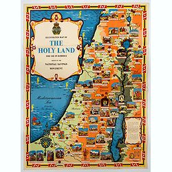
Ilustrated Map of The Holy Land for use in schools…
A visually striking and impressive pictorial map of The Holy Land, as issued by the National Savings Movement / Committee during the 1950s. In the upper left quadrant of...
- $250 / ≈ €234
Place & Date: London, ca. 1950
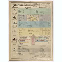
Histoire Sainte, 1840, Cours encyclopédiques - 28e Année - Méthode de Mr Colart . . .
Fine genealogic sheet for educational purpose, about Jewish history. From Adam to Cyrus. In top a map of "Palestine ou Terre Promise en 12 Tribes" 135 x 70mm.
- $350 / ≈ €328
Place & Date: Paris, 1840
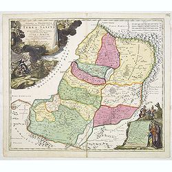
Carte de la Terre Sainte Divisée dans toutes ses parties. . .
A finely engraved map depicting the division of the Holy Land into twelve tribes.Zacharie Chatelain (d.1723) was the father of Henri Abraham (1684-1743) and Zacharie Juni...
- $350 / ≈ €328
Place & Date: Amsterdam, 1728
40 De gelegentheyt van ’t Paradys en ’ t Landt Canaan.
Bottom right:' t Amsterdam uytgegeven door Cornelis Dankerts voor aen op de Nieuwendijck in den Atlas met Previlegie.This Cornelis Danckerts ( the spelling of his name di...
- $250 / ≈ €234
Place & Date: Amsterdam, 1720
Terre Sainte jadis Terre Promise ou Palestine.
Rare map of the Holy Land published by Jollain in 1667. Published in "Trésor Des Cartes Geographiques Des Principaux Estats de Lunivers".This atlas is based up...
- $300 / ≈ €281
Place & Date: Paris, 1667
Afbeelding van all de Landen gelegen tusschen de Middellandsche, Zwarte, Caspische, Persische en Rode Zeën.
A map of the Near East, with an oversized Cyprus. From a Dutch bible published by Nicolaas Goetzee. Willem Albert Bachiene (1712-1783), Dutch geographer in Maastricht. Mo...
- $300 / ≈ €281
Place & Date: Gorichem, Nicolaas Goetzee, 1748
Terra Sancta vocata quae olim XII tribus . . .
Miniature map of the Holy Land, among the 12 Tribes and divided into 6 provinces. In the upper left near the title cartouche Pharaoh''s daughter discovers Moses in the Ri...
- $300 / ≈ €281
Place & Date: Augsburg, J.M.Will, 1778

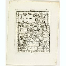
Tabula Asiae IIII. (Cyprus, Holy Land, Syria, Jordan, Iraq)
Gastaldi's map showing Cyprus, the Holy Land, Syria, Jordan and Iraq, based upon Ptolemy's map It is one of the earliest obtainable maps of the region.From Giacomo Gastal...
- $350 / ≈ €328
Place & Date: Venice, 1548
![[Map of the Holy Land, including Cyprus]](/uploads/cache/33436-250x250.jpg)
[Map of the Holy Land, including Cyprus]
Attractive full page longitudinal map of Palestine, Syria and Cyprus, cut by Hans Rudolf Manuel Deutsch. The shore line running from Southern Anatolia to the Nile Delta. ...
Place & Date: Basle, 1550-1580
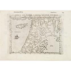
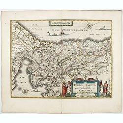
Soria et Terra Santa nuova tavola.
Early map of this classical map of the Holy Land, including Cyprus, prepared by Giovanni Botero. The copper plate was however later used by Giuseppe Rosaccio's expended e...
- $500 / ≈ €468
Place & Date: Venice, 1598
Het Beloofde Landt Canaan door wandelt onser Saligmaecker Jesu Christo neffens sijne Apostelen.
Fine map of the Land of Canaan or the Promised Land with north oriented to right. Large decorative title cartouche at bottom surrounded by vignettes depicting birth, deat...
Place & Date: Amsterdam, 1688
La Judée ou Palestine, sous le roi Herodes surnommé le grand, où sont la Judée, la Samarie, la Galilée, la Thrachonitide ou Iturée, la Perée et l'Idumée pour le nouveau testament et pour les livres des Machabées. . .
Scarce map of Palestine. Published by Pierre Moullart-Sanson, who was the grandson of Nicolas the elder.This is the uncommon third state. For the second state a large tit...
- $350 / ≈ €328
Place & Date: Paris, ca.1750
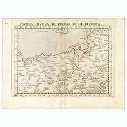
Tavola nuova di Prussia et di Livonia.
Uncommon first edition of this early map of the region from Pomerania to Livonia, includes a portion of Estonia, and coastal detail on the Baltic Sea with a small section...
- $400 / ≈ €374
Place & Date: Venice, Vincenzo Valgrisi, 1561
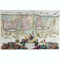
Le Païs de Canaan traversé par notre seigneur Iesus Christ et les apostres.
Fine map of Israel with north oriented to right. Large decorative title cartouche at bottom surrounded by vignettes depicting the life of Christ. At top, putti hold banne...
- $450 / ≈ €421
Place & Date: Amsterdam, 1663
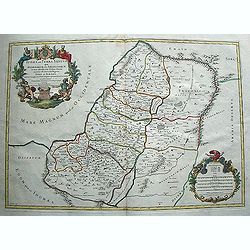
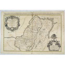
Carte de la Terre Sainte Divisée dans toutes ses. . .
A finely engraved map depicting the division of the Holy Land into twelve tribes.
- $400 / ≈ €374
Place & Date: Amsterdam, 1728
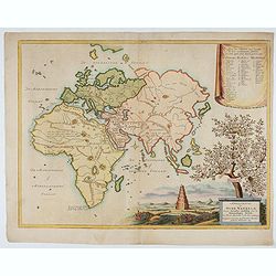
Afbeeldinge der Oude Waereld; Benevens Derzelver Verdeling Onder de Nakomelingen Noachs.
An interesting and uncommon map of the 'Old World' showing the continents of Europe, Asia, and Africa divided among Noah's sons. Engraved by Jan van Jagen and published i...
Place & Date: Amsterdam, 1749
IUDAEA seu PALAESTINA... TERRA SANCTA... IUDA et ISRAEL
Map of Palestine divided among the Tribes, drawn by Homann after Guillaume Sanson. The shoreline runs from Sidon as far as Rinocorura. The Kishon River is shown as connec...
- $500 / ≈ €468
Place & Date: Nuremberg, 1707
Jerusalem.
On verso an early representation of Jerusalem (102x79mm) and underneath a temple and a church.From a German text edition of his Cosmographia , that great compendium of Re...
- $500 / ≈ €468
Place & Date: Basle, 1550-1580
Regio Canaan seu Terra Promissionis postra Judeae vel Palaestina nominata hodiae Terra Sancta. . .
A striking and beautiful map of The Holy Land and Judea divided up into the twelve tribes. These are easily distinguished by the use of bold, rich period wash colour. Wit...
- $600 / ≈ €561
Place & Date: Augsburg, ca 1734
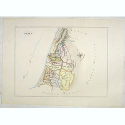
Giudea (Tav I)
A large-format map of the Holy Land with its dioceses. The map is finely engraved and beautifully colored and was prepared by Girolamo Petri, a lawyer who served as a sen...
- $600 / ≈ €561
Place & Date: Rome, 1858
Iudaea seu Terra Sancta quae Hebraeorum sive Israelitarum. . .
Map of the Holy Land divided among the Tribes as well as in two kingdoms, Judah and Israel. The title cartouche shows Moses and Aaron. Lower right corner cartouche, which...
- $600 / ≈ €561
Place & Date: Paris, 1709
Terrae Sanctae Tabula e Scripturae Sacrae, Flavii Josephi, Eusebii et Divi Hieronymi . . . Delineata.
A very fine map centered on Palestine on both sides of the Jordan, divided among the Tribes and according to the division into provinces of the Roman time.Very nice title...
- $600 / ≈ €561
Place & Date: Paris/ Bordeaux, 1771-1783
Terra Sancta quae in Sacris Terra Promissionis ol: Palestina.
Map of Palestine on both sides of the Jordan, the shore line running from Berithus (Beirut) to Gaza.Oriented to the east.Largely based on Ortelius 1584 map. In lower left...
- $675 / ≈ €632
Place & Date: Amsterdam, 1606
Terra Sancta A Petro Laicstain perlustrata, et ab eius ore
Oriented to the east. Shows the shoreline from Beirut to Gaza. P. Laicksteen, a Dutch astronomer… collected topographic material on Palestine during his stay there in 1...
Place & Date: Antwerp, 1598

Jerusalem.
Very rare view of Jerusalem published in the first edition of "Viaggio da Venetia, a Costantinopoli. Per Mare, e per Terra, & infieme quello di Terra Santa. Da G...
Place & Date: Venice, Giacomo Franco, 1598
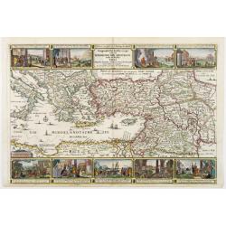
Geographische Beschryvinge van de wandeling der Apostelen. . .
Finely engraved detailed map covering the whole of the eastern Mediterranean. Showing the travels of the apostles after the death of Christ, with episodes from the life o...
- $750 / ≈ €702
Place & Date: Amsterdam, 1648
JUDEA seu TERRA SANCTA quae HEBRAEORUM sive ISRAELITARUM in suas duodecim Tribus divisa secretis ab invicem Regnis IUDA et ISRAEL expressis in super sex ultimi temporis eiusdem Terrae Provincijs. . .
Map of Palestine, showing the location of the various tribes, in two kingdoms, Judah and Israel as well as in six provinces. Shows Palestine on both sides of the Jordan, ...
- $750 / ≈ €702
Place & Date: Amsterdam, 1720
Terra Sancta sive Palaestina. . .
Map of Palestine divided among the Tribes on both sides of Jordan and into Kingdoms of Judah and Israel. Cartouche at bottom right features a small map of the Exodus.T.C....
- $750 / ≈ €702
Place & Date: Augsbourg, 1770
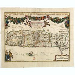
Situs Terrae Promissionis.
Superb map with north oriented to the left. It is finely engraved with numerous biblical scenes including the Exodus, the wandering of the Children of Israel, and several...
- $500 / ≈ €468
Place & Date: Amsterdam, 1665
Terra Sancta que in Sacris Terra Promissionis ol: Palestina.
This map of Palestine extending from the Lebanon mountains to the Dead Sea is based on the large map by P.Laicksteen and Chr.'s-Grooten in the latter part of the sixteent...
- $675 / ≈ €632
Place & Date: Amsterdam, 1630
-250x250.jpg)
Israel.
Decorative poster advertising flights to Israel made by Georges Mathieu. The poster is one of a series of 15 composed of posters of Greece, Israel, Germany, Great Britai...
Place & Date: Paris, 1967
Novissima totius Terrae Sanctae sive promissionis. . .
Engraved by J.B.Homann and published by David Funck. One of the very few maps engraved by Johan Baptist Homann, signed lower right.A rare map of the Holy Land, orientated...
- $950 / ≈ €889
Place & Date: Nuremberg, 1742
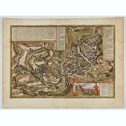
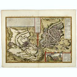
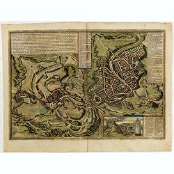
Hierosolymia, Clarissima totius Orientis civitas. . .
Two bird's eye perspectives on one sheet. The left plan shows ancient Jerusalem at the time of Christ. A contemporary view of Jerusalem appears to the right with an attra...
Place & Date: Cologne, 1582

Kaart van Palestina voor oud- en nieuw testament behorend bij de weg met en naar Christus door Fr. M. Bellarminus.
Original vintage illustrated map wall map sized poster (166 x 118cm) of Palestine in the time of Christ featuring a map of the old and new testament of the Bible from The...
Place & Date: Utrecht, Sint Gregoriushuis, 1948
Terra Sancta que in Sacris Terra Promissionis ol: Palestina
This map of Palestine extending from the Lebanon mountains to the Dead Sea is based on the large map by P.Laicksteen and Chr.'s-Grooten in the latter part of the sixteent...
- $900 / ≈ €842
Place & Date: Amsterdam, 1630
De gelegenheyt van t'paradys ende t'landt van Canaan..
Very attractive map, showing the location of Paradise. Two vignettes depict the Temptation of Adam and Eve, and their Expulsion from the Garden of Eden. Nicolaes Visscher...
Place & Date: Amsterdam, 1664
Judaea seu Palaestina .. Terra Sancta. . .
Johann Baptist Homann's well-engraved map has two large decorative cartouches. Upper left Moses receiving the Tables. Lower right Moses and Aaron pointing at a map showin...
- $1000 / ≈ €936
Place & Date: Nuremberg, 1744
Hierosolymia, Clarissima totius Orientis civitas. . .
Two bird's eye perspectives on one sheet. The left plan shows ancient Jerusalem at the time of Christ.A contemporary view of Jerusalem appears to the right with an attrac...
- $900 / ≈ €842
Place & Date: Cologne, 1582
Iudaea seu terrasancta quae Hebraeorum sive Israelitarum. . .
Fine map of the Holy Land with a decorative title and scale cartouche.Alexis-Hubert Jaillot (1632-1712), was a French cartographer. He joined the Sanson heirs and redrew ...
- $1100 / ≈ €1029
Place & Date: Amsterdam, 1692

Jerusalem.
Engraved by Bastiaan Stoopendaal from Juan Bautista Villapando's imaginary town-plan of Jerusalem. This bird's-eye view is surrounded by 12 scenes, views and portraits of...
Place & Date: Amsterdam, 1682
TERRA SANCTA quae in Sacris Terra Promissionis...
The Holy Land, Promised Land or Palestine. Oriented to the west. Shows the entire Palestine on both sides of the Jordan, the shore line running from Tripoli as far as the...
- $900 / ≈ €842
Place & Date: Amsterdam, 1644
Hierosolymia, Clarissima totius Orientis civitas. . .
Two bird's eye perspectives on one sheet. The left plan shows ancient Jerusalem at the time of Christ. The view on the left also portrays the procession of Jesus to Golgo...
- $1200 / ≈ €1123
Place & Date: Cologne, 1575

Terrae Yemen Maxima Pars, seu Imperii Imami, Principatus Kaukeban nec non ditionum Haschid u Bekil, Nehhm, Chaulan, Abu Arisch et Aden Tabula ...
South-west Arabia, with the Saudi Arabian city of Jizan south to Aden. With a fine title, cartouche. Based on a map by Carsten Niebuhr. With the name Sinus Arabicus Mare ...
Place & Date: Augsbourg, 1774
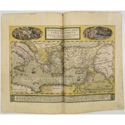
Peregrinationis Divi Pauli Typus..
A splendid map depicting the travels of Paulus. With two fine scenes in top. Showing the countries along the Mediterranean, including Cyprus and Italy. A first edition wi...
- $1500 / ≈ €1404
Place & Date: Antwerp, 1584

Quella Tavola E l'Antica Siria ch'Era destinta in dodici . . .
Very rare view of Holy Land published in the first edition of "Viaggio da Venetia, a Costantinopoli. Per Mare, e per Terra, & infieme quello di Terra Santa. Da G...
Place & Date: Venice, Giacomo Franco, 1598

Chorographia Terrae Sanctae in Angustiorem. . .
Rare. Large visually rich map decorated with illustrations of the sacred objects and places of Judaism. In the bottom center is a plan of ancient Jerusalem, and the route...
Place & Date: Amsterdam, ca. 1700
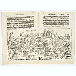
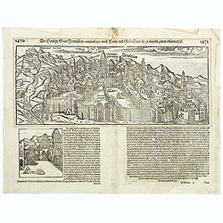
Destruccio Iherosolime.
The view shows the destruction of Jerusalem. Major points in the city are identified with Latin notations. Of interest, in the upper left of the image are two figures...
- $2000 / ≈ €1871
Place & Date: Nuremberg, 12 July 1493