Browse Listings in America > North America > Virginia / Maryland / Carolina / Georgia
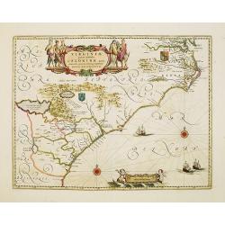
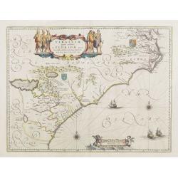
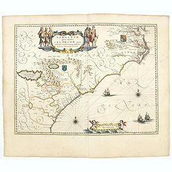
Virginiae Partis Australis, et Floridae Partis Orientalis.
Blaeu based this map on the Mercator-Hondius of 1606. A number of geographical improvements, however were incorporated, although two large fictions lakes accompanied by e...
- $1800 / ≈ €1684
Place & Date: Amsterdam, 1640
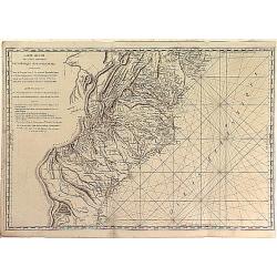
Carte Réduite des Côtes Orientales Del'Amérique Septentrionale Contenant partie du Nouveau Jersey, la Pen-sylvanie, le Mary-land, la Virginie, la Caroline Septentrionale, la Caroline Méridionale et la Georgie. . .
Scarce Rome edition of an French map made expressly for use of the French Navy during the American Revolution. Covering the area of Maryland, North and South Virginia. Ph...
- $900 / ≈ €842
Place & Date: Genova, Yves Gravier, c.1800

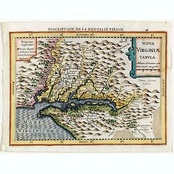
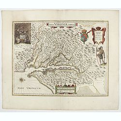
Nova Virginiae tabula.
A fine example of Blaeu's map of Virginia and the Chesapeake region is based on the first state of Smith's map, 1612, and is slightly larger and more expertly engraved.Th...
Place & Date: Amsterdam, 1635/1660
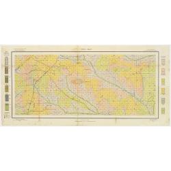
Soil map - South Carolina Campobello Sheet.
Early color lithographed soil map by Julius Bien & Co. in New York for the Department of Agriculture. Legends at the side give detail on soil type, etc. They also inc...
- $50 / ≈ €47
Place & Date: New York, 1903
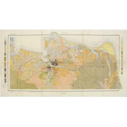
Soil map - Virginia Norfolk Sheet.
Soil map printed by Julius Bien & Co. in New York for the Department of Agriculture. The map gives great detail of the area centered on Norfolk, Potsmouth, Chesapeake...
- $50 / ≈ €47
Place & Date: New York 1903
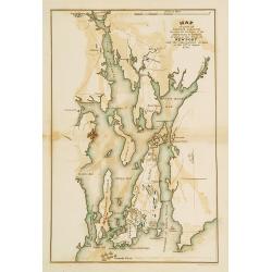
Plan of part of RHODE ISLAND..
Map showing vicinity around New Port. It Shows American and British armies at the siege of Newport and the subsequent action on the 29th of August 1778. Depicting the Fre...
- $100 / ≈ €94
Place & Date: Philadelphia, 1806 or 1834
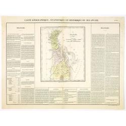
Carte Géographique .. Delaware.
Detailed map of Delaware. From J.A. Buchon, Atlas Gégraphique Statistique, historique et chronologique des deux Ameriques et des isles adjacentes, traduit de l'atlas ex�...
- $300 / ≈ €281
Place & Date: Paris, 1825

Nova Virginia Tabula.
A beautifully engraved map, derived from the highly influential map by Captain John Smith in 1612, showing Chesapeake Bay and the surrounding area. The decoration of this...
- $1250 / ≈ €1170
Place & Date: Amsterdam, J.Meurs, 1671

Virginiae Partis Australis, et Floridae Partis Orientalis.
Blaeu based this map on the Mercator-Hondius of 1606. A number of geographical improvements, however were incorporated, although two large fictions lakes accompanied by e...
Place & Date: Amsterdam, 1640

Carte Réduite Des Côtes Orientales De L' Amérique Septentrionale Contenant Partie du Nouveau Jersey.. Virginie.. Georgie..
Uncommon chart that extends from Delaware Bay and Philadelphia south through much of Georgia to Island Amelia and St. Johns River. Fleur-de-lis and rhumb lines fill the s...
Place & Date: Paris, 1778
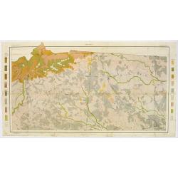
![[Soil map] Virginia-Maryland-West Virginia, Leesburg sheet.](/uploads/cache/23257-250x250.jpg)
[Soil map] Virginia-Maryland-West Virginia, Leesburg sheet.
Early color lithographed soil map by Julius Bien & Co. in New York for Department of Agriculture. Legends at side give detail on soil type, etc. They also include int...
Place & Date: New York, 1903
Soil map - Georgia, Fort Valley sheet.
Early color lithographed soil map by Julius Bien & Co. in New York for Department of Agriculture. Legends at side give detail on soil type, etc. They also include in...
- $50 / ≈ €47
Place & Date: New York, 1903
Virginiae Partis Australis, et Floridae Partis Orientalis.
Blaeu based this map on the Mercator-Hondius of 1606. A number of geographical improvements, however were incorporated, although two large fictions lakes accompanied by e...
- $1500 / ≈ €1404
Place & Date: Amsterdam, 1658
Virginiae Partis Australis, et Floridae Partis Orientalis.
Blaeu based this map on the Mercator-Hondius of 1606. A number of geographical improvements, however were incorporated, although two large fictions lakes accompanied by e...
Place & Date: Amsterdam, 1640
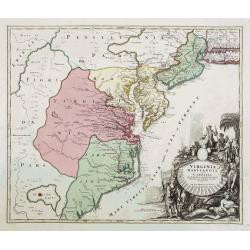
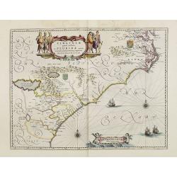
Virginia Marylandia et Carolina..
An attractive and detailed map, covering the coastline from Long Island in the north to just south of Cape Feare in Carolina, with the large fictitious Apalache Lacus in ...
- $2000 / ≈ €1871
Place & Date: Augsburg, 1740

P.les de Virginie.
Attractive copper engraving, depicting a couple of native people of Florida.From the French text edition of Description d'Univers, 1683. by Allain Manneson Mallet (1630-1...
- $110 / ≈ €103
Place & Date: Paris, 1683
![[View of the Potomac River from Mount Vernon ].](/uploads/cache/27550-250x250.jpg)
[View of the Potomac River from Mount Vernon ].
Aquatint depicting a view of the Potomac River from Mount Vernon engraved by Fumagalli. Plate N°46.From Giulio Ferrario's work Le Costume Ancien et Moderne ou Histoire d...
Place & Date: Milan, 1827
![[Slave labor on an indigo plantation ].](/uploads/cache/27564-250x250.jpg)
[Slave labor on an indigo plantation ].
Aquatint depicting slave labor on an indigo plantation engraved by Fumagalli. Plate N°51.From Giulio Ferrario's work Le Costume Ancien et Moderne ou Histoire du gouverne...
Place & Date: Milan, 1827
![[Slave labor on a Tobacco plantation ].](/uploads/cache/27565-250x250.jpg)
[Slave labor on a Tobacco plantation ].
Aquatint depicting slave labor on an tobacco plantation engraved by Biasioli. Plate N°50.From Giulio Ferrario's work Le Costume Ancien et Moderne ou Histoire du gouverne...
Place & Date: Milan, 1827
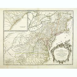
Partie De L'Amerique Septentrionale... Le Cours De L'Ohio, La N.lle Angleterre, a Nlle York, le New Jersey , La Pensyvanie, Le Maryland, Le Virginie, La Carolina...1755
From the Atlas Universel , a detailed map extending the length of the east coast from Penobscot Bay to Cape Fear and, in an inset, from Cape Fear to Fort St.Georges.This ...
- $750 / ≈ €702
Place & Date: Paris, 1768

Virginie, Grande Region l'Amerique Septentrionale...
Pierre van der Aa used the old copper plate of Meurs and re-did the engraving, changed the large pictorial cartouche, a new scale of German and French leagues is provided...
Place & Date: Amsterdam, 1729
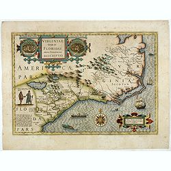
Virginiae item et Floridae. . .
Cummings describes it as one of the most beautifully executed maps ever made of the Southeast. In detail and in general conception it surpasses all earlier maps of the re...
- $2500 / ≈ €2339
Place & Date: Amsterdam, 1630
Virginiae item et Floridae . . .
Map of Virginia from the rare Cloppenburg edition slightly larger format and more scarce edition of the Mercator/Hondius "Atlas Minor". Engraved by Pieter Van D...
- $750 / ≈ €702
Place & Date: Amsterdam, 1630
![[The manner of making their boats.]](/uploads/cache/40467-250x250.jpg)
[The manner of making their boats.]
The manner of making boats in Virginia is wonderful to behold. They were able to do so without using any iron tool at all. First they chose a tall tree, wide enough for a...
Place & Date: Frankfurt, M.Merian, 1633

Nova Virginiae Tabula.
A fine example of Blaeu's map of Virginia and the Chesapeake region is based on the first state of Smith's map, 1612, and is slightly larger and more expertly engraved.Th...
Place & Date: Amsterdam, 1640
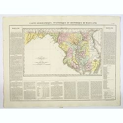
Carte Geographique, Statistique ey Historique du Maryland.
A lovely, detailed map of Maryland, from Buchon's, Atlas Gégraphique Statistique, historique et chronologique des deux Ameriques et des isles adjacentes, traduit de l'at...
- $100 / ≈ €94
Place & Date: Paris, 1825
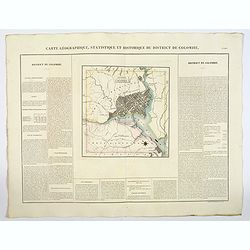
Carte Geographique, Statistique ey Historique du District de Colombie.
A lovely, detailed map of the District of Columbia, (Washington) from Buchon's, Atlas Gégraphique Statistique, historique et chronologique des deux Ameriques et des isle...
- $100 / ≈ €94
Place & Date: Paris, 1825
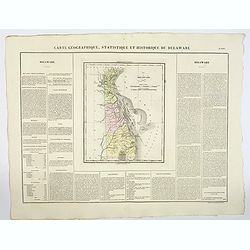
Carte Geographique, Statistique et Historique du Delaware.
A nice detailed map of Delaware, from Buchon's Atlas Gégraphique Statistique, historique et chronologique des deux Ameriques et des isles adjacentes, traduit de l'atlas ...
- $100 / ≈ €94
Place & Date: Paris, 1825
Virginiae Partis Australis, et Floridae Partis Orientalis.
Blaeu based this map on the Mercator-Hondius of 1606. A number of geographical improvements, however were incorporated, although two large fictions lakes accompanied by e...
- $2000 / ≈ €1871
Place & Date: Amsterdam, 1644
Nova Virginiae Tabula.
The map is based on the first state of Smith's map, 1612, and is slightly larger and more expertly engraved. In 1629 the Hondius plate was purchased by Blaeu who deleted ...
Place & Date: Amsterdam, 1644
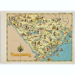
South Carolina.
A fun, humorous, whimsical map of South Carolina by Ruth Taylor White. With vibrant colors.The state is filled with delightful cartoonish characters, some pursuing assort...
- $125 / ≈ €117
Place & Date: Boston, ca 1935

Carolinae Floridae nec non Insularum Bahamensium cum partibus adjacentibus delinatio ad Exemplar Londinense in lucem edita . . . Ao. 1755.
The German edition of this map of Carolina, Florida, and the Bahama Islands in full original colors. Published in Seligmann's "Sammlung verschiedener auslaendischer ...
Place & Date: Nuremberg, 1755
![[The French left in Fort Charles suffer the scarcity of provisions.]](/uploads/cache/48529-250x250.jpg)
[The French left in Fort Charles suffer the scarcity of provisions.]
An Indian town visited by the French of Charlesfort in search for food. After a drawing by LeMoyne. Charlesfort-Santa Elena is on what is now Parris Island, South Carolin...
- $400 / ≈ €374
Place & Date: Frankfurt, 1594
![Arcis Carolinae delineatio [Jacksonville]](/uploads/cache/48530-250x250.jpg)
Arcis Carolinae delineatio [Jacksonville]
Depicting Fort Caroline in Jacksonville, Florida. A French expedition, organized by Protestant leader Admiral Gaspard de Coligny and led by the French Explorer Jean Ribau...
- $400 / ≈ €374
Place & Date: Frankfurt, 1594
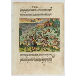
Cacodemon attacking the savages.
Cacodemon ("evil spirit") attacking the savages. Read more about "Les Grand Voyages" by Theodore De Bry [+]
- $200 / ≈ €187
Place & Date: Frankfurt, 1594