
Carte générale de l' Amérique divisée en ses principaux états . . .
Map of North and South America. By C. F. Delamarche, successor of Robert de Vaugondy, Geographer. Descriptive text to the left.
Place & Date: Paris, 1820
![[ North and South America with telegraph cables, with Ottoman script]](/uploads/cache/44330-250x250.jpg)
[ North and South America with telegraph cables, with Ottoman script]
Postcard size map showing North and South America with telegraph cables. The map is in Ottoman Arabic-script prepared by Mehmet EŞREF in a small atlas : عمومولا�...
- $190 / ≈ €178
Place & Date: Istanbul, 1325 or 1909
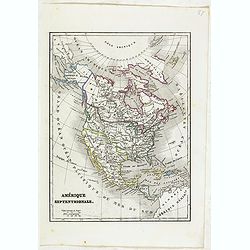
Amérique Septentrionale.
Detailed map of America, prepared by Charles V. Monin (fl.1830-1880) a French cartographer of Caen and Paris. Published in Atlas Universel de Géographie Ancienne &c ...
- $50 / ≈ €47
Place & Date: Paris, 1845

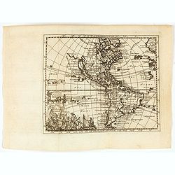
Americae Nova Tabula.
An inset shows Greenland and Iceland. Decorative elements include ships, sea monsters, and vignettes of native Americans within South America. In addition, the map is bor...
- $7500 / ≈ €7018
Place & Date: Amsterdam, 1644

Rooseveld rekende verkeerd ! De vangarmen van De Dollarpoliep worden afgesneden. . .
An remarkable Anti-American Dutch World War II propaganda poster by Lou Manche, showing an pink octopus, representing the United States, with its tentacles being cut from...
Place & Date: The Netherlands, 1942
America.
A very nice map of the American continent with California as an island and an adorned title cartouche.From Francisco Giustiniani for El Atlas abreviado o el nuevo compend...
- $300 / ≈ €281
Place & Date: Leon de Francia (Lyon), Jaime Certa, 1739
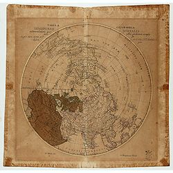
Tabula Geographica Hemisphaerii Borealis…
Polar map with a diameter of 30cm which shows the fictitious Mer de L’Ouest prominently with an extensive river system connecting it with the Great Lakes and thus formi...
- $150 / ≈ €140
Place & Date: Berlin c.1753
![[Printed on silk] Nova Totius Americae Sive Novi Orbis Tabula, Auct. Hugo Allardt.](/uploads/cache/48420-250x250.jpg)
[Printed on silk] Nova Totius Americae Sive Novi Orbis Tabula, Auct. Hugo Allardt.
Hugo Allard’s ca. 1661 map of the Americas, showing California as an island printed on silk. This separately issued map printed on paper is quite rare on the market. T...
Place & Date: Amsterdam, 1661
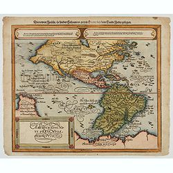
Americae Sive Novi Orbis, Nova Descriptio
Woodcut map by based on Abraham Ortelius' classic map of 1570, with the huge bulge in the southwest coastline of South America, the Ortelian western coastline of North Am...
Place & Date: Basel, ca. 1588
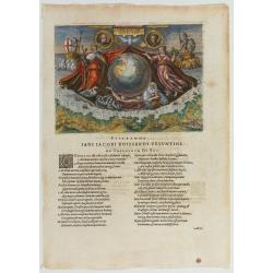
Americae Retectio (Allegory of the Discovery of America)
Allegorical scene commemorating the discovery of America. The main image shows Neptune, supporting a Globe, flanked by Flora-representing Florence, and Janus-representin...
- $1000 / ≈ €936
Place & Date: Frankfurt, 1594