
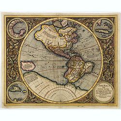
Americae Sive Novi Orbis, Nova Descriptio.
This is the second copperplate of Ortelius' map showing the western hemisphere, showing the prominent bulge in the South American coastline. An important map because of i...
Place & Date: Antwerp, 1579
Americae Sive Novi Orbis, Nova Descriptio
Woodcut map by based on Abraham Ortelius' classic map of 1570, with the huge bulge in the southwest coastline of South America, the Ortelian western coastline of North Am...
Place & Date: Basel, ca. 1588

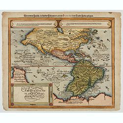
Americae Pars Magis Cognita. Chorographia nobilis & opulentae Peruanae Provinciae, atque Brasiliae, . . . MDXCII
First state. Although a map of South America it does include much of what is now the southern United States. There are two elaborate, strap-work cartouches with the one a...
Place & Date: Frankfurt, 1592
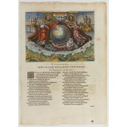
Americae Retectio (Allegory of the Discovery of America)
Allegorical scene commemorating the discovery of America. The main image shows Neptune, supporting a Globe, flanked by Flora-representing Florence, and Janus-representin...
- $1000 / ≈ €936
Place & Date: Frankfurt, 1594
![[Columbus is standing in the bow of his ship]](/uploads/cache/48524-250x250.jpg)
[Columbus is standing in the bow of his ship]
Columbus is standing in the bow of his ship, which is near the shore. He is clad in a long mantle and undercoat, while his armor lies at his feet, and his standard is flo...
- $750 / ≈ €702
Place & Date: Frankfurt, 1594
![Peruviae Auriferae Regionis Typus [with] La Florida Auctore Hieron Chiaves [with] Guastecan Reg.](/uploads/cache/60004-250x250.jpg)
Peruviae Auriferae Regionis Typus [with] La Florida Auctore Hieron Chiaves [with] Guastecan Reg.
The Chaves map of Florida is a prime example of an explorer's map since it records the recent discoveries of Cabeza de Vaca, De Soto, and Moscoso. The map revealed little...
- $2000 / ≈ €1871
Place & Date: Antwerp, 1598
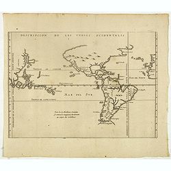
Descripcion de las Yndias Ocidentalis.
Rare early general map of America, the Pacific Ocean and the Eastern part of Asia. Showing "Meridiano de la demarcacion porla parte oscidental" - and "... ...
- $1750 / ≈ €1638
Place & Date: Amsterdam, Michel Colin, 1622
Americae sive Indiae Occidentalis.
Hessel Gerritsz. the author and probable engraver of the map had seen maps of California as an island, but he relies on the more trustworthy accounts, such as Herrera, in...
- $1000 / ≈ €936
Place & Date: Leiden, 1625
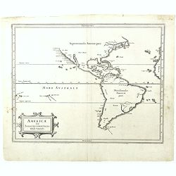
America sive India Nova.
This map was created by Michael Mercator, grandson of the great Gerard Mercator. It is the only map attributed to him. The map first appeared in 1595, one year after the ...
- $3000 / ≈ €2807
Place & Date: Amsterdam, 1630

Americae Nova Tabula.
An inset shows Greenland and Iceland. Decorative elements include ships, sea monsters, and vignettes of native Americans within South America. In addition, the map is bor...
- $7500 / ≈ €7018
Place & Date: Amsterdam, 1644