Browse Listings in America
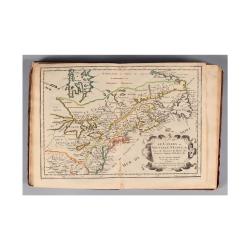
L'Amerique, en plusieurs cartes nouvelles, et exactes, &c. En divers traitez de geographie, et d'histoire. Là où sont descrits succinctement, & avec une belle Methode, & facile.
Third edition, the text and maps of which are identical to the first given in 1657. However, the dedication to Nicolas Fouquet (2 pp.), disgraced in 1661, has been delete...
- $4500 / ≈ €4211
Place & Date: Paris, 1680
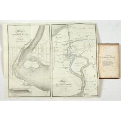
Map of Niagara Falls and viccinity.
This Fifth edition, revised and enlarged, is accompanied by 6 lithographs by Hall & Mooney depicting views of the falls and one map by H.A. Parsons entitled "Map...
- $150 / ≈ €140
Place & Date: Buffalo, 1838

Antiguedades Peruanas (Atlas).
Atlas illustrated with 60 chromolithographic and tinted lithograph plates including illustrated title page.This atlas volume was produced to accompany a landmark collabor...
- $1800 / ≈ €1684
Place & Date: Vienna (Austria), 1851
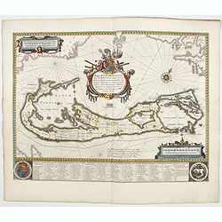
Mappa Aestivarum Insularum alias Barmudas.
Blaeu based his work on John Speed's remarkably accurate map of 1626-1627. It shows the island divided into tribes and lots, and below the map itself appear the names of ...
- $2000 / ≈ €1871
Place & Date: Amsterdam, 1644
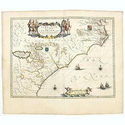
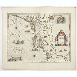
Virginiae Partis Australis, et Floridae Partis Orientalis.
Blaeu based this map on the Mercator-Hondius of 1606. A number of geographical improvements, however were incorporated, although two large fictions lakes accompanied by e...
- $2000 / ≈ €1871
Place & Date: Amsterdam, 1644
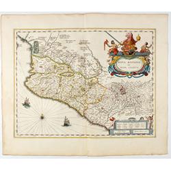
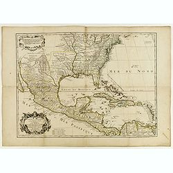
Nova Hispania et Nova Galicia.
Map of New Spain and New Galicia shows the city of Mexico situated by a large lake, as well as the location of many silver and gold mines. The map's elaborate cartouche i...
- $1400 / ≈ €1310
Place & Date: Amsterdam, 1644

Americae Nova Tabula.
An inset shows Greenland and Iceland. Decorative elements include ships, sea monsters, and vignettes of native Americans within South America. In addition, the map is bor...
- $7500 / ≈ €7018
Place & Date: Amsterdam, 1644
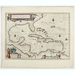
Insulae Americanae in Oceanus Septentrionali cum Terris..
General map of the West Indies extending from Virginia to the mouth of the Orinoco, and destined to be copied in various shapes by many other publishers.Title cartouche t...
- $2500 / ≈ €2339
Place & Date: Amsterdam, 1644
Nova Belgica et Anglia Nova.
Orientated with north to the right. This is one of the earliest maps to concentrate solely on this area of the colonies, excluding Virginia and the extreme north east coa...
- $4500 / ≈ €4211
Place & Date: Amsterdam, 1644
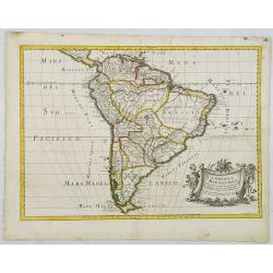
L'America Meridionale . . .
The second edition of Rossi's map of South America, based upon Sanson's map, but with revised Italian nomenclature. From his 'Mercurio Geografico...'. The engraver was G...
- $900 / ≈ €842
Place & Date: Rome, 1687
![[Lot of 5 maps] Kaart van de noord-west kust van Amerika en de noord-oost kust van Asia.](/uploads/cache/19136-250x250.jpg)
[Lot of 5 maps] Kaart van de noord-west kust van Amerika en de noord-oost kust van Asia.
- Kaart van de noord-west kust van Amerika en de noord-oost kust van Asia. Opgenoomen in de Jaaren 1778 en 1779. Captain James Cook (1728-79), explorer, circumnavigato...
Place & Date: Leiden, 1795-1803
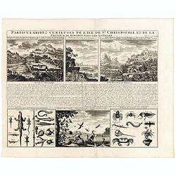
Particularitez Curieuses de l'Ile de St. Christophle et de la Province de Bemarin . . .
Six meticulously detailed and engraved scenes of the island of St. Kitts, also known as Saint Christopher, and the province of Bemarin, indigenous plants, animals, reptil...
Place & Date: Amsterdam, 1720
![[Vespucci lands on the Island of Itius.]](/uploads/cache/40486-250x250.jpg)
[Vespucci lands on the Island of Itius.]
According to the esteemed historian, Las Casas,‘Itius cannot be other than the islands we reach coming from Spain, named Guadeloupe and Dominica.When Vespucci and his S...
Place & Date: Frankfurt, M.Merian, 1633

Région arctique.
Decorative map of the North Pole, prepared by Louis Vivien de Saint-Martin (* 22. Mai 1802 in Saint-Martin de Fontenay, died 3 January 1897 in Paris). He was one of the m...
Place & Date: Paris, Hachette, 1877
![Praelium Divrnum. [Spanish fleet defeated by the Dutch] / Nocturnum Praelium [Dutch and Spanish at sea off Lima].](/uploads/cache/41087-250x250.jpg)
Praelium Divrnum. [Spanish fleet defeated by the Dutch] / Nocturnum Praelium [Dutch and Spanish at sea off Lima].
Two engravings. [498] On the evening of 17th July, 1615, Spilbergen’s Dutch fleet encountered, off the coast of Peru near Lima, the powerful fleet of the Spanish, under...
Place & Date: Frankfurt, M.Merian, 1633
![[Spilbergen's fleet visits the island of Santa Maria] / [The Dutch visit Isla Mocha].](/uploads/cache/41090-250x250.jpg)
[Spilbergen's fleet visits the island of Santa Maria] / [The Dutch visit Isla Mocha].
Two engravings. [514] On 29th May, 1615, Spilbergen’s fleet anchored further north, off an island called Santa María that was separated by a narrow stretch of water (A...
Place & Date: Frankfurt, M.Merian, 1633
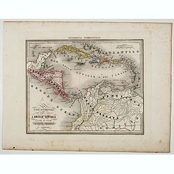
Le Indie Ocidentali ( Antille maggiori e minori, ecc) L'America Centrale . . .
Uncommon map of Central America and the Antilles prepared by Francesco Costantino Marmocchi. Above the map "Geografia Commerciale". From "Il Globo Atlante ...
Place & Date: Genova, Paolo Rivara fu Giacomo, 1858
![[Spanish take over Cusco] / [Atahualpa is garrotted].](/uploads/cache/41092-250x250.jpg)
[Spanish take over Cusco] / [Atahualpa is garrotted].
Two engravings. [486] After Atahualpa was killed, Pizarro set out with his troops to find the city of Cuzco, which he had heard was rich in gold. The journey from Cajamar...
Place & Date: Frankfurt, M.Merian, 1633
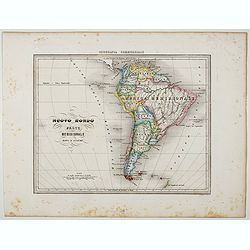
Nuovo Mondo parte Meridionale.
Uncommon map of South America prepared by Francesco Costantino Marmocchi. Above the map "Geografia Commerciale". From "Il Globo Atlante di carte Geografich...
Place & Date: Genova, Paolo Rivara fu Giacomo, 1858
![[The bloody battle at Chupas] / [Francesco Pizzaro is killed].](/uploads/cache/41093-250x250.jpg)
[The bloody battle at Chupas] / [Francesco Pizzaro is killed].
Two engravings. [492] Even before Pizarro’s death, a new royal governor, Vaca de Castro, was on his way to settle the turmoil in Peru. He refused to accept Almagro the ...
Place & Date: Frankfurt, M.Merian, 1633
![[How the Inca nobility are buried] / [Bridge of Huaynacapaco]](/uploads/cache/41094-250x250.jpg)
[How the Inca nobility are buried] / [Bridge of Huaynacapaco]
Two engravings. [470] The funeral of an Inca king was a ceremony of great splendor. After digging a large pit, the Indians would decorate the corpse with gold and silver ...
Place & Date: Frankfurt, M.Merian, 1633
![[How natives of Paria cope with illness] / Vespucci reaches Lake Maracaibo]..](/uploads/cache/41095-250x250.jpg)
[How natives of Paria cope with illness] / Vespucci reaches Lake Maracaibo]..
Two engravings. [421b] When the natives of those parts, they were bathed in a cold stream, then chased round a blazing fire until they had dried out. Then they were put t...
Place & Date: Frankfurt, M.Merian, 1633
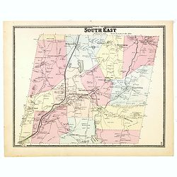
Town of South East.
Fine lithographed map of the town of South East. From : "Atlas of New York and vicinity" published by Beers, Ellis & Soule, 95 Maiden Lane, New York.The map...
Place & Date: New York, 1867
![[A prisoner of the Indians of Tupinamba, covered in feathers . . .]](/uploads/cache/41101-250x250.jpg)
[A prisoner of the Indians of Tupinamba, covered in feathers . . .]
A graphic scene of fighting and extreme violence. One man is seen covered in feathers, before being sacrificed and killed before the Brazilian tribe of Tupinamba. In 1631...
Place & Date: Frankfurt, M.Merian, 1633
![[Another Dutch fleet reaches Lima].](/uploads/cache/41117-250x250.jpg)
[Another Dutch fleet reaches Lima].
In 1624 a heavily armed Dutch fleet sailed from the Juan Fernandez Islands to Lima. The leader of the fleet, Jacob l’Hermite, was in such poor health that he had to han...
Place & Date: Frankfurt, M.Merian, 1633
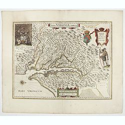
Nova Virginiae Tabula.
The map is based on the first state of Smith's map, 1612, and is slightly larger and more expertly engraved. In 1629 the Hondius plate was purchased by Blaeu who deleted ...
Place & Date: Amsterdam, 1644
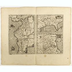
La Florida/ Peruviae Auriferae regionis Typus/ Guastecan.
The Chaves map of Florida is a prime example of an explorer's map since it records the recent discoveries of Cabeza de Vaca, De Soto, and Moscoso. The map revealed little...
Place & Date: Antwerp, 1598
Brasilia.
Fine copy of this map by Krystof Arciszewski, a Polish general who worked for the Dutch West Indian Company. The map perpetuates various myths including the Parime Lago ,...
Place & Date: Amsterdam, 1647

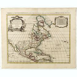
Amerique Septentrionalis..
A handsome map showing California as an island, open-ended Great Lakes and other details based mainly on Sanson. A large decorative cartouche occupies the area of the nor...
Place & Date: Paris, after1694
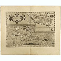
Culiacanae Americae regionis.. / Hispaniolae, Cubae..
Two virtually identically sized inset maps on one sheet, each with a decorative scroll title cartouche. Culiacanae depicts the coastal and inland western region in North ...
Place & Date: Antwerp, 1598
Carte du Mexique et des Etats Unis d'Amérique...
A later edition of De l'Isle's foundation map of 1703, widely regarded as one of the most influential maps in the history of American Cartography. This updated version of...
Place & Date: Paris, 1783
![[No title]. [Alaska-North American village with boats].](/uploads/cache/44728-250x250.jpg)
[No title]. [Alaska-North American village with boats].
Aquatint depicting a fishing scene engraved by Paolo Fumagalli, Plate N° 20 From Giulio Ferrario's work Le Costume Ancien et Moderne ou Histoire du gouvernement, de la m...
Place & Date: Milan, 1827
L'Amerique septentrionale, Dressée sur les memoires les plus recens. . .
A very detailed map extending from Hudsons Bay to Panama, and including the West Indies. The map is a later copy of Guillaume de L'Isle's foundation map of North America,...
Place & Date: Amsterdam, 1739
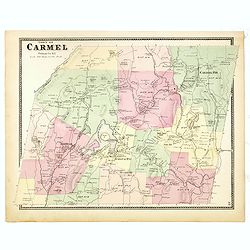
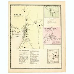
Town of Carmel.
Fine lithographed map of the town of Carmel. From : "Atlas of New York and vicinity" published by Beers, Ellis & Soule, 95 Maiden Lane, New York. The map pr...
Place & Date: New York, 1867
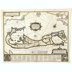
Mappa Aestivarum Insularum, alias Barmudas..
Based closely on Blaeu's map of 1630 but with a simpler centered title piece. The map includes the arms of Bermuda and England, and lists proprietors of the various tribe...
Place & Date: Amsterdam, 1645
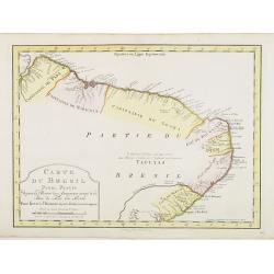
Carte du Bresil Prem. Partie..
Uncommon edition of this accurate map of eastern part of Brazil. In lower right engraved 29a.From Atlas Portatif pour servir a l''''intelligence de l''''Histoire Philosop...
Place & Date: Amsterdam, 1773
![[Native Americans of village at Nootka Sound].](/uploads/cache/44726-250x250.jpg)
[Native Americans of village at Nootka Sound].
Aquatint depicting people in a Nootka Sound village engraved by A.D Rossi, Plate N° 12 From Giulio Ferrario's work Le Costume Ancien et Moderne ou Histoire du gouverneme...
Place & Date: Milan, 1827
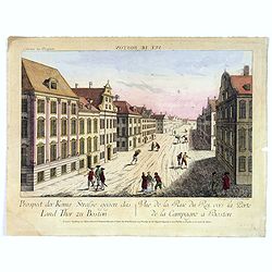
Vue de la Rue du Roi, vers la Porte de la Campagne a Boston.
A vue d'optique of the city of Boston. A view of a typical Bostonian street, with buildings opening directly onto the throughway, groups of people, gentlemen, workers and...
Place & Date: Augsburg, 1762
![[In Arabic, translates : A map of the United States of America shows its major regional ressources and its natural products]](/uploads/cache/43010-250x250.jpg)
[In Arabic, translates : A map of the United States of America shows its major regional ressources and its natural products]
Chromolithographed pictorial poster of the United States in Arabic language. Showing the United States' main products, regional resources and physical features. The map i...
Place & Date: Washington D.C., ca. 1965
Town of Carmel / Towners Station / South East Centre / Mill Town.
Fine lithographed map of the town of Carmel / Towners Station / South East Centre / Mill Town. From "Atlas of New York and vicinity" published by Beers, Ellis ...
Place & Date: New York, 1867