Browse Listings in America
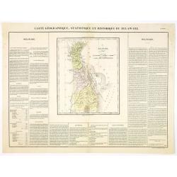
Carte Géographique .. Delaware.
Detailed map of Delaware. From J.A. Buchon, Atlas Gégraphique Statistique, historique et chronologique des deux Ameriques et des isles adjacentes, traduit de l'atlas ex�...
- $300 / ≈ €281
Place & Date: Paris, 1825

Pas kaart Van Rio Oronoque Golfo De Paria met d'Eylanden Trinidad, Tabago, Granada, Granadillos, en Bequia . . .
A highly detailed and rare sea chart of the mouth of the Orinoco River, Trinidad, Tabago, St.Vincent and neighboring islands. Oriented with north to the right by two comp...
- $900 / ≈ €842
Place & Date: Amsterdam, 1684
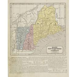
Maine, New Hampshire and Vermont.
Map of Maine, New Hampshire and Vermont.. On the verso, a world map of North and South America with its northern and southern hemispheres. From Sidney E. Morse''s: System...
- $30 / ≈ €28
Place & Date: New York, 1855
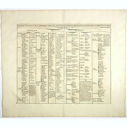
Division generale de l'Amerique dans ses principales parties pour l'intelligence de la carte de ce païs.
This folio sheet gives a breakdown of America into the northern and southern regions. These are further subdivided into the various countries and provinces.Henri Abraham ...
- $25 / ≈ €23
Place & Date: Amsterdam, 1728
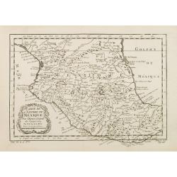
Carte de L'Empire du Mexico.
A good engraved map of Mexico, with rococo title cartouche lower left. From l'Histoire générale des voyages .
- $75 / ≈ €70
Place & Date: Paris, 1754
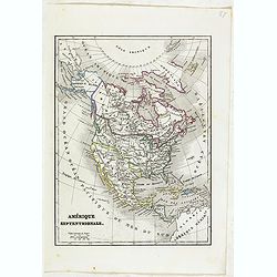
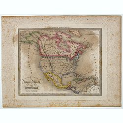
Amérique Septentrionale.
Detailed map of America, prepared by Charles V. Monin (fl.1830-1880) a French cartographer of Caen and Paris. Published in Atlas Universel de Géographie Ancienne &c ...
- $50 / ≈ €47
Place & Date: Paris, 1845
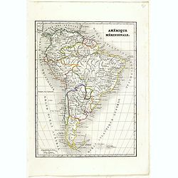
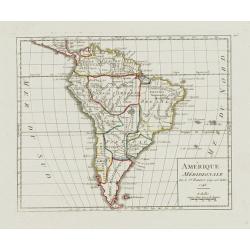
Amérique méridionale.
Detailed map of South America, prepared by Charles V. Monin (fl.1830-1880) a French cartographer of Caen and Paris. Published in Atlas Universel de Géographie Ancienne &...
- $45 / ≈ €42
Place & Date: Paris, 1845
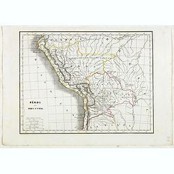
Pérou et Bolivia.
Detailed map of Peru and Bolivia, prepared by Charles V. Monin (fl.1830-1880) a French cartographer of Caen and Paris. Published in Atlas Universel de Géographie Ancienn...
- $45 / ≈ €42
Place & Date: Paris, 1845
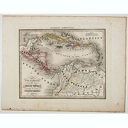
Le Indie Ocidentali ( Antille maggiori e minori, ecc) L'America Centrale . . .
Uncommon map of Central America and the Antilles prepared by Francesco Costantino Marmocchi. Above the map "Geografia Commerciale". From "Il Globo Atlante ...
Place & Date: Genova, Paolo Rivara fu Giacomo, 1858
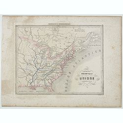
Stati Orientali della Unione Americana.
Uncommon map of Northeastern America prepared by Francesco Costantino Marmocchi. Above the map "Geografia Commerciale". From "Il Globo Atlante di carte Geo...
- $50 / ≈ €47
Place & Date: Genova, Paolo Rivara fu Giacomo, 1858
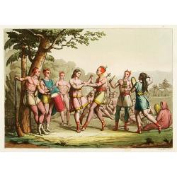
Danse d'indiens.
From Giulio Ferrario's work Le Costume ancien et moderne ou histoire du gouvernement, de la milice, de la religion, des arts, etc. published in Milan by the author betwee...
- $50 / ≈ €47
Place & Date: Milan, 1827
![[Human sacrifices by Peruvian Indians ].](/uploads/cache/27281-250x250.jpg)
[Human sacrifices by Peruvian Indians ].
Aquatint depicting human sacrifices by Peruvian Indians. Engraved by Gallina.From Giulio Ferrario's work Le Costume Ancien et Moderne ou Histoire du gouvernement, de la m...
Place & Date: Milan, 1827
Selling price: $20
Sold in 2016
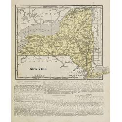
New York.
Map of New York. From Sidney E. Morse''s: System of Geography for the use of schools , published by Harper and brothers, 329 Pearl Street, New York.An 150 years old map w...
- $30 / ≈ €28
Place & Date: New York, 1855
![[The manner of making their boats.]](/uploads/cache/40467-250x250.jpg)
[The manner of making their boats.]
The manner of making boats in Virginia is wonderful to behold. They were able to do so without using any iron tool at all. First they chose a tall tree, wide enough for a...
Place & Date: Frankfurt, M.Merian, 1633
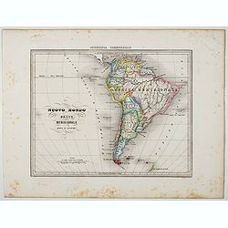
Nuovo Mondo parte Meridionale.
Uncommon map of South America prepared by Francesco Costantino Marmocchi. Above the map "Geografia Commerciale". From "Il Globo Atlante di carte Geografich...
Place & Date: Genova, Paolo Rivara fu Giacomo, 1858
Nuovo Mondo parte Settentrionale.
Uncommon map of North America prepared by Francesco Costantino Marmocchi. Above the map "Geografia Commerciale". From "Il Globo Atlante di carte Geografich...
- $50 / ≈ €47
Place & Date: Genova, Paolo Rivara fu Giacomo, 1858
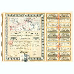
Accion de 10 pesos. No. 110,930 (Share certificate)
Beautifully engraved certificate from the "Compania Azucarera de Paraiso Novillero S.A. Republica Mexicana", share certificate No.110,930 for one share, in a $ ...
- $30 / ≈ €28
Place & Date: Paris, 1924
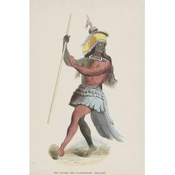
Een Danser der Californische Indiaanen.
Decorative, original hand colored, woodcut engraving illustrating a native American dancer from California.
- $35 / ≈ €33
Place & Date: Amsterdam, ca. 1860
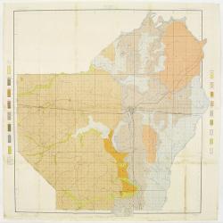
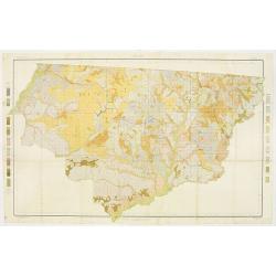
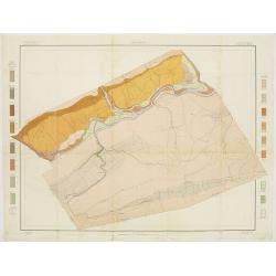
Soil map - Louisiana, Ouachita sheet.
Early color lithographed soil map by Julius Bien & Co. in New York for Department of Agriculture. Legends at side give detail on soil type, etc. They also include int...
- $40 / ≈ €37
Place & Date: New York, 1903
Amérique Méridionale.
Nice small map of South America. Dated 1748. From Atlas Portatif Universel, by Robert de Vaugondy.Page 105 outside border top right. Mary Sponberg Pedley does not mention...
- $75 / ≈ €70
Place & Date: Paris, later than 1748
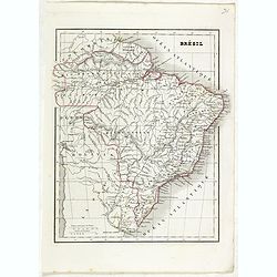
Brésil.
Detailed map of Brazil, prepared by Charles V. Monin (fl.1830-1880) a French cartographer of Caen and Paris. Published in Atlas Universel de Géographie Ancienne &c M...
- $45 / ≈ €42
Place & Date: Paris, 1845
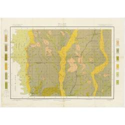
Soil map - Mississippi, McNeill sheet.
Soil map printed by Julius Bien & Co in New York for Department of Agriculture. The map is giving great detail of the area McNeill, Mississippi, in the year 1903. Soi...
- $50 / ≈ €47
Place & Date: New York, 1903
Soil map - Georgia, Fort Valley sheet.
Early color lithographed soil map by Julius Bien & Co. in New York for Department of Agriculture. Legends at side give detail on soil type, etc. They also include in...
- $50 / ≈ €47
Place & Date: New York, 1903
Soil map - Florida, Gadsden County sheet.
Early color lithographed soil map by Julius Bien & Co. in New York for the Department of Agriculture. Legends at the side give detail on soil type, etc. They also inc...
- $40 / ≈ €37
Place & Date: New York, 1903
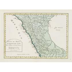
Suite de Perou Audience de Lima.
Uncommon edition of this accurate map showing the southern Peruvian coast, the ranges and villages of numerous Indian tribes are shown.FromAtlas Portatif pour servir a l'...
- $100 / ≈ €94
Place & Date: Amsterdam, 1756
![[ Local musical instruments ].](/uploads/cache/27586-250x250.jpg)
[ Local musical instruments ].
Aquatint depicting local musical instruments being played engraved by Bonatti Plate N°76.From Giulio Ferrario's work Le Costume Ancien et Moderne ou Histoire du gouverne...
- $50 / ≈ €47
Place & Date: Milan, 1827
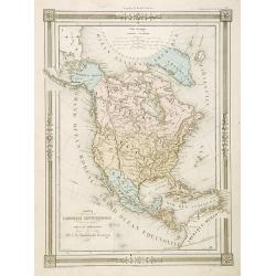
Carte L'Amérique Septentrionale..
Detailed map of North America, prepared by J.G.Barbié du Bocage.Engraved by Ch.Smith, published by Basset who was established in Paris, rue de Seine 33.
- $100 / ≈ €94
Place & Date: Paris, 1848
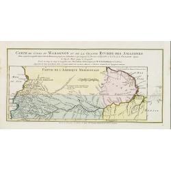
Carte du Cours du Maragnon ou .. Amazones..
Uncommon edition of this map of the river Amazon. In lower right engraved "30."From Atlas Portatif pour servir a l'intelligence de l'Histoire Philosophique et P...
- $75 / ≈ €70
Place & Date: Amsterdam, 1773
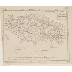
Isle de la Jamaïque.
Map of Jamaica, from Atlas de la Géographie de toutes les parties du monde.. Ouvrage destiné pour l'education, et nécessaire aux négocians, aux voyageurs, aux fonctio...
Place & Date: Paris, Prudhomme, Levrault, Debray, 1806
Selling price: $25
Sold in 2016
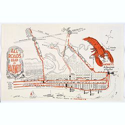
Map of Atlantic City to Hackney's Famous Garden of Sea Food . . .
A mid 1950s brochure for the famous Atlantic City Seafood Restaurant - 'Hackneys'. One side proclaims that "All Roads lead to Hackney's". It shows a nice plan o...
- $50 / ≈ €47
Place & Date: New Jersey, ca 1954
![[ The ruins of Mitla ].](/uploads/cache/27584-250x250.jpg)
[ The ruins of Mitla ].
Aquatint depicting the ruins of Mitla engraved by Fumagalli. Plate N°74.A pre-Columbian Mesoamerican building.From Giulio Ferrario's work Le Costume Ancien et Moderne ou...
- $45 / ≈ €42
Place & Date: Milan, 1827
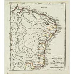
Terre de Sainte Croix, nommée à présent Bresil.
Detailed small map showing most part of the Brazilian seacoasts, from the mouth of the Amazon River as far as the island of Sao Sebastiao.From Atlas Portatif Universel, b...
- $75 / ≈ €70
Place & Date: Paris, later than 1749
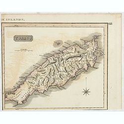
Tobago.
A delightfully detailed map of the West Indian island Tobago by John Thomson. The map displays excellent detail concerning roads, rivers, towns, bays, harbors, and other ...
- $50 / ≈ €47
Place & Date: Edenburgh, 1821
![Westelijk Halfrond. [Western hemisphere]](/uploads/cache/25524-250x250.jpg)
Westelijk Halfrond. [Western hemisphere]
Uncommon world map view of the western and eastern hemispheres of North and South America, Asia. Lithography by J.H. van Weijer, published in Atlas der geheele Aarde [?] ...
- $50 / ≈ €47
Place & Date: Groningen, ca. 1860
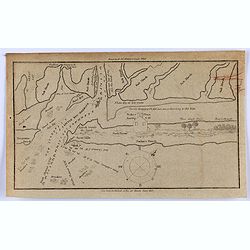
Little Egg Harbour.
A small sea chart showing Little Egg Harbour east of Tucker's Island. This map was published in the “American Coast Pilot”, a detailed guide to harbors, capes and hea...
- $50 / ≈ €47
Place & Date: New York, 1817
![[The ruins of Mitla ].](/uploads/cache/27585-250x250.jpg)
[The ruins of Mitla ].
Aquatint depicting the ruins of Mitla engraved by Fumagalli. Plate N°75.A pre-Columbian Mesoamerican building.From Giulio Ferrario's work Le Costume Ancien et Moderne ou...
- $60 / ≈ €56
Place & Date: Milan, 1827
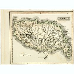
Grenada.
A delightfully detailed map the West Indian island Grenada by John Thomson. The map displays excellent detail concerning roads, rivers, towns, bays, harbours and other in...
- $50 / ≈ €47
Place & Date: Edenburgh, 1821
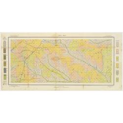
Soil map - Pennsylvania, Lockhaven sheet.
Early color lithographed soil map by Julius Bien & Co. in New York for Department of Agriculture. Legends at side give detail on soil type, etc. They also include int...
- $50 / ≈ €47
Place & Date: New York, 1903
![[Spanish Sheppard's in Paraguay ].](/uploads/cache/27290-250x250.jpg)
[Spanish Sheppard's in Paraguay ].
Aquatint depicting Spanish Sheppard's in Paraguay.Engraved by Gallina.From Giulio Ferrario's work Le Costume Ancien et Moderne ou Histoire du gouvernement, de la milice, ...
- $50 / ≈ €47
Place & Date: Milan, 1827
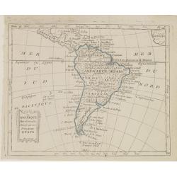
L'Amérique Méridionale, Divisée en ses Principaux Etats.
Map of South America, from Atlas de la Géographie de toutes les parties du monde .. Ouvrage destiné pour l'education, et nécessaire aux négocians, aux voyageurs, aux ...
Place & Date: Paris, Prudhomme, Levrault, Debray, 1806