Browse Listings in Africa > North Africa
![Carthage, etc. [Foliu XL ]](/uploads/cache/26122-250x250.jpg)
Carthage, etc. [Foliu XL ]
VERSO: Portraits of scholars, and an imaginary view on Carthage in Tunisia (12x17cm.) Page from the famous Liber chronicarum of Hartmann-Schedel 1493, the first and Latin...
Place & Date: Nuremberg 12 July 1493

Paskaart van de kust van Maroca beginnende van Larache tot aan C. Cantin. . .
A nautical sea chart of the coast of Morocco. Insert at top right: 'Nieuwe Afbeelding van de Rivier Rio Rebata in 't Groot".Bottom right: chart number '32'. Compass ...
Place & Date: Amsterdam, ca.1682
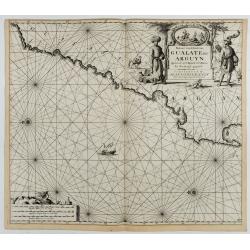
Paskaart van de Kuste van, Gualate en Arguyn. Beginnende van C. Bajador tot C. Blanco. . .
A nautical showing the northwestern coast of Africa, along Western Sahara from Cape Bojador to Cape Blanc. Ornate title cartouche in top right corner shows two main figur...
Place & Date: Amsterdam, ca.1682
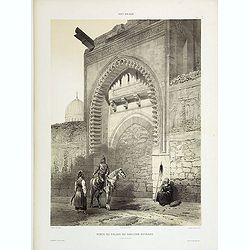
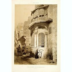
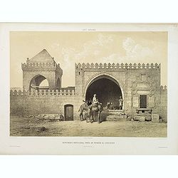
Porte du Palais du Soultan Beybars. (XIIIe. siècle)
Highly decorative lithography by Ch. Fichot, showing the walled-up entrance of Sultan Beybars' palace. From the author's "L'Art Arabe d'après les monuments du Kaire...
Place & Date: Paris, 1877
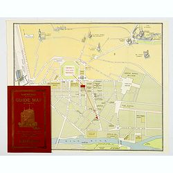
Souvenir Guide Map of Cairo.
A lovely small colored plan of central Cairo, published by Groppi in Cairo. Plan is housed within the original red and gold printed paper covers, with advertisements for ...
- $200 / ≈ €187
Place & Date: Cairo, 1920-1950
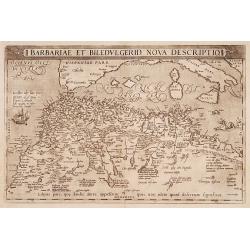
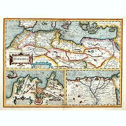
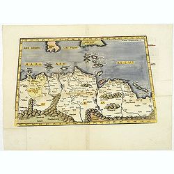
Barbariae et Biledulgerid, nova descriptio.
North-West Africa. Koeman speculated: In view of the important trading relationship between Antwerp and Africa, it is not impossible that the original was a manuscript ma...
- $300 / ≈ €281
Place & Date: Antwerp, 1587
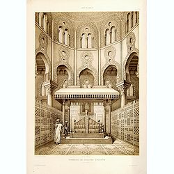
Tombeau de Soultan Qalaoûn.
Lithograph by Bernard Schmidt representing the tomb of sultan Ibn Qalaoun, founder of the mamluk dynasty during the 13th century. The tomb has some rich stained glass and...
Place & Date: Paris, 1877
Sibyl d'Ahmed Hoceyn Margouch.
Lithograph by Fichou. From the author's "L'Art Arabe d'après les monuments du Kaire...". Emile Prisse d'Avennes, Orientalist & Muslim convert, obsessive in...
Place & Date: Paris, 1877
Barbaria. / Egypt / Tunesia.
Three maps on one sheet. Upper part, it shows the coast of Barbaria from Morocco to Egypt: the map on the left corner of Tunis includes a plan of Goletiae, and the right ...
- $300 / ≈ €281
Place & Date: Amsterdam, 1641
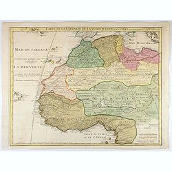
Carte de La Barbarie de La Nigritie et de la Guinée.
A detailed engraved map of north west Africa including the Canary and Cape Verde Islands. Engraved by Inselin. Address and date changed, now with the imprint "A Pari...
Place & Date: Paris, 1781
Monument Sépulcral près de Kymân El-Gyouchy. (XVIIIe. siècle)
Highly decorative lithography by Asselineau, representing a mausoleum. From the author's "L'Art Arabe d'après les monuments du Kaire?". Emile Prisse d'Avennes,...
Place & Date: Paris, 1877

Carte de L'Egypte de la Nubie de L'Abissinie..
Prepared by G.de l'Isle. Uncommon issue by Hendrik de Leth. Very detailed map of northeastern Africa, the Red Sea and the Arabian peninsula shows the political divisions ...
- $500 / ≈ €468
Place & Date: Amsterdam 1740

Barbariae et Biledulgerid, nova descriptio.
North-West Africa. Koeman speculated: "In view of the important trading relationship between Antwerp and Africa, it is not impossible that the original was a manuscr...
Place & Date: Antwerp, 1598
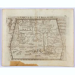
Tabula Africae IIII.
Gastaldi's map of the Northern Africa, based on Ptolemy. Showing all of the Mediterranean, Ethiopian Interior, the Red Sea, Egypt, the source of the Nile, Red Sea, Dead S...
- $400 / ≈ €374
Place & Date: Venice, 1548
.Aphricae Tabula secunda continet.
An important early map of the northern coast of Africa and including parts of the islands of Sicily and Sardine.
Place & Date: Vienne, 1541

De Cust van Barbaria, Gualata, Arguyn, en Gene..heo, van Capo S.Vincente tot Capo Verde.
An eye-catching chart of the north western coast of Africa. Including Canary Islands, Cape Verde Islands and Azores.Pieter Goos (ca. 1616-1675) was one of the most import...
Place & Date: Amsterdam, 1666

De Cust van Barbaryen van out Mamora tot Capo Blanco..
Six charts on one sheet. The two upper charts covering an area from Cape Blanc to Casablanca. In lower part four insets with detailed charts of islands as Madera, Porto S...
Place & Date: Amsterdam, 1666
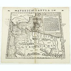
Aphricae Tabula I. (Mauritania - present-day Morocco, Algeria, and Tunisia.)
Double-page woodcut Ptolemaic-style map by Sebastian Münster figuring Mauritania, present-day Morocco, Algeria, and Tunisia, published in the edition of Strabo by Henri ...
Place & Date: Basle, Henri Petri, 1571
![Red Sea - Strait of Jubal.. [2838]](/uploads/cache/23496-250x250.jpg)
Red Sea - Strait of Jubal.. [2838]
Large chart focused on the Strait of Jubal in the Gulf of Suez. With the Juzur Tawilah Islands at the center and an inset plan of the Tur Harbour (At Tur, South Sinai) o...
- $500 / ≈ €468
Place & Date: London (1853) corrected for 1862
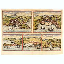
Tingis, Lusitanis, Tangiara. / Tzaffin. / Septa. / Arzilla/ Sala.
Views of the five northern and western African coastal town-view on one sheet: Latin text.From the greatest publication in this genre!. The Civitates was compiled and wri...
- $600 / ≈ €561
Place & Date: Cologne, 1580
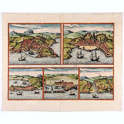
Tingis, Lusitanis, Tangiara. / Tzaffin. / Septa. / Arzilla/ Sala.
Views of the five northern and western African coastal town-view on one sheet: Latin text.From the greatest publication in this genre!. The Civitates was compiled and wri...
- $600 / ≈ €561
Place & Date: Cologne, 1580
Bocche del Fiume Negro et Isole di Capo Verde. . .
This is a splendid map of the northwestern coast of Africa and the Cape Verde Islands.The map provides details of the various Portuguese discoveries in the region in the ...
- $600 / ≈ €561
Place & Date: Venice, 1696
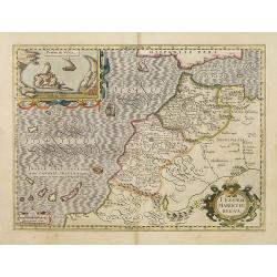
Fezzae et Marocchi regna Africae celeberrima.
North to the right. Showing the Atlas Mountains in the south to the southern coast of Spain, along the coast at Ceuta, Tangiers, and Arzilla.A finely engraved, decorative...
- $650 / ≈ €608
Place & Date: Amsterdam, 1644

Natoliae.. Aegypti recentior.. Carthaginis ( 3 maps on 1 sheet)
Three maps on one sheet. Map to the left east to the top. Detailed map Turkey, including Cyprus and Crete. Also map of the Nile delta and another map of Tunis. From "...
- $750 / ≈ €702
Place & Date: Antwerp, 1587

.Caarte voor een gedeelte der Canarise Eylanden als Canaria, Tenerifa, Forteventura, etc.
Very rare chart of the Canaries. Showing Palma, Ferro, Tenerife, Gran Canaria, Forteventura, Lancerota. In upper right hand corner inset of harbour of Lancerota.
- $1000 / ≈ €936
Place & Date: Amsterdam, 1666

Carte de L\'Egypte de la Nubie de L\'Abissinie. . .
Prepared by G.de l'Isle. Uncommon issue by Hendrik de Leth. Very detailed map of northeastern Africa, the Red Sea and the Arabian peninsula shows the political divisions ...
Place & Date: Amsterdam, 1740

Le cours entier du grand et Fameux Nil. . .
Scarce. A splendid map of ancient Egypt. West is at the top and the Nile bisects Egypt. A inset shows modern Egypt to good detail. With the Red Sea and part of the Arabia...
Place & Date: Augsburg, 1760
![Tabula IIII Aphricae. [with Prester John]](/uploads/cache/42945-250x250.jpg)
Tabula IIII Aphricae. [with Prester John]
Early Ptolemaic woodcut map of the regions of Africa that were known to the ancients. The twin lake sources of the Nile are located near the Mons Lune (Mountains of the M...
- $950 / ≈ €889
Place & Date: Vienna, 1522- 1535

Nouvelle carte du Roiaume D'Alger divisée en toutes ses provinces, avec une partie due cotes D'Espagne . . .
Rare and detailed map of the coast of Algeria. Large inset map of the Bay of Alger (El-Jazir). Shows a coastline of Spain around Alicante. Two compass roses in the Medite...
Place & Date: Amsterdam, 1720

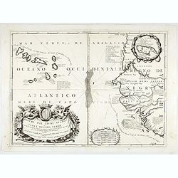
Insulae de Cabo Verde olim Hesperides sive .. Zoute Eylanden.
Original copper engraving, hand colored in outline, when published. Double page chart covering detailed the Cap Verde Islands in the Atlantic Ocean (Isla de San Antonia, ...
Place & Date: Amsterdam, 1655

Manoeuvres executées du 7 au 13 mai sous le Commandement du général Koeltz,par le XIXe Corps d'Armée. . .
Poster by Gaston Ry [aka René Rostagny] (1902-1978) showing the allied manouvers in Tunesia. On May 4, 1943, the nineteenth CA offensive drew most of the German tanks to...
Place & Date: Alger, Bacconnier, 1943

.Tabu nova partis Aphri.
Based on Waldseemüller's map. The maps show Northern Africa as it was known to Europeans at the first part of the 16th century. There is great details across north Afric...
Place & Date: Lyons, M. Servetus, 1535

Nieuwe Pascaert van al de Carnarisse Eylanden. . .
So-called "Blue-back" sea- charts of the Canary Islands.Latitude scale, compass rose and system of rhumb lines, soundings, anchorage's, etc. A wealth of cities ...
Place & Date: Amsterdam, 1700
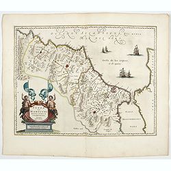
Fessae et Marocchi Regna.
One of the new maps added by Hondius, when he took over publication of the Atlas, a finely engraved and decorative map of north-west Africa, with the Canaries. With an in...
Place & Date: Amsterdam, 1630
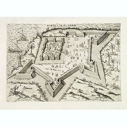
Fortezza di Gerbi.
Rare and early plan the fortress in present-day Jarbah Hawmat-as on the Tunisian island of Djerba, the largest African island in the Mediterranean.The fortress is still o...
- $2200 / ≈ €2059
Place & Date: Rome, 1586 / 1602

Tabula Prima Africa.
The map apart from depicting Morocco also shows southern Spain and the Balearic Islands. In north Africa the map extends eastwards toward modern day Algeria and to the we...
Place & Date: Strasbourg, 1513

L'Art arabe d'après les monuments du Kaire depuis le VIIe siècle jusqu'à la fin du XVIIIe.
Prisse d’Avennes was one of the foremost scholars of Arabic art and architecture of the 19th century; this work represents the summation of his studies. From the aspect...
Place & Date: Paris, Morel, 1877