Browse Listings in Africa > North Africa

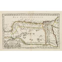
Carte de L'Egypte de la Nubie de L'Abissinie..
Prepared by G.de l'Isle. Uncommon issue by Hendrik de Leth. Very detailed map of northeastern Africa, the Red Sea and the Arabian peninsula shows the political divisions ...
- $500 / ≈ €468
Place & Date: Amsterdam 1740
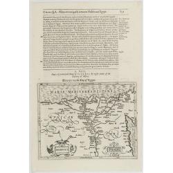
Aegyptus.
The rare Samuel Purchas' edition of the Mercator/Hondius Atlas Minor atlas map. Early map of Egypt published in his famous collection of voyages His Pilgrimes . With desc...
- $150 / ≈ €140
Place & Date: London, 1625
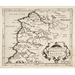
Marocchi Regnum.
From the Mercator/Hondius Atlas Minor. Early map of Morocco.
Place & Date: Amsterdam, 1645

.Caarte voor een gedeelte der Canarise Eylanden als Canaria, Tenerifa, Forteventura, etc.
Very rare chart of the Canaries. Showing Palma, Ferro, Tenerife, Gran Canaria, Forteventura, Lancerota. In upper right hand corner inset of harbour of Lancerota.
- $1000 / ≈ €936
Place & Date: Amsterdam, 1666

Natoliae.. Aegypti recentior.. Carthaginis ( 3 maps on 1 sheet)
Three maps on one sheet. Map to the left east to the top. Detailed map Turkey, including Cyprus and Crete. Also map of the Nile delta and another map of Tunis. From "...
- $750 / ≈ €702
Place & Date: Antwerp, 1587

Le cours entier du grand et Fameux Nil. . .
Scarce. A splendid map of ancient Egypt. West is at the top and the Nile bisects Egypt. A inset shows modern Egypt to good detail. With the Red Sea and part of the Arabia...
Place & Date: Augsburg, 1760

De Cust van Barbaryen van out Mamora tot Capo Blanco..
Six charts on one sheet. The two upper charts covering an area from Cape Blanc to Casablanca. In lower part four insets with detailed charts of islands as Madera, Porto S...
Place & Date: Amsterdam, 1666

De Cust van Barbaria, Gualata, Arguyn, en Gene..heo, van Capo S.Vincente tot Capo Verde.
An eye-catching chart of the north western coast of Africa. Including Canary Islands, Cape Verde Islands and Azores.Pieter Goos (ca. 1616-1675) was one of the most import...
Place & Date: Amsterdam, 1666
![[69] Barbarie.](/uploads/cache/12841-250x250.jpg)
[69] Barbarie.
Charming chart of the harbour of the province of Barbarie in Syria. Showing town and harbour plan, with soundings, anchorages, rocks, shoals, fortifications and lighthous...
- $75 / ≈ €70
Place & Date: Marseille 1764
![[71] Barbarie.](/uploads/cache/12843-250x250.jpg)
[71] Barbarie.
Charming chart of the harbour of the province of Barbarie in Syria. Showing town and harbour plan, with soundings, anchorages, rocks, shoals, fortifications and lighthous...
- $50 / ≈ €47
Place & Date: Marseille 1764
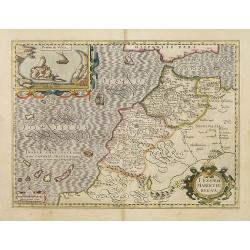
Fessae et Marocchi Regna.
One of the new maps added by Hondius, when he took over publication of the Atlas, a finely engraved and decorative map of north-west Africa, with the Canaries. With an in...
Place & Date: Amsterdam, 1630
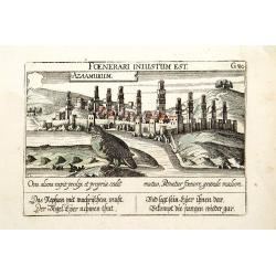
Azaamurum.
A very nice view of the town of Azemmour in Morocco. With a verse in two languages underneath the picture.The poet and topographer from Comothau, Daniel Meisner (1585-162...
- $80 / ≈ €75
Place & Date: Frankfurt, 1623-1678
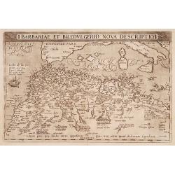
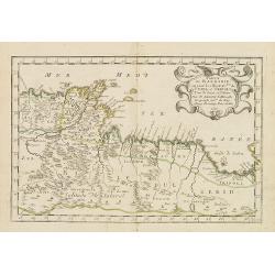
Barbariae et Biledulgerid, nova descriptio.
North-West Africa. Koeman speculated: In view of the important trading relationship between Antwerp and Africa, it is not impossible that the original was a manuscript ma...
- $300 / ≈ €281
Place & Date: Antwerp, 1587
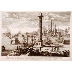
Alexandrie Ville d'Egipte sur la mer Méditeranée..
A very RARE panoramic view of the city of Alexandria, including a legend in the lower part. The plate is numbered in brown pencil in the upper right corner.Engraved by Pi...
- $100 / ≈ €94
Place & Date: Paris, c. 1690
L'Egypte Ancienne et Moderne..
Rare map of Egypt, prepared after J.B.Nolin and published by Monhare for his Atlas Général a l'usage des colleges et maisons d'education.. Louis Joseph Mondhare publish...
- $300 / ≈ €281
Place & Date: Paris, 1783
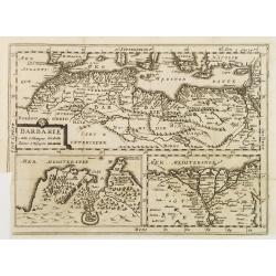
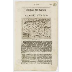
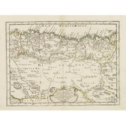
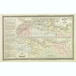
BARBARIE.
An uncommon and delightful map of Northern Africa extends from today's territory of Morocco as far as the Red Sea.With Inset maps of the Nile Delta and the Gulf of Tunis.
- $100 / ≈ €94
Place & Date: Amsterdam, 1700
![Red Sea - Strait of Jubal.. [2838]](/uploads/cache/23496-250x250.jpg)
Red Sea - Strait of Jubal.. [2838]
Large chart focused on the Strait of Jubal in the Gulf of Suez. With the Juzur Tawilah Islands at the center and an inset plan of the Tur Harbour (At Tur, South Sinai) o...
- $500 / ≈ €468
Place & Date: London (1853) corrected for 1862
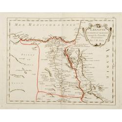
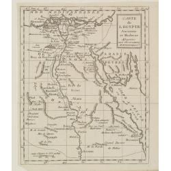
Carte de l'Egypte Ancienne et Moderne..
Attractive map showing part of the course of the river Nile. Boundaries are outlined in hand color.Ornated with a decorative title cartouche representing a crocodile flan...
- $150 / ≈ €140
Place & Date: Paris, ca 1783
Carte de l'Egypte Ancienne et Moderne..
Map of Egypt illustrating part of the course of the river Nile. From Atlas de la Géographie de toutes les parties du monde .. Ouvrage destiné pour l'education, et néce...
Place & Date: Paris, Prudhomme, Levrault, Debray, 1806
Tunetanum Regnum.
Small map representing Tunisia and Algeria, surrounded by text in Dutch.Nicolaes de Clerck (de Klerc) was active as engraver and publisher in Delft from 1599-1621.Include...
Place & Date: Amsterdam, Cloppenburch, 1621
Aegyptus.
A small map focused on the Nile Delta, where the Nile divides into several branches.Included in the rare book : Wereld Spiegel, waer in vertoontword de Beschryvinge der R...
- $100 / ≈ €94
Place & Date: Amsterdam, Cloppenburch, 1621
Royaume et desert de Barca, et Aegypte divisee. . .
Map of Egypt prepared by N.Sanson and published by Pierre Mariette.Published in an early edition of the small Sanson atlas L'Europe Dediée a Monseigneur . . . Le Tellier...
- $100 / ≈ €94
Place & Date: Paris, P. Mariette, 1667
Partie de la Barbarie ou sont les royaumes de Tunis et Tripoli. . .
Coastal map of Tunisia and Libya prepared by N.Sanson and published by Pierre Mariette.Published in an early edition of the small Sanson atlas L'Europe Dediée a Monseign...
- $750 / ≈ €702
Place & Date: Paris, P. Mariette, 1667
Partie de la Barbarie ou est le royaume d'Alger. . .
Coastal map of North Africa prepared by N.Sanson and published by Pierre Mariette.Published in an early edition of the small Sanson atlas L'Europe Dediée a Monseigneur ....
- $80 / ≈ €75
Place & Date: Paris, P. Mariette, 1667
Royaume de Fez. . .
Map of Morocco prepared by N.Sanson and published by Pierre Mariette.Published in an early edition of the small Sanson atlas L'Europe Dediée a Monseigneur . . . Le Telli...
- $120 / ≈ €112
Place & Date: Paris, P. Mariette, 1667
![Carthage, etc. [Foliu XL ]](/uploads/cache/26122-250x250.jpg)
Carthage, etc. [Foliu XL ]
VERSO: Portraits of scholars, and an imaginary view on Carthage in Tunisia (12x17cm.) Page from the famous Liber chronicarum of Hartmann-Schedel 1493, the first and Latin...
Place & Date: Nuremberg 12 July 1493

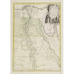
Carte de L\'Egypte de la Nubie de L\'Abissinie. . .
Prepared by G.de l'Isle. Uncommon issue by Hendrik de Leth. Very detailed map of northeastern Africa, the Red Sea and the Arabian peninsula shows the political divisions ...
Place & Date: Amsterdam, 1740
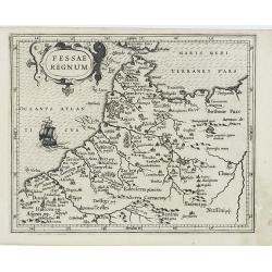
Fessae Regnum.
Charming small map of the northwestern tip of Africa with Fez showing as the principal city. Decorative title cartouche.From a Latin-text edition of Jodocus Hondius' Atla...
- $120 / ≈ €112
Place & Date: Amsterdam, 1608
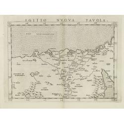
Egitto nuova tavola.
Fine early map of Egypt and the Nile delta. Extends east to the Upper Red Sea and West to "Deserto De Marmarica". Nice detail in the lower Nile regions. Page ta...
- $200 / ≈ €187
Place & Date: Venice, 1561
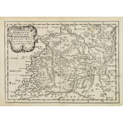
'T Koninkryk van Marocco, verdeelt in Zeven Landschappen, enz. . .
A Dutch edition of this finely engraved map of Morocco filled with mountain ranges, oases and cities. The map is adorned with a decorative cartouche.
- $90 / ≈ €84
Place & Date: Amsterdam, ca. 1705
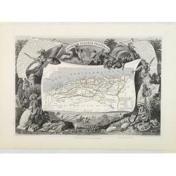
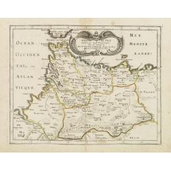
Algérie, Colonie Française. N°87.
Map of Algeria.Lovely map from one of the last decorative atlases of the nineteenth century.The rather simple map is framed by medallion portraits and coats of arms, and ...
Place & Date: Paris, A. Combette, 1852

Nouvelle carte du Roiaume D'Alger divisée en toutes ses provinces, avec une partie due cotes D'Espagne . . .
Rare and detailed map of the coast of Algeria. Large inset map of the Bay of Alger (El-Jazir). Shows a coastline of Spain around Alicante. Two compass roses in the Medite...
Place & Date: Amsterdam, 1720

Insulae de Cabo Verde olim Hesperides sive .. Zoute Eylanden.
Original copper engraving, hand colored in outline, when published. Double page chart covering detailed the Cap Verde Islands in the Atlantic Ocean (Isla de San Antonia, ...
Place & Date: Amsterdam, 1655

Nieuwe Pascaert van al de Carnarisse Eylanden. . .
So-called "Blue-back" sea- charts of the Canary Islands.Latitude scale, compass rose and system of rhumb lines, soundings, anchorage's, etc. A wealth of cities ...
Place & Date: Amsterdam, 1700
Marok Alger et Tunis. / Etat de Tripoli.
Two maps on one sheet. Finely engraved map of North Africa and Libya, prepared by A.H.Dufour and engraved by Giraldon-Bovinet. Published by Jules Renouard in his uncommon...
- $40 / ≈ €37
Place & Date: Paris, Jules Renouard, ca.1840

.Tabu nova partis Aphri.
Based on Waldseemüller's map. The maps show Northern Africa as it was known to Europeans at the first part of the 16th century. There is great details across north Afric...
Place & Date: Lyons, M. Servetus, 1535
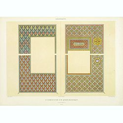
Arabesques. - Ornementation d'un Qoran Mauresque (XVIIIe siècle)
Lithographed by Daumont. From the author's "L'Art Arabe d'après les monuments du Kaire…". Emile Prisse d'Avennes, Orientalist and Muslim convert, obsessive i...
Place & Date: Paris, 1877
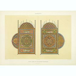
Arabesques. - Pages jumelles d'un qorân mauresque. (XVIIIe siècle)
Lithographed by Daumont. From the author's "L'Art Arabe d'après les monuments du Kaire…". Emile Prisse d'Avennes, Orientalist and Muslim convert, obsessive i...
Place & Date: Paris, 1877
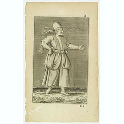
Esclave More. (38)
Sought-after copper engraved plate of a Moor slave from North Africa. Plate from Laonikos Chalcocondyle’s "L'histoire de la décadence de l'empire grec et establis...
- $75 / ≈ €70
Place & Date: Paris, Mathieu Guillemot, 1650
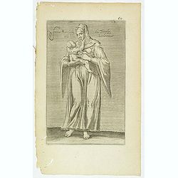
Femme moresque de Tripoly en Barbarie. (60)
Sought-after copper engraved plate of a woman with child from Tripoli. Plate from Laonikos Chalcocondyle’s "L'histoire de la décadence de l'empire grec et establi...
- $45 / ≈ €42
Place & Date: Paris, Mathieu Guillemot, 1650