Browse Listings in Africa > North Africa
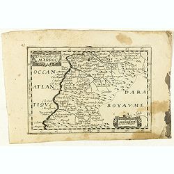
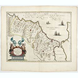
Le Royaume de Marroc.
Rare map of Morocco published by Jollain in 1667. Published in "Trésor Des Cartes Geographiques Des Principaux Estats de Lunivers".This atlas is based upon Boi...
- $100 / ≈ €94
Place & Date: Paris, 1667
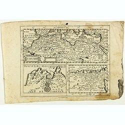
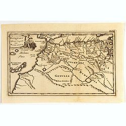
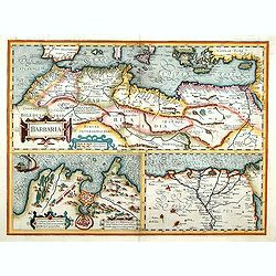
Barbarie.
Rare map of the Barbary Coast of Africa published by Jollain in 1667. Published in "Trésor Des Cartes Geographiques Des Principaux Estats de Lunivers".This atl...
- $100 / ≈ €94
Place & Date: Paris, 1667
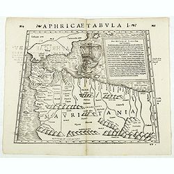
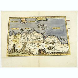
Aphricae Tabula I. (Mauritania - present-day Morocco, Algeria, and Tunisia.)
Double-page woodcut Ptolemaic-style map by Sebastian Münster figuring Mauritania, present-day Morocco, Algeria, and Tunisia, published in the edition of Strabo by Henri ...
Place & Date: Basle, Henri Petri, 1571
![Tabula IIII Aphricae. [with Prester John]](/uploads/cache/42945-250x250.jpg)
Tabula IIII Aphricae. [with Prester John]
Early Ptolemaic woodcut map of the regions of Africa that were known to the ancients. The twin lake sources of the Nile are located near the Mons Lune (Mountains of the M...
- $950 / ≈ €889
Place & Date: Vienna, 1522- 1535
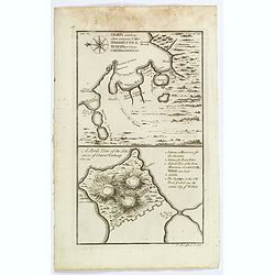
Charta exhibens Situm antiquum Carthaginis, Uticae. . . / A Bird's View of the Situation of Antient Carthage.
A pair of engravings of ancient Carthage in North Africa, from Charles Rollins' "The Ancient History of the Egyptians, Carthaginians, Assyrians, Babylonians, medes &...
- $50 / ≈ €47
Place & Date: London, ca 1768
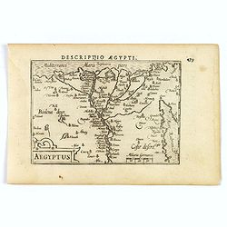
Aegyptus.
A fine miniature map of Egypt, published by Petrus Bertius in Amsterdam early in the seventeenth century. The lovely map and has a strap-work title, in the lower left cor...
- $100 / ≈ €94
Place & Date: Amsterdam, 1606
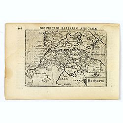
Barbaria.
A nice miniature map of the north African region known as 'Barbary', published by Petrus Bertius in Amsterdam early in the seventeenth century. This lovely map also depic...
- $100 / ≈ €94
Place & Date: Amsterdam, 1606
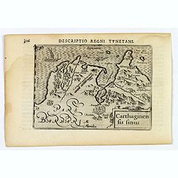
Carthaginensis Sinus.
A beautifully miniature map by Petrus Bertius of the ancient city of Carthage and the more modern town of Tunis, first published in 1598. There are numerous features tha...
- $100 / ≈ €94
Place & Date: Amsterdam, 1606
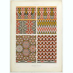
Arabesques. - Mosaïques Murales.
Lithographed by Daumont. From the author's "L'Art Arabe d'après les monuments du Kaire…". Emile Prisse d'Avennes, Orientalist and Muslim convert, obsessive i...
Place & Date: Paris, 1877

Manoeuvres executées du 7 au 13 mai sous le Commandement du général Koeltz,par le XIXe Corps d'Armée. . .
Poster by Gaston Ry [aka René Rostagny] (1902-1978) showing the allied manouvers in Tunesia. On May 4, 1943, the nineteenth CA offensive drew most of the German tanks to...
Place & Date: Alger, Bacconnier, 1943
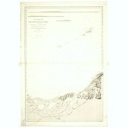
Carte particuliere de la cote septentrionale d'Afrique. (13eme feuille)
A fine French Service Hydrograhique de la Marine chart no. 3424, showing Cape Rose and Cap Nègre, in Algeria, drawn in 1873 by E. Mouchez, updated to 1913. Chart engrave...
- $80 / ≈ €75
Place & Date: Paris, 1873 / 1913
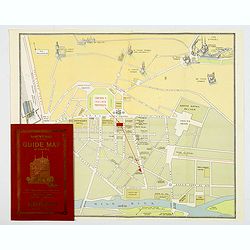
Souvenir Guide Map of Cairo.
A lovely small colored plan of central Cairo, published by Groppi in Cairo. Plan is housed within the original red and gold printed paper covers, with advertisements for ...
- $200 / ≈ €187
Place & Date: Cairo, 1920-1950
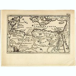
Aegyptus Et Cyrene.
A fine coastal region of Libya, also known as Pentapolis in antiquity. From "Introductio in Universam Geographicam" and edited by Johann Friedrich Heckel Philli...
- $50 / ≈ €47
Place & Date: London, 1697
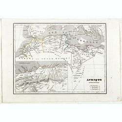
Afrique Septentrionale.
Detailed map of the Northern part of Africa, prepared by Charles V. Monin (fl.1830-1880) a French cartographer of Caen and Paris. Published in Atlas Universel de Géograp...
- $45 / ≈ €42
Place & Date: Paris, 1845
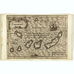
Canariae I.
Small map of the Canary Island. Nicolaes de Clerck (de Klerc) was active as engraver and publisher in Delft from 1599-1621.Included in the rare book : Wereld Spiegel, wae...
Place & Date: Amsterdam, Cloppenburch, 1621
Fezzae et Marocchi regna Africae celeberrima.
North to the right. Showing the Atlas Mountains in the south to the southern coast of Spain, along the coast at Ceuta, Tangiers, and Arzilla.A finely engraved, decorative...
- $650 / ≈ €608
Place & Date: Amsterdam, 1644
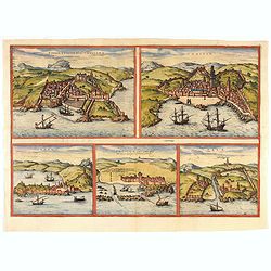
Tingis, Lusitanis, Tangiara. / Tzaffin. / Septa. / Arzilla/ Sala.
Views of the five northern and western African coastal town-view on one sheet: Latin text.From the greatest publication in this genre!. The Civitates was compiled and wri...
- $600 / ≈ €561
Place & Date: Cologne, 1580
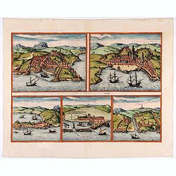
Tingis, Lusitanis, Tangiara. / Tzaffin. / Septa. / Arzilla/ Sala.
Views of the five northern and western African coastal town-view on one sheet: Latin text.From the greatest publication in this genre!. The Civitates was compiled and wri...
- $600 / ≈ €561
Place & Date: Cologne, 1580
Mauritana et Africa Proria nunc Barbaria.
A pleasantly engraved map of the north-western part of Africa with the Canary Islands by Phillip Clüver after Strabo. With one cartouche.Phillip Cluver was a German geog...
- $50 / ≈ €47
Place & Date: Leiden, 1697
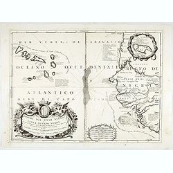
Bocche del Fiume Negro et Isole di Capo Verde. . .
This is a splendid map of the northwestern coast of Africa and the Cape Verde Islands.The map provides details of the various Portuguese discoveries in the region in the ...
- $600 / ≈ €561
Place & Date: Venice, 1696
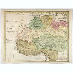
Carte de La Barbarie de La Nigritie et de la Guinée.
A detailed engraved map of north west Africa including the Canary and Cape Verde Islands. Engraved by Inselin. Address and date changed, now with the imprint "A Pari...
Place & Date: Paris, 1781
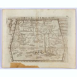
Tabula Africae IIII.
Gastaldi's map of the Northern Africa, based on Ptolemy. Showing all of the Mediterranean, Ethiopian Interior, the Red Sea, Egypt, the source of the Nile, Red Sea, Dead S...
- $400 / ≈ €374
Place & Date: Venice, 1548
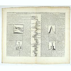
Description du Nil, de ses sources, de son cours depuis les cataractes jusques le Caire . . .
Detailed map of the course of the Nile, from the cataracts of the Nile at the south (top of the image) to Caïro and Giza. At the right, one of the Pyramids is shown (140...
Place & Date: Amsterdam, 1728
![[Lot of 25 leaves of Africa and Egypt]](/uploads/cache/48275-250x250.jpg)
[Lot of 25 leaves of Africa and Egypt]
Twenty-five text leaves with wood block illustrations relating to Africa and Egypt illustrated with maps, animals, plants.... From the 1552 Latin text edition of Münster...
- $100 / ≈ €94
Place & Date: Basel, 1552

Paskaart van de kust van Maroca beginnende van Larache tot aan C. Cantin. . .
A nautical sea chart of the coast of Morocco. Insert at top right: 'Nieuwe Afbeelding van de Rivier Rio Rebata in 't Groot".Bottom right: chart number '32'. Compass ...
Place & Date: Amsterdam, ca.1682
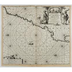
Paskaart van de Kuste van, Gualate en Arguyn. Beginnende van C. Bajador tot C. Blanco. . .
A nautical showing the northwestern coast of Africa, along Western Sahara from Cape Bojador to Cape Blanc. Ornate title cartouche in top right corner shows two main figur...
Place & Date: Amsterdam, ca.1682
Barbaria. / Egypt / Tunesia.
Three maps on one sheet. Upper part, it shows the coast of Barbaria from Morocco to Egypt: the map on the left corner of Tunis includes a plan of Goletiae, and the right ...
- $300 / ≈ €281
Place & Date: Amsterdam, 1641
.Aphricae Tabula secunda continet.
An important early map of the northern coast of Africa and including parts of the islands of Sicily and Sardine.
Place & Date: Vienne, 1541
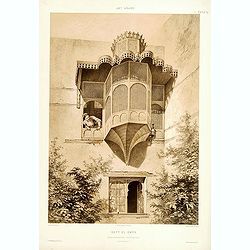
Beyt El-Emyr.
Lithograph by Mouilleron representing a young woman looking over a beautiful moucharabieh. From the author's "L'Art Arabe d'après les monuments du Kaire?". Emi...
Place & Date: Paris, 1877
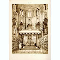
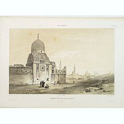
Tombeau de Soultan Qalaoûn.
Lithograph by Bernard Schmidt representing the tomb of sultan Ibn Qalaoun, founder of the mamluk dynasty during the 13th century. The tomb has some rich stained glass and...
Place & Date: Paris, 1877
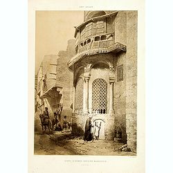
Sibyl d'Ahmed Hoceyn Margouch.
Lithograph by Fichou. From the author's "L'Art Arabe d'après les monuments du Kaire...". Emile Prisse d'Avennes, Orientalist & Muslim convert, obsessive in...
Place & Date: Paris, 1877
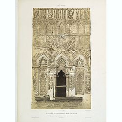
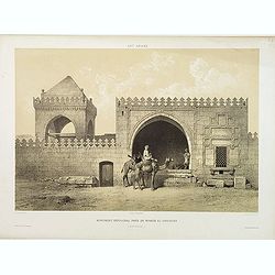
Mosquée de Mohammed Ben Qalaoûn. Details du Minaret Partie Inférieure. (XIVe. siècle)
Highly decorative lithography by Asselineau, showing architectural details of the minaret of Qalaoûn's mosque in Cairo. From the author's "L'Art Arabe d'après les ...
- $150 / ≈ €140
Place & Date: Paris, 1877
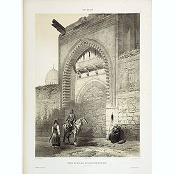
Porte du Palais du Soultan Beybars. (XIIIe. siècle)
Highly decorative lithography by Ch. Fichot, showing the walled-up entrance of Sultan Beybars' palace. From the author's "L'Art Arabe d'après les monuments du Kaire...
Place & Date: Paris, 1877
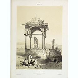
Tombeau d'un Emir. (XIIIe. siècle)
Highly decorative lithography by Ch. Fichot, representing the mausoleum of an emir. From the author's "L'Art Arabe d'après les monuments du Kaire". Emile Priss...
- $150 / ≈ €140
Place & Date: Paris, 1877
Tombeau du Soultan Tarabey. (XVIe. siècle)
Highly decorative lithography by Ch. Fichot, representing Sultan Tarabey's mausoleum. From the author's "L'Art Arabe d'après les monuments du Kaire?". Emile Pr...
Place & Date: Paris, 1877
Monument Sépulcral près de Kymân El-Gyouchy. (XVIIIe. siècle)
Highly decorative lithography by Asselineau, representing a mausoleum. From the author's "L'Art Arabe d'après les monuments du Kaire?". Emile Prisse d'Avennes,...
Place & Date: Paris, 1877

L'Art arabe d'après les monuments du Kaire depuis le VIIe siècle jusqu'à la fin du XVIIIe.
Prisse d’Avennes was one of the foremost scholars of Arabic art and architecture of the 19th century; this work represents the summation of his studies. From the aspect...
Place & Date: Paris, Morel, 1877