Browse Listings in East Meets West > India
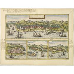
Calechut Celeberri mum Indiae Emporium/ Ormus/ Canonor, St.Georgii.
Four panoramic town-views on one sheet: The upper approximately two-thirds of this double-page sheet contains a fine panoramic view of Calicut which is on the west coast ...
Date: Cologne, 1580
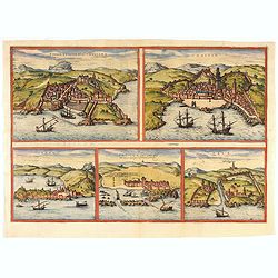
Tingis, Lusitanis, Tangiara. / Tzaffin. / Septa. / Arzilla/ Sala.
Views of the five northern and western African coastal town-view on one sheet: Latin text.From the greatest publication in this genre!. The Civitates was compiled and wri...
- $600 / ≈ €509
Date: Cologne, 1580
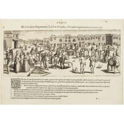
De foro Goae frequentato..
An attractive panorama view of the market square at Goa, with Indians and Portuguese traders, buying and selling various merchandise, with a row of colonial buildings in ...
Date: Frankfurt, 1607
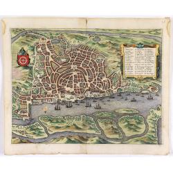
Goa.
A finely engraved, detailed town-plan of Goa, the main Portuguese trading post in India. It also appeared in Gottfried’s Archontologia (1649). There is a cartouche iden...
Date: Frankfurt, 1680
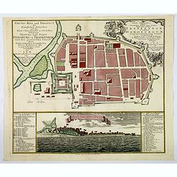
Grund=Riss und Prospect der Koniglichen Danischen auf der Kuste Choromandel in Ost-Indien belegenen Vestung und Stadt Dansburg u Trankenbar . . .
The Danish East India Company was founded in 1616. A first expedition was sent out in November 1618, which led to the purchase of a parcel of land on the Coromandel coast...
Date: Augsburg ca 1740

Cochin (today: Ernakulam)
Small but charming 18th water color on paper depicting Cochin (today : Ernakulam) was from 1500, when the first Portuguese fleet called on its port, a firm ally of the Po...
Date: India? c.1750
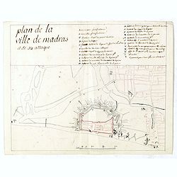
Plan de la ville de Madras et de ses attaques.
Manuscript map, in black, brown and red ink, showing the fortifications of the city of Madras, now Chennai, on the east coast of India, north of Pondicherry.Showing the c...
- $2000 / ≈ €1696
Date: Paris, ca 1760
![Plan de Gingy, ville et forteresse d'Asie . . . [An Early Manuscript Map of Pondicherry Prior To Its Reconstruction After The Seven Years War.]](/uploads/cache/43006-250x250.jpg)
Plan de Gingy, ville et forteresse d'Asie . . . [An Early Manuscript Map of Pondicherry Prior To Its Reconstruction After The Seven Years War.]
An early manuscript map of Gingy shortly after The Seven Years War, when the French took possession of large part of India.With an extensive key to the left.Gingee Fort o...
- $1500 / ≈ €1272
Date: Paris, 1765
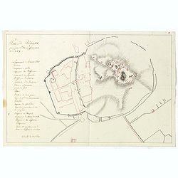
Plan de Thiagar, prise par l'arméé française en 1759.
An early manuscript map of Thiagar. With an extensive unfinished key to the left. The map was drawn shortly after the end of the Seven Years War, when the French took pos...
- $750 / ≈ €636
Date: Paris, 1769
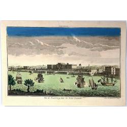
Vue de la Pondichery dans les Indes Orientales
Pondicherry is the capital city of Indian union territory of Puducherry. Pondicherry is situated in Puducherry district of the union territory in India. The vue was produ...
Date: Paris, 1780
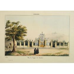
Pondichery - Vue de l'Eglise des Jésuites.
Constructed in 1791, it is regarded as the main mother church of Roman Catholic Archdiocese of Pondicherry and Cuddalore. To one’s surprise, this famous church in Pondi...
- $300 / ≈ €254
Date: Paris, 1843

